Pretty active system coming up with a series of fronts and a deep low for the week ahead. Widespread falls, though mostly light to moderate away from the usual wet spots.
With very warm SSTs and cold air aloft would not surprise to see some strong coldies. Snow likely on the alps, which could be quite heavy but with warm sun and ground won’t stick for long.

Welcome New Members! We want to hear from you. Register, stop lurking and start posting!
Becoming cooler with showers and storms, snow on the alps: Feb 1-5
-
hillybilly

- Site Admin/Moderator
- Reactions:
- Posts: 4980
- Joined: Thu Nov 26, 2009 7:26 am
- Location: Howden Tasmania, 25m above sea level
- Contact:
- StratoBendigo
- Supercell
- Reactions:
- Posts: 2809
- Joined: Fri Jan 02, 2015 2:18 pm
- Location: Kangaroo Flat
Re: Becoming cooler with showers and storms, snow on the alps: Feb 1-5
Looks mostly dry here. But I don't mind the cooler weather this time of year. I would much rather this than high-30s+.
The coastal fringe is likely to get a bit with the warm ocean and bay.
The coastal fringe is likely to get a bit with the warm ocean and bay.
-
hillybilly
- Site Admin/Moderator
- Reactions:
- Posts: 4980
- Joined: Thu Nov 26, 2009 7:26 am
- Location: Howden Tasmania, 25m above sea level
- Contact:
Re: Becoming cooler with showers and storms, snow on the alps: Feb 1-5
Guess the first day of this event which slowly ramps with each passing trough. Today, the odd shower and storm over eastern Victoria, bit of drizzle in western Tasmania and possible shower in the east. Tomorrows trough is a long strong with a solid band of showers.
- StratoBendigo
- Supercell
- Reactions:
- Posts: 2809
- Joined: Fri Jan 02, 2015 2:18 pm
- Location: Kangaroo Flat
Re: Becoming cooler with showers and storms, snow on the alps: Feb 1-5
Forecast is still holding firm for cold outbreak later this week.
Worth noting that next week has significant divergence in the model outputs. All over the shop - everything from 0 to 50mm forecast for here.
Worth noting that next week has significant divergence in the model outputs. All over the shop - everything from 0 to 50mm forecast for here.
-
hillybilly
- Site Admin/Moderator
- Reactions:
- Posts: 4980
- Joined: Thu Nov 26, 2009 7:26 am
- Location: Howden Tasmania, 25m above sea level
- Contact:
Re: Becoming cooler with showers and storms, snow on the alps: Feb 1-5
1mm in the gauge here from yesterday’s front. Quite a few showers but all pretty light. Heavier falls out west.
Strong front for today. Heavy falls in northern and western Tasmania and for the southern into mountain areas of Victoria. Wouldn’t be surprised fo see the odd fall over 50mm. This would be a good front for August, with uppers cold enough for snow on the mainland peaks for a good 48 hours. The air over Tasmania is not cold for as long with some warm air advection form the east as a second low bombs on Saturday. Wouldn’t be surprised to see locally around a foot of snow, but won’t stick for long with warm sun and ground temps.
Btw watch for a substantial storm surge. Fortunately tides aren’t very high this week but the pressure drops down toward 990hPa over coastal Vic and sub 1980s in tasmania.
- StratoBendigo
- Supercell
- Reactions:
- Posts: 2809
- Joined: Fri Jan 02, 2015 2:18 pm
- Location: Kangaroo Flat
Re: Becoming cooler with showers and storms, snow on the alps: Feb 1-5
Decent polar jet for February. We might get a few mm this evening.
The monster low and cold outbreak of Feb 2005 still
likely to be the champion of Feb cold weather events for me though.
The monster low and cold outbreak of Feb 2005 still
likely to be the champion of Feb cold weather events for me though.
- stevco123
- Supercell
- Reactions:
- Posts: 2936
- Joined: Sat Aug 07, 2010 7:42 pm
- Location: Cranbourne 78m asl
Re: Becoming cooler with showers and storms, snow on the alps: Feb 1-5
Yep same. Will never forget it. A max of just under 12 that day for south east suburbs.StratoBendigo wrote: ↑Thu Feb 02, 2023 8:32 am Decent polar jet for February. We might get a few mm this evening.
The monster low and cold outbreak of Feb 2005 still
likely to be the champion of Feb cold weather events for me though.
Last edited by stevco123 on Fri Feb 03, 2023 10:16 pm, edited 2 times in total.
https://www.weatherlink.com/bulletin/53 ... 76dd68e8bc: for current weather updated every 2 minutes
-
Blackee

- Site Admin/Moderator
- Reactions:
- Posts: 3857
- Joined: Tue Nov 24, 2009 8:57 pm
- Location: Elwood and Mansfield 370m
Re: Becoming cooler with showers and storms, snow on the alps: Feb 1-5
And 120mm in a day in Melb. Was like a cyclone.StratoBendigo wrote: ↑Thu Feb 02, 2023 8:32 am Decent polar jet for February. We might get a few mm this evening.
The monster low and cold outbreak of Feb 2005 still
likely to be the champion of Feb cold weather events for me though.
Mansfield 370m and Elwood
-
Australis(Shell3155)

- Supercell
- Reactions:
- Posts: 3146
- Joined: Mon Nov 30, 2009 8:05 pm
- Location: FTG
- Contact:
Re: Becoming cooler with showers and storms, snow on the alps: Feb 1-5
ooo... that's hurting the memory..
Just checked the National Radar..
Just checked the National Radar..
-
Blackee
- Site Admin/Moderator
- Reactions:
- Posts: 3857
- Joined: Tue Nov 24, 2009 8:57 pm
- Location: Elwood and Mansfield 370m
Re: Becoming cooler with showers and storms, snow on the alps: Feb 1-5
Front has arrived with a bang bayside. Moderate - heavy rain with the wind change.
How's the satpic!
How's the satpic!
Mansfield 370m and Elwood
- dazrain
- Cumulonimbus
- Reactions:
- Posts: 111
- Joined: Thu Feb 03, 2011 7:39 pm
- Location: Brighton East, Victoria
Re: Becoming cooler with showers and storms, snow on the alps: Feb 1-5
Are we looking at the coldest first week of Feb ever in Melbourne?
Average temp will be about 22 degrees!
Average temp will be about 22 degrees!
- StratoBendigo
- Supercell
- Reactions:
- Posts: 2809
- Joined: Fri Jan 02, 2015 2:18 pm
- Location: Kangaroo Flat
- snowfall
- Supercell
- Reactions:
- Posts: 1284
- Joined: Mon Mar 20, 2017 7:39 pm
- Location: Gisborne South (349m asl)
Re: Becoming cooler with showers and storms, snow on the alps: Feb 1-5
Good solid rain band and better than expected. 18.4mm here.
It's a blue sky now, though some showers are inbound. It's definitely on the chilly side for summer. The temp dropped to 8.2c with the rain band and is currently 10c.
A nice break from an otherwise dry summer.
It's a blue sky now, though some showers are inbound. It's definitely on the chilly side for summer. The temp dropped to 8.2c with the rain band and is currently 10c.
A nice break from an otherwise dry summer.
- StratoBendigo
- Supercell
- Reactions:
- Posts: 2809
- Joined: Fri Jan 02, 2015 2:18 pm
- Location: Kangaroo Flat
Re: Becoming cooler with showers and storms, snow on the alps: Feb 1-5
4mm here. Now clear skies and a chilly 11c outside. Feels like late-Autumn!
- stevco123
- Supercell
- Reactions:
- Posts: 2936
- Joined: Sat Aug 07, 2010 7:42 pm
- Location: Cranbourne 78m asl
Re: Becoming cooler with showers and storms, snow on the alps: Feb 1-5
THUNDER!!!!
Unbelievable to get such a coldie in summer.
EDIT>> Second coldie just went through with heavy rain and small hail.
Unbelievable to get such a coldie in summer.
EDIT>> Second coldie just went through with heavy rain and small hail.
https://www.weatherlink.com/bulletin/53 ... 76dd68e8bc: for current weather updated every 2 minutes
-
hillybilly
- Site Admin/Moderator
- Reactions:
- Posts: 4980
- Joined: Thu Nov 26, 2009 7:26 am
- Location: Howden Tasmania, 25m above sea level
- Contact:
Re: Becoming cooler with showers and storms, snow on the alps: Feb 1-5
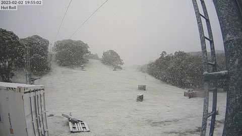
Photo from last night of Baw Baw snow. Decent cover across the Snowys also, but a bit of a miss for the more northern VIC alps and Tasmania which often happens with these very cold systems. Nice and chilly down here near sea level in southern Tas with a minimum of 5.9C. Looking at obs probably a light frost on parts of the Huon and Derwent valleys.
Gonna be a messy day today with two lows dumbelling around each other then consolidating near southwest cape. Showers and storms, but main focus will be through south Gippsland/Otways and western Tas. More snow in the alps. Coastal surge will push water to “minor/nuisance” flood levels in the usual suspects (Lakes Entrance, Tarwin, possibly parts of TAS). Have always found the best coldies happen in the February to early April window, but systems this time of year seem to only come every 5-10 years. Reckon it would be worth a look on the Bass Coast as this is classic water spout weather for that region. These often come ashore as weak landspouts.
Gonna be a messy day today with two lows dumbelling around each other then consolidating near southwest cape. Showers and storms, but main focus will be through south Gippsland/Otways and western Tas. More snow in the alps. Coastal surge will push water to “minor/nuisance” flood levels in the usual suspects (Lakes Entrance, Tarwin, possibly parts of TAS). Have always found the best coldies happen in the February to early April window, but systems this time of year seem to only come every 5-10 years. Reckon it would be worth a look on the Bass Coast as this is classic water spout weather for that region. These often come ashore as weak landspouts.
-
Didjman

- Supercell
- Reactions:
- Posts: 2099
- Joined: Fri Sep 03, 2010 2:52 pm
- Location: Wallan, Vic 328m ASL
- Contact:
Re: Becoming cooler with showers and storms, snow on the alps: Feb 1-5
Today I am planning a Coldie and large surf chase to Pt Lonsdale. Should get some awesome pics and vid of the 2-3m forecast surf breaking against the outgoing tide from the bay. Maybe a waterspout too?
- Macedonian
- Supercell
- Reactions:
- Posts: 2330
- Joined: Mon Dec 21, 2009 10:44 pm
- Location: Mount Macedon Vic at 870m above sea level
Re: Becoming cooler with showers and storms, snow on the alps: Feb 1-5
Very wintry at Mt Macedon this morning.
Just 4.8° and dropping.
My max yesterday was only 11.3°.
My yr app says 12° for me today but I think they are dreaming.
I remember Feb 2005 very well. A huge amount of rain back in the drought years where we were lucky to ever get anything over 10mm in one go in Melbourne.
It was like getting day release on a life sentence.
Lots of trees came down in city centre parks because they had been weakened by the drought. Devestation.
Home- "Shepherd's Bush" at Mt Macedon. 870m
Work- "Bolobek" at Macedon. 430m
Work- "Bolobek" at Macedon. 430m

Re: Becoming cooler with showers and storms, snow on the alps: Feb 1-5
17mm here from yesterdays rain band and a couple of showers overnight.
Interested to see how it sets up today. If we get in the right slot we might double our rain total by this time tomorrow.
Interested to see how it sets up today. If we get in the right slot we might double our rain total by this time tomorrow.
- Macedonian
- Supercell
- Reactions:
- Posts: 2330
- Joined: Mon Dec 21, 2009 10:44 pm
- Location: Mount Macedon Vic at 870m above sea level
Re: Becoming cooler with showers and storms, snow on the alps: Feb 1-5
6.5° at 12 40pm in Feb!
Home- "Shepherd's Bush" at Mt Macedon. 870m
Work- "Bolobek" at Macedon. 430m
Work- "Bolobek" at Macedon. 430m