Reading and confused
Pack up a caravan prior tooo .?

Welcome New Members! We want to hear from you. Register, stop lurking and start posting!
Return of heat followed by possible rain and storms: January 20-30
-
Australis(Shell3155)

- Supercell
- Reactions:
- Posts: 3146
- Joined: Mon Nov 30, 2009 8:05 pm
- Location: FTG
- Contact:
- Tassiedave
- Supercell
- Reactions:
- Posts: 1099
- Joined: Thu Nov 11, 2010 11:09 am
- Location: Grindelwald Tasmania
Re: Return of heat followed by possible rain and storms: January 20-30
Latest BOM forecast for Melbourne says "An oppressive night"
- Skywalker
- Supercell
- Reactions:
- Posts: 1872
- Joined: Sun Nov 29, 2009 10:03 am
- Location: Burnside Heights/Cowes (Home) & Sunshine West (Work)
Re: Return of heat followed by possible rain and storms: January 20-30
A warm 32°C here at Cowes down on the island with hardly any wind. Been ideal conditions for the beach. Love the fact that our beach is one of those rare north facing ones in Victoria. 
Shocking night coming up, 27 for Melbourne, about 5 degrees cooler here. Might have to sleep on the foreshore tonight.
Shocking night coming up, 27 for Melbourne, about 5 degrees cooler here. Might have to sleep on the foreshore tonight.
Caroline Springs, Melbourne's meteorological boredom zone.
-
Didjman

- Supercell
- Reactions:
- Posts: 2099
- Joined: Fri Sep 03, 2010 2:52 pm
- Location: Wallan, Vic 328m ASL
- Contact:
Re: Return of heat followed by possible rain and storms: January 20-30
Reached a top of 37.1 at 328m! Insane. What will tomorrow deliver??
Re: Return of heat followed by possible rain and storms: January 20-30
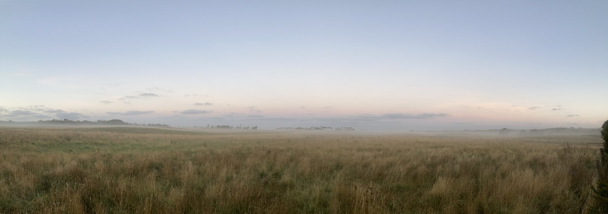
Beautiful photo HB.hillybilly wrote: ↑Sat Jan 23, 2021 7:49 am
Calm and misty down here in Walkerville. Nice morning. Here’s a photo looking west towards Venus Bay from the back deck
Hot here like everywhere. Cloud is tempering things a bit though. This part of the NE really wants some rain having missed out from recent successive systems.
Models suggesting ranges of 20-70mm this week for Mansfield district. Keeping optimistic

- Tassiedave
- Supercell
- Reactions:
- Posts: 1099
- Joined: Thu Nov 11, 2010 11:09 am
- Location: Grindelwald Tasmania
Re: Return of heat followed by possible rain and storms: January 20-30
Wow Melbourne! It's not often you see the maximum temperature reached at 6.57 pm!! 37.8 degrees
- QldTwister
- Cumulonimbus
- Reactions:
- Posts: 434
- Joined: Tue May 22, 2012 7:56 pm
- Location: Ashwood Vic
Re: Return of heat followed by possible rain and storms: January 20-30
Bloodly RIPPER day late Max love that 38c and no wind today either the nice baking heat.
The beach was magic today water so nice ripper sunset now siting out on the Deck so nice out
LOVE SUMMER but boy its going fast, why cant winter go this fast lol.
Active week ahead humid moist and wet some good rain for a few but gee the N, NE, NW, NC, all really needed some hope they do well
Fun couple weeks of weather ahead hope few more heat waves too in Feb March
Bring on the heat and stroms
-
hillybilly

- Site Admin/Moderator
- Reactions:
- Posts: 4989
- Joined: Thu Nov 26, 2009 7:26 am
- Location: Howden Tasmania, 25m above sea level
- Contact:
Re: Return of heat followed by possible rain and storms: January 20-30
Nice day on the beach at Walkeville, but geez it warmed up quickly as you went inland. Was 24C on the beach, 29C at our place 1km inland and mid 30s a few kms inland from there  33C back home in FC.
Sticker of a night before a hot day. Cloud incoming and gusty winds will make it quite unpleasant. Change looks to be near Geelong by 3pm, and through Melbourne somewhere near 4 to 5pm. Rain sits a few hours behind the change. Looks like a good general event, with heavier falls likely along the north of the divide. Tending to think about 15mm in the Nongs and Walkerville, 25 mm if we get lucky.
Sticker of a night before a hot day. Cloud incoming and gusty winds will make it quite unpleasant. Change looks to be near Geelong by 3pm, and through Melbourne somewhere near 4 to 5pm. Rain sits a few hours behind the change. Looks like a good general event, with heavier falls likely along the north of the divide. Tending to think about 15mm in the Nongs and Walkerville, 25 mm if we get lucky.
-
hillybilly
- Site Admin/Moderator
- Reactions:
- Posts: 4989
- Joined: Thu Nov 26, 2009 7:26 am
- Location: Howden Tasmania, 25m above sea level
- Contact:
Re: Return of heat followed by possible rain and storms: January 20-30
Stinker of a night. Min of 27C back home in FC, while dipped to 20C here in Walkerville early am, but been warming up since and now 30C. Lots of cloud that will take the edge off things, but will still be a stinker. Change looks to be in Melbourne around 5pm give or take.
Rain looks pretty good, though patchy. Most areas should see 10mm plus. Thinking around 20mm in FC which will water the garden and fill the water tank. Storms overnight, particularly am.
Rain looks pretty good, though patchy. Most areas should see 10mm plus. Thinking around 20mm in FC which will water the garden and fill the water tank. Storms overnight, particularly am.
Re: Return of heat followed by possible rain and storms: January 20-30
Significant discrepancies in the models for the rain overnight tonight across the state ranging from 5-40 mm for Melbourne. Only time will tell I guess.
- snowfall
- Supercell
- Reactions:
- Posts: 1287
- Joined: Mon Mar 20, 2017 7:39 pm
- Location: Gisborne South (349m asl)
Re: Return of heat followed by possible rain and storms: January 20-30
Yes I've been waiting for them to settle a bit, but there's still quite a lot of divergence. The next runs might show more consistency, but there's still uncertainty about rainfall accumulations, especially in central areas of the state. Just a case of watching the radar!
The temp only got down to 26.6c here overnight, so a very warm one. Currently 34.3c. A bit of a breeze but nothing too bad for wind at this stage.
Re: Return of heat followed by possible rain and storms: January 20-30
Wind just kicked in here so downslope side around Gisborne etc. might get breezy for next little while. We are entering the sweet spot in front of the weak trough meandering across W Vic atm where winds will be at highest (though not breaking records). Over 34 here atm
-
Rivergirl

- Memorial
- Reactions:
- Posts: 3674
- Joined: Sun Nov 22, 2009 6:04 pm
- Location: Ferny Creek VIC
- Contact:
Re: Return of heat followed by possible rain and storms: January 20-30
That's a gorgeous capture hillybilly
Re: Return of heat followed by possible rain and storms: January 20-30
The wind is getting stronger here, gusting to 40kmh, warm too at 38.1c after an overnight low of 27c at midnight.
- snowfall
- Supercell
- Reactions:
- Posts: 1287
- Joined: Mon Mar 20, 2017 7:39 pm
- Location: Gisborne South (349m asl)
Re: Return of heat followed by possible rain and storms: January 20-30
Yep, the wind has picked up a fair bit in the last hour, gusting to around 30-35km/h. 35.3c now - looking forward to the cool change.Mike wrote: ↑Mon Jan 25, 2021 11:19 am Wind just kicked in here so downslope side around Gisborne etc. might get breezy for next little while. We are entering the sweet spot in front of the weak trough meandering across W Vic atm where winds will be at highest (though not breaking records). Over 34 here atm
- Wilko
- Supercell
- Reactions:
- Posts: 1492
- Joined: Wed Aug 11, 2010 12:08 pm
- Location: Moorabbin & Highett, Vic
Re: Return of heat followed by possible rain and storms: January 20-30
Is that the wind change coming up the Bay ?
Geelong shows southerly and temp dropping
Geelong shows southerly and temp dropping
- StratoBendigo
- Supercell
- Reactions:
- Posts: 2810
- Joined: Fri Jan 02, 2015 2:18 pm
- Location: Kangaroo Flat
Re: Return of heat followed by possible rain and storms: January 20-30
Shallow change along the west coast this morning. Still quite warm and humid in Apollo Bay atm, but not hot. Rain probably won't start until around dinner time today.
-
Onetahuti

- Supercell
- Reactions:
- Posts: 2790
- Joined: Thu Mar 25, 2010 9:37 pm
- Location: Dandenong Nth.
Re: Return of heat followed by possible rain and storms: January 20-30
Just ticked up to 40C here, first for the season.
Re: Return of heat followed by possible rain and storms: January 20-30
Looks thundery in the city now.
- Skywalker
- Supercell
- Reactions:
- Posts: 1872
- Joined: Sun Nov 29, 2009 10:03 am
- Location: Burnside Heights/Cowes (Home) & Sunshine West (Work)
Re: Return of heat followed by possible rain and storms: January 20-30
BOM is actually doing some work during the day for once. Forecast updated at 12:53pm.
Change is through here in Cowes, down to 30°C here & slowly dropping. Conditions feel somewhat humid now.
Meanwhile a max of 41°C earlier back in the western hellhole. Glad I'm not due back there until tomorrow.
Change is through here in Cowes, down to 30°C here & slowly dropping. Conditions feel somewhat humid now.
Meanwhile a max of 41°C earlier back in the western hellhole. Glad I'm not due back there until tomorrow.
Caroline Springs, Melbourne's meteorological boredom zone.