Woah, new storm warning issued:
DV65752
Australian Government Bureau of Meteorology
Victoria Regional Office
TOP PRIORITY FOR IMMEDIATE BROADCAST
SEVERE THUNDERSTORM WARNING - MELBOURNE AREA
for FLASH FLOODING
For people in the Inner, South East, Eastern, Northern, Geelong and Bellarine Peninsula, Mornington Peninsula, Outer East, Port Phillip, Western Port and parts of the Western Local Warning Areas.
Issued at 8:43 pm Sunday, 7 March 2010.
The Bureau of Meteorology warns that, at 8:40 pm, very heavy rainfall and isolated thunderstorms were detected on weather radar near Camberwell, Caulfield, Craigieburn, Dandenong, Glen Waverley, Greensborough, Melbourne City, Preston, Ringwood, Queenscliff and Lorne. They are forecast to affect Footscray, Frankston, Pakenham, St Albans and Sunbury by 9:10 pm and Melton, Rosebud and Werribee by 9:40 pm.
Very heavy rainfall and flash flooding are likely.
Rainfall totals of around 30mm in 30 minutes have already been recorded in some northern suburbs of Melbourne including Mill Park, Mernda and Craigeburn over the last 2 hours.
The State Emergency Service advises that people should:
* keep away from creeks and drains.
* do not drive vehicles through flooded areas.
* stay indoors if possible.
* Avoid using the phone during the storm.
* if you are outside, avoid sheltering under trees
* listen to the radio for storm updates
* switch off your computer and electrical appliances
The next warning is due to be issued by 9:45 pm.
A more general severe thunderstorm warning is also current for the North Central, Central and parts of the Northern Country, Northeast, West and South Gippsland, Western and Alpine districts.
Warnings are also available through TV and Radio broadcasts, the Bureau's website at www.bom.gov.au or call 1300 659 217. The Bureau and State Emergency Service would appreciate warnings being broadcast regularly.
Plan Image
Welcome New Members! We want to hear from you. Register, stop lurking and start posting!
Victoria: Low pressure system. March 4th-10th 2010
- Rhino
- Supercell
- Reactions:
- Posts: 1227
- Joined: Mon Nov 30, 2009 11:37 am
- Location: Carisbrook-Near Maryborough
Re: Victoria: Low pressure system. March 4th-??? 2010
Been belting down here for a couple of hrs, real heavy, steady rain. Heaps developing over the Murray moving down towards us so will be a wet evening tonight. Marysville and those areas must be copping big totals. Bloody top system, with more to come. 
Rhino.
Rhino.
-
Mosaic

- Cumulus
- Reactions:
- Posts: 90
- Joined: Mon Nov 30, 2009 2:39 pm
- Location: Glen Waverley, Victoria
Re: Victoria: Low pressure system. March 4th-??? 2010
Calm at present, 17 deg C outside, 1010 mbar ish. 24mm so far, expect total too accumulate.
Got to love the sat pic, how rare is that image!!
Got to love the sat pic, how rare is that image!!
-
Leasy

- Cumulonimbus
- Reactions:
- Posts: 216
- Joined: Wed Nov 25, 2009 6:50 pm
- Location: London, United Kingdom
Re: Victoria: Low pressure system. March 4th-??? 2010
Duckley - the written info is old, especially about the 30mm in 30 mins in Mill Park, but the image is new.
Bit confused about the red in the top right hand corner - we should be under that and there isn't much rain!
Bit confused about the red in the top right hand corner - we should be under that and there isn't much rain!
-
Karl Lijnders

- Tornadic Supercell
- Reactions:
- Posts: 5771
- Joined: Sun Nov 22, 2009 11:17 pm
- Location: Knoxfield, Victoria
Re: Victoria: Low pressure system. March 4th-??? 2010
39mm in Monbulk and coming down hard.
BTW I am on the northern end if Silvan Dam and it is filling with this no doubt!!!
BTW I am on the northern end if Silvan Dam and it is filling with this no doubt!!!
Former Owner - The Australian Weather Forum. Email me anytime - weatherman1000@hotmail.com
-
tizza

- Cumulonumbus Calvas
- Reactions:
- Posts: 728
- Joined: Wed Nov 25, 2009 6:48 pm
- Location: Dandenong North
- Contact:
Re: Victoria: Low pressure system. March 4th-??? 2010
WOW Jane, beautiful pics as always.
I've had a very slow, calm and steady 11mm so far today, the rain streaming in from the NE looks almost monsoonal in nature, I can see why they have updated the warnings. It's going to be a very long wet night. I copped my belting yesterday and I'm happy with that but later tonight looks like it will be very heavy rain.
I've had a very slow, calm and steady 11mm so far today, the rain streaming in from the NE looks almost monsoonal in nature, I can see why they have updated the warnings. It's going to be a very long wet night. I copped my belting yesterday and I'm happy with that but later tonight looks like it will be very heavy rain.
-
Duckey

- Cumulonimbus
- Reactions:
- Posts: 283
- Joined: Sun Mar 07, 2010 3:39 pm
- Location: Live: Croydon Work: Burwood
Re: Victoria: Low pressure system. March 4th-??? 2010
Yeah what's with the red in the top right corner? Doesn't make sense to me either - is that meant to be some giant thunderstorm? Don't think so, the lightning tracker is showing that lightning's pretty much cleared most of the state except the far west. OddLeasy wrote:Duckley - the written info is old, especially about the 30mm in 30 mins in Mill Park, but the image is new.
Bit confused about the red in the top right hand corner - we should be under that and there isn't much rain!
Storm Nerd!!
- Madmel
- Cumulonimbus
- Reactions:
- Posts: 182
- Joined: Thu Nov 26, 2009 3:19 pm
- Location: Tarneit & Williamstown Vic
Re: Victoria: Low pressure system. March 4th-??? 2010
Great captures Jane Rainbow one was a great find!
This was the monster approaching home from the North after tucker time..did it buckey down!!!
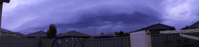
This was the monster approaching home from the North after tucker time..did it buckey down!!!
- I_Love_Storms
- Supercell
- Reactions:
- Posts: 2812
- Joined: Wed Dec 02, 2009 2:01 pm
- Location: Hawthorn
Re: Victoria: Low pressure system. March 4th-??? 2010
It's for heavy rain, I have seen similar warnings posted in SE QLD before. I think this one is a bit over the top to be honest though.
-
tizza
- Cumulonumbus Calvas
- Reactions:
- Posts: 728
- Joined: Wed Nov 25, 2009 6:48 pm
- Location: Dandenong North
- Contact:
Re: Victoria: Low pressure system. March 4th-??? 2010
Just heavy rain, possibly thundery. Covering their bases for flooding.Duckey wrote:Yeah what's with the red in the top right corner? Doesn't make sense to me either - is that meant to be some giant thunderstorm? Don't think so, the lightning tracker is showing that lightning's pretty much cleared most of the state except the far west. OddLeasy wrote:Duckley - the written info is old, especially about the 30mm in 30 mins in Mill Park, but the image is new.
Bit confused about the red in the top right hand corner - we should be under that and there isn't much rain!
Nice shot Mel
-
Duckey
- Cumulonimbus
- Reactions:
- Posts: 283
- Joined: Sun Mar 07, 2010 3:39 pm
- Location: Live: Croydon Work: Burwood
Re: Victoria: Low pressure system. March 4th-??? 2010
Thanks I_Love_Storms and Tizza The rain has just intensified here in the last minute, quite heavy. Still warm but not as muggy as it was earlier this evening
Storm Nerd!!
-
Petros

- Supercell
- Reactions:
- Posts: 2005
- Joined: Tue Dec 01, 2009 6:25 pm
- Location: Maffra, Gippsland, Vic
Re: Victoria: Low pressure system. March 4th-??? 2010
Leasy those Cicadas wouldnt be screeching from within the lawn (and shut up when you stand on them) would they?Leasy wrote:Cicadas going mental outside!! Rain has all but stopped for now, was very heavy before. If that was the last storm of the season then count me happy!
Still the same steady light rain here we've had for past 2 hrs, would have a look in the gauge but still CANTcatch up with the current posts in this forum!!! Maybe if all "it wont rain here" posts could be auto deleted it would be easier???
-
mick

- Supercell
- Reactions:
- Posts: 1453
- Joined: Mon Nov 30, 2009 6:45 pm
- Location: Mid North SA Baaaaaaaaaaaaaaa
Re: Victoria: Low pressure system. March 4th-??? 2010
All crickets here too.Petros wrote:Leasy those Cicadas wouldnt be screeching from within the lawn (and shut up when you stand on them) would they?Leasy wrote:Cicadas going mental outside!! Rain has all but stopped for now, was very heavy before. If that was the last storm of the season then count me happy!
Still the same steady light rain here we've had for past 2 hrs, would have a look in the gauge but still CANTcatch up with the current posts in this forum!!! Maybe if all "it wont rain here" posts could be auto deleted it would be easier???
-
Duckey
- Cumulonimbus
- Reactions:
- Posts: 283
- Joined: Sun Mar 07, 2010 3:39 pm
- Location: Live: Croydon Work: Burwood
Re: Victoria: Low pressure system. March 4th-??? 2010
Rain just got heavier again here - strange, as the radar shows it should be lessening up...but I say keep it coming!
Storm Nerd!!
- Scott Lawrance
- Cumulus
- Reactions:
- Posts: 84
- Joined: Thu Nov 26, 2009 9:13 am
- Location: Yea Victoria
- Contact:
Re: Victoria: Low pressure system. March 4th-??? 2010
Rain has passed us now here - but hope there s more to come and that we are just in a clear spot. More coming by the looks of the radar from up near Albury.
The Ghin Ghin Farmstore & Cafe
www.ghinghin.com.au
www.ghinghin.com.au
-
Duckey
- Cumulonimbus
- Reactions:
- Posts: 283
- Joined: Sun Mar 07, 2010 3:39 pm
- Location: Live: Croydon Work: Burwood
Re: Victoria: Low pressure system. March 4th-??? 2010
I spoke too soon LOL....rain just slowed to a drizzle... 
Storm Nerd!!
-
Petros
- Supercell
- Reactions:
- Posts: 2005
- Joined: Tue Dec 01, 2009 6:25 pm
- Location: Maffra, Gippsland, Vic
Re: Victoria: Low pressure system. March 4th-??? 2010
Yay caught up after 2 hrs chasing this thread. 
Rain stopped here 5 minus ago after a steady 2 hrs, expect 4mm but will get the torch and have a look in a minute.
As AV hinted, I think the SA cut-off is moving at last, imo due E so far, just into Vic W of Oyen. Anyone think it wont start sagging due S??
Great moisture now all over Vic - although the NE tilt will soon shadow us hugging the S side of the ranges.
- Skywalker
- Supercell
- Reactions:
- Posts: 1884
- Joined: Sun Nov 29, 2009 10:03 am
- Location: Burnside Heights/Cowes (Home) & Sunshine West (Work)
Re: Victoria: Low pressure system. March 4th-??? 2010
Just tipped 17mm out of the gauge here from tonights rain so far, event total now 70mm!
Caroline Springs, Melbourne's meteorological boredom zone.
-
Leasy
- Cumulonimbus
- Reactions:
- Posts: 216
- Joined: Wed Nov 25, 2009 6:50 pm
- Location: London, United Kingdom
Re: Victoria: Low pressure system. March 4th-??? 2010
Yeah, they are! Still going at it too!Petros wrote:Leasy those Cicadas wouldnt be screeching from within the lawn (and shut up when you stand on them) would they?Leasy wrote:Cicadas going mental outside!! Rain has all but stopped for now, was very heavy before. If that was the last storm of the season then count me happy!
Still the same steady light rain here we've had for past 2 hrs, would have a look in the gauge but still CANTcatch up with the current posts in this forum!!! Maybe if all "it wont rain here" posts could be auto deleted it would be easier???
-
Anthony Violi

- Supercell
- Reactions:
- Posts: 2652
- Joined: Mon Nov 23, 2009 9:03 pm
- Location: Lilydale
- Contact:
Re: Victoria: Low pressure system. March 4th-??? 2010
Another rainband forming behind this one, should ensure some more good falls through central areas overnight..
The low is starting make its move, but was expected to be near the west coast so models are a bit behind. Its track will determine another 50mm, or 5mm. Hopefully it pushes East a little more and gives Gippsland a soaking from the East as it drags its tail Southwards..
The low is starting make its move, but was expected to be near the west coast so models are a bit behind. Its track will determine another 50mm, or 5mm. Hopefully it pushes East a little more and gives Gippsland a soaking from the East as it drags its tail Southwards..
http://www.therealworldweatherforum.com" onclick="window.open(this.href);return false;
avweatherforecasts.com
avweatherforecasts.com