Welcome New Members! We want to hear from you. Register, stop lurking and start posting!
Strong front and cutoff low: May 20-25
- StratoBendigo
- Supercell
- Reactions:
- Posts: 2809
- Joined: Fri Jan 02, 2015 2:18 pm
- Location: Kangaroo Flat
Re: Strong front and cutoff low: May 20-25
33 mm this week in total. MTD is around 52mm (average for May). Perhaps a bit more later next week.
Classic cold and dreary winter's day today.
Classic cold and dreary winter's day today.
- Derwent
- Cumulonimbus
- Reactions:
- Posts: 119
- Joined: Tue Jul 09, 2019 10:44 am
- Location: Huonville Tasmania
Re: Strong front and cutoff low: May 20-25
Still looking likely to finish a very warm May month in Hobart. Still blocking Highs are ruining every opportunity for any decent rain. Looking like another crap Winter , dry and warm.
- Tassiedave
- Supercell
- Reactions:
- Posts: 1098
- Joined: Thu Nov 11, 2010 11:09 am
- Location: Grindelwald Tasmania
Re: Strong front and cutoff low: May 20-25
Great to have you on board Derwent. Two Tassies now! One from the north (Grindelwald) and one from the south!
- snowfall
- Supercell
- Reactions:
- Posts: 1283
- Joined: Mon Mar 20, 2017 7:39 pm
- Location: Gisborne South (349m asl)
Re: Strong front and cutoff low: May 20-25
Finished with 18.3mm in total since midnight. A great, occasionally showery day today. Seems to be generally clearing but there might be one or two light showers or drizzle to come. We’re just slightly under our May average now, with 56.8mm. Also tracking about one degree cooler for both maximum and minimum temps, which continues the trend since Feb.
- hillybilly
- Site Admin/Moderator
- Reactions:
- Posts: 4979
- Joined: Thu Nov 26, 2009 7:26 am
- Location: Howden Tasmania, 25m above sea level
- Contact:
Re: Strong front and cutoff low: May 20-25
Welcome Derwent. Just doubleD our Tas presence
Cold one in the Nongs with a max of just 7.5C. Proper cold
- Wilko
- Supercell
- Reactions:
- Posts: 1492
- Joined: Wed Aug 11, 2010 12:08 pm
- Location: Moorabbin & Highett, Vic
Re: Strong front and cutoff low: May 20-25
16mm O/Night
2 day total 30mm
2 day total 30mm
- phunkster
- Cumulus
- Reactions:
- Posts: 59
- Joined: Wed Oct 06, 2010 9:27 am
- Location: Werribe (H) / Notting Hill (W)
Re: Strong front and cutoff low: May 20-25
18mm for last two days in Werribee, can't complain about that at all. Echo the sentiments about JS, the lack of her presence has definitely been felt around here.
- hillybilly
- Site Admin/Moderator
- Reactions:
- Posts: 4979
- Joined: Thu Nov 26, 2009 7:26 am
- Location: Howden Tasmania, 25m above sea level
- Contact:
Re: Strong front and cutoff low: May 20-25
5mm in the gauge this morning. Ticking along nicely. City did well under a bay stream. It’s still on record pace for the YTD. To set a new January to end of May record it needs about 7mm more.
This system has one more round in it with showers thickening on Sunday. Could be locally 5-10mm more, but with southerly flow will tend to train so be hit and miss.
This system has one more round in it with showers thickening on Sunday. Could be locally 5-10mm more, but with southerly flow will tend to train so be hit and miss.
- snowfall
- Supercell
- Reactions:
- Posts: 1283
- Joined: Mon Mar 20, 2017 7:39 pm
- Location: Gisborne South (349m asl)
Re: Strong front and cutoff low: May 20-25
Dry overnight and a cool and cloudy day today. Max of 10.2c and a min of 4.7c.
Amazing mass of cloud over northern Australia for this time of year, stretching down into the ECL. The ECL is mostly impacting areas south of Sydney, so not quite the big falls that were originally forecast for Sydney today. Looking forward to maybe a bit of rain here tomorrow and Sunday with the southerly flow. Otherwise, looks like a bit of a wait for the next major system - maybe next weekend based on current models?
Amazing mass of cloud over northern Australia for this time of year, stretching down into the ECL. The ECL is mostly impacting areas south of Sydney, so not quite the big falls that were originally forecast for Sydney today. Looking forward to maybe a bit of rain here tomorrow and Sunday with the southerly flow. Otherwise, looks like a bit of a wait for the next major system - maybe next weekend based on current models?
- hillybilly
- Site Admin/Moderator
- Reactions:
- Posts: 4979
- Joined: Thu Nov 26, 2009 7:26 am
- Location: Howden Tasmania, 25m above sea level
- Contact:
Re: Strong front and cutoff low: May 20-25
Chilly max of 7.9C. More showers tomorrow as another trough pushes through.
Checkout out EC for Sunday night. Extraordinary system. Winds gusting over 150km/hr at sea level, big storm surge, big waves. This could be extremely damaging. Tides are high this weekend in WA. It pushes a surge our way later next week and we will get a gusty showery system likely around Thursday but nothing like that in WA.

Checkout out EC for Sunday night. Extraordinary system. Winds gusting over 150km/hr at sea level, big storm surge, big waves. This could be extremely damaging. Tides are high this weekend in WA. It pushes a surge our way later next week and we will get a gusty showery system likely around Thursday but nothing like that in WA.

- hillybilly
- Site Admin/Moderator
- Reactions:
- Posts: 4979
- Joined: Thu Nov 26, 2009 7:26 am
- Location: Howden Tasmania, 25m above sea level
- Contact:
Re: Strong front and cutoff low: May 20-25
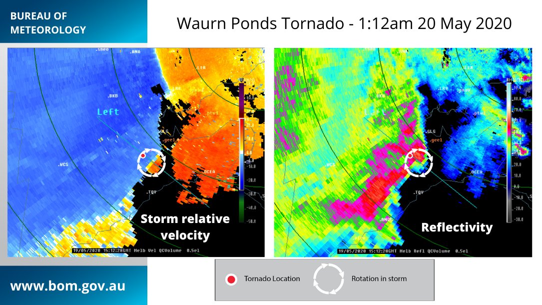
Btw here’s the report on the Geelong storm. Looks like a confirmed tornado.


- flyfisher
- Cumulonimbus
- Reactions:
- Posts: 250
- Joined: Wed Jul 18, 2012 1:39 pm
- Location: Belgrave
- Contact:
Re: Strong front and cutoff low: May 20-25
What a waste of a NW cloud band over the Tasman sea. Worst possible outcome now as we are sandwiched between two weather systems. We can have -IOD and LA Nina like conditions but if the weather systems don't play ball then you end up with this rubbish. It's the difference between a good season and a great one.
- snowfall
- Supercell
- Reactions:
- Posts: 1283
- Joined: Mon Mar 20, 2017 7:39 pm
- Location: Gisborne South (349m asl)
Re: Strong front and cutoff low: May 20-25
Yeah it's a shame the NW cloud band didn't get dragged down here, but given the current climate drivers there will be others to come. In the meantime, a bit of a stretch ahead of nothing too significant weather-wise. Models were toying with a significant cold outbreak next weekend, but not so much now.
Very grey, with fog and drizzle here this morning. 8c currently and 0.8mm.
Very grey, with fog and drizzle here this morning. 8c currently and 0.8mm.
- StratoBendigo
- Supercell
- Reactions:
- Posts: 2809
- Joined: Fri Jan 02, 2015 2:18 pm
- Location: Kangaroo Flat
Re: Strong front and cutoff low: May 20-25
It's not common in late-May for Brisbane to be warmer than Bendigo... Some crazy cold temps in Qld today.
- hillybilly
- Site Admin/Moderator
- Reactions:
- Posts: 4979
- Joined: Thu Nov 26, 2009 7:26 am
- Location: Howden Tasmania, 25m above sea level
- Contact:
Re: Strong front and cutoff low: May 20-25
Yep, crazy cold for them. It happens occasionally but rarely. Big cloud and rainband with a cold southerly blowing in underneath happens occasionally but many years don’t see it. Quite a few sites are touch and go for May records. 9am temps will come into play as it often warms up pretty quickly up there if the sun comes out tomorrow.StratoBendigo wrote: ↑Sat May 23, 2020 3:17 pm It's not common in late-May for Brisbane to be warmer than Bendigo... Some crazy cold temps in Qld today.
Cold foggy one up here with thick drizzle this arvo. Started to add up with 4mm so far, and falling thick atm. Makes over 50mm for the dates. MTD just shy of 120mm. We still need about 25mm to get our monthly total, as May is our westest month. Might get there, but think we will fall short. Shame as we have had a terrific year so far for rain.
Looks drizzly for another 12 to 24 hours. This is actually being fed by warm air advection with the upper trough/low to our west.
Meanwhile the WA low is deeper but a touch further west. EC has gust to 180km/hr over the oceans northwest of Perth and about 12 hours of gust around Perth in the 100 to 120km/hr range. This is looking serious. If it nudges further east it will be very bad. An intense Tropical Cyclone transition is extremely rare there.
- stevco123
- Supercell
- Reactions:
- Posts: 2936
- Joined: Sat Aug 07, 2010 7:42 pm
- Location: Cranbourne 78m asl
Re: Strong front and cutoff low: May 20-25
At this stage Rockhampton is having a maximum of 12.1 for today, which is the coldest maximum fit any month, ever. That 9am temp will be crucial tomorrow.
As at 11pm, it was 10 degrees there, compared to 12 in Melbourne!!!
Mackay had a maximum of 13.1 as well.
As at 11pm, it was 10 degrees there, compared to 12 in Melbourne!!!
Mackay had a maximum of 13.1 as well.
https://www.weatherlink.com/bulletin/53 ... 76dd68e8bc: for current weather updated every 2 minutes
- hillybilly
- Site Admin/Moderator
- Reactions:
- Posts: 4979
- Joined: Thu Nov 26, 2009 7:26 am
- Location: Howden Tasmania, 25m above sea level
- Contact:
Re: Strong front and cutoff low: May 20-25
Remarkable system. The night got chilly with mins widely in the 5-10C range which will be quite a shock for Queenslanders stretching well into the tropics. Now a race between the sun and 9am.stevco123 wrote: ↑Sat May 23, 2020 11:27 pm At this stage Rockhampton is having a maximum of 12.1 for today, which is the coldest maximum fit any month, ever. That 9am temp will be crucial tomorrow.
As at 11pm, it was 10 degrees there, compared to 12 in Melbourne!!!
Mackay had a maximum of 13.1 as well.
Thick fog up here all night with heavy drizzle at times. 12mm in the gauge. And locally up to nearly 15mm. There Is still one more trough to push through today which will see winds go from southsouthwest to southeast. Should thicken up showers for a period.
Then a longish mild spell with fronts peaking to our west. Maybe something late in the week.
- Gordon
- Supercell
- Reactions:
- Posts: 2888
- Joined: Thu Jun 17, 2010 10:01 am
- Location: Near Gordon, Vic. 620 m asl
Re: Strong front and cutoff low: May 20-25
We've just hit 30mm for these dates, thanks to 5.5mm of incessant drizzle over the last 24 hours - just won't give up! Also now ahead of our May average on 74mm.
(Just fascinating to see those QLD temps; wouldn't have thought it possible at those latitudes .)
.)
(Just fascinating to see those QLD temps; wouldn't have thought it possible at those latitudes
- stevco123
- Supercell
- Reactions:
- Posts: 2936
- Joined: Sat Aug 07, 2010 7:42 pm
- Location: Cranbourne 78m asl
Re: Strong front and cutoff low: May 20-25
Remarkable
https://www.weatherlink.com/bulletin/53 ... 76dd68e8bc: for current weather updated every 2 minutes
