Another huge high that takes a week or more to move through. This one is stuck in the bight and a bit further north so southeast Oz has mainly southerlies with some coastal showers for VIC, and better stream showers for TAS. It will get quite cold and with the high pressure will see some decent frosts.
Record dry and warmth out west with days of mid to high 20 for Perth.

Welcome New Members! We want to hear from you. Register, stop lurking and start posting!
Another huge high with days of southerlies: May 15-
Forum rules
When posting photos, particularly in active breaking weather threads, please link to clickable photos to minimise download issues. For more information, see Posting Photo Guidelines for more information. Threads that are six weeks old or older will be Archived Here
When posting photos, particularly in active breaking weather threads, please link to clickable photos to minimise download issues. For more information, see Posting Photo Guidelines for more information. Threads that are six weeks old or older will be Archived Here
-
hillybilly

- Site Admin/Moderator
- Reactions:
- Posts: 5041
- Joined: Thu Nov 26, 2009 7:26 am
- Location: Howden Tasmania, 25m above sea level
- Contact:
- StratoBendigo
- Supercell
- Reactions:
- Posts: 2841
- Joined: Fri Jan 02, 2015 2:18 pm
- Location: Kangaroo Flat
Another huge high with days of southerlies: May 15-
I can't really see any more rain this month. We were somewhat lucky on Friday night. Western Vic is in a dire state due to lack of rain-bearing cold fronts atm.
Not unprecedented though - I remember 1991 being quite similar. And then we had a very wet June.
Not unprecedented though - I remember 1991 being quite similar. And then we had a very wet June.
-
hillybilly
- Site Admin/Moderator
- Reactions:
- Posts: 5041
- Joined: Thu Nov 26, 2009 7:26 am
- Location: Howden Tasmania, 25m above sea level
- Contact:
Another huge high with days of southerlies: May 15-
Front here today with a pressure of 1018hPa. Getting a bit, but unfortunately mostly shredded by the ranges as happens when we are on the edge of the westerlies. Cold system but synoptic more typical of early autumn with big highs dominating.
TBH progs just keep getting worse. Last nights EC has basically zilch for nearly all of Oz next tend days, and GFS and GEM even less. While it’s only mid month, think we can call the warmest May on record for southwest WA, and Perth and Adelaide high chance of dries May on record. Seems to me that we haven’t had any proper lows and fronts in the westerlies for the best part of a year.
TBH progs just keep getting worse. Last nights EC has basically zilch for nearly all of Oz next tend days, and GFS and GEM even less. While it’s only mid month, think we can call the warmest May on record for southwest WA, and Perth and Adelaide high chance of dries May on record. Seems to me that we haven’t had any proper lows and fronts in the westerlies for the best part of a year.
Another huge high with days of southerlies: May 15-
My parents have lived in Perth all their lives and my dad was saying he has never known it to be so dry in May. It looks like mid summer, bare paddocks and days of 28-30c at their place in the Perth hills.
-
hillybilly
- Site Admin/Moderator
- Reactions:
- Posts: 5041
- Joined: Thu Nov 26, 2009 7:26 am
- Location: Howden Tasmania, 25m above sea level
- Contact:
Another huge high with days of southerlies: May 15-
Getting quite a polar blast here this arvo. Lots of coldies with brief thunder and graupel. Few spots in the hill have hade nearly 20mm which is handy. Dries out pretty quickly as one goes inland.
Expecting a seriously cold morning with lots of negatives, and will take a long while to warm up with almost winter sun. Nice to get a brief break from the highs.
WA is so far out of the record book it’s hard to make sense of it. Summer like temperatures and dry in why should be wet and cooler month. There forests are doomed if this keeps going. Massive die back already. Horrible situation.
-
hillybilly
- Site Admin/Moderator
- Reactions:
- Posts: 5041
- Joined: Thu Nov 26, 2009 7:26 am
- Location: Howden Tasmania, 25m above sea level
- Contact:
Another huge high with days of southerlies: May 15-
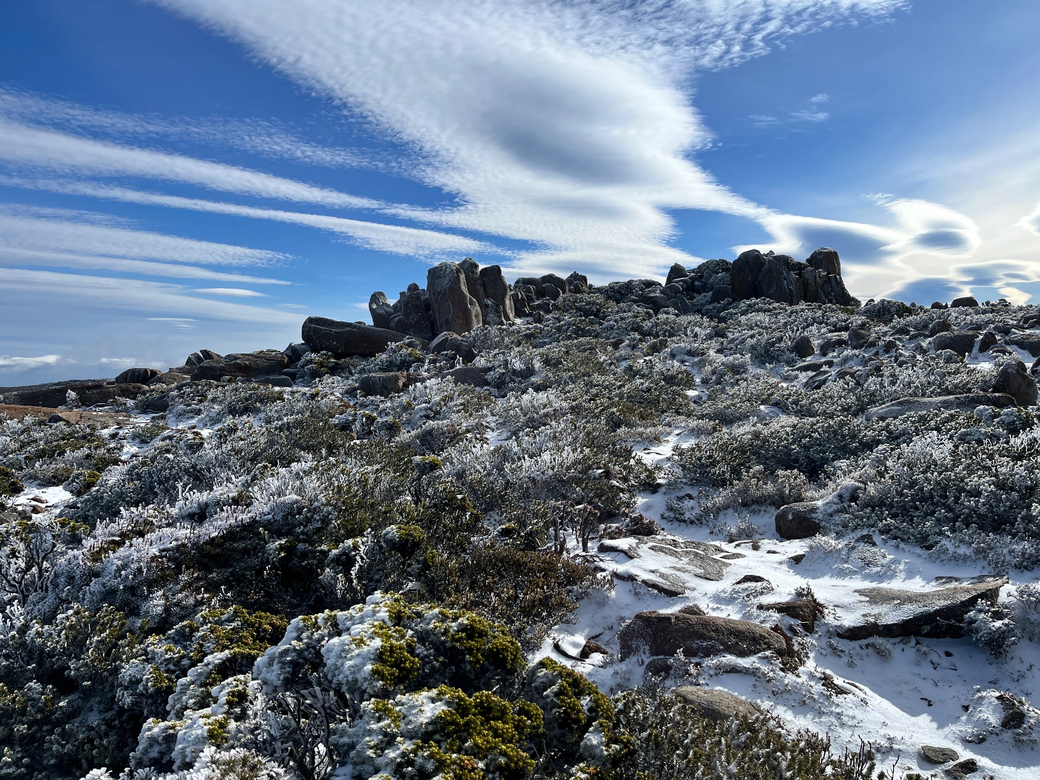
8mm in the gauge this morning. Clearing now with crisp 3C  off for a hike up the mountain this morning for a foot snow chase.
Progs suggesting we might get a decent east coast low around mid week. Quite liking the look of it. Looks to be mainly a TAS and eastern vic event.
Progs suggesting we might get a decent east coast low around mid week. Quite liking the look of it. Looks to be mainly a TAS and eastern vic event.

Another huge high with days of southerlies: May 15-
10mm here from yesterday’s showers. Makes our low May total a little less of an outlier.
- Macedonian
- Supercell
- Reactions:
- Posts: 2337
- Joined: Mon Dec 21, 2009 10:44 pm
- Location: Mount Macedon Vic at 870m above sea level
Another huge high with days of southerlies: May 15-
The switch has been flicked to winter overnight.
Min of 1.6° max of just 5.3° despite the sun all day. No going back now. Always happens in the third week of may.
Min of 1.6° max of just 5.3° despite the sun all day. No going back now. Always happens in the third week of may.
Home- "Shepherd's Bush" at Mt Macedon. 870m
Work- "Bolobek" at Macedon. 430m
Work- "Bolobek" at Macedon. 430m
- snowfall
- Supercell
- Reactions:
- Posts: 1301
- Joined: Mon Mar 20, 2017 7:39 pm
- Location: Gisborne South (349m asl)
Another huge high with days of southerlies: May 15-
Yep, felt like a standard winter day here as well, with a max of 10c. And a chilly 3c here currently.
We typically get an inversion on nights like this, so the temp may climb back up later, but shall see what happens. Otherwise, we could be in for a frost.
6mm here with the showers yesterday. Slowly creeping up for the monthly total, but it’s still on the drier side in what is a really bizarre May with barely any fronts.
-
hillybilly
- Site Admin/Moderator
- Reactions:
- Posts: 5041
- Joined: Thu Nov 26, 2009 7:26 am
- Location: Howden Tasmania, 25m above sea level
- Contact:
Another huge high with days of southerlies: May 15-
Good to see the tail end of the front scraping southern VIC. Not big totals but when the month has been so dry anything is very welcome.
Same front scarped western and far southern TAS with a few mm, but missed most the state.
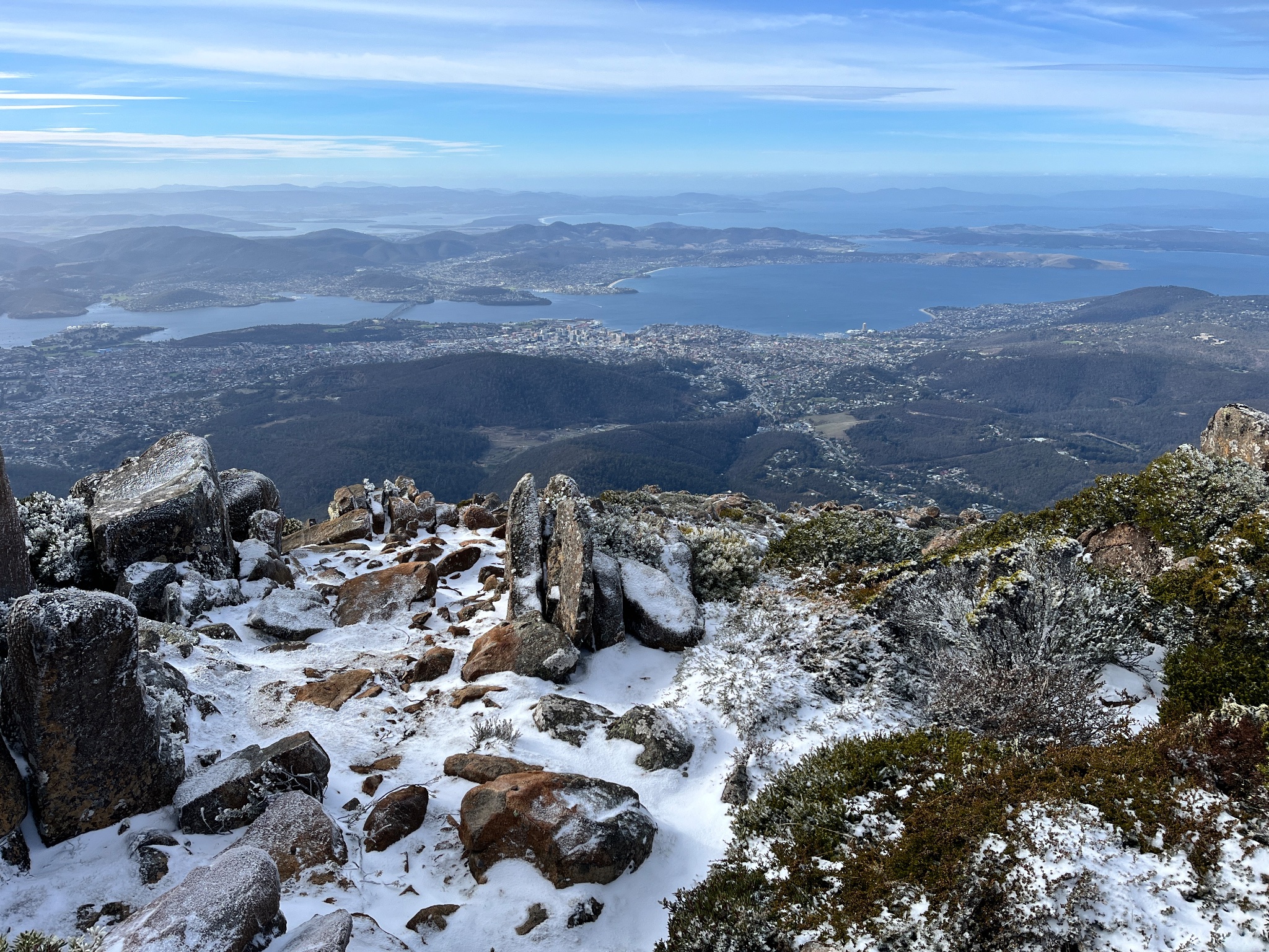
Managed to get up Kunanyi before the front. Just stunning. Was a crisp -3C at the time and calm after a few cm of snow,which was settled to about 600m.
Series of fronts for the week ahead sneaking around the big high. Bit hard to pick the totals, but mostly near coastal and light. Meanwhile Adelaide and Perth big dry continues

Same front scarped western and far southern TAS with a few mm, but missed most the state.
Managed to get up Kunanyi before the front. Just stunning. Was a crisp -3C at the time and calm after a few cm of snow,which was settled to about 600m.
Series of fronts for the week ahead sneaking around the big high. Bit hard to pick the totals, but mostly near coastal and light. Meanwhile Adelaide and Perth big dry continues
- snowfall
- Supercell
- Reactions:
- Posts: 1301
- Joined: Mon Mar 20, 2017 7:39 pm
- Location: Gisborne South (349m asl)
Another huge high with days of southerlies: May 15-
Grey, foggy and drizzly here since yesterday morning, with just a few mm. It's feeling very wintry though.
MTD is now 35mm. Will likely creep up a little more with the occasional showers this week, but otherwise on track for below average unfortunately.
MTD is now 35mm. Will likely creep up a little more with the occasional showers this week, but otherwise on track for below average unfortunately.
-
hillybilly
- Site Admin/Moderator
- Reactions:
- Posts: 5041
- Joined: Thu Nov 26, 2009 7:26 am
- Location: Howden Tasmania, 25m above sea level
- Contact:
Another huge high with days of southerlies: May 15-
Liking mid week here with a sneaky front through the high scenario. Otherwise highs, highs and more highs. Going off EC can lock in the driest May on record for lots of southern mainland Australia. Could also be driest on record for northwest Tasmania which is struggling because there has been basically no westerly fronts for weeks.
Would watch for possible June record warmth. Block continues until start of June and winds go more northerly. The Melbourne June record will eventually get broken by a lot as it dates back 60 years and we’ve seen about 1.5C of warming since then. Maybe not this year, but simply needs a stiff northerly set up start of June.
Would watch for possible June record warmth. Block continues until start of June and winds go more northerly. The Melbourne June record will eventually get broken by a lot as it dates back 60 years and we’ve seen about 1.5C of warming since then. Maybe not this year, but simply needs a stiff northerly set up start of June.
-
hillybilly
- Site Admin/Moderator
- Reactions:
- Posts: 5041
- Joined: Thu Nov 26, 2009 7:26 am
- Location: Howden Tasmania, 25m above sea level
- Contact:
Another huge high with days of southerlies: May 15-
Surprising band of rain here today. Pretty widespread 4-8mm so far. Is a warm front which is quite unusual to get one like this so close to the centre of a high. Hope it keeps raining.
Otherwise, most of Oz just sees high, highs and more highs.
Otherwise, most of Oz just sees high, highs and more highs.
- snowfall
- Supercell
- Reactions:
- Posts: 1301
- Joined: Mon Mar 20, 2017 7:39 pm
- Location: Gisborne South (349m asl)
Another huge high with days of southerlies: May 15-
Good to see at least some spots in Vic and Tas getting something in this otherwise very dry month.
5mm here yesterday, mainly overnight and morning from a persistent southerly stream of drizzle. Now we have about a week or so of very settled, dry weather ahead. Good conditions for any outdoor jobs, but we really do need some decent rain events again.
5mm here yesterday, mainly overnight and morning from a persistent southerly stream of drizzle. Now we have about a week or so of very settled, dry weather ahead. Good conditions for any outdoor jobs, but we really do need some decent rain events again.
-
hillybilly
- Site Admin/Moderator
- Reactions:
- Posts: 5041
- Joined: Thu Nov 26, 2009 7:26 am
- Location: Howden Tasmania, 25m above sea level
- Contact:
Another huge high with days of southerlies: May 15-
Rainband pushing up through the high scenario for eastern Tas today. Could be quite heavy in the northeast where the system stalls for 12 hours. Might yet get to average this month despite no strong fronts.
Rest of Oz just having highs highs and more highs. Things will start to move a bit come next week with the highs pushing north and east. Will allow fronts to start to clip WA, TAS and maybe coastal parts of SA and VIC. Watching for some really mild air to push in from around this time next week.
Rest of Oz just having highs highs and more highs. Things will start to move a bit come next week with the highs pushing north and east. Will allow fronts to start to clip WA, TAS and maybe coastal parts of SA and VIC. Watching for some really mild air to push in from around this time next week.
- StratoBendigo
- Supercell
- Reactions:
- Posts: 2841
- Joined: Fri Jan 02, 2015 2:18 pm
- Location: Kangaroo Flat
Another huge high with days of southerlies: May 15-
Endless days of clear skies and frost & dew each morning....
Something might happen around May 30th with a NW rainband perhaps?
Something might happen around May 30th with a NW rainband perhaps?
- Gordon
- Supercell
- Reactions:
- Posts: 2907
- Joined: Thu Jun 17, 2010 10:01 am
- Location: Near Gordon, Vic. 620 m asl
Another huge high with days of southerlies: May 15-
Yep, feels like something wants to give around the end of the week. Models bouncing around all over the place, but at least most now have half decent totals... most of the time.StratoBendigo wrote: ↑Thu May 23, 2024 10:13 am Something might happen around May 30th with a NW rainband perhaps?
Meanwhile, at Mt Read in western Tassie, another 18mm yesterday to bring their mtd to 188mm. Nice to know it can still rain somewhere
-
hillybilly
- Site Admin/Moderator
- Reactions:
- Posts: 5041
- Joined: Thu Nov 26, 2009 7:26 am
- Location: Howden Tasmania, 25m above sea level
- Contact:
Another huge high with days of southerlies: May 15-
Back to highs here. Looks like we are gonna finish the month with almost average rain, but unfortunately going to fall short. That will make five months in a row Things have greened up but moisture is quite shallow.
With the high getting frosts with 2C yesterday and 1C here today. Thinking around 2C for tomorrow so touch and go for our third frost in a row.
With the high getting frosts with 2C yesterday and 1C here today. Thinking around 2C for tomorrow so touch and go for our third frost in a row.
-
hillybilly
- Site Admin/Moderator
- Reactions:
- Posts: 5041
- Joined: Thu Nov 26, 2009 7:26 am
- Location: Howden Tasmania, 25m above sea level
- Contact:
Another huge high with days of southerlies: May 15-
Cracking white frost here this morning. Nice sunny day ahead.
Finally looks like a system to talk about with a strong front around Thursday and Friday. Should produce quite widespread moderate falls across southern South Australia, most of Victoria, NSW and TAS. Should sneak in just before the end of the month. Not much cold air with it, so snow will be pretty minimal.
Finally looks like a system to talk about with a strong front around Thursday and Friday. Should produce quite widespread moderate falls across southern South Australia, most of Victoria, NSW and TAS. Should sneak in just before the end of the month. Not much cold air with it, so snow will be pretty minimal.
- StratoBendigo
- Supercell
- Reactions:
- Posts: 2841
- Joined: Fri Jan 02, 2015 2:18 pm
- Location: Kangaroo Flat
Another huge high with days of southerlies: May 15-
-1c frost this morning. Decent for May.
I can't see much rain later in the week. Perhaps 5-10mm?
I can't see much rain later in the week. Perhaps 5-10mm?