This weekend will start to put together all the model analysis and discuss the upcoming Spring/Summer for the IOD.
Needless to say at this point my forecast is poles apart from the official ones.
Feel free to discuss or add any info you like.

Welcome New Members! We want to hear from you. Register, stop lurking and start posting!
2012/2013 IOD
-
Anthony Violi

- Supercell
- Reactions:
- Posts: 2652
- Joined: Mon Nov 23, 2009 9:03 pm
- Location: Lilydale
- Contact:
2012/2013 IOD
http://www.therealworldweatherforum.com" onclick="window.open(this.href);return false;
avweatherforecasts.com
avweatherforecasts.com
-
Anthony Violi
- Supercell
- Reactions:
- Posts: 2652
- Joined: Mon Nov 23, 2009 9:03 pm
- Location: Lilydale
- Contact:
Re: 2012/2013 IOD
JAmstec now going for a negative IOD this Summer, right in line with my forecasts.
most other models have a weak positive event.
Jamstec outlook.

CFS for the next 3 months shows plenty of frontal systems with a negative AAO coming into play.

But then in the summer, CFS really starts ramping up rainfall confirming a negative IOD is becoming more likely.

Also note that its forecasting very dry condtions across the top end.
Temps are forecast to cool for the next nine months as well, correlating well with more cloud cover.

So in summary, im expecting a negative IOD through Summer.
Cooler than average until March 2013, and very much above average rainfall until March as well.
El nino will be weak and barely noticeable, which is not unusual in a cold PDO.
This just reinforces what i mean, an EL Nino normally wouldnt have this sort of forecast on the East Coast for summer.

most other models have a weak positive event.
Jamstec outlook.
CFS for the next 3 months shows plenty of frontal systems with a negative AAO coming into play.
But then in the summer, CFS really starts ramping up rainfall confirming a negative IOD is becoming more likely.
Also note that its forecasting very dry condtions across the top end.
Temps are forecast to cool for the next nine months as well, correlating well with more cloud cover.
So in summary, im expecting a negative IOD through Summer.
Cooler than average until March 2013, and very much above average rainfall until March as well.
El nino will be weak and barely noticeable, which is not unusual in a cold PDO.
This just reinforces what i mean, an EL Nino normally wouldnt have this sort of forecast on the East Coast for summer.
http://www.therealworldweatherforum.com" onclick="window.open(this.href);return false;
avweatherforecasts.com
avweatherforecasts.com
-
crikey

- Supercell
- Reactions:
- Posts: 1314
- Joined: Mon Feb 07, 2011 8:02 pm
- Location: tweed shire NSW and nDUNOLLY.. Nth Central district VIC
- Contact:
Re: 2012/2013 IOD
What about the extremely strong dry anomalies at the top end
You would think the monsoon is not coming? or tropical cyclones?
Isn't that an El Nino signal up,there
I gather a neg IOD is good for southern latitude rainfall.?
Do you have any stats'/links on that AV? for those like me who would like to begin to read up a little
You would think the monsoon is not coming?
Isn't that an El Nino signal up,there
I gather a neg IOD is good for southern latitude rainfall.?
Do you have any stats'/links on that AV? for those like me who would like to begin to read up a little
-
Anthony Violi
- Supercell
- Reactions:
- Posts: 2652
- Joined: Mon Nov 23, 2009 9:03 pm
- Location: Lilydale
- Contact:
Re: 2012/2013 IOD
Yes Crikey negative IOD is great for rainfall from the NW cloudbands with very warm water off our NW WA coast.
The main thing is the flow turns SE and drags down enormous moisture from thr tropics and sends it down across the Southern half of Australia.
The top end signals i do not agree with, its going for a strong El nino which has no chance of forming.
Next 4 weeks will tell, but i have always said warm neutral, but our weather is tending La nina again.
Also note that CFS has massive rainfall for the QLD coast in the late spring/summer, something you wouldnt see in an El Nino usually.
Trades are still easterly so CFS is having a bet both ways, but i couldnt see that top end forecast coming off.
Bizzare thing regarding the IOD is something i have been going on about for the last 12 months, since the last one finished and the IOD went weak positive, all the moisture from Indonesia is being funnelled into the Central Indian ocean and then down into the Westerlies from there, so its still been finding its way too us for the last 9 months or so and giving us above average falls.
This is where the game changes, Cold PDo climates are different to warm ones, and the climate behaves differently. We are seeing this the last couple of years and will only continue.
http://www.therealworldweatherforum.com" onclick="window.open(this.href);return false;
avweatherforecasts.com
avweatherforecasts.com
- Gordon
- Supercell
- Reactions:
- Posts: 2887
- Joined: Thu Jun 17, 2010 10:01 am
- Location: Near Gordon, Vic. 620 m asl
Re: 2012/2013 IOD
Crikey this is an interesting little link: http://www.bom.gov.au/climate/IOD/negative/" onclick="window.open(this.href);return false;crikey » Sun Jul 08, 2012 10:30 pm wrote:crikey wrote:What about the extremely strong dry anomalies at the top end
You would think the monsoon is not coming?
Isn't that an El Nino signal up,there
I gather a neg IOD is good for southern latitude rainfall.?
Do you have any stats'/links on that AV? for those like me who would like to begin to read up a little
-
crikey
- Supercell
- Reactions:
- Posts: 1314
- Joined: Mon Feb 07, 2011 8:02 pm
- Location: tweed shire NSW and nDUNOLLY.. Nth Central district VIC
- Contact:
Re: 2012/2013 IOD
Yes thankyou Gordon it is a great link.. I don't know much at all about IOD so relying on you 'guys' commentary for now.. I'm spending time delving into the enso atm
amongst other interests
I did read from that link ,that a neg IOD and el nino are very uncommon together,with only one year when this has happened in recent past
so yeah .when is the IOD phase locked in for a pos or a neg?
Which month? How long is the IOD cycle?
amongst other interests
I did read from that link ,that a neg IOD and el nino are very uncommon together,with only one year when this has happened in recent past
so yeah .when is the IOD phase locked in for a pos or a neg?
Which month? How long is the IOD cycle?
-
Anthony Violi
- Supercell
- Reactions:
- Posts: 2652
- Joined: Mon Nov 23, 2009 9:03 pm
- Location: Lilydale
- Contact:
Re: 2012/2013 IOD
Yeah not all that often they happen together Crikey.
1074/74 was one, 2010/11 was the big one.
However its the cold PDO thats impacting the systems. it is indeed the Earths thermostat, but more, its a driver.
You can see the pic from Jamstec up above, showing warm water building from Sept onwards.
here is the write up they had with it..
June 14, 2012 (notes updated June 19, 2012)
ENSO forecast: Although there is still a warm sea surface temperature anomaly near the eastern boundary of the basin, it will disappear by boreal fall and the neutral state will come back. It will continue at least until spring of the next year.
Indian Ocean forecast: A negative Indian Ocean Dipole mode will develop in boreal summer and then peak in fall. Warmer-than-normal sea surface temperature will persist west of Australia in following seasons.
Regional forecast: Most parts of the globe except Canada, Alaska, and Australia will experience warmer-than-normal climate in boreal summer. In boreal winter, it will be colder-than-normal in most parts of Eurasian continent.
Most part of Africa will have warmer-than-normal climate in borealfall.
Northeast China, Korea, and Japan will have relatively less rain in Baiu/Meiu/Chagma season; this may be due to the evolution of the negative IOD and related suppressed convective activities (dry conditions) over the Indo-China Peninisula. Persistence of the abnormally strong Okhotsk high may be also responsible for this.
We are afraid that warmer and drier than normal conditions will continue in East Africa and India from boreal summer to fall owing to the negative IOD.
Australia and Brazil will be relatively colder and wetter than normal in austral spring.
BAck to my point about the PDo, it appears there might be a link to the SAM and the IOD. Im going to research it as the climate atm is behaving very strangely and is tilted sharply at cooler and wetter for us the last 3 years and for the foreseeablefuture.
http://www.therealworldweatherforum.com" onclick="window.open(this.href);return false;
avweatherforecasts.com
avweatherforecasts.com
-
crikey
- Supercell
- Reactions:
- Posts: 1314
- Joined: Mon Feb 07, 2011 8:02 pm
- Location: tweed shire NSW and nDUNOLLY.. Nth Central district VIC
- Contact:
Re: 2012/2013 IOD
Thanks for posting that from JAMSTEC...AV,
will be good to see how their prediction fairs.
Re your comment
the climate atm is behaving very strangely and is tilted sharply at cooler and wetter for us the last 3 years and for the foreseeable future.
A potential lead also for you to follow regarding climate shift since 2000 and climate shift for melbourne around late 2009
Since the 2000 climate shift and associated change in phase of PDO
I noticed that the pattern between the northern and southern hemisphere temp anomalies began to appear to change phase
so that when Nth Hemisphere temps peak ( probably july) the southern hemisphere temps were going inverse and peaking at a cold anomaly at the same time
So what l am saying is the sth and nth hemispheres not in temp sync from 2000
In fact are inverse during peak in nth hemisphere summer
I saw this trend is some data from 2000 to 2006 but can't find some later data from 2006-2012 that compares sth hemisphere and nth hemisphere anomalies graphed together to see if this change of phase is continuing?
Anyone know where l can get this? ( graphed anomalies overlayed and compared for nth and sth hemisphere global temps)
Look forward to read how your research develops and what you find AV
-
Anthony Violi
- Supercell
- Reactions:
- Posts: 2652
- Joined: Mon Nov 23, 2009 9:03 pm
- Location: Lilydale
- Contact:
Re: 2012/2013 IOD
Thats actually quite normal IMO crikey, the AMO is still warm for the next few years. And in La Ninas, the USA is warm. In an El Nino they are in the fridge, we are warm.
What i meant was the fact that you can tell the MSLP are different, no doubt about it. The troughs are being drawn further South because the highs are doing the same, but when the SAM goes negative it rides cold air over the top of the high to interact with tropical moisture, which is extraordinary and not something i have seen much off before. Almost like the highs are on the surface with a trough aloft.
And because most of us were not around from the 1940s to 70s it makes it hard to compare if its all part of the shift or something more significant is going on.
http://www.therealworldweatherforum.com" onclick="window.open(this.href);return false;
avweatherforecasts.com
avweatherforecasts.com
-
crikey
- Supercell
- Reactions:
- Posts: 1314
- Joined: Mon Feb 07, 2011 8:02 pm
- Location: tweed shire NSW and nDUNOLLY.. Nth Central district VIC
- Contact:
Re: 2012/2013 IOD
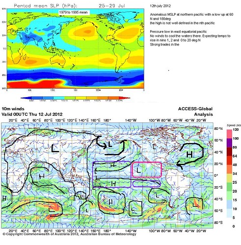
Maybe this mean MSLP global animation might assist you AV.
It goes from 1979 to 1995 .
From the animation it shows that during that time period above ( pre 2000)
the high pressure belt beginning to contract south in late July but mostly around (spring) september
So if you feel the high pressure belt is dropping out earlier then maybe that signifies an earlier transition . That would likely indicate an earlier spring as the low pressure area moves down over the northern top end as well at the same time
If you look at the animation you will see what l am referring to
Maybe that explains the anomalously humid conditions in the NT this winter.
Maybe the high pressure belt has dropped down south a little early this year.
Certainly last year the NT and QLD largely had negative dew point around this time last year.
For your perusal anyway
Pentad Mean Sea Level Pressure Banner 1979 to 1995
http://www.cpc.ncep.noaa.gov/products/p ... ploop.html" onclick="window.open(this.href);return false;
-
Anthony Violi
- Supercell
- Reactions:
- Posts: 2652
- Joined: Mon Nov 23, 2009 9:03 pm
- Location: Lilydale
- Contact:
Re: 2012/2013 IOD
Yeah its definitely done that, question is what drives the move?
These moves dont happen overnight it takes years, a very gradual shift.
thats why this period of the world climate is going to be so critical as a reference point.
These moves dont happen overnight it takes years, a very gradual shift.
thats why this period of the world climate is going to be so critical as a reference point.
http://www.therealworldweatherforum.com" onclick="window.open(this.href);return false;
avweatherforecasts.com
avweatherforecasts.com
-
crikey
- Supercell
- Reactions:
- Posts: 1314
- Joined: Mon Feb 07, 2011 8:02 pm
- Location: tweed shire NSW and nDUNOLLY.. Nth Central district VIC
- Contact:
Re: 2012/2013 IOD
Oh l see you are referring to climate shift trends( Interdecadal l think they call it)
I thought you meant annual variation
Well there's a few theories going around as you would know..
The first hurdle to overcome is deciding how much of the climate shift is overlayered harmonic cycles ( destructive /constructive interference) and how much is the chaos theory..
Myself l believe in harmonics, cycles and order.. When there are multiple frequencies involved and they overlay. The overall pattern looks chaotic
The challenge is to, identify the frequencies,separate each of the frequencies and determine their period.
Overlay them all and it would be evident that at some points in time the signal overlap or the amplitude increases ( constructive interference) and sometimes the frequency opposes and can cancel each other out to some extent or to all extent
It is a large task to separate each and understand how they interact with each other
However l agree with what you say in that a la nina , cool Pdo and declining solar activity together are 3 frequencies that produce a constructive effect and causes amplification of that wet cool signal
You would imagine that whilst the SAM remains in mean positive anomaly
and if the polar vortex remains strong etc we will not tend to cool wet
To be cold and wet we would really on the polar and sub polar patterns l would have thought..
Antartica sea ice is increasing maybe this has something to do with position of westerly belt?
Also the temperature gradient between the Nth and south pole is increasing
and the temp gradient between the stratosphere and the troposphere is increasing
Spatial pattern of temp across the globe both vertically and horizontally would have a lot to do with it l would imagine.
What do you think is the cause atm?
Oh by the way . I have been mapping the global synoptics lately
Take what you want from this if at all
I did notice the polar high pressure belt appears to be anonymously south atm
and check out that incursion of low pressure drooping down from Asia which is completely out of place for JULY. accounting for low pressure and moisture high dew points in the dry season up north.
and the high anomaly south of India probably affecting their monsoon
and the nth atlantic high is very west and equatorial atm for july and the low above it is emerging early...
Not sure if those anonalies are annual or a shift associated with 2000 climate shift.
It would take a lot of study and sleepless nights to work that out.
cheers
-
Anthony Violi
- Supercell
- Reactions:
- Posts: 2652
- Joined: Mon Nov 23, 2009 9:03 pm
- Location: Lilydale
- Contact:
Re: 2012/2013 IOD
So many questions ans so few answers.
I wouldn't worry about sleepless nights Crikey will take decades or centuries to find the answer, simply because we operate in decadal cycles, some 4,5 and 6 decades long.
The most fascinating thing about the pattern is that the warm PDO climate shift began in the late 70s, yet the cyclical change to our weather patterns in Australia didn't really begin until the early 90s.
And now we had a decade of neutral PDO until 2007 when the shift took place, now it's firmly cold PDO, yet our patterns are still going the opposite way, as if there is a lag effect. We saw the lag after the cold PDO, now we are seeing one with the warm PDO. And you could summize that another decade of this sort of climate would see us massively on the cool wet side, with the troughs from the north much further south.
So while all this is interesting, my belief is the cold PDO is the main driver, if you look at 1998 EL Niño it was like a last gasp massive release of heat.. Most of the oceans were extremely warm, and ever since its slowly declined so that each El Niño isn't anywhere near that level.
Solar also has an impact, and with solar max next year, then a decline after that, there is a 7 year lag effect. Some people subscribe to the theory the ocean cycles coincide with the sun, but I don't believe so, solar is definitely a driver though but more to do with solar irradiance.
Anyway, back on topic, Jamstec will update their outlooks next week, the Sst subsurface in the Indian have a lot of warm water underneath the surface that should start to appear in about 6-8 weeks. Will post it once it's online.
Just quickly one last thought, PDO is cold, AMO is going to turn cold by 2016, and solar minimum is in 2017...and solar cycle 25 is expected to be non existent....if that all turns out that way, good luck I say.
http://www.therealworldweatherforum.com" onclick="window.open(this.href);return false;
avweatherforecasts.com
avweatherforecasts.com
-
crikey
- Supercell
- Reactions:
- Posts: 1314
- Joined: Mon Feb 07, 2011 8:02 pm
- Location: tweed shire NSW and nDUNOLLY.. Nth Central district VIC
- Contact:
Re: 2012/2013 IOD
Re the timing of PDO change of phase
According to this graph below it depends on whether you view the commencement of new PDO cycle as from its peak ( max ) around 1981/82 or whether you view the commencement of the new phase in 2000 where the PDO was in neutral(0))
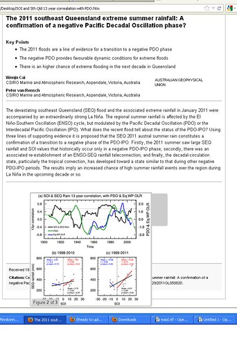
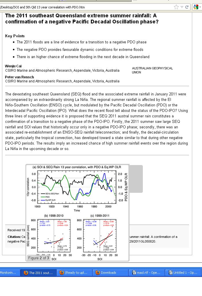
for eq PDO outgoing long wave radiation as per this article by Cai and Rensch ( 2011?)posted below
They have an example of one phase of the PDO being 40 yrs; 1940 to 1980
and one being 20 years at 1910 to 1930
So at least 2 frequencies( causes..) interacting
So somehow the PDO is related to OLR ( outgoing longwave radiation)?
I find it interesting that when PDO is trending pos, SOI is trending neg
an inverse relationship.
pulled this snap from my archives re PDO cycle
link to larger image here
http://farm8.staticflickr.com/7224/7350 ... e992_b.jpg" onclick="window.open(this.href);return false;
Anyway off the thread topic soo...
Does the IOD cycle with the PDO?
Do you have a thread in climate ,on oscillations and cycles AV?
According to this graph below it depends on whether you view the commencement of new PDO cycle as from its peak ( max ) around 1981/82 or whether you view the commencement of the new phase in 2000 where the PDO was in neutral(0))
for eq PDO outgoing long wave radiation as per this article by Cai and Rensch ( 2011?)posted below
They have an example of one phase of the PDO being 40 yrs; 1940 to 1980
and one being 20 years at 1910 to 1930
So at least 2 frequencies( causes..) interacting
So somehow the PDO is related to OLR ( outgoing longwave radiation)?
I find it interesting that when PDO is trending pos, SOI is trending neg
an inverse relationship.
pulled this snap from my archives re PDO cycle
link to larger image here
http://farm8.staticflickr.com/7224/7350 ... e992_b.jpg" onclick="window.open(this.href);return false;
Anyway off the thread topic soo...
Does the IOD cycle with the PDO?
Do you have a thread in climate ,on oscillations and cycles AV?
-
Karl Lijnders

- Tornadic Supercell
- Reactions:
- Posts: 5771
- Joined: Sun Nov 22, 2009 11:17 pm
- Location: Knoxfield, Victoria
Re: 2012/2013 IOD
Thanks Crikey for all the incredible posts on here. Really interesting stuff!! 
Former Owner - The Australian Weather Forum. Email me anytime - weatherman1000@hotmail.com
-
Karl Lijnders
- Tornadic Supercell
- Reactions:
- Posts: 5771
- Joined: Sun Nov 22, 2009 11:17 pm
- Location: Knoxfield, Victoria
Re: 2012/2013 IOD
Looks like the Indian Ocean is on the warm which is inline with seasonal prospects.
Something to watch over coming weeks as it could mean rainfall is drawn from this region for our spring and summer.
Something to watch over coming weeks as it could mean rainfall is drawn from this region for our spring and summer.
Former Owner - The Australian Weather Forum. Email me anytime - weatherman1000@hotmail.com
-
Anthony Violi
- Supercell
- Reactions:
- Posts: 2652
- Joined: Mon Nov 23, 2009 9:03 pm
- Location: Lilydale
- Contact:
Re: 2012/2013 IOD
And importantly the link between cold PDO and our weather is very evident.
At the moment the atmosphere is decoupled from the Ocean...and it wont possibly go into any semblance of El Nino.
The cold PDO is chewing up the subsurface..and you will see in a few months that climate models are so geared towards the Co2 myth that they cant see it coming when i saw it coming 3 years in advance.
If anything, we are lucky we have had a positive IOD since Autumn, as we have now had nearly the whole years average again and could have been destroyed by now, even though we are on a knifes edge anyway.
Still expecting a negative IOD to develop, and further records to be broken this summer, in line with a monsoon that will be the polar opposite of last year and come in early, and spend much of the time in southern states.
Next 6 weeks will set the scene for the upcoming Oct-Mar period.
http://www.therealworldweatherforum.com" onclick="window.open(this.href);return false;
avweatherforecasts.com
avweatherforecasts.com
Re: 2012/2013 IOD
Coral sea is cooling now too, starting to look like your more typical traditional El Nino/Positive IOD set up now even if El Nino is weak but the fact the Coral sea has cooled and theres been warming near the Dateline is starting to really show that now. Yes Southern Vic has been wet the past 4 months but Northern Vic/Southern NSW and WA and most of SA have seen below average rainfall and now that the coral sea has cooled I can't see that changing anytime soon. Southern Vic may be ok if we continue to get good fronts but Southern Vic only makes a very small portion of Southern and SE Australia.
Re: 2012/2013 IOD
http://weather.unisys.com/surface/sst_anom.gif" onclick="window.open(this.href);return false;
- Monbulkian
- Cumulonimbus
- Reactions:
- Posts: 192
- Joined: Thu Nov 11, 2010 9:42 pm
- Location: Monbulk
Re: 2012/2013 IOD
Not very good at posting links. An article i found on my phone news update is talking about warmer and drier weather and that we face a high fire risk this summer and farmers concerned for their crops. http://m.brisbanetimes.com.au/environme ... 23mnb.html" onclick="window.open(this.href);return false;. Thought it might tie in with what you have been talking about here and also how the bom have a different interpretation of weather data and how it impacts farmers etc. If it is not relevant feel free to delete this post or if you can find the article from the information i have given you post a suitable link.
Last edited by Monbulkian on Sun Aug 05, 2012 7:01 pm, edited 1 time in total.