
Welcome New Members! We want to hear from you. Register, stop lurking and start posting!
VIC - Low pressure sequence. 24–31 May 2019
- Macedonian
- Supercell
- Reactions:
- Posts: 2330
- Joined: Mon Dec 21, 2009 10:44 pm
- Location: Mount Macedon Vic at 870m above sea level
Re: Low pressure sequence. 24–31 May
Jeez i hope you get that 1.5 ☺
Home- "Shepherd's Bush" at Mt Macedon. 870m
Work- "Bolobek" at Macedon. 430m
Work- "Bolobek" at Macedon. 430m
- BringOnTheCoolChange
- Cumulonimbus
- Reactions:
- Posts: 216
- Joined: Fri Jul 18, 2014 9:27 pm
- Location: East Warburton, Victoria, asl 232m
Re: Low pressure sequence. 24–31 May
Not my pic, but a pic earlier this morning from Warburton Primary school

- snowfall
- Supercell
- Reactions:
- Posts: 1283
- Joined: Mon Mar 20, 2017 7:39 pm
- Location: Gisborne South (349m asl)
Re: Low pressure sequence. 24–31 May
Yes, the projected probabilities from Access-S were quite a long way off. Though the problem with representing the forecast as probabilities is that the BOM is technically not wrong, as they’ve still indicated ‘some’ chance of at least 50mm. The big issue is, as you’ve pointed out JS, that it would seem not all variables are factored in, which creates additional error and therefore to be taken with quite a large grain of salt.
2mm here overnight and today, taking us to 32mm for the thread and 98.8mm MTD. We’re very close to the 100mm mark, but not sure if we’ll quite make it. Still quite cool, but not as cold as yesterday. We maxed out at 9.8c with a low of 3.5c. Currently 7.9c, windchill 4c, and some light drizzle.
2mm here overnight and today, taking us to 32mm for the thread and 98.8mm MTD. We’re very close to the 100mm mark, but not sure if we’ll quite make it. Still quite cool, but not as cold as yesterday. We maxed out at 9.8c with a low of 3.5c. Currently 7.9c, windchill 4c, and some light drizzle.
-
hillybilly

- Site Admin/Moderator
- Reactions:
- Posts: 4979
- Joined: Thu Nov 26, 2009 7:26 am
- Location: Howden Tasmania, 25m above sea level
- Contact:
Re: Low pressure sequence. 24–31 May
Surprised you've never cracked the double ton Gordon. We usually get that about once a year. My best in the past ten years is just shy of 400mm. Must admit my love of wet can be tested in those sort of months
The Dandenongs drizzle machine is now cranking with the warm air advection SWly flow kicking in. Nearly 7mm since I emptied the gauge this morning, and nice and thick now. They are really hard to predict as tiny changes in the flow and height to the inversion can make a big difference, but wouldn't surprise if we scored 10-20mm overnight now. A nice wintery max of 6C for us.
This drizzle will wash a fair bit of the snow away at the southern resorts. Wouldn't be surprised if Lake Mt, Baw Baw and Donna Buang get a fair wash out the next 36 hours.
-
hillybilly
- Site Admin/Moderator
- Reactions:
- Posts: 4979
- Joined: Thu Nov 26, 2009 7:26 am
- Location: Howden Tasmania, 25m above sea level
- Contact:
Re: Low pressure sequence. 24–31 May
Bit of a distraction, but there's a bit of confusion about what the monthly and seasonal forecast show. They tell you how the climate drivers are influencing the outcome. ATM we have a near El Nino and a positive IOD (and global warming). The natural drivers weight the odds towards poor rainfall in southern and eastern Australia. This signal in autumn is not strong (the above/below median odds were about 40%:60% for May in central Vic). This doesn't mean it will be dry (Victoria got very lucky with a single heavy fall event early in the month which set the stage for the above average falls).snowfall wrote: ↑Thu May 30, 2019 5:30 pm Yes, the projected probabilities from Access-S were quite a long way off. Though the problem with representing the forecast as probabilities is that the BOM is technically not wrong, as they’ve still indicated ‘some’ chance of at least 50mm. The big issue is, as you’ve pointed out JS, that it would seem not all variables are factored in, which creates additional error and therefore to be taken with quite a large grain of salt.
You can't predict individual weather events more than about 10 days into the future, so the individual extreme events can't be captured. The inability to capture these is not because of poor models, but because small uncertainty in models grow quickly and eventually overwhelm the forecast signal. Models will only get better with time, so they will become more certain and more accurate.
I look at May and thank our lucky stars. The climate odds are weighted against us, but we got lucky. That luck sits in the ~40% probability of above average. Unfortunately, those west of these stubborn highs have had the reverse luck and experience record heat and near record or record dry
There's a saying that you should use the forecast to "know which way to lean, rather than which way to jump".
- JasmineStorm
- Supercell
- Reactions:
- Posts: 1870
- Joined: Thu Sep 22, 2016 9:40 pm
- Location: Kyneton 527 ASL
Re: Low pressure sequence. 24–31 May
EC ensemble must of got lucky for May as well 
- Attachments
-
- EC ensemble 25 April.jpg (308.09 KiB) Viewed 11596 times
- Horts
- Cumulonimbus
- Reactions:
- Posts: 238
- Joined: Mon Sep 26, 2016 12:25 pm
- Location: Safety Beach (Home) / Mount Waverley (Work) / Cowes (Beach House)
Re: Low pressure sequence. 24–31 May
Non stop drizzle to steady rain for about 3 hours on the southern end of the peninsula. Has not stopped once. Absolutely drenched. Exactly what we needed this is awesome. Good stuff!
Light enough to appear patchy on the radar but it's constant, by the looks of it still a few more hours to go
Light enough to appear patchy on the radar but it's constant, by the looks of it still a few more hours to go
-
hillybilly
- Site Admin/Moderator
- Reactions:
- Posts: 4979
- Joined: Thu Nov 26, 2009 7:26 am
- Location: Howden Tasmania, 25m above sea level
- Contact:
Re: Low pressure sequence. 24–31 May
That looks like a 40 day forecast? Maybe I’m reading it wrong.
- Gordon
- Supercell
- Reactions:
- Posts: 2888
- Joined: Thu Jun 17, 2010 10:01 am
- Location: Near Gordon, Vic. 620 m asl
Re: Low pressure sequence. 24–31 May
Yes the closest we came until now was 2011: 198mm in Jan; 189.5mm in Feb.hillybilly wrote: ↑Thu May 30, 2019 5:56 pm Surprised you've never cracked the double ton Gordon. We usually get that about once a year. My best in the past ten years is just shy of 400mm. Must admit my love of wet can be tested in those sort of months
Came home just now to another 3.5mm so we have a new record of 199mm
- JasmineStorm
- Supercell
- Reactions:
- Posts: 1870
- Joined: Thu Sep 22, 2016 9:40 pm
- Location: Kyneton 527 ASL
Re: Low pressure sequence. 24–31 May
Gordon wrote: ↑Thu May 30, 2019 7:52 pmYes the closest we came until now was 2011: 198mm in Jan; 189.5mm in Feb.hillybilly wrote: ↑Thu May 30, 2019 5:56 pm Surprised you've never cracked the double ton Gordon. We usually get that about once a year. My best in the past ten years is just shy of 400mm. Must admit my love of wet can be tested in those sort of months
Came home just now to another 3.5mm so we have a new record of 199mm
- JasmineStorm
- Supercell
- Reactions:
- Posts: 1870
- Joined: Thu Sep 22, 2016 9:40 pm
- Location: Kyneton 527 ASL
Re: Low pressure sequence. 24–31 May
Yep, 46 day ensemble. It has included the important cyclic climatic factors for Vic of the MJO phase and the negative SAM. It's earlier runs before these indicators became apparent were bleak for rainfall in May.hillybilly wrote: ↑Thu May 30, 2019 7:41 pmThat looks like a 40 day forecast? Maybe I’m reading it wrong.
-
hillybilly
- Site Admin/Moderator
- Reactions:
- Posts: 4979
- Joined: Thu Nov 26, 2009 7:26 am
- Location: Howden Tasmania, 25m above sea level
- Contact:
Re: Low pressure sequence. 24–31 May
That would make it a below average forecast also. I’d expect most or all climate models to pick up on the IOD and ENSO signals and lean towards dry overall.JasmineStorm wrote: ↑Thu May 30, 2019 8:40 pmYep, 46 day ensemble. It has included the important cyclic climatic factors for Vic of the MJO phase and the negative SAM. It's earlier runs before these indicators became apparent were bleak for rainfall in May.hillybilly wrote: ↑Thu May 30, 2019 7:41 pmThat looks like a 40 day forecast? Maybe I’m reading it wrong.
-
hillybilly
- Site Admin/Moderator
- Reactions:
- Posts: 4979
- Joined: Thu Nov 26, 2009 7:26 am
- Location: Howden Tasmania, 25m above sea level
- Contact:
Re: Low pressure sequence. 24–31 May
Drizzle coming down in buckets up here now and humidity sat on 100%. The cloud base tonight has dropped to about 150m so the low level upslide with the capping at 10,000 feet is setting up a very efficient “warm rain producer”. GFS has it continuing for 24-36 hours. These sets ups are really hard to predict but this should add up through the eastern burbs through Yarra Ranges. We’ve now had 9mm since ~9am and currently falling at 3mm/hr. Just 4mm to our monthly average so should get there...
- JasmineStorm
- Supercell
- Reactions:
- Posts: 1870
- Joined: Thu Sep 22, 2016 9:40 pm
- Location: Kyneton 527 ASL
Re: Low pressure sequence. 24–31 May
The original Access S post is about the threshold of 50mm. Nothing to do with mean or average.hillybilly wrote: ↑Thu May 30, 2019 9:12 pmThat would make it a below average forecast also. I’d expect most or all climate models to pick up on the IOD and ENSO signals and lean towards dry overall.JasmineStorm wrote: ↑Thu May 30, 2019 8:40 pmYep, 46 day ensemble. It has included the important cyclic climatic factors for Vic of the MJO phase and the negative SAM. It's earlier runs before these indicators became apparent were bleak for rainfall in May.hillybilly wrote: ↑Thu May 30, 2019 7:41 pm
That looks like a 40 day forecast? Maybe I’m reading it wrong.
-
hillybilly
- Site Admin/Moderator
- Reactions:
- Posts: 4979
- Joined: Thu Nov 26, 2009 7:26 am
- Location: Howden Tasmania, 25m above sea level
- Contact:
Re: Low pressure sequence. 24–31 May
It’s the same. ACCESS-S forecasts derive that 50mm probability using the likelihood of above and below median. Multiple that EC map by 2/3rd and most areas will be less than 50mm, and below average. They show the same thing.JasmineStorm wrote: ↑Thu May 30, 2019 9:40 pm
The original Access S post is about the threshold of 50mm. Nothing to do with mean or average.
New outlook out, shows southern Vic on the edge of the IOD/ENSO drying signal for the next two months. Hoping that this means we continue to get these showery rainfall events and maybe sneak average or better
-
hillybilly
- Site Admin/Moderator
- Reactions:
- Posts: 4979
- Joined: Thu Nov 26, 2009 7:26 am
- Location: Howden Tasmania, 25m above sea level
- Contact:
Re: Low pressure sequence. 24–31 May
18mm more in the gauge this morning and still coming down thick. We’ve just cracked 80mm for the event and 150mm for the month, making our first above average for the year  Is it greedy to ask to get another 20mm before it clears tomorrow to give us a 100mm system
  (and jump start June).
Quite mild here overnight with a rising temperature. Now up to 8C and still going up. Classic winter warm air advection. Type of event that really benefits the Dandenongs. Looking forward to getting out on the weekend into the forest to see it all nice a soggy. Will also make a quick run down to Walkerville, and will be interesting how it looks after nearly 150mm in the past week.
Frustratingly, city looks stuck 4mm below average so another miss. That’s five months in a row
Btw here’s the latest snow depths for the event. Pretty much sets up the two big resorts now until spring, unless they get a big warm rain event. Baw Baw and Lake Mt will have lost a fair bit last night, and will loose more today.
Hotham 48cm
Baw Baw 45cm
Falls Ck 44cm
Stirling 40cm
Buller 30cm
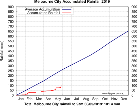
Btw here’s the Melbourne rainfall accumulation. Eek
 Hard to imagine that little rain in a five month period. We’ve had about 350mm which is well below average. Usually we get about double the city, so getting 3-4 times is pretty unusual and shows how bad the central parts of the city have done.
Quite mild here overnight with a rising temperature. Now up to 8C and still going up. Classic winter warm air advection. Type of event that really benefits the Dandenongs. Looking forward to getting out on the weekend into the forest to see it all nice a soggy. Will also make a quick run down to Walkerville, and will be interesting how it looks after nearly 150mm in the past week.
Frustratingly, city looks stuck 4mm below average so another miss. That’s five months in a row
Btw here’s the latest snow depths for the event. Pretty much sets up the two big resorts now until spring, unless they get a big warm rain event. Baw Baw and Lake Mt will have lost a fair bit last night, and will loose more today.
Hotham 48cm
Baw Baw 45cm
Falls Ck 44cm
Stirling 40cm
Buller 30cm
Btw here’s the Melbourne rainfall accumulation. Eek
- JasmineStorm
- Supercell
- Reactions:
- Posts: 1870
- Joined: Thu Sep 22, 2016 9:40 pm
- Location: Kyneton 527 ASL
Re: Low pressure sequence. 24–31 May
Another 4mm in the last 24 hours here get its up to 117mm MTD. Nearly 2 inches above the May mean and the highest May rainfall for nearly 3 decades. Those lucky climate indicators of MJO and SAM...... I just can't believe my luck 
- Gordon
- Supercell
- Reactions:
- Posts: 2888
- Joined: Thu Jun 17, 2010 10:01 am
- Location: Near Gordon, Vic. 620 m asl
Re: Low pressure sequence. 24–31 May
Well what a month! Our coldest May max. since 2000, our best May snowfall since 2000, and with another 5.5mm to 9am, our wettest month (any month) in 22 years here: 201 mm! A barely believable turnaround from our driest Jan-April, when just 62mm fell.
Still puts us a bit behind (263mm ytd) our end of May average of 283mm, but remarkable to be even close thanks to over 8 inches of rain in a month.
Still puts us a bit behind (263mm ytd) our end of May average of 283mm, but remarkable to be even close thanks to over 8 inches of rain in a month.
- stevco123
- Supercell
- Reactions:
- Posts: 2936
- Joined: Sat Aug 07, 2010 7:42 pm
- Location: Cranbourne 78m asl
Re: Low pressure sequence. 24–31 May
Just under 80mm here for the month.
90mm in Cranbourne East
90mm in Cranbourne East
https://www.weatherlink.com/bulletin/53 ... 76dd68e8bc: for current weather updated every 2 minutes
- Dane
- Supercell
- Reactions:
- Posts: 1661
- Joined: Thu Nov 26, 2009 9:51 am
- Location: Sebastopol 420m ASL
- Contact:
Re: Low pressure sequence. 24–31 May
4.8mm's up to 9am giving me a monthly total of 168.2mm's.
Ballarat Airport was on the lighter end of things this month with 138.4mm's
most of Ballarat PWS are showing 150 to 180mm's this month.
Still that 138.4mm's makes it the wettest May since 1960 - 172.7mm's.
Average is only 64mm's so well over double the average.
Despite the cold finish to the month temperatures are pretty close to average for May