The models are still dancing around the possibility of storms, but there is enough data to suggest that Friday and Saturday are a reasonable chance of storms around SA/VIC & NSW.
I will post the pre-event analysis from Towering Updraft before continuing.

Welcome New Members! We want to hear from you. Register, stop lurking and start posting!
SE Australia: Possible storms: 29/10 to 1/11
-
Blackee

- Site Admin/Moderator
- Reactions:
- Posts: 3859
- Joined: Tue Nov 24, 2009 8:57 pm
- Location: Elwood and Mansfield 370m
SE Australia: Possible storms: 29/10 to 1/11
Mansfield 370m and Elwood
-
Blackee
- Site Admin/Moderator
- Reactions:
- Posts: 3859
- Joined: Tue Nov 24, 2009 8:57 pm
- Location: Elwood and Mansfield 370m
Re: SE Australia: Possible storms: 29/10 to 1/11
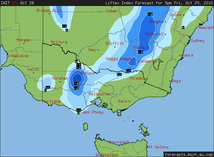
12z Lifted Index chart for 1700hrs Friday, 29/10
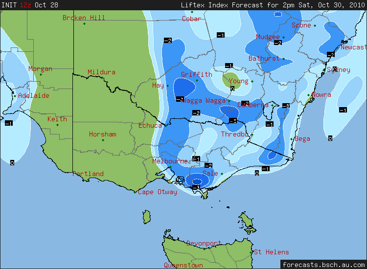
12z Lifted Index chart for 1400hrs Saturday, 30/10
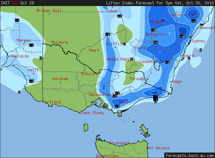
12z Lifted Index chart for 1700hrs Saturday, 30/10
12z Lifted Index chart for 1400hrs Saturday, 30/10
12z Lifted Index chart for 1700hrs Saturday, 30/10
Mansfield 370m and Elwood
-
Blackee
- Site Admin/Moderator
- Reactions:
- Posts: 3859
- Joined: Tue Nov 24, 2009 8:57 pm
- Location: Elwood and Mansfield 370m
Re: SE Australia: Possible storms: 29/10 to 1/11
06Z Stormcast holds for some opportunity out west this afternoon.
1700hrs forecast is very similar to the 12Z, with LI's to -4, especially around the Charlton/St Arnaud area.
CAPE levels are poor, so I'll wait til the soundings and BOM charts avail themselves!
1700hrs forecast is very similar to the 12Z, with LI's to -4, especially around the Charlton/St Arnaud area.
CAPE levels are poor, so I'll wait til the soundings and BOM charts avail themselves!
Mansfield 370m and Elwood
Re: SE Australia: Possible storms: 29/10 to 1/11
I posted this in the breaking forum, but it's gone ignored in the midst of all of the "omg it's raining" posts.
Whilst playing cricket at Menzies Creek today I noticed a seriously structured cell that appeared to have inflow, and some rotation develop over in the Cardinia Dam direction, though it was much further away. I estimate 20ish km. It threw the odd cc, I'd have seen atleast six in the period I watched it. Obviously I couldn't photograph it given I was playing cricket. John, if you read this, you might recall the other night there was a dying cell to the N/NW that I was asking questions about, I described it as a "tendril" and asked if the tendril breaking up was because it was weakening. Anyhow, this "tendril" on this cell would have been at the very least four times the size and very close to the ground. Eventually it was sucked up into the cloud.
The ground is across the road from here;
http://maps.google.com.au/maps?f=q&sour ... 15&iwloc=A
I noticed the development fielding at Cover when the bowling was coming from the Black Hill Road end, over a period from around 1.15-1.45.
After looking at the maps I estimate that the area inbetween Hampton Park & Patterson Lakes is of interest at around this time.
If anyone could take a look at the radar or doppler and let me know if there was anything of interest in the region, at the time I'm estimating I'd be most appreciative.
Since I posted, I've tried to draw a diagram. Wish I had photos.
- Hamlan
- Storm Chaser
- Reactions:
- Posts: 449
- Joined: Tue Dec 22, 2009 11:05 pm
- Location: Northern suburbs
Re: SE Australia: Possible storms: 29/10 to 1/11
Good work Ryan, being observant is awesome. Agree it sounds from your description that it may have been an inflow feature and from the sounds of it, a low one. Shame radar doesnt offer some explanation to help. I have seen small but rapidly developing cells pull inflow and organise fractus into some low level features so it does happen. Good stuff. Does a camera fit in your cricket pants? haha
Brad.
Brad.
Re: SE Australia: Possible storms: 29/10 to 1/11
I'm trying to pinpoint the location exactly with Google earth as we speak. It's a bit tricky, because I can't tell how tall the trees are. But I'm up there next week, so I'll take a shot or two of the gap & area I'm talking about. I'm beginning to think it was perhaps further East. But I'll keep you in the loop. It sure was an amazing sight as it was going on, several others noted & mentioned it..
-
Karl Lijnders

- Tornadic Supercell
- Reactions:
- Posts: 5771
- Joined: Sun Nov 22, 2009 11:17 pm
- Location: Knoxfield, Victoria
Re: SE Australia: Possible storms: 29/10 to 1/11
From what I saw at that time it was more of a roll cloud and outflow boundary from the SW wind shift. But again I could be wrong but there was nothing particularly interesting from what I could see along the line at that time.
But I did happen to see some raggered structure on the convergent band as it was over the western suburbs at around 1pm. Looked ominous.
But I did happen to see some raggered structure on the convergent band as it was over the western suburbs at around 1pm. Looked ominous.
Former Owner - The Australian Weather Forum. Email me anytime - weatherman1000@hotmail.com
Re: SE Australia: Possible storms: 29/10 to 1/11
Karl, you're spot on in terms of the timing. I'm almost sure it's when the wind was changing, difficult to be 100% as the ground is pretty much surrounded in high trees. However, I'm talking about the SE Burbs, I couldn't see West. Or - are you suggesting you saw it in the West and it moved over? I'm not quite sure I follow..
-
Karl Lijnders
- Tornadic Supercell
- Reactions:
- Posts: 5771
- Joined: Sun Nov 22, 2009 11:17 pm
- Location: Knoxfield, Victoria
Re: SE Australia: Possible storms: 29/10 to 1/11
That convergence band was in the western sky from 1pm and gradually swept across over 3hrs. Only came into view as it neared within 10km.
What you saw was later than what I saw in the west and a seperate cycle.
What you saw was later than what I saw in the west and a seperate cycle.
Former Owner - The Australian Weather Forum. Email me anytime - weatherman1000@hotmail.com
-
Blackee
- Site Admin/Moderator
- Reactions:
- Posts: 3859
- Joined: Tue Nov 24, 2009 8:57 pm
- Location: Elwood and Mansfield 370m
Re: SE Australia: Possible storms: 29/10 to 1/11
An impressive storm John, now another just NE of Dungog is probably more organised than the previous cell.
Mansfield 370m and Elwood
Re: SE Australia: Possible storms: 29/10 to 1/11
The cross-section imagery (below) taken through that cell near Dungog shows just how healthy that storm is with an impressive overhang. The other thing that stands out is the big hail spike radiating outwards to the NW (caused by the radar beam bouncing back and forth between the large hailstones and taking longer to return to the radar):

- Twister
- Cumulonumbus Calvas
- Reactions:
- Posts: 914
- Joined: Sun Nov 29, 2009 10:47 pm
- Location: Brisbane Qld
Re: SE Australia: Possible storms: 29/10 to 1/11
Oh wow those radar scans are impressive that hail spike is almost text book very impressive, Big storms up there today radar looks unreal
Now Living in Wet QLD
-
Blackee
- Site Admin/Moderator
- Reactions:
- Posts: 3859
- Joined: Tue Nov 24, 2009 8:57 pm
- Location: Elwood and Mansfield 370m
Re: SE Australia: Possible storms: 29/10 to 1/11
WOW, brilliant imagery Ken!
This SC is very slow moving and not being absorbed by the surrounding shower/rain activity.
Warning to all residents of Booral, Girvan, Allworth, Nugra,Nelson Bay & Lemon Tree Passage, NSW. An extremely severe thunderstorm is approaching your area.
It is currently around the township of Stroud, and travelling SSE. Very large hail likely.
Mansfield 370m and Elwood
- I_Love_Storms
- Supercell
- Reactions:
- Posts: 2812
- Joined: Wed Dec 02, 2009 2:01 pm
- Location: Hawthorn
Re: SE Australia: Possible storms: 29/10 to 1/11
WOW, great stuff. Looks hectic up there.

Re: SE Australia: Possible storms: 29/10 to 1/11
That thing has a black core for over two hours. And followed up by another one full of black that lasts an hour or so.Lily wrote:Woah! Big storms! http://radar.strikeone.net.au/?fuseacti ... 1288589400
-
brayden

- Cumulonimbus
- Reactions:
- Posts: 225
- Joined: Thu Dec 31, 2009 9:54 am
- Location: Perth. Originally Wodonga, Vic
Re: SE Australia: Possible storms: 29/10 to 1/11
Noice!  Thanks for the cross section Ken, looks delicious! One big rain mass now
"I'm in with the sane, does that make me Insane?"
"I lycra like that"
"I lycra like that"