
Welcome New Members! We want to hear from you. Register, stop lurking and start posting!
VIC: Rain/showers & thunderstorms - October 12th- 14th
Re: VIC: Rain/showers & thunderstorms - October 12th- 14th
We have had a few little showers already this morning .5mm rain and just starting again.13c.
-
Karl Lijnders

- Tornadic Supercell
- Reactions:
- Posts: 5771
- Joined: Sun Nov 22, 2009 11:17 pm
- Location: Knoxfield, Victoria
Re: VIC: Rain/showers & thunderstorms - October 12th- 14th
It appears the model waltz continues with 3 main areas of weather to come through now. Today looks quite good for wet storms and quite a few convective showers that will all flatten to rain later on tonight. Should see some heavy falls develop tonight along the divide and near and east of the trough through C areas.
Tomorrow the rainfall will continue through C and E areas with locally heavy falls and thunderstorms. That focus will contract slightly to the N and E as a front and cold air start to move in from the SW during Thursday.
During Thursday we could see a major outbreak of rain and storms in response to the front and cold moving into the warm and humid airmass over the state. Should see falls of 20-30mm widespread with frequent showers, hail and thunderstorms to follow and snow line dropping.
The low pressure system that was progged earlier in the week could still come off for the weekend. Saturday and Sunday look showery as the low bombs and travels SE of VIC.
I am anticipating ~50-100mm for the sequence here. Could be well more close by to the east and northeast and any tilt or stalling in the trough will make a marked difference.
Get the lawn mowers ready next week!
Former Owner - The Australian Weather Forum. Email me anytime - weatherman1000@hotmail.com
-
Karl Lijnders
- Tornadic Supercell
- Reactions:
- Posts: 5771
- Joined: Sun Nov 22, 2009 11:17 pm
- Location: Knoxfield, Victoria
Re: VIC: Rain/showers & thunderstorms - October 12th- 14th
It has not been a lean October. It is 12 days old and many areas of the south have had 30-50mm of rain from last week.... 
Anyhow 40mm from the first burst and 30-40mm from the second should wrap up the averages across southern VIC.
And then we got next week too. Suddenly October not looking so lean, might need to visit Jenny Craig come Halloween!!
Anyhow 40mm from the first burst and 30-40mm from the second should wrap up the averages across southern VIC.
And then we got next week too. Suddenly October not looking so lean, might need to visit Jenny Craig come Halloween!!
Former Owner - The Australian Weather Forum. Email me anytime - weatherman1000@hotmail.com
-
Anthony Violi

- Supercell
- Reactions:
- Posts: 2652
- Joined: Mon Nov 23, 2009 9:03 pm
- Location: Lilydale
- Contact:
Re: VIC: Rain/showers & thunderstorms - October 12th- 14th
Back it in, big falls coming. When we get to day 12 and it's panic stations, the last 3 times we have been slaughtered. This will be no different, averages will be accomplished with 10 days to spare..
http://www.therealworldweatherforum.com" onclick="window.open(this.href);return false;
avweatherforecasts.com
avweatherforecasts.com
Re: VIC: Rain/showers & thunderstorms - October 12th- 14th
My lastest thoughts on the State forecast..
All models have an upper trough with moisture from the NW and a surface trough slowly edging eastwards Today with a band of rain and isolated storms developing over Western Victoria Tuesday ahead of this band expect humid unstable NE/N winds from Queensland to develop Scattered showers and few storms ahead of the main band itself manly Central and Eastern Victoria. Humid N winds will dominate most the day but expect a SW to S change to sneak into SW Victoria Tuesday pushing through South Central parts at night.
Wednesday: Areas of rain will continue for alot of the state but clearing slowly from the West, Isolated storms mainly Central, Northern and Eastern areas solid falls will occur as the Upper trough and surface trough will almost stagnate over Victoria on Wednesday. Humid NE to NW winds East and North of the surface trough and SW to SE winds West of the surface trough, with those SW to SE winds also expect drizzle and fog on higher ground to develop in the very moist conditions.
Thursday: Rain and isolated storms contracting into far Eastern Victoria with drizzle and scattered showers to continue on the ranges but as the front approaches expect showers and thunderstorms to develop from the West and NW late in the day then move Eastwards and tend to thundery rain areas from the West. Lighter winds at first tending quite humid NW to NE ahead of a colder SW change on the Western border in the evening.
Friday: Cold SSW winds will continue with areas of rain in the morning with locally heavy falls in Central, NE and Eastern areas at first contracting into Gippsland, widespread showers & local hail and thunder will follow, showers be more scattered in the North. Snow may also falls to as low as 700 metres during Friday.
Saturday: Showers mainly contracting to Southern and mountain areas and easing from the West. Local hail at first in the SE. Fresh gusty SW winds slowly easing.
The models waltz dance continues so keep an eye on any adjustment guys.
-
Karl Lijnders
- Tornadic Supercell
- Reactions:
- Posts: 5771
- Joined: Sun Nov 22, 2009 11:17 pm
- Location: Knoxfield, Victoria
Re: VIC: Rain/showers & thunderstorms - October 12th- 14th
Looking OK for rainfall. Sky is filling fast with mid level towers and there are widespread showers, tending to rain about the ranges in C and E VIC.
Thundery rain moving into the SW.
In the slot between the two is where the mid level storms should fire from this afternoon, but lots of cloud will mean not too photogenic and hard to pin point from the naked eye without radar assistance.
Otherwise an exciting period of weather!!
Thundery rain moving into the SW.
In the slot between the two is where the mid level storms should fire from this afternoon, but lots of cloud will mean not too photogenic and hard to pin point from the naked eye without radar assistance.
Otherwise an exciting period of weather!!
Former Owner - The Australian Weather Forum. Email me anytime - weatherman1000@hotmail.com
-
Karl Lijnders
- Tornadic Supercell
- Reactions:
- Posts: 5771
- Joined: Sun Nov 22, 2009 11:17 pm
- Location: Knoxfield, Victoria
Re: VIC: Rain/showers & thunderstorms - October 12th- 14th
Starting to get a convective signature in the rainband in the SW coast presently and the showers over the divide also starting to get a little pulsey.
Otherwise US holds and generally increases rainfall on average across the state.
Otherwise US holds and generally increases rainfall on average across the state.
Former Owner - The Australian Weather Forum. Email me anytime - weatherman1000@hotmail.com
- Harley34
- Cumulonumbus Calvas
- Reactions:
- Posts: 580
- Joined: Sat Mar 06, 2010 1:08 pm
- Location: Ringwood East, Melbourne
Re: VIC: Rain/showers & thunderstorms - October 12th- 14th
Need this cloud to move, if we want to see anything decent! Nice looking rainband hitting the SA/VIC border at the moment. My impression is we won't see anything spectacular today, but perhaps tomorrow. Like Karl mentioned, those showers are starting to look pulsey, and these could very well hit a higher intensity soon, if a few things play out. Forecast from the BOM today is 24 C. Can't reaaaally see that happening, but cloud could clear later on..I'm thinking more of a 22 C day today at the most, but i may be wrong. I'm also starting to like the look of Thursday's front. I have to agree that the whole state will be under a warm and humid airmass, and as cold air hits the boundaries, we should see some nice storms develop from the W. Not really feeling this cold outbreak later in the week, as i thought we were well passed the stage of temperatures as low as predicted, but October can really throw up anything. We really haven't hit the peak of the storm season. I would not mind at all if we picked up a large amount of rainfall within the next few days, without any storms.
Anyway, W VIC still looks favourable this afternoon.
Anyway, W VIC still looks favourable this afternoon.
-
Karl Lijnders
- Tornadic Supercell
- Reactions:
- Posts: 5771
- Joined: Sun Nov 22, 2009 11:17 pm
- Location: Knoxfield, Victoria
Re: VIC: Rain/showers & thunderstorms - October 12th- 14th
Nothing supercellular today, but storms are storms and I think they will be fun once they develop.
Can see glaciation and full cj deck across the north and northwest sky. There is a clear slot to our north and I anticipate around 24C is a good temp this afternoon.
Can see glaciation and full cj deck across the north and northwest sky. There is a clear slot to our north and I anticipate around 24C is a good temp this afternoon.
Former Owner - The Australian Weather Forum. Email me anytime - weatherman1000@hotmail.com
- AmaroK
- Cumulonimbus
- Reactions:
- Posts: 186
- Joined: Thu Nov 26, 2009 6:23 pm
- Location: Home Lysterfield....Work Bayswater.
Re: VIC: Rain/showers & thunderstorms - October 12th- 14th
Some very interesting mid level structures out there at the moment. Definitely looking like some good water later this evening. Had a few power fluctuations in the office today, but didn't think the wind was quite strong enough to cause that. Expecting heat to play a big part in what action we get later today, sitting just over 20degrees here in bayswater, and still warming up. Not bad for a day with quite a fair bit of cloud cover.
Jason: The Token Weather Noob
-
Blackee

- Site Admin/Moderator
- Reactions:
- Posts: 3857
- Joined: Tue Nov 24, 2009 8:57 pm
- Location: Elwood and Mansfield 370m
Re: VIC: Rain/showers & thunderstorms - October 12th- 14th
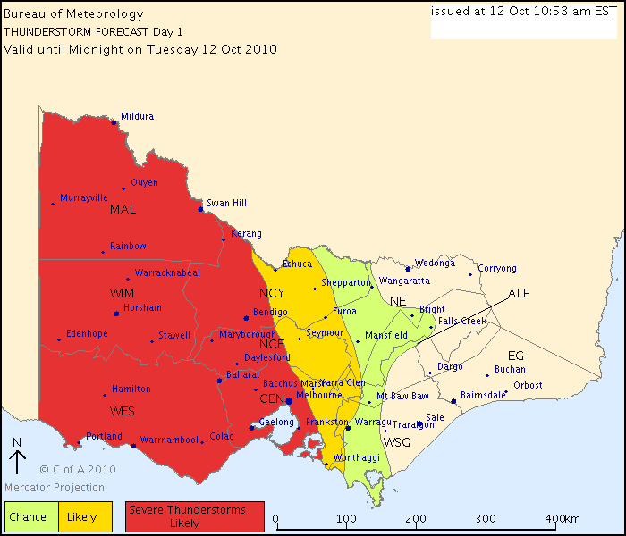
THUNDERSTORM FORECAST
Issued at 10:53 am Tuesday, 12 October 2010,
Valid until midnight on Tuesday, 12 October 2010.
A warm, humid and unstable airmass with a low pressure trough in the far
southwest moving to a position near Mildura to Melbourne at around midnight. Any
thunderstorm activity should be near the trough and flash flooding is likely
while large hail and strong winds are possible.
Mansfield 370m and Elwood
- adon
- Cumulonumbus Calvas
- Reactions:
- Posts: 681
- Joined: Wed Dec 09, 2009 12:50 pm
- Location: Birchip NW Vic
Re: VIC: Rain/showers & thunderstorms - October 12th- 14th
Got some convection starting off here but nothing spectacular.
- Nick Sykes
- Cumulonimbus
- Reactions:
- Posts: 353
- Joined: Wed Nov 25, 2009 6:16 pm
- Location: Gungahlin, ACT
Re: VIC: Rain/showers & thunderstorms - October 12th- 14th
Listening to the BOM on the radio I feel they are most concerned about heavy rain with any storms that develop. Could see some very high totals if you get a line of storms training over you which is possible today with the NW flow that is occuring.
Nick
Nick
- Nick Sykes
- Cumulonimbus
- Reactions:
- Posts: 353
- Joined: Wed Nov 25, 2009 6:16 pm
- Location: Gungahlin, ACT
Re: VIC: Rain/showers & thunderstorms - October 12th- 14th
BTW obs from down near Geelong are very nice, temps around 25 and DP's arounnd 15/16, this area, the western central parts back to eastern western district look good for storms today. First eye catching development se of Halls Gap.
- Nick Sykes
- Cumulonimbus
- Reactions:
- Posts: 353
- Joined: Wed Nov 25, 2009 6:16 pm
- Location: Gungahlin, ACT
Re: VIC: Rain/showers & thunderstorms - October 12th- 14th
I guess it depends on the degree of flooding, I have seen some storms produce some pretty nasty fash flooding. Can't remember what the BOM defone as flash flooding.
-
Blackee
- Site Admin/Moderator
- Reactions:
- Posts: 3857
- Joined: Tue Nov 24, 2009 8:57 pm
- Location: Elwood and Mansfield 370m
Re: VIC: Rain/showers & thunderstorms - October 12th- 14th
John (TU) is correct. BOM should issue a Severe Weather Warning for Flash Flooding for Districts X, Y & Z, based on the current forecast.
If it transpires, then the warning has been issued well in advance. If it doesn't eventuate, such is life. Looking at the BOM TS chart, I would be expecting chaos & mayhem on a grand scale (not saying that this wont happen ).
).
If it transpires, then the warning has been issued well in advance. If it doesn't eventuate, such is life. Looking at the BOM TS chart, I would be expecting chaos & mayhem on a grand scale (not saying that this wont happen
Mansfield 370m and Elwood
- Twister
- Cumulonumbus Calvas
- Reactions:
- Posts: 914
- Joined: Sun Nov 29, 2009 10:47 pm
- Location: Brisbane Qld
Re: VIC: Rain/showers & thunderstorms - October 12th- 14th
OMG things are now looking Amazing For the next 72 hours mostly due to the fact that the Cold front late Thursday is going to tap into Huge amounts of Moisture and explode a rain band over SA and then feed it down into VIC late Thursday into Friday this on top of all the rain and storms next 36 hours HAPPY TIMES Big upgrade in models hope it holds.
Hot and Humid atm 27/13 with light N NE winds BIG convection to my E NE E SE So should be showers and storms there in hour or so already lots going up in Central and E areas of Vic with showers going up all over the shop, mostly sunny up here to already forming.
So much to talk about will post more later
27/13c with Cu and tukeys going up cross the Sky
Now Living in Wet QLD
-
Blackee
- Site Admin/Moderator
- Reactions:
- Posts: 3857
- Joined: Tue Nov 24, 2009 8:57 pm
- Location: Elwood and Mansfield 370m
Re: VIC: Rain/showers & thunderstorms - October 12th- 14th
Ararat John?
Good luck wherever you end up!
Good luck wherever you end up!
Mansfield 370m and Elwood
-
Supercellimpact

- Supercell
- Reactions:
- Posts: 1237
- Joined: Thu Oct 07, 2010 8:39 pm
- Location: Bendigo
Re: VIC: Rain/showers & thunderstorms - October 12th- 14th
Theres a few cells firing up to the west of Bendigo... I reckon by 4 there will be heaps around and maybe a few severe
- Nick Sykes
- Cumulonimbus
- Reactions:
- Posts: 353
- Joined: Wed Nov 25, 2009 6:16 pm
- Location: Gungahlin, ACT
Re: VIC: Rain/showers & thunderstorms - October 12th- 14th
Just back from a short walk, feels great out there with a lot of moisture in the air, instability is building in the mid levels, have a feeling today will bbe quite nice.
Radar showing cells starting to go up and the latest sat pic shows quite a lot of convection going up in that clear air corridor in east of the rainband.
Radar showing cells starting to go up and the latest sat pic shows quite a lot of convection going up in that clear air corridor in east of the rainband.