Right in the middle of the red line o

Welcome New Members! We want to hear from you. Register, stop lurking and start posting!
A deep low for Easter 2023
- Wilko
- Supercell
- Reactions:
- Posts: 1492
- Joined: Wed Aug 11, 2010 12:08 pm
- Location: Moorabbin & Highett, Vic
Re: A deep low for Easter 2023
Pelting down here 15mm in 20mins
Right in the middle of the red line o
Right in the middle of the red line o
- stevco123
- Supercell
- Reactions:
- Posts: 2937
- Joined: Sat Aug 07, 2010 7:42 pm
- Location: Cranbourne 78m asl
Re: A deep low for Easter 2023
4.4mm here.
They were forecasting a minimum of 3mm so i guess they got it right
They were forecasting a minimum of 3mm so i guess they got it right
https://www.weatherlink.com/bulletin/53 ... 76dd68e8bc: for current weather updated every 2 minutes
-
Didjman

- Supercell
- Reactions:
- Posts: 2100
- Joined: Fri Sep 03, 2010 2:52 pm
- Location: Wallan, Vic 328m ASL
- Contact:
Re: A deep low for Easter 2023
7mm in Wallan town so far.
- StratoBendigo
- Supercell
- Reactions:
- Posts: 2818
- Joined: Fri Jan 02, 2015 2:18 pm
- Location: Kangaroo Flat
Re: A deep low for Easter 2023
Event total 27mm. Nice.
The coming weekend is shaping up to be interesting. A wide divergence in totals. If Access-G happens, the Mallee and Wimmera would be set up for winter harvest, even if not much rain falls after this month!
The coming weekend is shaping up to be interesting. A wide divergence in totals. If Access-G happens, the Mallee and Wimmera would be set up for winter harvest, even if not much rain falls after this month!
-
hillybilly

- Site Admin/Moderator
- Reactions:
- Posts: 5003
- Joined: Thu Nov 26, 2009 7:26 am
- Location: Howden Tasmania, 25m above sea level
- Contact:
Re: A deep low for Easter 2023
Cold rainy night here with some small hail. 8mm in the gauge. Locally around 25mm with showers running in streets.
Looks like 5-10cm of snow in Wellington.
Looks like 5-10cm of snow in Wellington.
- jimmyay
- Cumulonimbus
- Reactions:
- Posts: 163
- Joined: Thu Dec 13, 2012 2:33 pm
- Location: Port Melbourne
Re: A deep low for Easter 2023
Vile.
It’s going to seem a long winter.
It’s going to seem a long winter.

Re: A deep low for Easter 2023
7.25mm Thursday night, 10mm Friday night and 8mm through to this morning to give us just over an inch and consolidate the good rain we got in late March.
Still getting light showers here today with brisk SW wind.
Still getting light showers here today with brisk SW wind.
- stevco123
- Supercell
- Reactions:
- Posts: 2937
- Joined: Sat Aug 07, 2010 7:42 pm
- Location: Cranbourne 78m asl
Re: A deep low for Easter 2023
Just on 20mm here. Happy with that. Dribs and drabs over a few days , but all good
https://www.weatherlink.com/bulletin/53 ... 76dd68e8bc: for current weather updated every 2 minutes
- Sean
- Supercell
- Reactions:
- Posts: 1000
- Joined: Mon Feb 27, 2012 6:35 pm
- Location: Patterson Lakes - SE Melb
Re: A deep low for Easter 2023
I’m disappointed. These lows tend to circle around Melbourne, sending streams of rain out west or out east, never through central (it seems). However, the autumn break is very welcome. Things have greened up and everything feels fresh. Hopefully we have an active winter.
-
Petros

- Supercell
- Reactions:
- Posts: 2001
- Joined: Tue Dec 01, 2009 6:25 pm
- Location: Maffra, Gippsland, Vic
Re: A deep low for Easter 2023
A very cold 14C max here today and another 3mm from frequent brief windy showers to take us to a 12.75mm tally for the last 3 days. Would be tough conditions for those camping up the bush.
-
hillybilly
- Site Admin/Moderator
- Reactions:
- Posts: 5003
- Joined: Thu Nov 26, 2009 7:26 am
- Location: Howden Tasmania, 25m above sea level
- Contact:
Re: A deep low for Easter 2023
Chilly 12C here today. Just over a mm more rain.
Went down to the Huon valley and was quite a lot of snow on the peaks. On the way back went past Kunanyi/Mt Wellington. Absolutely freezing up there with snow falling down to around 700m mid arvo. Some deep drifts on the Mt on the eastern and northern side due to the dry snow and high winds. Won’t last long, but nice to see some snow up there after a pretty lean start to the year and summer (only three light snowfalls for the year before this one).
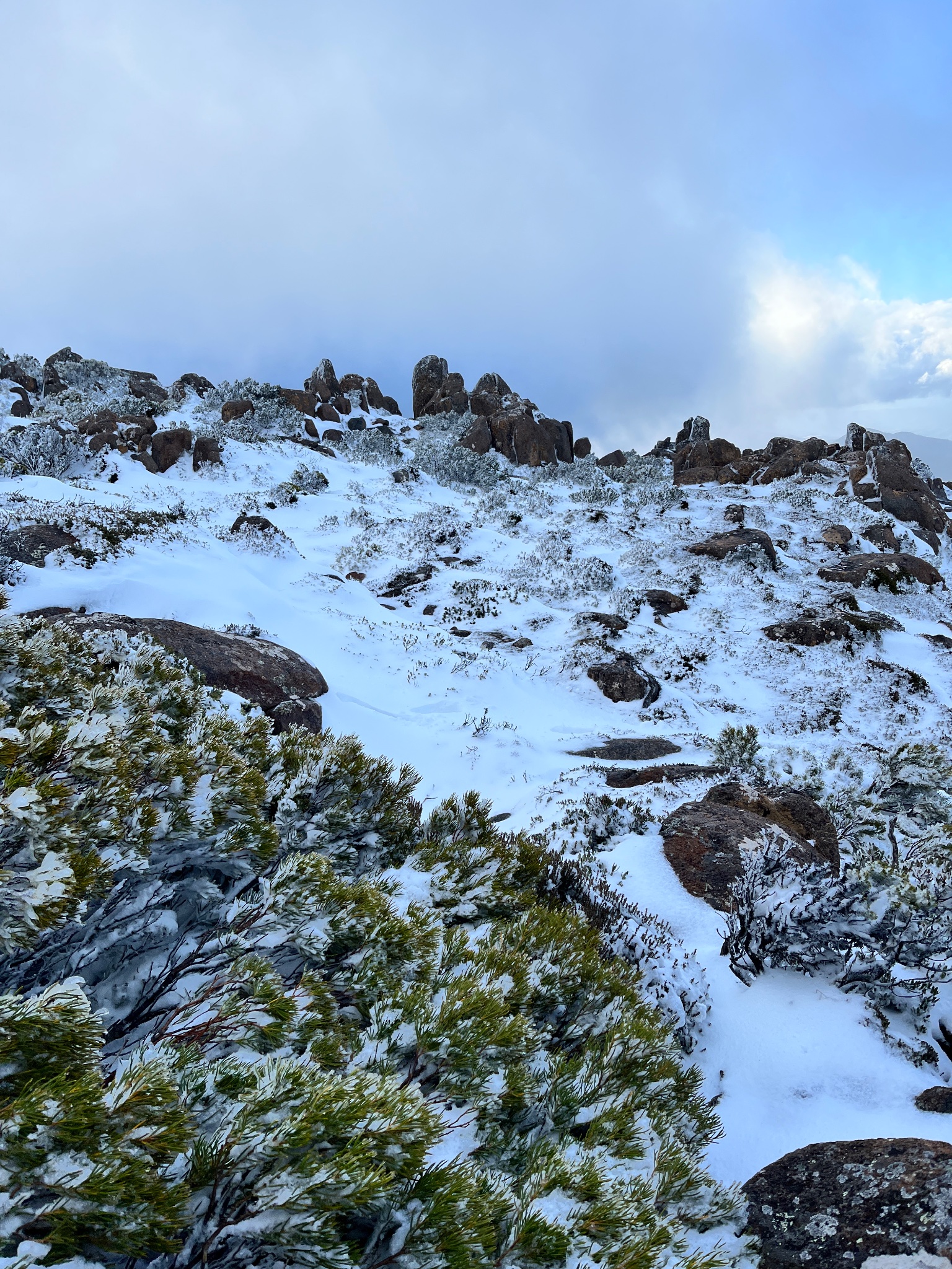
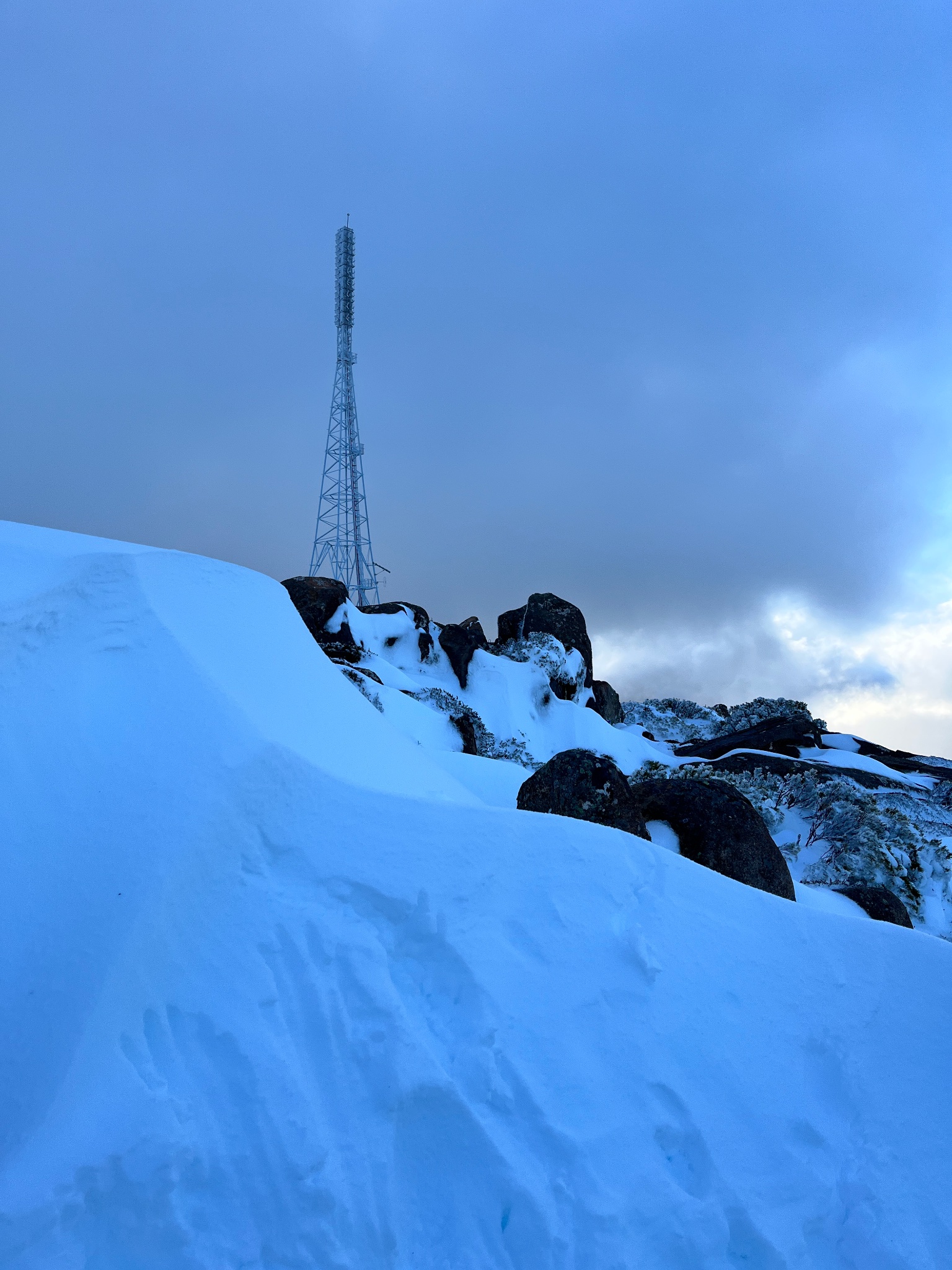
Went down to the Huon valley and was quite a lot of snow on the peaks. On the way back went past Kunanyi/Mt Wellington. Absolutely freezing up there with snow falling down to around 700m mid arvo. Some deep drifts on the Mt on the eastern and northern side due to the dry snow and high winds. Won’t last long, but nice to see some snow up there after a pretty lean start to the year and summer (only three light snowfalls for the year before this one).
- snowfall
- Supercell
- Reactions:
- Posts: 1290
- Joined: Mon Mar 20, 2017 7:39 pm
- Location: Gisborne South (349m asl)
Re: A deep low for Easter 2023
That’s some decent looking snow HB.
A max of just 11.6c and 2.4mm here today, which makes it our coldest day for the year so far. 59mm all up for the event. The last couple of weeks have delivered a very welcome autumn break for these parts. Currently drizzling and still fairly windy at times.
A max of just 11.6c and 2.4mm here today, which makes it our coldest day for the year so far. 59mm all up for the event. The last couple of weeks have delivered a very welcome autumn break for these parts. Currently drizzling and still fairly windy at times.
- jimmyay
- Cumulonimbus
- Reactions:
- Posts: 163
- Joined: Thu Dec 13, 2012 2:33 pm
- Location: Port Melbourne
Re: A deep low for Easter 2023
Another 15mm overnight. The city must have got under one of the streamers as it seems quite localised looking at the BOM totals.
Total for this event, since Thurs evening is 38.4 mm
77mm in the past 3 weeks.
Can’t remember an Easter weekend in the city being so consistently wet each day!
Total for this event, since Thurs evening is 38.4 mm
77mm in the past 3 weeks.
Can’t remember an Easter weekend in the city being so consistently wet each day!
Last edited by jimmyay on Mon Apr 10, 2023 9:12 am, edited 1 time in total.
-
Didjman
- Supercell
- Reactions:
- Posts: 2100
- Joined: Fri Sep 03, 2010 2:52 pm
- Location: Wallan, Vic 328m ASL
- Contact:
Re: A deep low for Easter 2023
In Wallan we have struggled to 8mm for the event!!
- Gordon
- Supercell
- Reactions:
- Posts: 2896
- Joined: Thu Jun 17, 2010 10:01 am
- Location: Near Gordon, Vic. 620 m asl
Re: A deep low for Easter 2023
38mm to 9am for Easter so far, and probably a couple more mm of drizzly showers to come. 46mm for April.
It is surprising how quickly we've turned from dust to mud, with little or no evaporation under high humidity and very cool temps.
Btw, for anyone already 'locking in' an El Nino year for 2023, this article makes interesting reading: https://www.abc.net.au/news/2023-04-10/ ... /102189516
It is surprising how quickly we've turned from dust to mud, with little or no evaporation under high humidity and very cool temps.
Btw, for anyone already 'locking in' an El Nino year for 2023, this article makes interesting reading: https://www.abc.net.au/news/2023-04-10/ ... /102189516
-
hillybilly
- Site Admin/Moderator
- Reactions:
- Posts: 5003
- Joined: Thu Nov 26, 2009 7:26 am
- Location: Howden Tasmania, 25m above sea level
- Contact:
Re: A deep low for Easter 2023
Southeasterly drizzle set up down here which usually means hours of drizzle but falling at a rate of 0.1mm/hr  1.4mm in the gauge for the best part of 24 hours of precipitation.
Better at elevation with a few nearby gauges showing around 5mm. Been cold with a max of 12C on Sunday and 13C here on Monday.
Little sneaky system mid week, ahead of another strong low for next weekend. Hopefully that’s good for follow-up rain.
For those watching the drivers the pacific is starting to look pretty ominous. SSTs near +3C on the South American coast and a big westerly wind burst about to hit the central pacific. Will be difficult to avoid an El Niño with that set up. No complaints here about the rain, given what spring could well look like.
-
Didjman
- Supercell
- Reactions:
- Posts: 2100
- Joined: Fri Sep 03, 2010 2:52 pm
- Location: Wallan, Vic 328m ASL
- Contact:
Re: A deep low for Easter 2023
Finished the event on 11mm here
- QldTwister
- Cumulonimbus
- Reactions:
- Posts: 434
- Joined: Tue May 22, 2012 7:56 pm
- Location: Ashwood Vic
Re: A deep low for Easter 2023
26mm here for Easter Weekend was a cold wet windy a depressing easter weekend glad i worked it
Some suburbs got under streams so had 50 to 60mm for the weekend really wet in places
Early taste of winter
Nice today more widespread rain showers tomorrow 5 to 15mm for most then mild late week before front ex Tc hit us hopefully that dumps for all farmers north of ranges so they can get planting
Some suburbs got under streams so had 50 to 60mm for the weekend really wet in places
Early taste of winter
Nice today more widespread rain showers tomorrow 5 to 15mm for most then mild late week before front ex Tc hit us hopefully that dumps for all farmers north of ranges so they can get planting
Bring on the heat and stroms
-
hillybilly
- Site Admin/Moderator
- Reactions:
- Posts: 5003
- Joined: Thu Nov 26, 2009 7:26 am
- Location: Howden Tasmania, 25m above sea level
- Contact:
Re: A deep low for Easter 2023
Bit of a sneaky system which fall over on our doorstep as the upper trough amplifies into QLD and a low bombs off north coast NSW. Looks like a productive system for western VIC, but will fade as you go east. Might be ok for TAS which sees strengthen northeast to east flow. Some storms mid arvo. Uppers are cool so wouldn’t be surprised to see a bit of small hail.
Weekends system looks impressive for major follow up. New thread soon
Weekends system looks impressive for major follow up. New thread soon
- Gordon
- Supercell
- Reactions:
- Posts: 2896
- Joined: Thu Jun 17, 2010 10:01 am
- Location: Near Gordon, Vic. 620 m asl
Re: A deep low for Easter 2023
Got one here hillybilly? viewtopic.php?t=2665hillybilly wrote: ↑Tue Apr 11, 2023 8:41 pm Weekends system looks impressive for major follow up. New thread soon