
Welcome New Members! We want to hear from you. Register, stop lurking and start posting!
Long hot spell: February 14-24
-
Didjman

- Supercell
- Reactions:
- Posts: 2099
- Joined: Fri Sep 03, 2010 2:52 pm
- Location: Wallan, Vic 328m ASL
- Contact:
Re: Long hot spell: February 14-24
Max temp 39.7 here and we are at 1000ft!! Back to 22 now
- stevco123
- Supercell
- Reactions:
- Posts: 2936
- Joined: Sat Aug 07, 2010 7:42 pm
- Location: Cranbourne 78m asl
Re: Long hot spell: February 14-24
First 40 degree February in 9 years in Melbourne. Hasn't been one since 2014
https://www.weatherlink.com/bulletin/53 ... 76dd68e8bc: for current weather updated every 2 minutes
-
hillybilly

- Site Admin/Moderator
- Reactions:
- Posts: 4986
- Joined: Thu Nov 26, 2009 7:26 am
- Location: Howden Tasmania, 25m above sea level
- Contact:
Re: Long hot spell: February 14-24
Back to cooler in the south for a few days, but short lived in the north. Mildura will be back in the mid 30s in a day or so.
Part b looks to be more focussed on western and northwestern areas with them high stubbornly parked well south and not budging. Further south is for for us as the fetch of northerlies tends to be shorter. Spike day around Friday which could be as hot or hotter than yesterday. Be horrible in places like Ceduna which are sat in the perfectly bad spot for the next round
Apparently temp yesterday was the first 40C after Valentine’s Day since 1998 in Melbourne. So many statistics Lot of them do really reflect the very unusual three year and quite consistently wet La Niña. La Niña tend to increase minima and reduce hot maxima and that’s what we’ve seen.
Not much rain. TAS will get storms today and a weak band of rain, and more showers Monday. Mainland looks very sparse.
Btw that black core storm went over a couple of amateur stations in south Gippsland. One station near Boolara scored 35mm and temperature drop of 20C. Must have been most exciting. Wonder if it had hail?
Part b looks to be more focussed on western and northwestern areas with them high stubbornly parked well south and not budging. Further south is for for us as the fetch of northerlies tends to be shorter. Spike day around Friday which could be as hot or hotter than yesterday. Be horrible in places like Ceduna which are sat in the perfectly bad spot for the next round
Apparently temp yesterday was the first 40C after Valentine’s Day since 1998 in Melbourne. So many statistics
Not much rain. TAS will get storms today and a weak band of rain, and more showers Monday. Mainland looks very sparse.
Btw that black core storm went over a couple of amateur stations in south Gippsland. One station near Boolara scored 35mm and temperature drop of 20C. Must have been most exciting. Wonder if it had hail?
- snowfall
- Supercell
- Reactions:
- Posts: 1286
- Joined: Mon Mar 20, 2017 7:39 pm
- Location: Gisborne South (349m asl)
Re: Long hot spell: February 14-24
38.8c here yesterday, along with a gusty fan-forced oven wind. This was also our hottest day in 3 years.
Currently 14c here now and cloudy. No doubt the cloud will clear but, thankfully, it should stay mild. Not looking forward to round 2 this week, as we're really needing some proper rain and having more heat and wind is not exactly helpful. It does feel like we're in the midst of a developing El Nino unfortunately. I just hope it's not also paired with a positive IOD, although a negative IOD almost seems out of the question!
Currently 14c here now and cloudy. No doubt the cloud will clear but, thankfully, it should stay mild. Not looking forward to round 2 this week, as we're really needing some proper rain and having more heat and wind is not exactly helpful. It does feel like we're in the midst of a developing El Nino unfortunately. I just hope it's not also paired with a positive IOD, although a negative IOD almost seems out of the question!
- Gordon
- Supercell
- Reactions:
- Posts: 2889
- Joined: Thu Jun 17, 2010 10:01 am
- Location: Near Gordon, Vic. 620 m asl
Re: Long hot spell: February 14-24
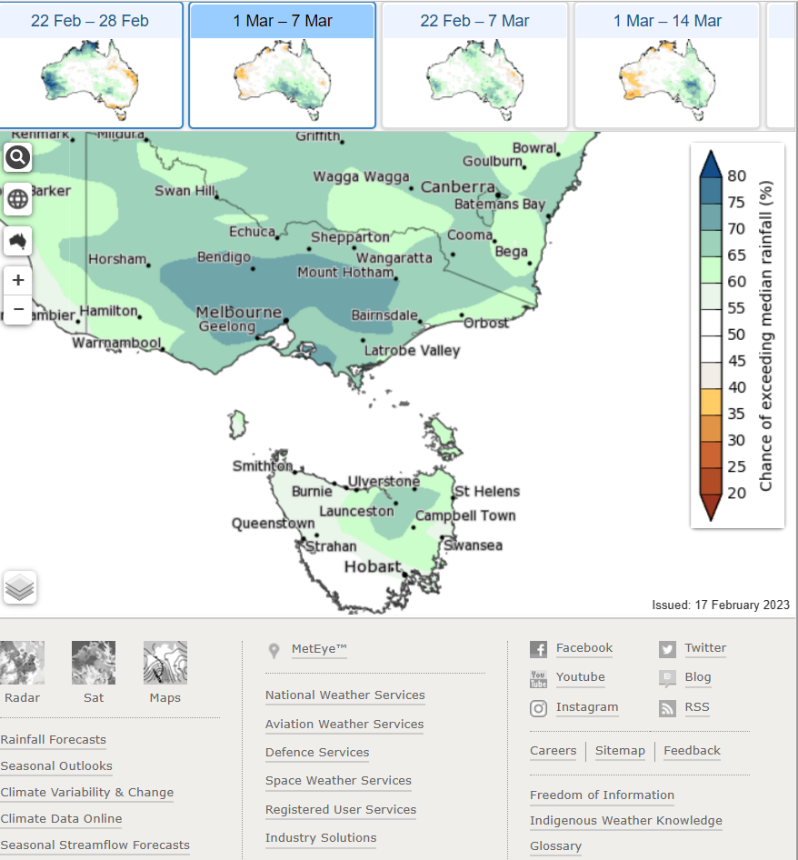
Outside the date range, but for those (like me!) looking for a bit of rain, BOM is sticking with above average falls for the first week of March:
- Tassiedave
- Supercell
- Reactions:
- Posts: 1098
- Joined: Thu Nov 11, 2010 11:09 am
- Location: Grindelwald Tasmania
Re: Long hot spell: February 14-24
Models split as to the length of the next heatwave. GFS has it sticking around into week after next. ACCESS flushes it away Saturday.
-
hillybilly
- Site Admin/Moderator
- Reactions:
- Posts: 4986
- Joined: Thu Nov 26, 2009 7:26 am
- Location: Howden Tasmania, 25m above sea level
- Contact:
Re: Long hot spell: February 14-24
Picked up 2mm here yesterday. Looked good on radar, but moved through quickly. Bit heavier around the Snug Tier which caught the best of it. Expecting a repeat tomorrow.
Couple of milder ones ahead then hot from around Wednesday. Looks like Thursday to Saturday will be hot for most. Based on EC Hobart could well see two 30C+ and Melbourne three 35C+ in a row. Mildura will be mid 30s to 40s for the best part of a week. Quite windy Thursday into Saturday so expect plenty of fire bans, particularly western areas.
Might end with a low and rain around this time next week (EC) or not (GFS).
-
Australis(Shell3155)

- Supercell
- Reactions:
- Posts: 3146
- Joined: Mon Nov 30, 2009 8:05 pm
- Location: FTG
- Contact:
Re: Long hot spell: February 14-24
[mention]Gordon[/mention]
We’ve got 80% 10/20mm sat 25th..
I’ll go half’s with ya..
I’m happy with just ten spread out of 6 hours in darkness.
If not I’ll have the remainder following eve.. plz..
Lots of crunchy gum leaves here, they just keep fluttering down..
Friday got hot mid afternoon, car said 39 FTG
had a storm pass through 6pm @Noojee, lightening started couple fires back of Glenmaggie..
-
hillybilly
- Site Admin/Moderator
- Reactions:
- Posts: 4986
- Joined: Thu Nov 26, 2009 7:26 am
- Location: Howden Tasmania, 25m above sea level
- Contact:
Re: Long hot spell: February 14-24
Pretty stark contrast across outheast Australia today with thick drizzle and fog to near sea level here in southern Tasmania (and 14C at noon) and mid 30s north of the divide in VIC. Heat spreads south from here. Hot and windy for Thursday, Friday and probably Saturday at this stage. Not good fire weather. Suspect the worst of the heat will go through SA with the slow movement of the high eventually pinching off the pool of hottest air.
Progs are very jumpy as to how this ends, with EC going for a substantial slow moving low with rain later on the weekend. Will wait see.
Progs are very jumpy as to how this ends, with EC going for a substantial slow moving low with rain later on the weekend. Will wait see.
- QldTwister
- Cumulonimbus
- Reactions:
- Posts: 434
- Joined: Tue May 22, 2012 7:56 pm
- Location: Ashwood Vic
Re: Long hot spell: February 14-24
Heat def down grading for the Melbourne area which sure many are happy with but was looking forward to the last burst of mid 30s sunny with afternoon cu about but few days low 30s better than 18c and drizzle
Cooler pattern into next week sad times trees strating to chnage color too NOOOO its only just become summer lol
Cooler pattern into next week sad times trees strating to chnage color too NOOOO its only just become summer lol
Bring on the heat and stroms
- Gordon
- Supercell
- Reactions:
- Posts: 2889
- Joined: Thu Jun 17, 2010 10:01 am
- Location: Near Gordon, Vic. 620 m asl
Re: Long hot spell: February 14-24
Left home in dawn fog and 7C for a week north of the border. And yes, heat does seem to be backing off (sorry Twister  )
)
For the coming weekend, I don't think I can recall such dogged disagreement between EC and GFS. It's now been days that EC has been on to rain for late Saturday/Sunday, while GFS just isn't interested - not for Vic anyway. Huh?
For the coming weekend, I don't think I can recall such dogged disagreement between EC and GFS. It's now been days that EC has been on to rain for late Saturday/Sunday, while GFS just isn't interested - not for Vic anyway. Huh?
- snowfall
- Supercell
- Reactions:
- Posts: 1286
- Joined: Mon Mar 20, 2017 7:39 pm
- Location: Gisborne South (349m asl)
Re: Long hot spell: February 14-24
To me, it's still looking pretty hot, with temps in the low to mid 30s for a few days, even if it's a bit less than originally forecast.
In its latest model run, GFS is now picking up some activity on the weekend, although projecting much less rainfall than EC. Who knows what will come out in the next model run! Definitely some uncertainty, so may have to wait a couple more days.
It has been drizzling here this morning, with the occasional heavier shower mixed in. 4mm so far.
-
hillybilly
- Site Admin/Moderator
- Reactions:
- Posts: 4986
- Joined: Thu Nov 26, 2009 7:26 am
- Location: Howden Tasmania, 25m above sea level
- Contact:
Re: Long hot spell: February 14-24
Cool one here today with the odd shower. Starts warming from here. Heat looks quite significant for TAS but lot depends on the timing. Models keep wiggling the change back and forth by two days
For Vic looks like topping out in the high 30s for most and low 40s northwest. Slower or the system stretches the hottest air so it covers a larger area but peak values are less.
For Vic looks like topping out in the high 30s for most and low 40s northwest. Slower or the system stretches the hottest air so it covers a larger area but peak values are less.
- stevco123
- Supercell
- Reactions:
- Posts: 2936
- Joined: Sat Aug 07, 2010 7:42 pm
- Location: Cranbourne 78m asl
Re: Long hot spell: February 14-24
Looks to be a quite windy few days too. Sort of good that the wind is coming from the north east as it will cap temperatures a little but will also be a little more humid
https://www.weatherlink.com/bulletin/53 ... 76dd68e8bc: for current weather updated every 2 minutes
-
hillybilly
- Site Admin/Moderator
- Reactions:
- Posts: 4986
- Joined: Thu Nov 26, 2009 7:26 am
- Location: Howden Tasmania, 25m above sea level
- Contact:
Re: Long hot spell: February 14-24
46.8C today in Eucla. Apparently the equal hottest February day anywhere in Australia in the last four years. Guess three of those have been La Nina. Does show how nasty the air mass is. Thankfully doesn’t quite make into to the southeast.
- QldTwister
- Cumulonimbus
- Reactions:
- Posts: 434
- Joined: Tue May 22, 2012 7:56 pm
- Location: Ashwood Vic
Re: Long hot spell: February 14-24
Nice day today then gusty SE winds espically down south and by the bay.
Next 2 days look real nice trying to get out there get the last few beach days of the season in, long cool strech next week booo lol.
Hoping with fresh Nlys next few days can at least move into the mid 30s next 2 days and change on weekend all over the place.
Next 2 days look real nice trying to get out there get the last few beach days of the season in, long cool strech next week booo lol.
Hoping with fresh Nlys next few days can at least move into the mid 30s next 2 days and change on weekend all over the place.
Bring on the heat and stroms
- snowfall
- Supercell
- Reactions:
- Posts: 1286
- Joined: Mon Mar 20, 2017 7:39 pm
- Location: Gisborne South (349m asl)
Re: Long hot spell: February 14-24
28c here so far today - perhaps a little cooler than originally forecast.
The wind has died down but it has been very blustery, especially this morning. Not too sure about the stats, but it has felt like a windy summer this year, repeatedly shifting from dry vigorous southerlies to hot, dry northerlies and not much else in between. Looking forward to a cooler change later in the weekend, but unfortunately it doesn't look like there will be much rain. EC and GFS are still quite divergent, but there's also a fair bit of variation across all models heading into next week.
The wind has died down but it has been very blustery, especially this morning. Not too sure about the stats, but it has felt like a windy summer this year, repeatedly shifting from dry vigorous southerlies to hot, dry northerlies and not much else in between. Looking forward to a cooler change later in the weekend, but unfortunately it doesn't look like there will be much rain. EC and GFS are still quite divergent, but there's also a fair bit of variation across all models heading into next week.
- QldTwister
- Cumulonimbus
- Reactions:
- Posts: 434
- Joined: Tue May 22, 2012 7:56 pm
- Location: Ashwood Vic
Re: Long hot spell: February 14-24
Ripper day down beach yesterday but few degrees warmer would have been nice still was really nice and the water awesome.
Today its great but bit of wind hot night as well on the way might be last real hot day so been out enjoying it and heading to beach soon for hours cant wait
Cool Slys bit dull next week hopefully still mostly sunny not cloiudly for days
Today its great but bit of wind hot night as well on the way might be last real hot day so been out enjoying it and heading to beach soon for hours cant wait
Cool Slys bit dull next week hopefully still mostly sunny not cloiudly for days
Bring on the heat and stroms
-
hillybilly
- Site Admin/Moderator
- Reactions:
- Posts: 4986
- Joined: Thu Nov 26, 2009 7:26 am
- Location: Howden Tasmania, 25m above sea level
- Contact:
Re: Long hot spell: February 14-24
Been a hot couple of days in southern Tasmania as the heat dips under VIC. 30C yesterday and 32C today. That’s about the equivalent of 37C in Melbourne.
Is interesting how the slowing of this event stretched the heat South and under VIC. Basically a non event. Back in SA some significant extremes including Adelaide Ap which missed breaking its February high minimum by 0.2C.
Warm tomorrow then a rainy night. Could be heavy. EC and other models have been putting bigs storms and a heavy wrap around rain event into southeast Tasmania. Locally over 100mm. Guess we will see. Is seriously dry, so a big dump would be welcome. VIC will get a bit, then a much cooler and potentially showery week ahead. New thread perhaps.
- Gordon
- Supercell
- Reactions:
- Posts: 2889
- Joined: Thu Jun 17, 2010 10:01 am
- Location: Near Gordon, Vic. 620 m asl
Re: Long hot spell: February 14-24
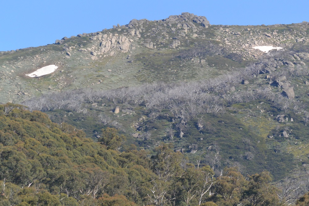
Definitely new thread time, but what weird week just gone! Up in the Snowys, the heat missed almost completely - and not just because of elevation. Seemed to pick up onshore southeasterlies which kept it mild, even downright cold on Wednesday. Amazing to see snow drifts still lingering on the Main Range - these spots have been under snow since May, so getting on towards 10 months if some make it to March, which is something I can't recall for the last two decades at least.
Much warmer back home apparently, but cooler here now.
(PS: Rainband looking better than expected on the radar - assuming it can hold together.)
Much warmer back home apparently, but cooler here now.
(PS: Rainband looking better than expected on the radar - assuming it can hold together.)