Page 3 of 4
Re: Series of front with possible cold outbreak: April 8-12
Posted: Sun Apr 11, 2021 2:24 pm
by Adam38
Only a few mm here and plenty of wind... nothing unusual for Bacchus Marsh, I’ve got the wood fire on for the first time this year.
Closely watching that cyclone out west ( family lives there ) and it has now strengthened to a cat 3 with an eye developing... Latest forecast has in tracking very close to Geraldton ( pop 38,000 ), houses aren’t built to withstand cyclones that far south.
Re: Series of front with possible cold outbreak: April 8-12
Posted: Sun Apr 11, 2021 4:49 pm
by Onetahuti
The main part of the event seems to have largely passed with the possibility of just a few showers remaining. Here I have recorded 58mm since yesterday morning so 68mm for the whole event time frame. Happy to leave it there!
Adam38 wrote: ↑Sun Apr 11, 2021 2:24 pm
Closely watching that cyclone out west ( family lives there ) and it has now strengthened to a cat 3 with an eye developing... Latest forecast has in tracking very close to Geraldton ( pop 38,000 ), houses aren’t built to withstand cyclones that far south.
TC Seroja is 'flying', forecast to be moving at around 50 km per hour when it crosses the coast, thankfully it is still projected to pass north of Geraldton which will lessen impact of the winds had it been passing to the town's south. Niece and family moved there in 2019, bought there last year.
Re: Series of front with possible cold outbreak: April 8-12
Posted: Sun Apr 11, 2021 6:36 pm
by hillybilly
Wild winters day up here. Max of 7.2C and now on 76mm for the weekend and 95mm MTD. Coldest April day up here since 1995. Remarkable that there was a max of 5.4C here on April 7 1995. Don’t recall that day, but must have been feral. I was living on the flats in Fitzroy that year.
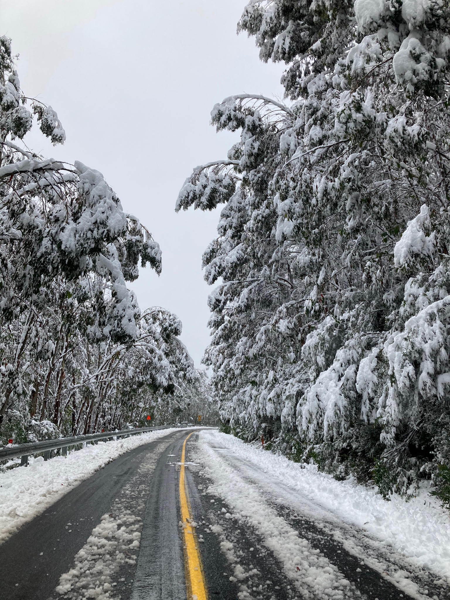
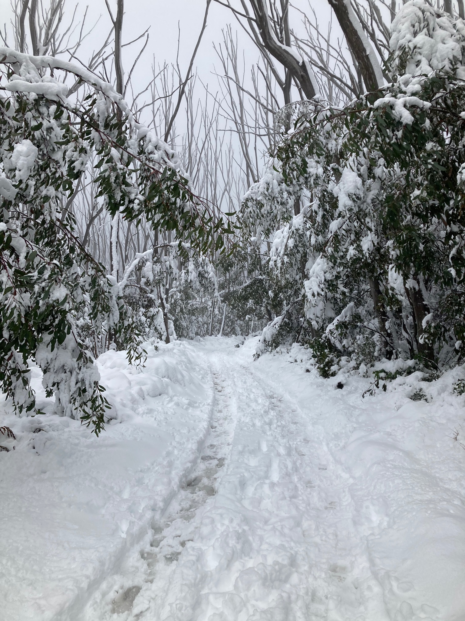
Made it to Lake Mt. Was settled snow in Marysville (something that is just extraordinary for April) and then heavy snow up top. 30-40cm on the summit. There was drift over 60cm, no toll gate fees and not many people

Here’s a few photos. Best snow day I’ve seen up there in a few years.
Btw lots of damage and over wash from the waves on the coast. So lucky the tides were fairly low. Water came up onto the Great Ocean Road at Apollo Bay. Roads overwashed around Ocean Grove and Port Fairy.

Re: Series of front with possible cold outbreak: April 8-12
Posted: Sun Apr 11, 2021 6:45 pm
by hillybilly
Storm damage around Port Fairy.


Re: Series of front with possible cold outbreak: April 8-12
Posted: Sun Apr 11, 2021 6:52 pm
by hillybilly
And... record TC impact in WA tonight. Cat 3 headed for Geraldton which lies outside of the TC building standards. Seems this is a first in the modern records. The jetty at Carnarvon has already been lost. Expected to weaken to Cat 2 prior to landfall.
These events are all related. The record TC Sejora with TC Odette (leading to the fujiwhara effect) has led to Rossby wave amplification (big upper ridge and downstream big upper trough) which gave us this polar blast and huge wave event. All round a freak event.
Re: Series of front with possible cold outbreak: April 8-12
Posted: Sun Apr 11, 2021 8:00 pm
by Adam38
Re: Series of front with possible cold outbreak: April 8-12
Posted: Sun Apr 11, 2021 8:20 pm
by Gordon
hillybilly wrote: ↑Sun Apr 11, 2021 6:36 pm
Wild winters day up here. Max of 7.2C and now on 76mm for the weekend and 95mm MTD. Coldest April day up here since 1995. Remarkable that there was a max of 5.4C here on April 7 1995. Don’t recall that day, but must have been feral. I was living on the flats in Fitzroy that year.
Made it to Lake Mt. Was settled snow in Marysville (something that is just extraordinary for April) and then heavy snow up top. 30-40cm on the summit. There was drift over 60cm, no toll gate fees and not many people
Here’s a few photos. Best snow day I’ve seen up there in a few years.
Great pics thanks hillybilly. What a snow event for early April

!
Re: Series of front with possible cold outbreak: April 8-12
Posted: Sun Apr 11, 2021 8:46 pm
by snowfall
Great pics - looks like mid-winter! Just 0.4mm here today, as everything swept to the east of us. The sun even popped out a few times. So a more modest, but welcome, 13.2mm for the weekend.
That TC will be on Geraldton’s doorstep very soon at the rate it’s moving.
Re: Series of front with possible cold outbreak: April 8-12
Posted: Mon Apr 12, 2021 7:51 am
by hillybilly
1mm overnight and fog an drizzle this morning. City playing catch-up with 9mm and doing ok for the month.
Looks like a chilly damp day in the south. Is clearing but slowly, but won’t be all gone till late.
Historic TC strike in WA. That system will pass to our south but we get gusty winds and warm air, followed by a swly change with showers.
Re: Series of front with possible cold outbreak: April 8-12
Posted: Mon Apr 12, 2021 7:55 am
by StratoBendigo
Clear skies and a 4c minimum this morning. Brisk.
Reports of significant damage in WA. Strong winds went a long way inland too. On the bright side the WA wheatbelt has got some good rains to kick off the winter growing season.
Re: Series of front with possible cold outbreak: April 8-12
Posted: Mon Apr 12, 2021 9:30 am
by snowfall
2.4mm overnight here. Only down to 7.4c this morning, so a fair a bit milder than yesterday.
The TC, now a low, will be out in the southern ocean by early afternoon. It’s rapid movement has also meant we haven’t seen the usual big rainfall totals for a TC. Geraldton was close to a direct hit, with gusts up to 120km/h last night but only 33mm of rain. Similar through the inland track, but probably better for farmers than being inundated.
Re: Series of front with possible cold outbreak: April 8-12
Posted: Tue Apr 13, 2021 8:53 am
by hillybilly
Picked up another mm from those clearing showers yesterday with a chilly max of 11.2C. 76mm for the event and MTD just on 95mm. As hoping to crack 100mm for the week, just because

but don’t like my odds unless we get a stray shower overnight.
Back to more normal April temps tonight, and actually quite warm tonight with the warm uppers from the ex cyclone and strong winds coming through. Winds look nasty in elevated spots, with EC showing gusts over 100km/hr for a good 12-18 hours, particularly near the peaks.
Not much rain in it, and most is behind the trough when we get decently cool uppers and a swly flow. It’s actually going to cool down enough late in the week for a bit more snow in the alps. Not quite sure it’s worth another thread.
Re: Series of front with possible cold outbreak: April 8-12
Posted: Tue Apr 13, 2021 8:57 am
by Australis(Shell3155)
12 - 18 hrs wind
Wet ground, trees will fall.
What time is this wind starting ?
Need to set up camp in the lounge..
good thing its where the fire is..
Re: Series of front with possible cold outbreak: April 8-12
Posted: Tue Apr 13, 2021 9:16 am
by Skywalker
The filth returns today which will make the ride home later rather annoying.

Really struggling to adapt to the change of conditions, especially after several weeks of calm conditions. Sunday was horrible for my son's first game of junior footy for the year. Poor kids couldn't even kick the ball into the disgusting windy filth.
The longest, boring & most depressing time of the year has arrived.

Re: Series of front with possible cold outbreak: April 8-12
Posted: Tue Apr 13, 2021 12:01 pm
by Wilko
Finally we are settling in a Autumn pattern ahead
NW winds and good surfing

Registered 18mm from the previous event
Re: Series of front with possible cold outbreak: April 8-12
Posted: Tue Apr 13, 2021 2:39 pm
by StratoBendigo
NW winds are roaring through South Australia today. Total Fire Bans in place for some districts.
Just cool and overcast here with a gusty NWly, after a very cold 3c start to the day.
Re: Series of front with possible cold outbreak: April 8-12
Posted: Tue Apr 13, 2021 7:42 pm
by hillybilly
Up to 13C here today. Felt quite mild after the wintery blast.
Had a couple of spits, but dry low levels killing our rain chances with this system. Maybe a shower or two, and a bit better on Thursday in the colder air.
Winds blow now for a good 12 hours. Hasn’t been too bad up here, though we tend to get our worst winds here at night so will see.
Re: Series of front with possible cold outbreak: April 8-12
Posted: Wed Apr 14, 2021 7:39 am
by hillybilly
Woken by a couple of heavy showers in the night, though short lived. 1.4mm in the gauge.
Might get a couple more early arvo.
Wind has been pretty uneventful, which is a good thing

Re: Series of front with possible cold outbreak: April 8-12
Posted: Wed Apr 14, 2021 7:08 pm
by hillybilly
Down on the coast this evening. Been mild and blustery. A couple of nice coldies, but small and big gaps between them. Just on a mm here. Still big swells on the coast, and really high water levels. Water was not far below the road at Tarwin this arvo, so quite a storm surge with these westerlies.
Tomorrow will see a nice morning, followed by a showery arvo. Marks the end of this sequence.
Potential system brewing for next week.
Re: Series of front with possible cold outbreak: April 8-12
Posted: Thu Apr 15, 2021 6:19 pm
by hillybilly
Bit of a fizzer in the Nongs with just 1mm so far, but feral down here in Walkerville with a series of strong coldies. Poured a couple of times with small hail. 12mm today and 4mm last night. Has been quite dry down here by south Gippsland standards so very welcome.
Took a look at a few beaches today. They really suffered from that swell. Put up some photos later.
 Here’s a few photos. Best snow day I’ve seen up there in a few years.