Temperatures look like peaking in the high 30 to low 40s north, and mid to high 30s in the south. Good beach weather - and I’m headed to the beach

Welcome New Members! We want to hear from you. Register, stop lurking and start posting!
January 9-16: Warm to hot, with the odd shower
-
hillybilly

- Site Admin/Moderator
- Reactions:
- Posts: 5009
- Joined: Thu Nov 26, 2009 7:26 am
- Location: Howden Tasmania, 25m above sea level
- Contact:
January 9-16: Warm to hot, with the odd shower
Pretty dull period of weather coming up, though it will bring our first hot conditions for a while. There’s a chance of the odd shower and storm Tuesday to Thursday with weak troughs. Fairly cool air pushes in late, with possible showers in the south.
Temperatures look like peaking in the high 30 to low 40s north, and mid to high 30s in the south. Good beach weather - and I’m headed to the beach
Temperatures look like peaking in the high 30 to low 40s north, and mid to high 30s in the south. Good beach weather - and I’m headed to the beach
- snowfall
- Supercell
- Reactions:
- Posts: 1292
- Joined: Mon Mar 20, 2017 7:39 pm
- Location: Gisborne South (349m asl)
Re: January 9-16: Warm to hot, with the odd shower
A sunny 27.6c currently here. Our warmest day since 27th December.
Rainfall is looking very limited over the next couple of weeks according to current model projections, with a few bursts of heat, but Week 2 is out on fantasy island so you never know, it might change. That said, it looks like tropical moisture might be a little hard to find, especially with the MJO remaining weak, so fronts that do come along are likely to struggle to produce any decent rainfall. It is midsummer after all, and long stretches of dry weather are typical. On the plus side, the garden here seems to be relishing the sunshine after a long period of cloud cover.
Rainfall is looking very limited over the next couple of weeks according to current model projections, with a few bursts of heat, but Week 2 is out on fantasy island so you never know, it might change. That said, it looks like tropical moisture might be a little hard to find, especially with the MJO remaining weak, so fronts that do come along are likely to struggle to produce any decent rainfall. It is midsummer after all, and long stretches of dry weather are typical. On the plus side, the garden here seems to be relishing the sunshine after a long period of cloud cover.
-
hillybilly
- Site Admin/Moderator
- Reactions:
- Posts: 5009
- Joined: Thu Nov 26, 2009 7:26 am
- Location: Howden Tasmania, 25m above sea level
- Contact:
Re: January 9-16: Warm to hot, with the odd shower
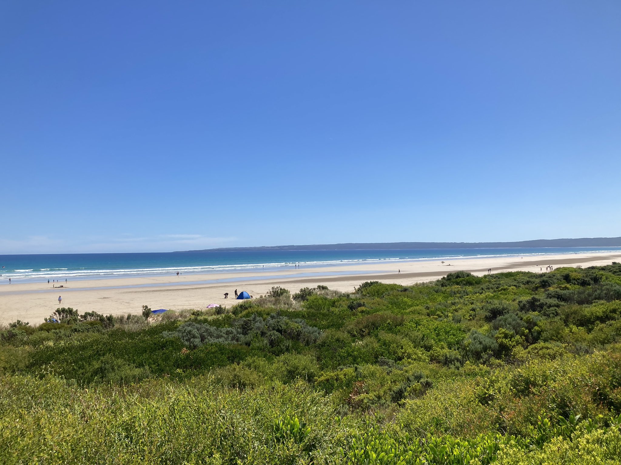
Beaut day at the beach yesterday. Almost calm, warm and humid and sunny. This was Sandy Point looking towards Walkerville. Doesn’t get better
Reached 27C back home in FC.
Today looks similar, perhaps a degree or two hotter. We had overnight fog here in south Gippsland.
Reached 27C back home in FC.
Today looks similar, perhaps a degree or two hotter. We had overnight fog here in south Gippsland.
-
Didjman

- Supercell
- Reactions:
- Posts: 2100
- Joined: Fri Sep 03, 2010 2:52 pm
- Location: Wallan, Vic 328m ASL
- Contact:
Re: January 9-16: Warm to hot, with the odd shower
Was a fine dawn here with cirrus above. Then the fog rolled in! 15/14.1 atm.
-
chasersaddict76

- Cumulus
- Reactions:
- Posts: 83
- Joined: Wed Jul 10, 2019 8:36 pm
- Location: Bendigo
Re: January 9-16: Warm to hot, with the odd shower
While we have boring Hot weather until next 9 Days is Cold cut off Upper low is trapped snd moving to SE Australia bring wet..Too Early Chart might change.
- Attachments
-
- weather.jpg (458 KiB) Viewed 9059 times
-
hillybilly
- Site Admin/Moderator
- Reactions:
- Posts: 5009
- Joined: Thu Nov 26, 2009 7:26 am
- Location: Howden Tasmania, 25m above sea level
- Contact:
Re: January 9-16: Warm to hot, with the odd shower
29C for a max in FC, and about 26C at Walkerville. Beautiful summer day, but move inland and lower and it was getting a bit uncomfortable.
Another hot one today ahead of a very late change. EC has it through Melbourne in the evening and it moving very slowly. Might be the odd shower behind the change, though suspect most spots will miss out. Fire warnings up for northern parts.
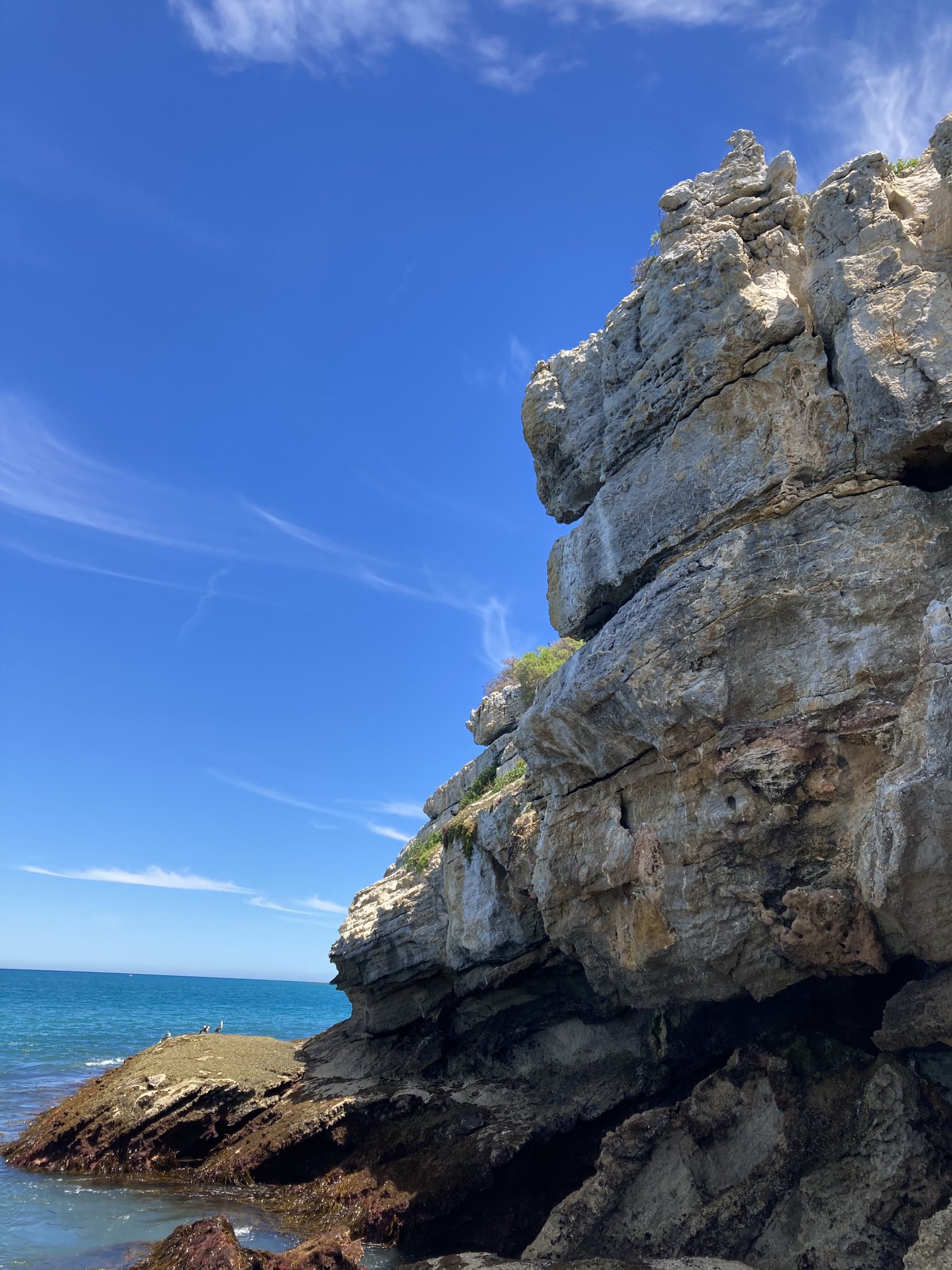
Here’s a photo from out on Waratah Bay. Was stunning blue skies with wisps of cirrus. Today is a bit more unstable with a little altocumulus.
Another hot one today ahead of a very late change. EC has it through Melbourne in the evening and it moving very slowly. Might be the odd shower behind the change, though suspect most spots will miss out. Fire warnings up for northern parts.
Here’s a photo from out on Waratah Bay. Was stunning blue skies with wisps of cirrus. Today is a bit more unstable with a little altocumulus.
- StratoBendigo
- Supercell
- Reactions:
- Posts: 2818
- Joined: Fri Jan 02, 2015 2:18 pm
- Location: Kangaroo Flat
Re: January 9-16: Warm to hot, with the odd shower
Very windy here - gusting to 60 km/h. Already a few small grassfires have broken out.
- snowfall
- Supercell
- Reactions:
- Posts: 1292
- Joined: Mon Mar 20, 2017 7:39 pm
- Location: Gisborne South (349m asl)
Re: January 9-16: Warm to hot, with the odd shower
Max of 33.3c here today. Looking forward to the cool change tonight, even if the respite is brief. Still nothing really coming up for rain in the foreseeable future.
-
hillybilly
- Site Admin/Moderator
- Reactions:
- Posts: 5009
- Joined: Thu Nov 26, 2009 7:26 am
- Location: Howden Tasmania, 25m above sea level
- Contact:
Re: January 9-16: Warm to hot, with the odd shower
36C in Walkerville today, and 30C in FC. Certainly on the warm side. Was warm in the water - though out deep still needed a winter wet suit (while in the shallows board shorts were fine).
Change has just hit here in the coast. Big gust and cooler, but more humid. Might see a shower overnight or in the morning. Very little in it, and thinking probably drizzle is the more likely precip (plus a few muddy drops tonight from the elevated convection).
No relief in the north with heat for two more days.
-
Australis(Shell3155)

- Supercell
- Reactions:
- Posts: 3147
- Joined: Mon Nov 30, 2009 8:05 pm
- Location: FTG
- Contact:
Re: January 9-16: Warm to hot, with the odd shower
Lucky enough to get those few odd showers,
-
hillybilly
- Site Admin/Moderator
- Reactions:
- Posts: 5009
- Joined: Thu Nov 26, 2009 7:26 am
- Location: Howden Tasmania, 25m above sea level
- Contact:
Re: January 9-16: Warm to hot, with the odd shower
Change proper pushed through the Nongs at 3am. Temperature dropped from 23 to about 15c in minutes. Followed by fog and light drizzle with 0.4mm in the gauge. At Walkerville, similar though cloud just about the ground and a trace only.
One more warm one tomorrow in the south, hot in the north then a fairly long mild spell. Maybe a shower or two in the south, mainly. The fronts approaching later in the week and early next week are quite strong, but we only get the tips with the weather mainly to our south and east.
One more warm one tomorrow in the south, hot in the north then a fairly long mild spell. Maybe a shower or two in the south, mainly. The fronts approaching later in the week and early next week are quite strong, but we only get the tips with the weather mainly to our south and east.
- StratoBendigo
- Supercell
- Reactions:
- Posts: 2818
- Joined: Fri Jan 02, 2015 2:18 pm
- Location: Kangaroo Flat
Re: January 9-16: Warm to hot, with the odd shower
Absolutely no rain in any of the forecasts for the rest of January. This summer will likely be drier than last year, and we're meant to be in a moderate La Nina? Pathetic.
- Tassiedave
- Supercell
- Reactions:
- Posts: 1101
- Joined: Thu Nov 11, 2010 11:09 am
- Location: Grindelwald Tasmania
Re: January 9-16: Warm to hot, with the odd shower
Tas rainfall overnight: Mount Read 27mm, Zeehan 17mm, Meander 7.2mm, Hobart 6.6mm, Launceston 4.2mm
-
hillybilly
- Site Admin/Moderator
- Reactions:
- Posts: 5009
- Joined: Thu Nov 26, 2009 7:26 am
- Location: Howden Tasmania, 25m above sea level
- Contact:
Re: January 9-16: Warm to hot, with the odd shower
MJO is unfavourable atm. Would look for increasing activity in. 1-2 weeks. January has seen a fading monsoon in line with the MJO after a bumper December of rainfall for most of OZ.StratoBendigo wrote: ↑Tue Jan 12, 2021 8:55 am Absolutely no rain in any of the forecasts for the rest of January. This summer will likely be drier than last year, and we're meant to be in a moderate La Nina? Pathetic.
In the Nongs and Walkerville we’ve already reach our combined December/January rainfall average with 70mm and 75mm respectively so far for January. North central has been very unlucky
- snowfall
- Supercell
- Reactions:
- Posts: 1292
- Joined: Mon Mar 20, 2017 7:39 pm
- Location: Gisborne South (349m asl)
Re: January 9-16: Warm to hot, with the odd shower
Some drizzle here earlier this morning. Enough to wet the ground but not enough to actually register in the gauge. It was a very warm evening, staying around 26-28 degrees with the change not fully coming through until just after midnight. Just a max of 20c today though, so much more comfortable. It's certainly looking dry for quite a while. Even northern Australia is not particularly active at the moment. As HB mentioned, the MJO is not working in our favour currently and high pressure systems have edged further north as the positive SAM weakens.
We still have reasonable soil moisture here due to the big falls earlier in the month, but it is drying quickly. It doesn't take much at this time of the year - a few hot days and some windy weather can really bump up the evaporation rate.
We still have reasonable soil moisture here due to the big falls earlier in the month, but it is drying quickly. It doesn't take much at this time of the year - a few hot days and some windy weather can really bump up the evaporation rate.
- Tassiedave
- Supercell
- Reactions:
- Posts: 1101
- Joined: Thu Nov 11, 2010 11:09 am
- Location: Grindelwald Tasmania
Re: January 9-16: Warm to hot, with the odd shower
Tas temps today: Launceston 28.1 (5.35pm), Scottsdale 27.3, St Helens 27.1 (midday), Devonport 25.5, Hobart 20.9 (7.45am)
-
hillybilly
- Site Admin/Moderator
- Reactions:
- Posts: 5009
- Joined: Thu Nov 26, 2009 7:26 am
- Location: Howden Tasmania, 25m above sea level
- Contact:
Re: January 9-16: Warm to hot, with the odd shower
Mild sunny arvo in FC and Walkerville with a max of 19C in both. Nice on the beach.
Hot one tomorrow.
We might actually get a decent front for Friday. Most models are now showing quite a strong system with showers and storms ahead of it, and 850Ts dipping to near 0C. We are a bit on the edge so it could get a lot better with a bit of a tweak one way, or largely fade with a tweak the other way. Be nice to sneak something

- Skywalker
- Supercell
- Reactions:
- Posts: 1872
- Joined: Sun Nov 29, 2009 10:03 am
- Location: Burnside Heights/Cowes (Home) & Sunshine West (Work)
Re: January 9-16: Warm to hot, with the odd shower
It's a real yawn fest out there today with absolutely nothing happening. Boring boring BORING! 
Unfortunately it's likely to be like this until at least the end of the month.
Unfortunately it's likely to be like this until at least the end of the month.
Caroline Springs, Melbourne's meteorological boredom zone.
-
hillybilly
- Site Admin/Moderator
- Reactions:
- Posts: 5009
- Joined: Thu Nov 26, 2009 7:26 am
- Location: Howden Tasmania, 25m above sea level
- Contact:
Re: January 9-16: Warm to hot, with the odd shower
Hot one in FC today with 30C. Big diurnal temperature range from just 9.5C.
Few showers this arvo but nothing too significant.
Should get a shower or two tomorrow which might scape a mm or two if you are lucky.
Front for Friday is looking quite strong. Could well pack some thunderies and then snow on the alpine peaks. Latest EC has nearly 20mm here, with other models looking solid. Won’t be so great inland as the link to the tropics is weak.
- StratoBendigo
- Supercell
- Reactions:
- Posts: 2818
- Joined: Fri Jan 02, 2015 2:18 pm
- Location: Kangaroo Flat
Re: January 9-16: Warm to hot, with the odd shower
La-Nina? Nope, just bad duststorms North of Broken Hill today: