Page 1 of 8
VIC - Sequence of fronts (Part 2): August 14-22 2018
Posted: Mon Aug 13, 2018 7:21 am
by hillybilly
Another week and a bit of frequent fronts, possibly leading to a significant cold outbreak for the weekend ahead. Should be showers on each day in the south and near the ranges. Temperatures start out fairly mild, then cool to about average, before dropping further towards the end of the sequence. Could be some low level snow developing, but progs not that consistent on how cold 850Ts will get (somewhere in the -3 to -5C range).
Rain totals will be quite significant about the coast and the ranges, locally above 50mm. Will be more sparse as you head into the rainshadows and the northwest.
Re: A sequence of fronts (part 2): August 14-22
Posted: Mon Aug 13, 2018 8:26 am
by flyfisher
Looking at the Satellite image, tropical moisture is feeding into the westerlies to the west of Australia. This could help increase rain in the westerly fronts going forward. Still no signs of a good NW cloud band. I think the only thing that can give drought-breaking rains now is an inland cut off tapping Pacific moisture - no sign of that.
Re: A sequence of fronts (part 2): August 14-22
Posted: Mon Aug 13, 2018 7:31 pm
by hillybilly
Not wanting to jinx the systems but EC and GFS are cranking a big cold outbreak for the weekend. 850Ts down to -5C with lots of showers.
Hopefully this one doesn't disappear in the coming days

Re: A sequence of fronts (part 2): August 14-22
Posted: Mon Aug 13, 2018 10:54 pm
by 93ben
hillybilly wrote: ↑Mon Aug 13, 2018 7:31 pm
Not wanting to jinx the systems but EC and GFS are cranking a big cold outbreak for the weekend. 850Ts down to -5C with lots of showers.
Hopefully this one doesn't disappear in the coming days
And snow apparently down to 500m on Sunday to affect Mt Dandenong between 4am to 10am
Re: A sequence of fronts (part 2): August 14-22
Posted: Tue Aug 14, 2018 6:31 am
by Tassiedave
Rainfall since 9 Mon: Mt Bobs 87mm, Mt Read 64mm, Strathgordon 50mm, Cradle Mt 34mm, Butlers Gorge 31mm, Strahan 6mm
Re: A sequence of fronts (part 2): August 14-22
Posted: Tue Aug 14, 2018 6:43 am
by hillybilly
snow apparently down to 500m on Sunday to affect Mt Dandenong between 4am to 10am
GFS and EC both have the freeIng level with showers dropping below 800m. Looks like it might dip into the 600 to 700m range which is similar to the August 2008 event when it last snowed properly here. It’s getting harder and harder to get good snowfalls here (because prefrontal is when you have the moisture but nowadays it’s rarely cold enough) so still a bit sceptical that something will go wrong
Meanwhile a cool to mild and windy one today ahead of a fast moving front tomorrow. EC and GFs have 5-10mm for much of southern Vic tomorrow so a hand inbetween type of system.
Amazing rainfall down in Tas Dave. These westerlies really crank for those areas.
Re: A sequence of fronts (part 2): August 14-22
Posted: Tue Aug 14, 2018 7:35 am
by Tassiedave
it was 14.5 degrees in Hobart at 6am. Weather forecaster on this morning's ABC country program at 635 suggested that snow could be down to 150 - 200 metres in the south of Tasmania on Sunday morning
Re: A sequence of fronts (part 2): August 14-22
Posted: Tue Aug 14, 2018 9:29 am
by JasmineStorm
GFS 18Z is taking -30c @ 500 hPA to the Queensland border on Sunday night. There also seems to be a major cold breach around the tropopause over SE OZ kicked off by a sudden stratospheric warming event. Models are going rogue on this set up.....waiting for the downgrade but the projected ice age is now only 140 hours out

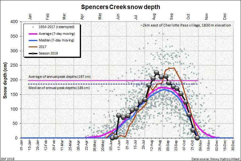
on a side topic, looks like Spencer creek is going to smash the 2m snow depth for a 2nd year running. A mini trend developing.
Re: A sequence of fronts (part 2): August 14-22
Posted: Tue Aug 14, 2018 9:48 am
by Adam38
I really hope I can get some decent rain from this event, only received about 6mm and a lot
of drying wind from the last event.
On another note Perth (my home town) passed its August average rainfall with another 20mm overnight
taking the MTD to 130mm and YTD to 608mm on 67 days.
Re: A sequence of fronts (part 2): August 14-22
Posted: Tue Aug 14, 2018 11:25 am
by Gordon
JasmineStorm wrote: ↑Tue Aug 14, 2018 9:29 am
GFS 18Z is taking -30c @ 500 hPA to the Queensland border on Sunday night. There also seems to be a major cold breach around the tropopause over SE OZ kicked off by a sudden stratospheric warming event. Models are going rogue on this set up.....waiting for the downgrade but the projected ice age is now only 140 hours out
on a side topic, looks like Spencer creek is going to smash the 2m snow depth for a 2nd year running. A mini trend developing.
It really is turning into a fantastic year for the resorts (see my post in the previous thread about my ski hire mate at Adaminaby). Besides overall depth, the standout feature has been consistency - even lower elevation alpine sites like Lake Mountain and Three Mile Dam in the Snowys have had an unbroken cover since mid June.
Re: A sequence of fronts (part 2): August 14-22
Posted: Tue Aug 14, 2018 1:19 pm
by StratoBendigo
A warm day today in-between cold fronts. Currently 14c and sunny.
I'm not expected a whole lot of rain in the coming week here, but GFS looks really nice for a barrage of cold fronts well into next week that should give most of Southern Vic a decent drink.
Re: A sequence of fronts (part 2): August 14-22
Posted: Tue Aug 14, 2018 7:30 pm
by hillybilly
Cool windy one up here today. Almost felt warm in the sun, but in the shade with the wind it was chilly.
Front tomorrow not looking that great now. Mostly dry in the north and in the rainshadowed south. 5-15mm in the usual wet spots in the northeast and coastal strip.
Progs wavering a bit on the weekend. Cold, but not the out of the box cold they had on earlier runs. Front looks to stall a bit. Waiting to see the 12Z runs to see if this is a wiggle or a trend

Re: A sequence of fronts (part 2): August 14-22
Posted: Wed Aug 15, 2018 5:48 am
by JasmineStorm
@Gordon, yes incredible pics you loaded and some large falls still to come.
Models as expected have downgraded and normalised. Low positioning on the weekend is changing for now, making it more a SW flow. Wont take much of a wiggle to upgrade again though.
Re: A sequence of fronts (part 2): August 14-22
Posted: Wed Aug 15, 2018 7:35 am
by hillybilly
Mild windy night in the Danenongs. I counted three spots on the windscreen from the rainband as it pushed through
Weekend looks wet and windy, but snow levels look more like 600 to 800m rather than the 400-600m from a couple of runs back. It might wiggle back, fingers crossed.
This season IMHO is close to what an average season used to me. People have "got used to" poor seasons, and when we get something approaching the long-term average or a little above its called a bumper season. Other thing about this season is the lack of low level snow. Donna Buang has been patchy at best. Lake Mt has largely relied on snow making at lower elevations. Donna Buang used to have multiple ski runs and was once slated for development as a downhill resort.
You can see this on the graphs by Gerg's at link below (it's running about a week behind). People tend to forget how good Australia's snow used to be. In the Snowy's it wasn't uncommon for snow to last through the summer - my uni professor at Melbourne Uni used to monitor a semi permanent snowdrift on the side of Mt Twynam. It will be interesting to see if the Spencers Creek can reach 3m this year. That threshold used to happen one or twice a decade, but hasn't happened since the Pinatubo chilled winter of 1992.
Re: A sequence of fronts (part 2): August 14-22
Posted: Wed Aug 15, 2018 7:48 am
by Gordon
But it's not an average season by the standards of the last couple of decades HB. It is a very good season. Is it not possible to enjoy a good season without linking it to global warming? If we get snow on Sunday, can we just enjoy it without saying 'oh but we used to get that every year'?
The negativity in a weather thread is unfortunate - it's almost as if every positive weather event has to be jumped on in case people 'use' it against global warming arguments.
Perhaps we need a dedicated climate thread after all?
Re: A sequence of fronts (part 2): August 14-22
Posted: Wed Aug 15, 2018 7:57 am
by hillybilly
But it's not an average season by the standards of the last couple of decades HB. It is a very good season. Is it not possible to enjoy a good season without linking it to global warming
I think we agree. It's a bumper by recent standards.
Re: A sequence of fronts (part 2): August 14-22
Posted: Wed Aug 15, 2018 8:23 am
by Macedonian
I find it fascinating that fact can be misconstrued as negativity.
One persons negativity is often another persons reality in my opinion.
Re: A sequence of fronts (part 2): August 14-22
Posted: Wed Aug 15, 2018 8:35 am
by tonycynic
Windy night at home but not as windy as expected here at work. Looking forward to a wet weekend.
As for a dedicated Global Warming thread I don't think it is worth going doing as the science is pretty much settled apart from the edges of the field and that is better left to the peer reviewed journals.
Re: A sequence of fronts (part 2): August 14-22
Posted: Wed Aug 15, 2018 9:22 am
by hillybilly
Eek - fire out of control near Ulladulla on the NSW coast (showing up on radar) ahead of the approaching front. Temps look fairly mild, but DPs are well negative and winds are not nice
 http://www.abc.net.au/news/2018-08-15/b ... n/10122034
Re: A sequence of fronts (part 2): August 14-22
Posted: Wed Aug 15, 2018 11:39 am
by Gordon
Very strange day here, wind somewhat less than overnight, with showers forming, scudding in and dissolving again rather than in their more 'normal' organised form post-front. Feels quite spring-like, although I see snow is falling at Falls & Hotham.
Btw, Vic BOM must be setting some sort of medium-term record for SWW for Damaging Winds issued this winter?
(And incidentally, I suggested a climate thread, not a global warming thread - somewhere observations like above can be discussed instead of in Weather Events & Observations. Just a thought.)