Page 2 of 5
Re: Warm Spring Weather and Rainband: Oct 16-20
Posted: Tue Oct 17, 2017 8:33 pm
by Tassiedave
Tasmania cracked 30 degrees today! Maximum temps today Campania 30.1, Fingal 29.3, Hobart 28.7, Launceston 26.9, St Helens 20.8, Devonport 18.3
Re: Warm Spring Weather and Rainband: Oct 16-20
Posted: Wed Oct 18, 2017 7:58 am
by hillybilly
26C in FC at 560m yesterday. Thinking today might go a degree warmer. That's getting toastie for mid October.
A number of records for early season heat yesterday in Tasmania, but nothing on the mainland.
Progs not much changed for Thursday. Looks like the western plains and west central will miss out. The system peaks near the SW coast then later in the afternoon through east central to the northeast. The rainfall gradients are tight going from around 2-5mm west of the CBD to over 20mm to the east, so timing is everything.
Still thinking we should see 20mm in FC, but not entirely confident. Things are drying out quickly now, so a rainfall top up would be good

Re: Warm Spring Weather and Rainband: Oct 16-20
Posted: Wed Oct 18, 2017 8:56 am
by Tassiedave
As of a short time ago Maatsuyker Island the southern most point of Tasmania was 21.2 degrees which was warmer than Brisbane!!
Re: Warm Spring Weather and Rainband: Oct 16-20
Posted: Wed Oct 18, 2017 10:06 am
by Skywalker
hillybilly wrote: ↑Wed Oct 18, 2017 7:58 am
Progs not much changed for Thursday. Looks like the western plains and west central will miss out. The system peaks near the SW coast then later in the afternoon through east central to the northeast. The rainfall gradients are tight going from around 2-5mm west of the CBD to over 20mm to the east, so timing is everything.
That would be bloody right!

I really hope your wrong HB. So sick of the dry & lifeless conditions out here. In desperate need of a decent rain event.
Pretty hard work on the bike riding today, even with the wind behind me. Seem to be suffering hay fever worse than usual for the past week.
Re: Warm Spring Weather and Rainband: Oct 16-20
Posted: Wed Oct 18, 2017 1:15 pm
by stevco123
Hobart currently the warmest capital in Australia. 31 degrees, followed by Adelaide at 30.
Also, there are QLD sites that have doubled their previous October records

For example, Bundaberg's previous record was about 250mm from the 1940s (I think), but they have had over 500mm so far this month.
Call sign of a La Nina??? Let's wait and see.
Re: Warm Spring Weather and Rainband: Oct 16-20
Posted: Wed Oct 18, 2017 1:49 pm
by Sean
stevco123 wrote: ↑Wed Oct 18, 2017 1:15 pm
Hobart currently the warmest capital in Australia. 31 degrees, followed by Adelaide at 30.
Also, there are QLD sites that have doubled their previous October records
For example, Bundaberg's previous record was about 250mm from the 1940s (I think), but they have had over 500mm so far this month.
Call sign of a La Nina??? Let's wait and see.
How bizarre!
though it's just been superceded by Adelaide.
I'm sure the folks down there are enjoying the warmth. Strange that it's warmer than Melbourne that's for sure.
Re: Victoria: Warm Spring Weather & Rainband: Oct 18-20 2017
Posted: Wed Oct 18, 2017 9:00 pm
by hillybilly
26.6C here today which is toastie. Is drying out quickly here now so need a fall with this. Been a hot few days for the time of year.
Lots of records in Tasmania including Mt Wellington, Mt Read and Luncheon Hill, while Hobart scored its fourth hottest October day in 150 years. Strange how all the higher sites are setting records
Meanwhile crazy rainfall in Queensland when it should be dry
Tomorrow looks better across the models. First a rainband then storms. LI get very low west and north of Melbourne middle of the day so we should see big wet storms steered southwest by upper nwly flow. Precipitable water values are around 40mm.
Hopefullly this is shared around. Thinking 20mm here still, but could get double that with some luck.
Re: Victoria: Warm Spring Weather & Rainband: Oct 18-20 2017
Posted: Wed Oct 18, 2017 9:38 pm
by Jake Smethurst
Looks pretty good to me as well for some thunderstorm activity. Should be some morning showers/storms around before more significant development during the early to mid afternoon. Some nocturnal activity kicking off over parts of the west of the state currently also which should remain possible overnight. Here's what we put together for tomorrow.
UPDATED - VICTORIA THUNDERSTORM FORECAST
For Thursday 19th October 2017
Issued by The Australian Weather Forum
A trough will continue to approach Victoria overnight Wednesday and into Thursday. Increased instability about the southwest means isolated thunderstorms are a possibility over this region overnight, however they are not likely to be severe.
The main activity is expected tomorrow (Thursday) as the trough moves across the state. It is expected through western parts during the morning, central regions during the early to mid afternoon and then the east later.
Isolated thunderstorms are possible across all areas from the morning hours, but the greatest risk is expected to be over eastern western districts and across central districts (as indicated in the chart) during the afternoon hours. This is due to a number of factors, including timing of the trough which allows for maximum daytime heating, but also this is where the strongest instability is anticipated (Lifted Index down to -3 to -5 and CAPE values up to 1200 J/kg).
Severe thunderstorms are possible, especially within the "likely" area defined during the afternoon. Given high atmospheric moisture levels, heavy rainfall leading to flash flooding is considered the highest risk, however damaging winds and to a lesser extent, large hail, are also possible. During the morning hours, damaging winds are the biggest risk with thunderstorms over the western districts (low risk). There is also a very small risk for more organised thunderstorm development near the trough itself as it moves through central parts during the afternoon.
The limiting factor for thunderstorm development will be cloud cover from the morning showers/storms. Clearance in clouds will allow for a better risk of thunderstorms
Thunderstorm activity should contract eastwards later and mostly clear, although the risk for isolated thunderstorms will remain for eastern and northeast parts at night.
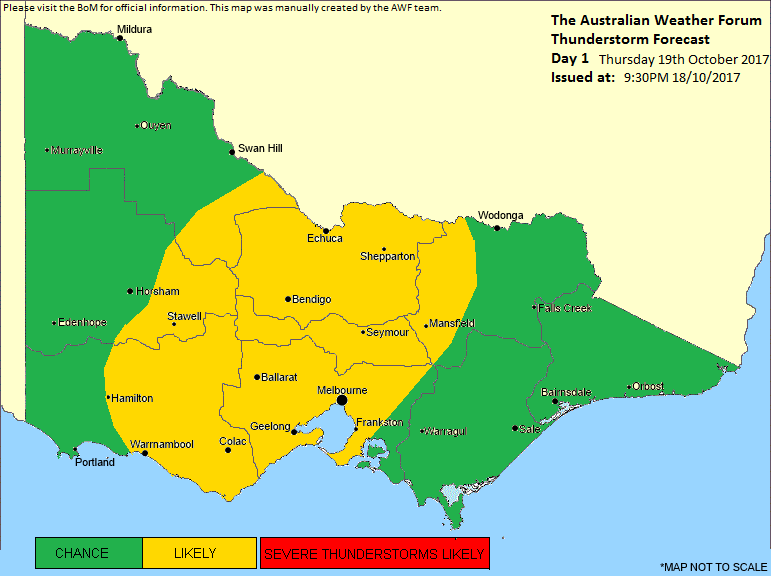
- Thunderstorm Forecast Day 1.png (51.56 KiB) Viewed 8811 times
Re: Victoria: Warm Spring Weather & Rainband: Oct 18-20 2017
Posted: Thu Oct 19, 2017 5:58 am
by Jake Smethurst
Some nice falls out in the west and southwest so far. These areas of rainfall should clear enough for further showers and storms to develop as the trough moves east during this afternoon. Hopefully some clearance in the clouds ...

Re: Victoria: Warm Spring Weather & Rainband: Oct 18-20 2017
Posted: Thu Oct 19, 2017 6:05 am
by hillybilly
Crazy warm out there and blowing a gale
City is already hotter than a typical mid summer arvo.
Radar looks good, but is slipping south a bit as expected. Will be a day of two parts with a rainband then a band of showers and storms of the arvo front. Not absolutely confident about totals as these types of systems usually yield winners and losers.
Some decent falls out west.
Re: Victoria: Warm Spring Weather & Rainband: Oct 18-20 2017
Posted: Thu Oct 19, 2017 7:53 am
by Horts
Melbourne metro not doing so well with this band, dumped it down for 10 minutes around 6:30 in Safety Beach, had a couple very brief showers on the drive to Mount Waverley, good early falls out west.
Melbourne, eastern and south eastern suburbs look like they getting rain shadowed hard, anything coming over looks to being torn apart as it his the Macedon Ranges. Hopefully improves for these areas as the day gets older, my garden needs a drink!
Re: Victoria: Warm Spring Weather & Rainband: Oct 18-20 2017
Posted: Thu Oct 19, 2017 8:02 am
by stevco123
The way I see things:
This IS the main trough coming through. Showers will increase to rain this morning with a rainband between 10 and 11, and all over by 1 to 2pm.
Very slight chance of storms (mainly embedded) in the metro area.
All clear after that with low cloud moving in once the wind swings to the southwest.
Ofcourse, this could change, but once again, unless there is clearance then unfortunately it is another potential storm day ruined. There's been too many of these the last few years. Cloud always seems to build up early capping any potential.
Re: Victoria: Warm Spring Weather & Rainband: Oct 18-20 2017
Posted: Thu Oct 19, 2017 8:24 am
by Hunter1890
Rain shadow working as mentioned which I understand is frustrating BUT don't get your hopes up! Some insane CAPE values forecast this arvo by a few models. I am 85% sure we will see a storm track over melbourne metro. Will be hit and miss but as Jake showed with the bom stormcast, some could organise and form a squall. North east vic looks set for a drenching! Either way I am very keen to see what happens from here!
~hunter
Re: Victoria: Warm Spring Weather & Rainband: Oct 18-20 2017
Posted: Thu Oct 19, 2017 8:28 am
by Gordon
Bursts of heavy rain here this morning totalling 5mm so far. Feels humid and stormy; temp 15C and not much wind for the last 24hrs unless I slept through it! Almost calm now. Odd patch of sun.
Re: Victoria: Warm Spring Weather & Rainband: Oct 18-20 2017
Posted: Thu Oct 19, 2017 9:08 am
by snowfall
Nothing here so far, with the rainshadow doing its thing. Sunny skies in fact, but maybe that will help for some extra heating later this morning ahead of the trough.
Re: Victoria: Warm Spring Weather & Rainband: Oct 18-20 2017
Posted: Thu Oct 19, 2017 9:09 am
by Skywalker
Wish I was down at my other place right now. The island is right in the firing line this morning.

Absolutely nothing happening here in the desert of course.

Re: Victoria: Warm Spring Weather & Rainband: Oct 18-20 2017
Posted: Thu Oct 19, 2017 9:21 am
by 93ben
I really need the rain in Malvern trying to keep the soil wet here at Cabrini Hospital is pretty hard.
Re: Victoria: Warm Spring Weather & Rainband: Oct 18-20 2017
Posted: Thu Oct 19, 2017 9:22 am
by tonycynic
Hoping it avoids Richmond for a while, need the dry when laying astroturf.
Also, anyone know what is happening with the Mildura radar, the composite is showing some heavy stuff but nothing on the close up.
Re: Victoria: Warm Spring Weather & Rainband: Oct 18-20 2017
Posted: Thu Oct 19, 2017 10:07 am
by stevco123
Just had a downpour, dumping 0.8mm!!!
Glad I watered the garden yesterday

Surely there's more in this than what's on offer at the moment? Hoping it''s not a fail.
Re: Victoria: Warm Spring Weather & Rainband: Oct 18-20 2017
Posted: Thu Oct 19, 2017 10:17 am
by James
hmm i want to know why its so warm, and moist in the atmosphere but no lightning happening anywhere according to tracker