MASSIVE!snowshow » Wed Jan 07, 2015 6:28 pm wrote:snowshow wrote:We just had an incredible storm here at Boolarra, we had torrential rain, largest hail I have ever seen in South Gippsland! Trees down everywhere!! One missed the house by 1/2 and inch19 mils in the gauge in 10mins

Welcome New Members! We want to hear from you. Register, stop lurking and start posting!
Hot and thundery - Tropical moisture feed - Jan 4 to 14 2015
-
mick

- Supercell
- Reactions:
- Posts: 1453
- Joined: Mon Nov 30, 2009 6:45 pm
- Location: Mid North SA Baaaaaaaaaaaaaaa
Re: Hot and thundery - Tropical moisture feed - Jan 4 to 13
Re: Hot and thundery - Tropical moisture feed - Jan 4 to 13
insane thunder and lightning to the north of us (pascoe vale). look out north east suburbs, check radar out, place is going to get smashed- viewbank, bundoora, macleod etc
- Geoff
- Supercell
- Reactions:
- Posts: 2538
- Joined: Tue Jul 05, 2011 9:46 pm
- Location: Olinda VIC (470m ASL)
Re: Hot and thundery - Tropical moisture feed - Jan 4 to 13
Well it was bound to happen with me out of the country for the first time in 9 years! 
Greetings from frosty England, enjoy the show, I'll be watching from here!
Greetings from frosty England, enjoy the show, I'll be watching from here!
AWF Rainfall Details - Monthly rainfall stats. Please post your totals here at the end of each month, thank you –
http://www.theaustralianweatherforum.co ... &start=180
http://www.theaustralianweatherforum.co ... &start=180
-
Australis(Shell3155)

- Supercell
- Reactions:
- Posts: 3146
- Joined: Mon Nov 30, 2009 8:05 pm
- Location: FTG
- Contact:
Re: Hot and thundery - Tropical moisture feed - Jan 4 to 13
7mm from 2pm.
the Sky in the North West is looking like a picture, clouds building with the sunlight behind making them glow amazing white.
snowshow.. OMG..
Kinda glad ya went Geoff.... hehehe...
the Sky in the North West is looking like a picture, clouds building with the sunlight behind making them glow amazing white.
snowshow.. OMG..
Kinda glad ya went Geoff.... hehehe...
-
mick
- Supercell
- Reactions:
- Posts: 1453
- Joined: Mon Nov 30, 2009 6:45 pm
- Location: Mid North SA Baaaaaaaaaaaaaaa
Re: Hot and thundery - Tropical moisture feed - Jan 4 to 13
Currently watching weak lowering and roatation of lot near mt dandy.
- Nick Sykes
- Cumulonimbus
- Reactions:
- Posts: 353
- Joined: Wed Nov 25, 2009 6:16 pm
- Location: Gungahlin, ACT
Re: Hot and thundery - Tropical moisture feed - Jan 4 to 13
Hey all,
Moved to Canberra yesterday so was always bound to see an epic event. enjoy
Nick
Moved to Canberra yesterday so was always bound to see an epic event. enjoy
Nick
- stevco123
- Supercell
- Reactions:
- Posts: 2936
- Joined: Sat Aug 07, 2010 7:42 pm
- Location: Cranbourne 78m asl
Re: Hot and thundery - Tropical moisture feed - Jan 4 to 13
So far today i missed the acrion by less than 10 kilometers each way south and north.
So annoyed
So annoyed
https://www.weatherlink.com/bulletin/53 ... 76dd68e8bc: for current weather updated every 2 minutes
-
mick
- Supercell
- Reactions:
- Posts: 1453
- Joined: Mon Nov 30, 2009 6:45 pm
- Location: Mid North SA Baaaaaaaaaaaaaaa
Re: Hot and thundery - Tropical moisture feed - Jan 4 to 13
Got flangs all around me few spots of rain, 12 deg
temp
drop.
temp
drop.
Re: Hot and thundery - Tropical moisture feed - Jan 4 to 13
Welcome to Canberra Nick! Hopefully storms & everything else we have to offer up here make it a worthwhile move
- Skywalker
- Supercell
- Reactions:
- Posts: 1872
- Joined: Sun Nov 29, 2009 10:03 am
- Location: Burnside Heights/Cowes (Home) & Sunshine West (Work)
Re: Hot and thundery - Tropical moisture feed - Jan 4 to 13
STILL nothing here! The wait continues.... 

Caroline Springs, Melbourne's meteorological boredom zone.
- droughtbreaker
- Supercell
- Reactions:
- Posts: 2844
- Joined: Wed Nov 25, 2009 7:50 pm
- Location: Mount Macedon, VIC, 520m asl
Re: Hot and thundery - Tropical moisture feed - Jan 4 to 13
It all went off like a bomb around 5pm after what was a very hot and sunny day with little development up until that point. 37C here which is about 2C above what was forecast. Tomorrow is going to seriously erupt as I don't think surface heating and clear air is going to matter with the approaching trough and intense tropical moisture, especially with and following the trough itself.
Just 0.8mm here today on the very edge of the storms. Unfortunately, with the hotter day than forecast, a little windier than I thought was expected, and the 'pulsey' nature of the storms (which also kicked up a few minor wind squalls here), fires were started on the edge of the cells where rain did not fall. Quite a few around here that seem to have been dealt with very quickly, but a different story up north of Kyneton by the looks of things.
Just had a fire fighting aircraft fly low over us on the way back from the fire, so it's a full scale operation up there now.
It's a steamy and cloudy 23C here atm.
As for the coming system/s, still a multi stage event for all the major models. GFS has around 25mm-50mm but EC still 50mm-100mm for central. It's still 'on' at this stage which is good.
- Dane
- Supercell
- Reactions:
- Posts: 1661
- Joined: Thu Nov 26, 2009 9:51 am
- Location: Sebastopol 420m ASL
- Contact:
Re: Hot and thundery - Tropical moisture feed - Jan 4 to 13
To far to the south this afternoon and to far to the North this evening.
Never the less getting a great lightning display from the storms to the south and SW and the occasional dull rumble.
Plenty of Cc lightning and quite a few Cg's, at times its like a strobe light to the south very frequent lightning.
Getting some strong outflow winds from those storms recorded a 26 knot (48kph) gust from the SSW about 30 mins ago.
Hopefully we get some rain here tomorrow.
- snowshow
- Cumulus
- Reactions:
- Posts: 64
- Joined: Tue Jun 07, 2011 11:42 am
- Location: Boolarra South/Mirboo North
Re: Hot and thundery - Tropical moisture feed - Jan 4 to 13
Radar lighting up again for this area
- Stone Free
- Cumulus
- Reactions:
- Posts: 25
- Joined: Tue Dec 15, 2009 9:01 am
- Location: Reservoir, Victoria
Re: Hot and thundery - Tropical moisture feed - Jan 4 to 13
So when will the sea breeze die off and allow these storms to penetrate the metro area?
- Gordon
- Supercell
- Reactions:
- Posts: 2890
- Joined: Thu Jun 17, 2010 10:01 am
- Location: Near Gordon, Vic. 620 m asl
Re: Hot and thundery - Tropical moisture feed - Jan 4 to 13
Very heavy bursts of rain here now but surprisingly, no lightning/thunder with it - yet.
- Twiggy
- Cumulus
- Reactions:
- Posts: 67
- Joined: Wed Nov 09, 2011 6:19 pm
- Location: Loddon Valley, Bears Lagoon.
Re: Hot and thundery - Tropical moisture feed - Jan 4 to 13
Heavy shower here.... But nothing to be excited about. Looking forward to the weekend. Will not be here though, heading up to Dubbo!!! Seems there may be something happening on Sunday, so we will see how we go Will be haring the excitement over the phone from her bring on the sheep feed!!!
- Jake Smethurst
- Supercell
- Reactions:
- Posts: 3583
- Joined: Mon Nov 23, 2009 8:49 pm
- Location: Cheltenham
Re: Hot and thundery - Tropical moisture feed - Jan 4 to 13
As expected the development is continuing into the evening. I think it will be on and off all night before redeveloping with tomorrow's severe activity.
Anyway, I drove down to a lovely viewpoint over the bay to see that very intense line of thunderstorms pass to our south. I took a few pics which I'll post here below (click for bigger). There was plenty of lightning also, nearly every couple of seconds, and it was a brilliant mix of CG to CC and the odd CA. I'll post a short video of it below too. Conditions were very calm until about half way through our viewing when the outflow from the storms hit us ... it was intense! Definitely would have been gusting to 50-60 km/h. Blew a few umbrellas and stuff away from the beach below.
Video of the lightning: https://www.facebook.com/video.php?v=86 ... =2&theater
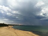
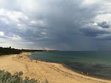
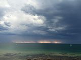
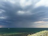
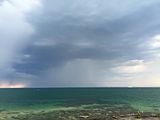


Jake - Senior AWF Forecaster
Feel free to send me a private message if you have any questions.
Feel free to send me a private message if you have any questions.
- Jake Smethurst
- Supercell
- Reactions:
- Posts: 3583
- Joined: Mon Nov 23, 2009 8:49 pm
- Location: Cheltenham
Re: Hot and thundery - Tropical moisture feed - Jan 4 to 13
Getting a nice little storm here. Loud thunder and some pretty close lightning. Heavy burst of rain for a few mins.
Jake - Senior AWF Forecaster
Feel free to send me a private message if you have any questions.
Feel free to send me a private message if you have any questions.
- BigBen
- Cumulonimbus
- Reactions:
- Posts: 135
- Joined: Tue Dec 08, 2009 10:16 am
- Location: Glen Huntly (home) Richmond (work)
Re: Hot and thundery - Tropical moisture feed - Jan 4 to 13
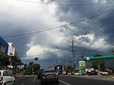
Some big build up on the radar near Bacchus Marsh, looks like it's aiming for Tarneit and Point Cook, hoping to see a decent light show.
- WeatherViewer
- Cumulonimbus
- Reactions:
- Posts: 388
- Joined: Fri Oct 19, 2012 5:57 pm
- Location: Truganina
Re: Hot and thundery - Tropical moisture feed - Jan 4 to 13
Yep Plenty of thunder and lightening out this way. I'm in Wyndham Vale, the rain is here. Bring it on!BigBen wrote:Some big build up on the radar near Bacchus Marsh, looks like it's aiming for Tarneit and Point Cook, hoping to see a decent light show.