
Welcome New Members! We want to hear from you. Register, stop lurking and start posting!
Sydney/NSW: Day to Day Weather Talk
Forum rules
When posting photos, particularly in active breaking weather threads, please link to clickable photos to minimise download issues. For more information, see Posting Photo Guidelines for more information. Threads that are six weeks old or older will be Archived Here
When posting photos, particularly in active breaking weather threads, please link to clickable photos to minimise download issues. For more information, see Posting Photo Guidelines for more information. Threads that are six weeks old or older will be Archived Here
- Lily
- Supercell
- Reactions:
- Posts: 4014
- Joined: Wed Nov 25, 2009 10:29 pm
- Location: Rowville/Lysterfield
Re: NSW/ACT: Day to Day Weather Talk
Woah, that's strong! Wonder if there's many campers out amongst it in this sort of weather (being school holidays and all)? There were a few at Eildon last weekend (crazy campers lol!).
-
apocalypse

- Cumulonumbus Calvas
- Reactions:
- Posts: 761
- Joined: Tue Jan 19, 2010 6:17 pm
- Location: Wagga Wagga, NSW 189m asl
Re: NSW/ACT: Day to Day Weather Talk
Wow, I haven't been on for a while, with the next uni semester starting and the internet going so slow. I think it's time for a post. 
Winds of change turning NSW around
Brett Dutschke, Monday July 25, 2011 - 10:37 EST
A wind change is giving New South Wales a fortnight of two halves, especially on the coast, where torrential rain and strong winds have given way to the warmth of the sun.
Last week 200 millimetres of rain and 90km/h southerlies pummelled the Hunter, Sydney and Illawarra, and the temperature didn't even reach the mid-teens on some days. At the same time, western NSW was bathing in rare sunny winter warmth.
The weather is now performing a 180-degree turnaround, with the west getting some rain and the coast some warmer sunshine.
Western NSW won't be nearly as wet as the coast was, but cloud, showers and colder westerly winds are bringing a much more gloom than last week, at least in the south.
Wagga Wagga is now struggling to reach 10 degrees in the rain after warming to 18 last week in the sun.
The unstable westerlies bringing the showers are losing oomph as they reach the coast, so skies are showing lengthy sunny spells.
Apart from a few showers mid-week, the coast, including Sydney, will be mostly sunny through to the weekend. It will warm to the high teens and low twenties, as much as seven degrees warmer than last week's wettest days. Washing machines will be running hot.
- Weatherzone
© Weatherzone 2011
Nathan Morris
2013 Rainfall
Jan - 3.8mm
Feb - 27.0mm
Mar - 0.0mm
YTD - 30.8mm
2013 Rainfall
Jan - 3.8mm
Feb - 27.0mm
Mar - 0.0mm
YTD - 30.8mm
-
crikey

- Supercell
- Reactions:
- Posts: 1314
- Joined: Mon Feb 07, 2011 8:02 pm
- Location: tweed shire NSW and nDUNOLLY.. Nth Central district VIC
- Contact:
Re: NSW/ACT: Day to Day Weather Talk
Hi Apocalypse. Great to have you back posting. Enjoy your posts.  Appreciate what you do especially because you are studying at uni'
Are you studying to be a meteorologist?
Are you studying to be a meteorologist?
-
apocalypse
- Cumulonumbus Calvas
- Reactions:
- Posts: 761
- Joined: Tue Jan 19, 2010 6:17 pm
- Location: Wagga Wagga, NSW 189m asl
Re: NSW/ACT: Day to Day Weather Talk
Thanks for saying that Crikey. I'm glad that you enjoy my posts. 
I'm majoring in maths and physics, and yes, hopefully I can get a job at the bureau!
I'm majoring in maths and physics, and yes, hopefully I can get a job at the bureau!
Nathan Morris
2013 Rainfall
Jan - 3.8mm
Feb - 27.0mm
Mar - 0.0mm
YTD - 30.8mm
2013 Rainfall
Jan - 3.8mm
Feb - 27.0mm
Mar - 0.0mm
YTD - 30.8mm
-
apocalypse
- Cumulonumbus Calvas
- Reactions:
- Posts: 761
- Joined: Tue Jan 19, 2010 6:17 pm
- Location: Wagga Wagga, NSW 189m asl
Re: NSW/ACT: Day to Day Weather Talk
Loving this cloud cover after the sunny streak we've been having.
The models have some good rainfall on Wednesday night and Thursday, if GFS is right I'll be happy (between 50-75mm for the last few runs). Will be good to get some water running through the systems again after the last 4 months of below average rain. And most importantly, into the lawn!!
The models have some good rainfall on Wednesday night and Thursday, if GFS is right I'll be happy (between 50-75mm for the last few runs). Will be good to get some water running through the systems again after the last 4 months of below average rain. And most importantly, into the lawn!!
Nathan Morris
2013 Rainfall
Jan - 3.8mm
Feb - 27.0mm
Mar - 0.0mm
YTD - 30.8mm
2013 Rainfall
Jan - 3.8mm
Feb - 27.0mm
Mar - 0.0mm
YTD - 30.8mm
-
crikey
- Supercell
- Reactions:
- Posts: 1314
- Joined: Mon Feb 07, 2011 8:02 pm
- Location: tweed shire NSW and nDUNOLLY.. Nth Central district VIC
- Contact:
Re: NSW/ACT: Day to Day Weather Talk
Apocalypse
Are you going to run a 'special' thread for an ECL on the coast ? or is that not clear yet?
Nice to see your back . Hope studies are going well.
You need good enter scores to get into science at uni' ,so good you've got your priorities in order
Are you going to run a 'special' thread for an ECL on the coast ? or is that not clear yet?
Nice to see your back
You need good enter scores to get into science at uni' ,so good you've got your priorities in order
-
crikey
- Supercell
- Reactions:
- Posts: 1314
- Joined: Mon Feb 07, 2011 8:02 pm
- Location: tweed shire NSW and nDUNOLLY.. Nth Central district VIC
- Contact:
Re: NSW/ACT: Day to Day Weather Talk
SEVERE THUNDERSTORM WARNING
for LARGE HAILSTONES
For people in the
Mid North Coast and parts of the
Hunter and
Northern Tablelands Forecast Districts.
Issued at 3:07 pm Thursday, 8 September 2011.
Severe thunderstorms are likely to produce large hailstones in the warning area over the next several hours. Locations which may be affected include Laurieton, Taree, Dorrigo and Ebor.
-----------------------------------------------------------
There are storms cells present along a trough line that extends across Queensland and into the N/Eastern parts of NSW atm ( 3.30pm observation)
http://www.weatherzone.com.au/stormtrac ... ja=v&lya=1" onclick="window.open(this.href);return false;
http://www.weatherzone.com.au/synoptic.jsp?d=0&c=satsyn" onclick="window.open(this.href);return false;
The storms appear to be scattered along a cloud front moving east/Southeast along with frontal rain band.
In NSW that storm /rainband is already approaching the northern NSW coastline
-
crikey
- Supercell
- Reactions:
- Posts: 1314
- Joined: Mon Feb 07, 2011 8:02 pm
- Location: tweed shire NSW and nDUNOLLY.. Nth Central district VIC
- Contact:
Re: NSW/ACT: Day to Day Weather Talk
Well the expected Tasman low hasn't even formed yet and here are some rainfall totals from yesterdays cloud band that streamed across many parts of NSW yesterday( Thursday 8th sept 2011)
A persistent cloud band brought a continual stream from rain band from the NW.
A long trough region extending over many districts in NSW , persisted in a similar position for the day
6 forecast districts had every station recording some rain.. from BOM observations
http://www.bom.gov.au/nsw/observations/nswall.shtml" onclick="window.open(this.href);return false;
. The broad area of rainfall indicates the width of the trough region and its length across the state.A few of the larger totals in the state below
HUNTER..All stations had rain
Merriwa..32.2mm
Murrundindi gap..28mm
Scone..19.8mm
Sydney Metropolitan..All stations recorded something
Bankstown 13.6mm
Illawarra
Most stations had recorded rainfall
Central Tablelands..All stations recording rainfall
Mudgee ..26mm
Nullo Mountain 43mm
Northwest slopes
All stations had rainfall recorded
Gunnedah..37.2mm
Narrabri..35.6mm
Tamworth..39.6mm
Central west All stations recorded some rain
Coonabarabran..27.8mm
Coonamble..25.mm
Upper western All stations recorded some rain
Bourke..15.8mm
And now the most interesting watch is the development of a low in the tasman and some cold windy southerlies over the coming days. Livinias weather last night suggested that the coastline regions in NSW could all get some more reasonable rainfall.
NSW is a good weather watch atm. Also for potential snow on the Alps
-
apocalypse
- Cumulonumbus Calvas
- Reactions:
- Posts: 761
- Joined: Tue Jan 19, 2010 6:17 pm
- Location: Wagga Wagga, NSW 189m asl
Re: NSW/ACT: Day to Day Weather Talk
Australian Government Bureau of Meteorology
New South Wales
Severe Weather Warning
for damaging winds
for people in the Lower Western and Snowy Mountains forecast districts.
Issued at 6:06 am EST on Monday 19 September 2011.
Weather Situation
A high lies over the Tasman Sea, while a low pressure trough and associated
cold front approach from the west. An increasing northwesterly airstream is
developing between these two systems. The front is expected to reach the far
west of New South Wales later this afternoon.
Damaging winds averaging 40 to 60 km/h with peak gusts around 90 km/h are
forecast for western parts of the Lower Western forecast district this
afternoon. Locations that may be affected include Broken Hill, Pooncarie, and
Wentworth.
Damaging winds averaging 50 to 65 km/h with peak gusts around 90 km/h are
forecast for exposed parts of the Snowy Mountains forecast district tonight and
early Tuesday.
The State Emergency Service advises that people should:
- Move vehicles under cover or away from trees.
- Secure or put away loose items around your house, yard and balcony.
- Keep clear of fallen power lines.
For emergency help in floods and storms, ring your local SES Unit on 132 500.
The next warning will be issued by 11:00 am EST Monday.
This warning is also available through TV and Radio broadcasts; the Bureau's
website at http://www.bom.gov.au" onclick="window.open(this.href);return false; or call 1300 659 218.
The Bureau and State Emergency Service would appreciate this warning being
broadcast regularly.
Nathan Morris
2013 Rainfall
Jan - 3.8mm
Feb - 27.0mm
Mar - 0.0mm
YTD - 30.8mm
2013 Rainfall
Jan - 3.8mm
Feb - 27.0mm
Mar - 0.0mm
YTD - 30.8mm
-
apocalypse
- Cumulonumbus Calvas
- Reactions:
- Posts: 761
- Joined: Tue Jan 19, 2010 6:17 pm
- Location: Wagga Wagga, NSW 189m asl
Re: NSW/ACT: Day to Day Weather Talk
Australian Government Bureau of Meteorology
New South Wales
Severe Weather Warning
for damaging winds and destructive winds
for people in the Riverina and Snowy Mountains forecast districts.
Issued at 6:43 pm EST on Monday 19 September 2011.
Weather Situation
A cold front lies from Fowler's Gap to about Swan Hill and is expected to
extend from about Deniliquin to Tibooburra at 9 pm. Strong gusty northwesterly
winds are ahead of the change, gradually easing behind the change.
Destructive winds averaging 50 km/h with peak gusts around 100 km/h are
possible for parts of the Snowy Mountains forecast district tonight and early
Tuesday.
Alpine Peaks may experience winds averaging 80 km/h with peak gusts around 125
km/h
Damaging winds averaging 30 km/h with peak gusts around 90 km/h are forecast
for parts of the Riverina forecast district this evening.
The severe weather warning for parts of the Lower Western forecast district has
been cancelled, but the situation will continue to be monitored and further
warnings will be issued if necessary.
The State Emergency Service advises that people should:
- Move vehicles under cover or away from trees.
- Secure or put away loose items around your house, yard and balcony.
- Keep clear of fallen power lines.
- Don't drive, ride or walk through flood water.
- Keep clear of creeks and storm drains.
- Beware of fallen trees or debris on the road.
For emergency help in floods and storms, ring your local SES Unit on 132 500.
The next warning will be issued by 11:00 pm EST Monday.
This warning is also available through TV and Radio broadcasts; the Bureau's
website at http://www.bom.gov.au" onclick="window.open(this.href);return false; or call 1300 659 218.
The Bureau and State Emergency Service would appreciate this warning being
broadcast regularly.
Nathan Morris
2013 Rainfall
Jan - 3.8mm
Feb - 27.0mm
Mar - 0.0mm
YTD - 30.8mm
2013 Rainfall
Jan - 3.8mm
Feb - 27.0mm
Mar - 0.0mm
YTD - 30.8mm
-
apocalypse
- Cumulonumbus Calvas
- Reactions:
- Posts: 761
- Joined: Tue Jan 19, 2010 6:17 pm
- Location: Wagga Wagga, NSW 189m asl
Re: NSW/ACT: Day to Day Weather Talk
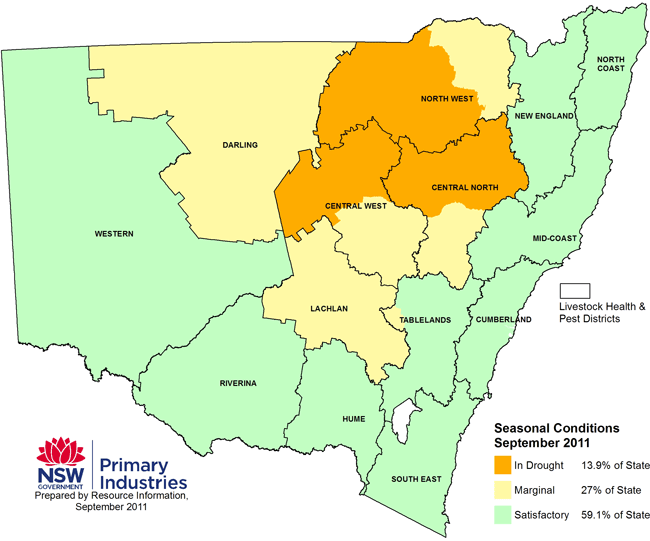
Central NSW 'back in drought'
Thursday September 22, 2011 - 11:13 EST
More than half of the area covered by the Central West and Central North Livestock Health and Pest Authorities in New South Wales has moved back into drought.
The latest condition report from the State Government says areas including Tamworth, Nyngan, Coonamble and Trangie have declined after receiving patchy rainfall last month.
The rest of the LHPAs are considered marginal.
Central West LHPA general manager Narelle Rodway says the warm days and hot winds are drying out winter crops.
"Without some significant rain coming in the very near future I think we're going to see significant loss of yields," Ms Rodway said.
"Already we've gone from this time last year an expected 14 million tonnes of grain and oil seed, and now the Department of Primary Industries is estimating that at just over 10 million tonnes."
Ms Rodway says below average rainfall is having an impact.
"We've got our summer coming on very fast. I have seen some stock on crops and there's quite a lot of people who are hand feeding grain out to their stock now," she said.
"I can only imagine how primary producers must be feeling this year.
"Things looked quite bright there for a moment when we had some good rains over the Christmas, New Year period but then everything just seemed to dry up and we've had very little since then."
- ABC
© ABC 2011
Sourced from http://www.dpi.nsw.gov.au/agriculture/e ... rea-2011-9" onclick="window.open(this.href);return false;
Nathan Morris
2013 Rainfall
Jan - 3.8mm
Feb - 27.0mm
Mar - 0.0mm
YTD - 30.8mm
2013 Rainfall
Jan - 3.8mm
Feb - 27.0mm
Mar - 0.0mm
YTD - 30.8mm
-
apocalypse
- Cumulonumbus Calvas
- Reactions:
- Posts: 761
- Joined: Tue Jan 19, 2010 6:17 pm
- Location: Wagga Wagga, NSW 189m asl
Re: NSW/ACT: Day to Day Weather Talk
Just discovered the 1st was the coldest October day since 1976. New goal: coldest on record!
Nathan Morris
2013 Rainfall
Jan - 3.8mm
Feb - 27.0mm
Mar - 0.0mm
YTD - 30.8mm
2013 Rainfall
Jan - 3.8mm
Feb - 27.0mm
Mar - 0.0mm
YTD - 30.8mm
-
apocalypse
- Cumulonumbus Calvas
- Reactions:
- Posts: 761
- Joined: Tue Jan 19, 2010 6:17 pm
- Location: Wagga Wagga, NSW 189m asl
Re: NSW/ACT: Day to Day Weather Talk
A few cells developing to the north and south of here (and nothing in between  ), with moderate rainfall intensities. Wasn't expecting much today, certainly not this early, so we might end up with something by the end of the day.
Nathan Morris
2013 Rainfall
Jan - 3.8mm
Feb - 27.0mm
Mar - 0.0mm
YTD - 30.8mm
2013 Rainfall
Jan - 3.8mm
Feb - 27.0mm
Mar - 0.0mm
YTD - 30.8mm
-
apocalypse
- Cumulonumbus Calvas
- Reactions:
- Posts: 761
- Joined: Tue Jan 19, 2010 6:17 pm
- Location: Wagga Wagga, NSW 189m asl
Re: NSW/ACT: Day to Day Weather Talk
Dew point just keeps going up and up, currently at 23.9/14.6 which gives a CAPE value of 642 and -1.89 LI.
Towers going up all around now!
Towers going up all around now!
Nathan Morris
2013 Rainfall
Jan - 3.8mm
Feb - 27.0mm
Mar - 0.0mm
YTD - 30.8mm
2013 Rainfall
Jan - 3.8mm
Feb - 27.0mm
Mar - 0.0mm
YTD - 30.8mm
-
crikey
- Supercell
- Reactions:
- Posts: 1314
- Joined: Mon Feb 07, 2011 8:02 pm
- Location: tweed shire NSW and nDUNOLLY.. Nth Central district VIC
- Contact:
Re: NSW/ACT: Day to Day Weather Talk
I thought tomorow afternoon ( tuesday 25th Oct 2011.. about 4pm ish.. Giving some lee way for timing) ,would be very a very good weather watch along the NSW coastline.
Some very interesting wind patterns on BOM wind forecast
http://www.bom.gov.au/jsp/watl/wind/index.jsp" onclick="window.open(this.href);return false;
Northerlies coming down the northern coastline off the Tasman sea
Southerlies coming up from the southern NSW coastline.
Resulting in a strong area of convergence ( tight troughy set up, l think)
looks quite bizzare actually.
A clockwise rotation of airstream over all of NSW ( low pressure area)
Pretty much there is a strong convergence line right along the whole of the NSW coastline. Interesting to watch outcome?
I can't make up my mind which would be more dramatic. The Northern coast of NSW with moist northerlies or down around Canberra way , where southerlies from the ocean meet inland air from inland NSW?
Anyway the wind pattern is extraordinary.
-
apocalypse
- Cumulonumbus Calvas
- Reactions:
- Posts: 761
- Joined: Tue Jan 19, 2010 6:17 pm
- Location: Wagga Wagga, NSW 189m asl
Re: NSW/ACT: Day to Day Weather Talk
This is good to hear.
Flood funds flow to Wagga
Friday November 4, 2011 - 14:01 EDT
More than $150,000 in funding has been announced for Wagga City Council after the floods in October last year.
The Member for Wagga, Daryl Maguire, has announced the grant, to cover the cost of clean-up and repairs to public infrastructure.
"The grant will also cover repairs to walkways and lighting at the botanic gardens and restoration of recreation facilities at Wiradjuri Reserve, Tarcutta and Rawlings Park, along with works at the beach and Wollundry Lagoon.
The New South Wales Government says the funding is in addition to the substantial financial help by the former Roads and Traffic Authority for damage to council roads and bridges.
- ABC
© ABC 2011
Nathan Morris
2013 Rainfall
Jan - 3.8mm
Feb - 27.0mm
Mar - 0.0mm
YTD - 30.8mm
2013 Rainfall
Jan - 3.8mm
Feb - 27.0mm
Mar - 0.0mm
YTD - 30.8mm
-
apocalypse
- Cumulonumbus Calvas
- Reactions:
- Posts: 761
- Joined: Tue Jan 19, 2010 6:17 pm
- Location: Wagga Wagga, NSW 189m asl
Re: NSW/ACT: Day to Day Weather Talk
I've got a good feeling about today. The rain band developed in a line from NW to SE Victoria like I expected, and storms should fire up ahead of this in the hot and humid airmass. Lots of clear air ahead of this band. Trough in perfect position too.
Nathan Morris
2013 Rainfall
Jan - 3.8mm
Feb - 27.0mm
Mar - 0.0mm
YTD - 30.8mm
2013 Rainfall
Jan - 3.8mm
Feb - 27.0mm
Mar - 0.0mm
YTD - 30.8mm
-
apocalypse
- Cumulonumbus Calvas
- Reactions:
- Posts: 761
- Joined: Tue Jan 19, 2010 6:17 pm
- Location: Wagga Wagga, NSW 189m asl
Re: NSW/ACT: Day to Day Weather Talk
Looks like generally unstable conditions for the rest of the week, especially towards the end into the Christmas period. GFS has 75mm on Christmas Day!!
We had 55mm on Xmas Day '09 (also my birthday ). It always seems to be wet or cooler than normal at Christmas, which is fine by me, but I bet the people going outdoors wouldn't agree!
We had 55mm on Xmas Day '09 (also my birthday
Nathan Morris
2013 Rainfall
Jan - 3.8mm
Feb - 27.0mm
Mar - 0.0mm
YTD - 30.8mm
2013 Rainfall
Jan - 3.8mm
Feb - 27.0mm
Mar - 0.0mm
YTD - 30.8mm
- Lily
- Supercell
- Reactions:
- Posts: 4014
- Joined: Wed Nov 25, 2009 10:29 pm
- Location: Rowville/Lysterfield
Re: NSW/ACT: Day to Day Weather Talk
Oh now, you don't want that much rain Christmas Day. Perhaps at night to soothe you to sleep lol? Or the next day! But not Christmas Day, wet Christmas' aren't very nice lol.
-
apocalypse
- Cumulonumbus Calvas
- Reactions:
- Posts: 761
- Joined: Tue Jan 19, 2010 6:17 pm
- Location: Wagga Wagga, NSW 189m asl
Re: NSW/ACT: Day to Day Weather Talk
Just emptied the gauge to find 64.5mm!! Amazing stuff.
From basically nothing, to way past the monthly average! It's funny how things turn out.
I didn't go to sleep after watching the tennis final which finished at 1:30. My whole night has basically been - front door, look at rain .. computer, look at radar. LOL
From basically nothing, to way past the monthly average! It's funny how things turn out.
I didn't go to sleep after watching the tennis final which finished at 1:30. My whole night has basically been - front door, look at rain .. computer, look at radar. LOL
Nathan Morris
2013 Rainfall
Jan - 3.8mm
Feb - 27.0mm
Mar - 0.0mm
YTD - 30.8mm
2013 Rainfall
Jan - 3.8mm
Feb - 27.0mm
Mar - 0.0mm
YTD - 30.8mm