Welcome New Members! We want to hear from you. Register, stop lurking and start posting!

Stormy Period - Nov 29th - Dec 9th 2014

Archived Weather Events since 2009.
If you have any valuable content to add to any locked thread, please PM board moderator.
s
stevco123
Supercell
Reactions:
Posts: 2936
Joined: Sat Aug 07, 2010 7:42 pm
Location: Cranbourne 78m asl

Re: Stormy Period - Nov 29th - Dec 9th 2014

Post by stevco123 »

johnno » Sat Dec 06, 2014 10:06 am wrote:
johnno wrote:I highly doubt that Stevco.

20mm since 9am in Cerberus!
Cerberus is hardly Melbourne metro.

But anyway, I'm hoping by saying it will be dry, it will in fact p++s down.

Not liking the look of the radar but. Skirting around the metro area. Depends where the low goes.

Here's hoping.
https://www.weatherlink.com/bulletin/53 ... 76dd68e8bc: for current weather updated every 2 minutes
j
johnno
Supercell
Reactions:
Posts: 3449
Joined: Mon Nov 30, 2009 8:49 am
Location: Ascot Vale

Re: Stormy Period - Nov 29th - Dec 9th 2014

Post by johnno »

2 different topics, I was replying to what you said and then changed the subject and pointed out that Cerberus has had a lot of rain in such a short amount of time.
G
Geoff
Supercell
Reactions:
Posts: 2538
Joined: Tue Jul 05, 2011 9:46 pm
Location: Olinda VIC (470m ASL)

Re: Stormy Period - Nov 29th - Dec 9th 2014

Post by Geoff »

Okay, I give up! In two hours it's gone from looking like a wet day, to brightening up with hazy sun and no rain on the radar heading my way????? :?
AWF Rainfall Details - Monthly rainfall stats. Please post your totals here at the end of each month, thank you
http://www.theaustralianweatherforum.co ... &start=180
s
stevco123
Supercell
Reactions:
Posts: 2936
Joined: Sat Aug 07, 2010 7:42 pm
Location: Cranbourne 78m asl

Re: Stormy Period - Nov 29th - Dec 9th 2014

Post by stevco123 »

johnno » Sat Dec 06, 2014 10:19 am wrote:
johnno wrote:2 different topics, I was replying to what you said and then changed the subject and pointed out that Cerberus has had a lot of rain in such a short amount of time.

My bad. Sorry for that.
https://www.weatherlink.com/bulletin/53 ... 76dd68e8bc: for current weather updated every 2 minutes
User avatar
Rivergirl
Memorial
Reactions:
Posts: 3674
Joined: Sun Nov 22, 2009 6:04 pm
Location: Ferny Creek VIC
Contact:

Re: Stormy Period - Nov 29th - Dec 9th 2014

Post by Rivergirl »

TOP PRIORITY FOR IMMEDIATE BROADCAST

SEVERE THUNDERSTORM WARNING

for DAMAGING WIND, HEAVY RAINFALL and LARGE HAILSTONES

For people in the
North East and parts of the
East Gippsland and
West and South Gippsland Forecast Districts.
Issued at 11:19 am Saturday, 6 December 2014.
Severe thunderstorms are likely to produce damaging winds, heavy rainfall that may lead to flash flooding and large hailstones in the warning area over the next several hours. Locations which may be affected include Wodonga, Corryong, Bright, Falls Creek, Mt Buller and Omeo.
The State Emergency Service advises that people should:
* Keep clear of fallen power lines.
* secure any loose objects in the vicinity of your home.
* keep away from creeks and drains.
* do not drive vehicles through flooded areas.
* stay indoors if possible.
* Avoid using the phone during the storm.
* if you are outside, avoid sheltering under trees
* listen to the radio for storm updates
* switch off your computer and electrical appliances

The next warning is due to be issued by 2:20 pm.
Warnings are also available through TV and Radio broadcasts, the Bureau's website at http://www.bom.gov.au" onclick="window.open(this.href);return false; or call 1300 659 217. The Bureau and State Emergency Service would appreciate warnings being broadcast regularly.

Image
W
Wilko
Supercell
Reactions:
Posts: 1492
Joined: Wed Aug 11, 2010 12:08 pm
Location: Moorabbin & Highett, Vic

Re: Stormy Period - Nov 29th - Dec 9th 2014

Post by Wilko »

Sky weather mentioned 2 seperate weather events
Today was influenced by an upper level trough pushing up from Southwest
Them tomorrow it combines with the developing low in Eastern Victoria pushing down to Tassie
According to their reports becomes awfully close to Melbourne in can dump quite a bit of rain tomorrow
That's just going by their reports
I have no idea but guessing big falls in the east and I wouldn't discount Melbourne at all with the low track Southwest
W
Wilko
Supercell
Reactions:
Posts: 1492
Joined: Wed Aug 11, 2010 12:08 pm
Location: Moorabbin & Highett, Vic

Re: Stormy Period - Nov 29th - Dec 9th 2014

Post by Wilko »

Also please stay safe everyone is some of the storms are severe
Yarrawonga radar is just unbelievable
n
nafets
Supercell
Reactions:
Posts: 1324
Joined: Mon Jan 04, 2010 6:10 pm
Location: Ascot vale

Re: Stormy Period - Nov 29th - Dec 9th 2014

Post by nafets »

Yeah wilko, Yarrawonga radar is exploding, with storms forming in a line moving SW there could well be some flash flooding! Wangaratta has picked up 10mm in short time.

EDIT: 51mm in Wangaratta and still pouring
Go the bombersss!
s
stevco123
Supercell
Reactions:
Posts: 2936
Joined: Sat Aug 07, 2010 7:42 pm
Location: Cranbourne 78m asl

Re: Stormy Period - Nov 29th - Dec 9th 2014

Post by stevco123 »

Very, very frustrating. I know it is the norm for the North-East to get smashed with storms whilst Melbourne misses out, but c'mon... we need something. Almost 2 weeks of no action or very limited.
https://www.weatherlink.com/bulletin/53 ... 76dd68e8bc: for current weather updated every 2 minutes
J
Jake Smethurst
Supercell
Reactions:
Posts: 3583
Joined: Mon Nov 23, 2009 8:49 pm
Location: Cheltenham

Re: Stormy Period - Nov 29th - Dec 9th 2014

Post by Jake Smethurst »

The Australian Weather Forum
SEVERE THUNDERSTORM ADVICE
Please use Bureau of Meteorology warnings for official purposes

A very dangerous thunderstorm is evident on radar to the north of Dookie. This thunderstorm is likely a supercell thunderstorm meaning extremely severe conditions are possible. This particular thunderstorm cell has the high potential to cause large hailstones, flash flooding and destructive winds. Latest doppler imaging indicates damaging to destructive winds are already occurring within this thunderstorm complex. Please also note, Wangaratta in Victoria has received 52mm of rain in just 40 minutes from this thunderstorm.

NUMURKAH, SHEPPARTON and SURROUNDING AREAS are likely to be impacted from this thunderstorm over the next hour.
Jake - Senior AWF Forecaster
Feel free to send me a private message if you have any questions.
d
droughtbreaker
Supercell
Reactions:
Posts: 2844
Joined: Wed Nov 25, 2009 7:50 pm
Location: Mount Macedon, VIC, 520m asl

Re: Stormy Period - Nov 29th - Dec 9th 2014

Post by droughtbreaker »

Very subtropical atmosphere out there, even though precipitable water values are only moderate, we have been stuck under misty drizzly stuff all night and all morning (broken up by the overnight storms) and now still in low cloud. Sun threatened to break through before but it was back to dark gloomy stratus in the blink of an eye.

15C here, feels more like April than December.

I guess easterlies crossing the bay are responsible for the extra moisture here, and Sydney like summer grey.

26.6mm from last night. It will be interesting to see what happens tomorrow. EC showing E/SE wrap around which under the current conditions could potentially deliver another 10-20mm here.
j
johnno
Supercell
Reactions:
Posts: 3449
Joined: Mon Nov 30, 2009 8:49 am
Location: Ascot Vale

Re: Stormy Period - Nov 29th - Dec 9th 2014

Post by johnno »

Wangaratta blanked by hail as well! And have the pics up to show it.

If you like to keep up to date with the storms not only just in Victoria but NSW and Qld as well come and like my weather page as we try and bring the latest of what is happening around the Country. Cheers John.

https://www.facebook.com/JohnsWeatherChannelJwc" onclick="window.open(this.href);return false;
User avatar
Didjman
Supercell
Reactions:
Posts: 2099
Joined: Fri Sep 03, 2010 2:52 pm
Location: Wallan, Vic 328m ASL
Contact:

Re: Stormy Period - Nov 29th - Dec 9th 2014

Post by Didjman »

Dark grey sky to my NE - between the low level stuff. Might get something this arvo.
Peter
J
Jake Smethurst
Supercell
Reactions:
Posts: 3583
Joined: Mon Nov 23, 2009 8:49 pm
Location: Cheltenham

Re: Stormy Period - Nov 29th - Dec 9th 2014

Post by Jake Smethurst »

It's starting to become less likely, but there is still the chance of thunderstorms in Melbourne this afternoon and tonight. Meanwhile those showers and even areas of rain should continue to wrap around into central parts.

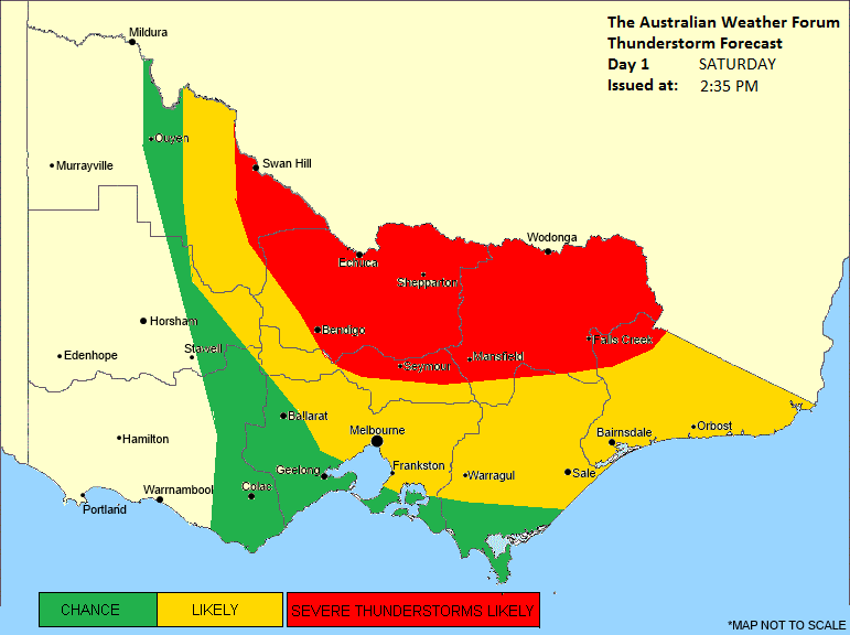
Here's our thunderstorm forecast for today, which you can also see on our website: http://theaustralianweatherforum.com/vi ... ecast.html

Thunderstorm Forecast - Day 1
Issued at 2:35pm Saturday 6th December 2014
Discussion for Saturday

Scattered thunderstorms developed early this morning over northern Victoria and moved into central parts of the state including Melbourng at around 5am. These storms were accompanied by heavy rainfall and even small hail, but have since cleared. For the remainder of today, a trough near northeast Victoria is likely to deepen, while an upper trough approaches from the west. These two troughs are resulting in a rather complex weather situation where thunderstorms are generally developing outside of expected areas. After analysis this morning, it's likely that instability will remain through central and eastern districts this afternoon and tonight, resulting in isolated and scattered thunderstorm activity. Thunderstorm activity is more likely through the Northeast, North Central and Northern Country districts during the afternoon where severe development may occur. Flash flooding and large hailstones would be the biggest risk, however damaging winds are also possible. Development is also likely through parts of the Gippsland, Central, Mallee and Wimmera districts, particularly as thunderstorms extend into these areas. At this stage, there is a nil risk for western parts. It is also worth to mention that supercell thunderstorms are possible this afternoon, especially in the "severe thunderstorms likely" area that has been marked on the chart. Recent guidance suggests that activity should persist into the evening. Thunderstorms have already redeveloped this afternoon over much of the northern parts of the state, and Bureau of Meteorology warnings are current, as well as Australian Weather Forum advices.
Image
Jake - Senior AWF Forecaster
Feel free to send me a private message if you have any questions.
d
droughtbreaker
Supercell
Reactions:
Posts: 2844
Joined: Wed Nov 25, 2009 7:50 pm
Location: Mount Macedon, VIC, 520m asl

Re: Stormy Period - Nov 29th - Dec 9th 2014

Post by droughtbreaker »

Echuca looks to be in the firing line. Supercells firing up in the area, looking extremely volatile and about to turn NW with the circulation towards the central northern Murray regions.
J
James
Supercell
Reactions:
Posts: 1059
Joined: Wed Nov 25, 2009 6:10 pm
Location: Boronia

Re: Stormy Period - Nov 29th - Dec 9th 2014

Post by James »

Well about 5am i was awoken by distant rumbles and poked my head out the door in the hope of seeing some lightning - saw a flash but it seemed far away...except the thunder was almost instantaneous and very crackly, scared the pants off me, but that was pretty much the only close one, the rest were all very distant

Not a lot of rain with it just heavy spitty drops for the most part.

Would be interesting to see if we get any more seems most other places have done well except for here, least we had a few rumbles but so far none could be called severe, just random isolated storms that appear then go just as quickly.
J
Jake Smethurst
Supercell
Reactions:
Posts: 3583
Joined: Mon Nov 23, 2009 8:49 pm
Location: Cheltenham

Re: Stormy Period - Nov 29th - Dec 9th 2014

Post by Jake Smethurst »

Some amazing cells over northern parts at the moment! :D
James » Sat Dec 06, 2014 3:03 pm wrote:
James wrote:Would be interesting to see if we get any more seems most other places have done well except for here, least we had a few rumbles but so far none could be called severe, just random isolated storms that appear then go just as quickly.
Still the chance of storms in Melbourne later today, but honestly the risk is diminishing slowly. Some showers/rain should wrap around though later or tomorrow. :)

The Australian Weather Forum
SEVERE THUNDERSTORM ADVICE - UPDATED
Please use Bureau of Meteorology warnings for official purposes

Thunderstorms continue to affect much of northern and eastern Victoria. A new severe cell has been identified on weather radar to the east of KYABRAM, and is likely to contain large hailstones, damaging winds and flash flooding. This cell will affect KYABRAM, ROCHESTER, ELMORE, ECHUCA and SURROUNDING AREAS during the next hour or so.

Please also note, Wangaratta in Victoria has received 51mm of rain in just 40 minutes from a thunderstorm a short time ago.
Jake - Senior AWF Forecaster
Feel free to send me a private message if you have any questions.
User avatar
Supercellimpact
Supercell
Reactions:
Posts: 1237
Joined: Thu Oct 07, 2010 8:39 pm
Location: Bendigo

Re: Stormy Period - Nov 29th - Dec 9th 2014

Post by Supercellimpact »

Looks like i'm about to get hammered here !
S
Spargs
Stratus
Reactions:
Posts: 16
Joined: Thu Nov 26, 2009 6:10 am
Location: Echuca

Re: Stormy Period - Nov 29th - Dec 9th 2014

Post by Spargs »

Nothing here in Echuca yet. Lots of high based clouds. Can definitely see the dark cell SE towards Kyabram.
S
Spargs
Stratus
Reactions:
Posts: 16
Joined: Thu Nov 26, 2009 6:10 am
Location: Echuca

Re: Stormy Period - Nov 29th - Dec 9th 2014

Post by Spargs »

It is now "persisting" down. Lots of thunder. .. no lightening as of yet...
Locked