A few rumbles around here for the last hour big surprise. Only 0.6mm's of rain though.
radar showing some small cells moving in from the bay.
Might be an interesting day.

Welcome New Members! We want to hear from you. Register, stop lurking and start posting!
Extended warm spell and becoming humid - Feb 6 to 24
Re: Extended warm spell and becoming humid - Feb 6 to 15
Stormed here overnight, lightning and all, wasn't something I expected, didn't last long and not very large falls, cloud is still looking very stormy to the east. Considering how humid/warm it was last night for this time of year (anyone else notice it as well?) I would not be surprised if the whole lot redevelops again quite quickly today.
- Rhino
- Supercell
- Reactions:
- Posts: 1227
- Joined: Mon Nov 30, 2009 11:37 am
- Location: Carisbrook-Near Maryborough
Re: Extended warm spell and becoming humid - Feb 6 to 15
Got woken by thunder around 6.30 and a couple of large drops so lets hope the day delivers  .
.
Rhino.
Rhino.
- Macedonian
- Supercell
- Reactions:
- Posts: 2330
- Joined: Mon Dec 21, 2009 10:44 pm
- Location: Mount Macedon Vic at 870m above sea level
Re: Extended warm spell and becoming humid - Feb 6 to 15
Thunder from 4am, a fair bit of lightning and the power went out a few times. Nice shower to wake up to and 2mm in the gauge 

4 or 5 days water into the tanks.
4 or 5 days water into the tanks.
Home- "Shepherd's Bush" at Mt Macedon. 870m
Work- "Bolobek" at Macedon. 430m
Work- "Bolobek" at Macedon. 430m
-
Tempest
- Cumulonimbus
- Reactions:
- Posts: 148
- Joined: Sat Aug 14, 2010 8:34 pm
- Location: Warragul North, Vic... 140m asl
Re: Extended warm spell and becoming humid - Feb 6 to 15
Woke up to rumbling this morning and even a short burst of large drops. Still some thunder hanging around. Eerie pinkish grey looking sky to the east. Hopefully all signs of an interesting day to come 
Re: Extended warm spell and becoming humid - Feb 6 to 15
and some large drops start falling again, believe it or not there was sun 5 minutes ago .. lol, still is sunny now .. heh.
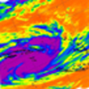
From looking at the radar is seems like its developing backward, see now over Geelong, spot over otways, probably keep on going then that will move towards Melbourne.
Just looked to the south west, that's one massive tower rising up out there, between anglesea and torquay is going to get slammed.
From looking at the radar is seems like its developing backward, see now over Geelong, spot over otways, probably keep on going then that will move towards Melbourne.
Just looked to the south west, that's one massive tower rising up out there, between anglesea and torquay is going to get slammed.
-
Tempest
- Cumulonimbus
- Reactions:
- Posts: 148
- Joined: Sat Aug 14, 2010 8:34 pm
- Location: Warragul North, Vic... 140m asl
Re: Extended warm spell and becoming humid - Feb 6 to 15
Yeah looks massive on radar too!tre75 » Thu Feb 14, 2013 6:48 am wrote:tre75 wrote:
Just looked to the south west, that's one massive tower rising up out there, between anglesea and torquay is going to get slammed.
- Gordon
- Supercell
- Reactions:
- Posts: 2896
- Joined: Thu Jun 17, 2010 10:01 am
- Location: Near Gordon, Vic. 620 m asl
Re: Extended warm spell and becoming humid - Feb 6 to 15
3 mm from that apparently tiny cell that passed over as just now (between Ballarat & Ballan on the radar). A few more of those and we'll start to see respectable totals.
Re: Extended warm spell and becoming humid - Feb 6 to 15
Lightning strike right near house, not sure where, but street does not have power now. Good cell went over Bonbeach absolute 0820hrs. Close lightning and loud thunder.
Re: Extended warm spell and becoming humid - Feb 6 to 15
The good thing about today is the fact that the development is small and pulsy because the sunbreak that we had here in Geelong feed that development to my sw over the otways, when I first looked out that way there was flat grey cloud - ie. the backend of the storm line that went over and is now out to my east, after the sun hit things bubbled up quite quickly - within 5-10 minutes, considering the height of the cell that's an impressive growth speed, probably 1k/more per minute, would have been awesome to capture on a slow motion camera.
Still hearing rumbles, might even end up that my prediction for it hitting the coast turns out to be coming for us here in Geelong, should be an interesting day no doubt about that ... 'I love smell of storms in the morning'
edit: One thing that also interesting to note, as the temp has been climbing here, so has the dew point as well
edit again: sorry 'I'm excited!' .. heh, there is but a breath of wind, the radar registers 6km/h not even enough to move the leaves of tree's outside, that means although the cells are moving fast the actual surface wind is slow which may also indicate multiple levels of wind speeds at differing heights, and considering that a line of storms wind over then redeveloped, it may also possibly indicate that the instability itself (the low trough) is slow moving so redevelopment may happen multiple times today, awesome stuff.
Last edited by tre75 on Thu Feb 14, 2013 8:49 am, edited 1 time in total.
-
occluded

- Cumulonumbus Calvas
- Reactions:
- Posts: 611
- Joined: Tue May 04, 2010 3:26 pm
- Location: Mooroolbark 130m asl
Re: Extended warm spell and becoming humid - Feb 6 to 15
Nothing at home or the CBD yet, but when I stepped outside this morning at home you could 'smell' the storms brewing.
Nearly fell off my chair when I heard the forecast on TV (ABC) last night, no mention of any isolated storms at all and I believe 'a good evening for an alfresco Valentines Day dinner' was the quote from memory. Luckily I get my forecasts here first.
20.1/15.7 at home so DP certainly getting up there.
Edit: fixed typo (wrote post before coffee!)
Last edited by occluded on Thu Feb 14, 2013 9:37 am, edited 1 time in total.
- I_Love_Storms
- Supercell
- Reactions:
- Posts: 2812
- Joined: Wed Dec 02, 2009 2:01 pm
- Location: Hawthorn
Re: Extended warm spell and becoming humid - Feb 6 to 15
GFS didn't even have any instability forecast for this morning 

5pm looks much better

5pm looks much better
Re: Extended warm spell and becoming humid - Feb 6 to 15
Seems like its fizzling out here, still hearing thunder and I can see some smaller towers around, though the lack of sun has halted development, however to the west I see blue skies, your guess is as good as mine as to what happens then ... I gotta leave soon, I'll probably get into town and then either get drenched on the way in, or on the way back, or not at all, either way it good that the ground at least got some water, been so dry, plants will soak anything they can get at this point.
-
Tempest
- Cumulonimbus
- Reactions:
- Posts: 148
- Joined: Sat Aug 14, 2010 8:34 pm
- Location: Warragul North, Vic... 140m asl
Re: Extended warm spell and becoming humid - Feb 6 to 15
Anyone know what this is called? It was directly overhead on the edge of a cloud about an hour ago.

We've had a good short soaking here this morning with thunder on and off since around 6.30am. Some nice mammatus passed by earlier too. Hoping for a few more surprises throughout the day
We've had a good short soaking here this morning with thunder on and off since around 6.30am. Some nice mammatus passed by earlier too. Hoping for a few more surprises throughout the day
-
Rivergirl

- Memorial
- Reactions:
- Posts: 3674
- Joined: Sun Nov 22, 2009 6:04 pm
- Location: Ferny Creek VIC
- Contact:
Re: Extended warm spell and becoming humid - Feb 6 to 15
Yes was nice to get the thunderstorm and rain over Ferny Creek but it happened just after the painters had set everything up to paint the decks today. They pulled the plug.
Thats beautiful Tempest. I googled this
Thats beautiful Tempest. I googled this
They're givien the coloquial name of "fire rainbows" and they are due high, wispy clouds that are made of tiny ice crystals, and if the cloud is at the right angle to the sun, the crystals will refract the sunlight (much like a prism) into the colors of the rainbow.
So it's very similar to a regular rainbow-when-it's-raining, only a little more rare.
These fire rainbows are rare sights in the mid-latitudes, because they can only occur when the sun is 58 degrees or higher above the horizon. For the United States in general that pretty much relegates any sightings to roughly around 6 weeks either side of the summer solstice.
- Dane
- Supercell
- Reactions:
- Posts: 1661
- Joined: Thu Nov 26, 2009 9:51 am
- Location: Sebastopol 420m ASL
- Contact:
Re: Extended warm spell and becoming humid - Feb 6 to 15
just 0.8mm's here this morning, with plenty of rumbles.
Was up at Berwick at 8.45am for an eye specialist appointment.
It was pouring there at 9am with loud booming thunder.
I notice that Hampton Park got 23mm's up to 9am - so some good totals if you get right under one of these.
Hopefully we will get some more later.
Was up at Berwick at 8.45am for an eye specialist appointment.
It was pouring there at 9am with loud booming thunder.
I notice that Hampton Park got 23mm's up to 9am - so some good totals if you get right under one of these.
Hopefully we will get some more later.
- Rhino
- Supercell
- Reactions:
- Posts: 1227
- Joined: Mon Nov 30, 2009 11:37 am
- Location: Carisbrook-Near Maryborough
Re: Extended warm spell and becoming humid - Feb 6 to 15
Birchip got 43mm out of those storms last night, someone rang in on radio this morning, arvo looking good for those that get under a storm and more  for those that don't.
Rhino.
Rhino.
Re: Extended warm spell and becoming humid - Feb 6 to 15
Definitely heating up now slight SE wind which seems to be building in intensity, not sure if there really is any trigger for storms this afternoon seems to be standard high jet-stream cirrus (with a more stratus like formation, as in it covers the whole sky out westwards uniformly), I guess time will tell, give it a few more hours.
-
Australis(Shell3155)

- Supercell
- Reactions:
- Posts: 3147
- Joined: Mon Nov 30, 2009 8:05 pm
- Location: FTG
- Contact:
Re: Extended warm spell and becoming humid - Feb 6 to 15
http://www.atoptics.co.uk/fz830.htm" onclick="window.open(this.href);return false;Tempest » Thu Feb 14, 2013 9:25 am wrote:Tempest wrote:Anyone know what this is called? It was directly overhead on the edge of a cloud about an hour ago.
http://www.atoptics.co.uk/" onclick="window.open(this.href);return false; great site to waste some time on..
Re: Extended warm spell and becoming humid - Feb 6 to 15
There was some good thunder to the south this morning! - deep booming even though a fair distance off.
Sun is out now ....waiting to see what else we can score later today?
Sun is out now ....waiting to see what else we can score later today?