Good pick up John, and it highlights a problem with the models.
How can we pick these things up months beforehand? Simple, because models are told that El nino is king, Co2 is warming the oceans etc etc.
Yet we look at these things and can see we are in a cold PDO, most models would not have any clue about the 1950s and what a cold PDO means to the global climate.
I based my forecast on the fact the highs would sink south about now and allow the pattern shift, and that shift was made possible because the SPCZ was continually pounding PNG all winter.
And then, once that occurs, warming of the IOD has to follow from the Throughflow because upper 300M heat content has been high all winter and the surface has been cool.
Somehow this logical piece of thinking escapes climatologists who have agendas and cant see past their nose, you would think the PAcific is on fire the rubbish you read around the traps.
Also, if you follow Tisdale you will know that warming from the El nino in any years linger on for many years afterwards, although its only for strong ones. But my theory is that after a weak warming like this, which peaked early June, it moves to the Indian 3-6 months later.
Just a theory and i need to work on the correlations more.
In any case, what we have seen is the atmosphere drive the oceans, rather than the oceans driving the atmosphere.

Welcome New Members! We want to hear from you. Register, stop lurking and start posting!
AWF Climate Outlook - Spring 2012
-
Anthony Violi

- Supercell
- Reactions:
- Posts: 2652
- Joined: Mon Nov 23, 2009 9:03 pm
- Location: Lilydale
- Contact:
Re: AWF Climate Outlook - Spring 2012
http://www.therealworldweatherforum.com" onclick="window.open(this.href);return false;
avweatherforecasts.com
avweatherforecasts.com
Re: AWF Climate Outlook - Spring 2012
Yeah AV I agree we are in a cold PDO phase..

Go the bombersss!
Re: AWF Climate Outlook - Spring 2012
Previous 3 El Ninos compareing the Ssts anomalies for this time of the Year with this half hearted attempt of an El Nino
2002 September 22nd: http://weather.unisys.com/archive/sst/s ... 020922.gif" onclick="window.open(this.href);return false;
2006 September 24th: http://weather.unisys.com/archive/sst/s ... 060924.gif" onclick="window.open(this.href);return false;
2009 September 20th: http://weather.unisys.com/archive/sst/s ... 090920.gif" onclick="window.open(this.href);return false;
2012 September 20th: http://weather.unisys.com/surface/sst_anom.gif" onclick="window.open(this.href);return false;
-
Anthony Violi
- Supercell
- Reactions:
- Posts: 2652
- Joined: Mon Nov 23, 2009 9:03 pm
- Location: Lilydale
- Contact:
Re: AWF Climate Outlook - Spring 2012
By November the basin will be more cool than warm...and the Indian will be warm, as will the Coral Sea.
Just trying to find a calculator to see if i can work out what the answer is.
Just trying to find a calculator to see if i can work out what the answer is.
http://www.therealworldweatherforum.com" onclick="window.open(this.href);return false;
avweatherforecasts.com
avweatherforecasts.com
-
crikey

- Supercell
- Reactions:
- Posts: 1314
- Joined: Mon Feb 07, 2011 8:02 pm
- Location: tweed shire NSW and nDUNOLLY.. Nth Central district VIC
- Contact:
Re: AWF Climate Outlook - Spring 2012
Following along and enjoying the read. Love the enthusiasm and always interesting to hear how others see the situation.
I like you maps in explaining your theories AV . For one who never really follows the ocean stuff l am finding that info enlightening.
Thanks'guys'
I am not sure that the ENSO stage will change mid stream in the cycle so somehow l still like an El Nino with pos IOD to see us through this ENSO cycle . The SOI peaking in summer as it usually does.
but l will keep an open mind as l follow along here re: the SST's
-
Anthony Violi
- Supercell
- Reactions:
- Posts: 2652
- Joined: Mon Nov 23, 2009 9:03 pm
- Location: Lilydale
- Contact:
Re: AWF Climate Outlook - Spring 2012
No worries Crikey. If you want a forecast for the ENSO, IOD and SST, just go opposite to the models and thats going to be a closer outcome.
Im not sure if you have noticed bu the +IOD was brief and seasonal, but its now over and temps have exploded rapidly at the surface through the region, as i suggested would occur three months ago.
Also notice all the models are miles behind and only now are starting to come to grips with the cold PDO not allowing El ninos to develop. In a cold PDO the warm spike is simply a response to the strong La nina's.
And now you can see the heat is almost gone, Nino 3.4 index has plunged last 7 days and SOI had a daily reading yesterday of 21. By the end of October the 90 day will be positive and everyone will be scratching thier heads wondering what has happened.
Have a look at CFS, its miles behind the game, only now starting to wake up and relaise it wont be an El Nino, its just a neutral year.

Watch in the next month as the blue lines pile on South, and the black average line ends up in the negatives.
And heres why, its so obvious. The de-coupling initself was enough to forecast a neutral in my mind, but this confirms it.
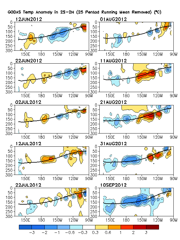
There is just no heat in the pipeline. This has been the case for months. And all the models see are the warm spots in the subsurface, and they think that somehow greenhouse gases get into the oceans and warm them up, FFS give me a spell.
Look at the PDO chart, 70% or more dominated by La nina's, and response to El Nino is weak and short lived.
Thats the horse you need to be backing Crikey, the warm/cold has flipped already and in 6 weeks everyone will think they are in the twilight zone, including the BOm and any one else who uses models to forecast.
Im not sure if you have noticed bu the +IOD was brief and seasonal, but its now over and temps have exploded rapidly at the surface through the region, as i suggested would occur three months ago.
Also notice all the models are miles behind and only now are starting to come to grips with the cold PDO not allowing El ninos to develop. In a cold PDO the warm spike is simply a response to the strong La nina's.
And now you can see the heat is almost gone, Nino 3.4 index has plunged last 7 days and SOI had a daily reading yesterday of 21. By the end of October the 90 day will be positive and everyone will be scratching thier heads wondering what has happened.
Have a look at CFS, its miles behind the game, only now starting to wake up and relaise it wont be an El Nino, its just a neutral year.
Watch in the next month as the blue lines pile on South, and the black average line ends up in the negatives.
And heres why, its so obvious. The de-coupling initself was enough to forecast a neutral in my mind, but this confirms it.
There is just no heat in the pipeline. This has been the case for months. And all the models see are the warm spots in the subsurface, and they think that somehow greenhouse gases get into the oceans and warm them up, FFS give me a spell.
Look at the PDO chart, 70% or more dominated by La nina's, and response to El Nino is weak and short lived.
Thats the horse you need to be backing Crikey, the warm/cold has flipped already and in 6 weeks everyone will think they are in the twilight zone, including the BOm and any one else who uses models to forecast.
http://www.therealworldweatherforum.com" onclick="window.open(this.href);return false;
avweatherforecasts.com
avweatherforecasts.com
-
stratospear

- Supercell
- Reactions:
- Posts: 1261
- Joined: Sat Dec 19, 2009 9:38 am
- Location: Usually Bendigo
Re: AWF Climate Outlook - Spring 2012
Not sure if this will have much impact on our Spring weather (perhaps just strengthen cold fronts in the coming months and chill the Southern Ocean a bit) with record Antarctic Sea Ice:
http://www.scoop.co.nz/stories/SC1209/S ... d-high.htm" onclick="window.open(this.href);return false;
http://arctic.atmos.uiuc.edu/cryosphere ... arctic.png" onclick="window.open(this.href);return false;
http://arctic.atmos.uiuc.edu/cryosphere ... arctic.png" onclick="window.open(this.href);return false;
- I_Love_Storms
- Supercell
- Reactions:
- Posts: 2812
- Joined: Wed Dec 02, 2009 2:01 pm
- Location: Hawthorn
Re: AWF Climate Outlook - Spring 2012

No El Nino by the looks. Neutral looks most likely...
-
Anthony Violi
- Supercell
- Reactions:
- Posts: 2652
- Joined: Mon Nov 23, 2009 9:03 pm
- Location: Lilydale
- Contact:
Re: AWF Climate Outlook - Spring 2012
My new seasonal forecast is out.
http://anthonyvioli.wordpress.com/2012/ ... mber-2012/" onclick="window.open(this.href);return false;
http://anthonyvioli.wordpress.com/2012/ ... mber-2012/" onclick="window.open(this.href);return false;
http://www.therealworldweatherforum.com" onclick="window.open(this.href);return false;
avweatherforecasts.com
avweatherforecasts.com
- Petethemoskeet
- Cumulonimbus
- Reactions:
- Posts: 272
- Joined: Mon Mar 08, 2010 1:06 pm
- Location: Toowoomba
Re: AWF Climate Outlook - Spring 2012
Looking at the satellite pics over the last few days there is a lot of moisture starting to stream in from the warming Indian Ocean.This bodes well for the rest of spring and summer for some good rain.IMO flooding could become an issue later in the year especially if La Nina takes a good hold.
-
occluded

- Cumulonumbus Calvas
- Reactions:
- Posts: 611
- Joined: Tue May 04, 2010 3:26 pm
- Location: Mooroolbark 130m asl
Re: AWF Climate Outlook - Spring 2012
First post in Climatology so here goes:
http://www.theage.com.au/environment/cl ... 26wfp.html
Here's some selected extracts from the article:
And here's a good one:

http://www.theage.com.au/environment/cl ... 26wfp.html
Here's some selected extracts from the article:
Still sticking to the El-Nino prediction it seems. I'll be keenly waiting for the retraction from the BoM in the event we get smashed again during late Spring and Summer for the third year in a row.Much of the country's south-east recorded another below-average rainfall result for the key April to September period, and the Bureau of Meteorology is tipping warmer and drier-than-normal weather for the rest of 2012.
Now I havent dug through all the records but I thought that SA had got plenty of rainfall this winter?Across southern Australia, September's rainfall came in at 15.6 millimetres – more than 40 per cent below the 1961 to 1990 average, said Karl Braganza, manager of climate monitoring for the Bureau of Meteorology. Nationally, the previous month was even drier – the sixth-driest August in 110 years of records.
"It really was dry through most of South Australia into western NSW, much of Victoria and large parts of WA," Dr Braganza said, referring to the six-month stretch.
"It's a pattern of drying that we have now observed for more than 15 years over in the east, and for more than 30 years out in the west.
Here's my favourite:The last very wet winter - with rainfall greater than 50 per cent above the seasonal averager (sic) - in the nation's south-east was 1991, while south-western WA hasn't had one since 1965.
Yes, it's all because of man-made actions, that's "proven" right?Scientists say Australian winters are becoming drier with man-made actions - particularly the burning of fossil fuels - to blame.
And here's a good one:
All hail the climate models...Penny Whetton, a senior principal research scientist developing climate change projections at the CSIRO, said modelling of the climate's response to increased greenhouse gases in the atmosphere points to the drying in the cool seasons across Australia.
-
crikey
- Supercell
- Reactions:
- Posts: 1314
- Joined: Mon Feb 07, 2011 8:02 pm
- Location: tweed shire NSW and nDUNOLLY.. Nth Central district VIC
- Contact:
Re: AWF Climate Outlook - Spring 2012
Great your posting in climate occluded!!
The research paper from that news article is here
( just cut and past this title and link below into Google and the pdf link will come up)
Climate and water availability in south-eastern Australia
http://www.seaci.org/publications/.../S ... Report.pdf" onclick="window.open(this.href);return false;
The models indicate the current rainfall patterns have been related to changes in C02 increase, stratospheric ozone decline .
They show that the Hadley cell is expanding at some 50km a decade .and the SAM has been tending more positive causing the storm tracks to shift further south.
They say that this can only be replicated by inputting the C02 emissions and other pollutants.
However l do wonder if the changes to stratospheric ozone could be more related to the solar energy input .
If the models are correct then we can be assured of a decline in rainfall mainly during Autumn/winter l believe. south of 33 deg latitude
The models all agree on the decreasing rainfall Autumn/ winter l gather but are not so committed regarding the percentage decline.
I am only partly way through the report as it its some 47 pages long phew!
I hope they are wrong because n/west vic is dry anyway and to be dryer is a very bad thing!!
cheers
Re: AWF Climate Outlook - Spring 2012
johnno » Thu Aug 30, 2012 4:18 pm wrote:johnno wrote:Yes the IO will improve but wont be til the end of Spring. Lets go by your theory anyway that the ssts in the IO make a drastic improvement the next few weeks anyway we know it takes the atmosphere another 3-4 weeks to respond to the ocean temps I can preety much guarantee September will see below average rainfall through alot of Australia away from the Victorian coast and October won't be much different anyway thats my 2c had this theory for 2 months now and August has seem to gone on the dry side & I don't mean "seasonal dry" I mean below average rainfall for alot of OZ away from Southern Victoria and I expect this trend to continue for at least another 2 months.. We know its drier in Brisbane and Sydney this time of the Year but they still average close to the same rainfall as Melbourne 50mm or so and both Cities have fallen way short of that this month infact Brisbane has had no rain which to me shows the lack of moisture with the systems that have come through this month from the NW and the Coral sea this is indicative of a Positive IOD coincinding with a weak El Nino or warm Neutral conditions.
I wrote that on the 30th of August neally 2 months ago now and I think this is preety much exactly how its panned out. The rainfall will come back but won't be til November and even then I still think it will be slightly below average for alot of Eastern and SE inland areas of Australia but better than it has been (away from the Victorian coast especially West Gippsland and parts of Eastern suburbs of Melbourne). Better rainfall & storms will start happening in Summer.
Re: AWF Climate Outlook - Spring 2012
By the way Karl & Jake I will do the 3 months seasonal forecast for November to January pronto for you guys by this coming Weekend! Thats a Promise 
Re: AWF Climate Outlook - Spring 2012
Latest BOM ENSO wrap up
Pacific’s late retreat to neutral considered unusual
Issued on Tuesday 23 October | Product Code IDCKGEWWOO
Indicators of the El Niño Southern Oscillation (ENSO) continue to show neutral values. Temperatures in the tropical Pacific Ocean generally remain near average, after being close to El Niño thresholds in late winter. Atmospheric indicators such as the Southern Oscillation Index (SOI) and tropical cloud patterns have persisted at neutral levels through much of the southern winter and spring.
The retreat from El Niño thresholds over the past several weeks is considered highly unusual, as September–October is typically the time when developing El Niño (or La Niña) events consolidate and mature. While some chance of El Niño remains, climate models surveyed by the Bureau of Meteorology suggest sea surface temperatures in the tropical Pacific Ocean are likely to be warmer than average, but stay within the neutral range for the rest of 2012 and early 2013.
This year has seen a positive Indian Ocean Dipole (IOD) event, which partly explains the unusually dry conditions experienced over much of Australia in recent months. Outlooks from the Bureau’s climate model indicate the IOD is likely to return to neutral values over the next month. A positive IOD is typically associated with decreased winter and spring rainfall over parts of southern, central and northern Australia, but declines in both value and influence with the onset of the Australian monsoon at the start of summer.
- Jake Smethurst
- Supercell
- Reactions:
- Posts: 3583
- Joined: Mon Nov 23, 2009 8:49 pm
- Location: Cheltenham
Re: AWF Climate Outlook - Spring 2012
Thanks John 
Jake - Senior AWF Forecaster
Feel free to send me a private message if you have any questions.
Feel free to send me a private message if you have any questions.
- flyfisher
- Cumulonimbus
- Reactions:
- Posts: 250
- Joined: Wed Jul 18, 2012 1:39 pm
- Location: Belgrave
- Contact:
Re: AWF Climate Outlook - Spring 2012
The ocean temp charts continue to show warming in the Australian region. Although the coral sea is subbornly holding out. Seems that tongues of cool water keep getting swepted into the central coral sea and even along the coast. Temps are slightly cooler than average here. I keep egging on that huge mass of warm water to the NE of the coral sea to move into our region and help pump moisture into central Australia. The gulf is a little cooler too, must be those southerly surges and strong SE winds.
Indian Ocean, lots of warm water NW of Australia and along the coast. A big cold pool in the central Indian ocean at the moment. Winds are starting to turn westerly up there near the equator which should help push that IOD back more negative. The NW is looking good.
Weather wise, the atmosphere has not really responded to the warmer waters around Australia - yet. Uppers in southern Australia have not been that favorable either. So it's not all coming together at the moment, hence the dry October. Would really like the coral sea to warm up so we can get surface moisture levels much higher than they are currently. Indian ocean won't do that much for us now, of course it can throw an ex cyclone or two our way, I won't complain.
-
Karl Lijnders

- Tornadic Supercell
- Reactions:
- Posts: 5771
- Joined: Sun Nov 22, 2009 11:17 pm
- Location: Knoxfield, Victoria
Re: AWF Climate Outlook - Spring 2012
Certainly taking it's time to our NE in the Coral but should recover through the wet season. Cyclone season may be enhanced in and around Darwin and down the WA coast too this year so something to watch for us here in the SE as FF has stated.
Other than that, it is looking like a wetter start to 2013 IMO with the IOD back in favor.
Other than that, it is looking like a wetter start to 2013 IMO with the IOD back in favor.
Former Owner - The Australian Weather Forum. Email me anytime - weatherman1000@hotmail.com
- droughtbreaker
- Supercell
- Reactions:
- Posts: 2844
- Joined: Wed Nov 25, 2009 7:50 pm
- Location: Mount Macedon, VIC, 520m asl
Re: AWF Climate Outlook - Spring 2012
That's the problem at the moment. The +ve IOD caused September and October to be dry. As we know, the IOD breaks down in late spring and the Pacific and northern AUS waters become more important for our rainfall down here in the SE. The conditions in the Pacific have been warm neutral for the last several months and got close to El Nino thresholds. Things are starting to recover in this regard but it will take the atmosphere some time to respond and perhaps the storm outbreak over SE QLD is the first sign of this happening.
Hopefully December can see the return of decent rainfall for us.
Hopefully December can see the return of decent rainfall for us.
- flyfisher
- Cumulonimbus
- Reactions:
- Posts: 250
- Joined: Wed Jul 18, 2012 1:39 pm
- Location: Belgrave
- Contact:
Re: AWF Climate Outlook - Spring 2012
Sea surface temperature are still looking good.
NW Australia has some of the warmest waters in the world right now - it's only a matter of time before the monsoon trough reacts to this.
Coral sea has improve a bit to slightly warm to neutral conditions. Certainly there is a lot more moisture being pumped into Australia now. Unfortunately we are not getting good upper support to make something of it in SE Australia. E.g. the system just through had heaps of humidity but no real support to make something of it. Further analysis of the SAM may make some sense of why this is the case.
The pacific waters do have the pre La Nina feel about them. Water next to South America is cooler as is the sub surface. The next ENSO update will be interesting. We could be looking at a La Nina just in time for the Australian winter.