Looks like a long warm to hot and mostly dry sequence head. Shots of fairly hot air, though fortunately we escape the record heat that sits over WA. Looks like it will cap off a very dry and hot month for most of us.
Not really seeing much rain. Odd shower for eastern areas initially, then the odd shower near the front late this week, but overall not much in it.

Welcome New Members! We want to hear from you. Register, stop lurking and start posting!
Warm to hot with mostly dry changes. February 20-28
Forum rules
When posting photos, particularly in active breaking weather threads, please link to clickable photos to minimise download issues. For more information, see Posting Photo Guidelines for more information. Threads that are six weeks old or older will be Archived Here
When posting photos, particularly in active breaking weather threads, please link to clickable photos to minimise download issues. For more information, see Posting Photo Guidelines for more information. Threads that are six weeks old or older will be Archived Here
-
hillybilly

- Site Admin/Moderator
- Reactions:
- Posts: 4986
- Joined: Thu Nov 26, 2009 7:26 am
- Location: Howden Tasmania, 25m above sea level
- Contact:
-
hillybilly
- Site Admin/Moderator
- Reactions:
- Posts: 4986
- Joined: Thu Nov 26, 2009 7:26 am
- Location: Howden Tasmania, 25m above sea level
- Contact:
Warm to hot with mostly dry changes. February 20-28
Warm one today. Chance of showers for eastern VIC, and maybe the odd rumble. Quite widespread but hit and miss showers and maybe the odd rumble for TAS. Not a lot in it, but anything is welcome.
- StratoBendigo
- Supercell
- Reactions:
- Posts: 2809
- Joined: Fri Jan 02, 2015 2:18 pm
- Location: Kangaroo Flat
Warm to hot with mostly dry changes. February 20-28
Where did that come from? Just got 14mm. A few flangs in the mix too.
Warm to hot with mostly dry changes. February 20-28
Yes agree, thunderstorms and 5mls,so far, no warning, pleasant surprise.StratoBendigo wrote: ↑Tue Feb 20, 2024 7:22 pm Where did that come from? Just got 14mm. A few flangs in the mix too.
-
93ben
- Site Admin
- Reactions:
- Posts: 603
- Joined: Tue Dec 27, 2011 12:28 am
- Location: Templestowe, Victoria
- Contact:

Warm to hot with mostly dry changes. February 20-28
Those storms are crazy over croydon/ringwood. Had to drive through it with 1cm sized hail and torrential rain.

Warm to hot with mostly dry changes. February 20-28
After building up for the last few hours, those outer east suburbs cells have made it to us too.
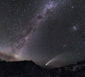
Here’s the last pic I took before I started getting wet. Good light show too
Here’s the last pic I took before I started getting wet. Good light show too

- Attachments
-
- IMG_1496.jpeg (2.03 MiB) Viewed 972 times
-
hillybilly
- Site Admin/Moderator
- Reactions:
- Posts: 4986
- Joined: Thu Nov 26, 2009 7:26 am
- Location: Howden Tasmania, 25m above sea level
- Contact:
Warm to hot with mostly dry changes. February 20-28
Good to see some get lucky yesterday. Down here mid level rubbish killed the convection just after noon. Heavy falls for the northeast corner of TAS. Those storms for Victoria were remarkable. Pulse storms with slow movement so hit and miss. Odd spot around 40mm but neighbouring suburbs seeing zero.
Now comes the heat with mid to high 30s for Victoria the next two days. Will get into the low 40s in the northwest. Bit of humidity but uppers are hot so be suprised to see anything other than very isolated activity from middle of today. TAS is a few degrees cooler. Quite windy so with things crispy makes for a bit of a nervous time for those in the bush.
Front is late on Thursday into Friday and will have a few stream showers, but not much in it for most.
-
Mosaic
- Cumulus
- Reactions:
- Posts: 90
- Joined: Mon Nov 30, 2009 2:39 pm
- Location: Glen Waverley, Victoria
Warm to hot with mostly dry changes. February 20-28
We got smased at Warranwood by those cells yesterday. Got a heap of hail and probably 20mm of rain.
- Attachments
-
- IMG_0199.JPG (170.91 KiB) Viewed 875 times
- Tassiedave
- Supercell
- Reactions:
- Posts: 1098
- Joined: Thu Nov 11, 2010 11:09 am
- Location: Grindelwald Tasmania
Warm to hot with mostly dry changes. February 20-28
In the last 90 minutes (to 1.30pm) St Helens (NE Tas) has had 60mm of rain. Since 7.30pm last night St Helens 146mm. Incredible!
- Skywalker
- Supercell
- Reactions:
- Posts: 1871
- Joined: Sun Nov 29, 2009 10:03 am
- Location: Burnside Heights/Cowes (Home) & Sunshine West (Work)
Warm to hot with mostly dry changes. February 20-28
It's really bizarre seeing that on the radar.Tassiedave wrote: ↑Wed Feb 21, 2024 1:29 pm In the last 90 minutes (to 1.30pm) St Helens (NE Tas) has had 60mm of rain. Since 7.30pm last night St Helens 146mm. Incredible!
Unbelievable!
Caroline Springs, Melbourne's meteorological boredom zone.
-
hillybilly
- Site Admin/Moderator
- Reactions:
- Posts: 4986
- Joined: Thu Nov 26, 2009 7:26 am
- Location: Howden Tasmania, 25m above sea level
- Contact:
Warm to hot with mostly dry changes. February 20-28
Hot one yesterday here with 29C. Expect about 34C here today which will be the high point for summer. Horribly dry here now. Hobart is currently running driest February on record, while weve had 8mm so not as bad but still grim.
Late change for all of us. Looks like 7pm give or take for Melbourne and Hobart. Quite slow moving. Looks dry for the majors but always the chance of something high based.
Thinking peak temps for vic will be around 43C, and around 36C for TAS. Wind will make it nervous for those in the bush.
Late change for all of us. Looks like 7pm give or take for Melbourne and Hobart. Quite slow moving. Looks dry for the majors but always the chance of something high based.
Thinking peak temps for vic will be around 43C, and around 36C for TAS. Wind will make it nervous for those in the bush.
- Skywalker
- Supercell
- Reactions:
- Posts: 1871
- Joined: Sun Nov 29, 2009 10:03 am
- Location: Burnside Heights/Cowes (Home) & Sunshine West (Work)
Warm to hot with mostly dry changes. February 20-28
Horrible conditions coming up here today in Melbourne's uneventful western desert. 
Potentially 40 degrees along with the disgusting windy filth which is already here.

Potentially 40 degrees along with the disgusting windy filth which is already here.
Caroline Springs, Melbourne's meteorological boredom zone.
- StratoBendigo
- Supercell
- Reactions:
- Posts: 2809
- Joined: Fri Jan 02, 2015 2:18 pm
- Location: Kangaroo Flat
Warm to hot with mostly dry changes. February 20-28
Things are spiralling out-of-control between Ararat and Beaufort with a large bushfire bearing down on Mt Cole and nearby towns.
Very very dangerous, so stay well away from that region...
Very very dangerous, so stay well away from that region...
- Gordon
- Supercell
- Reactions:
- Posts: 2889
- Joined: Thu Jun 17, 2010 10:01 am
- Location: Near Gordon, Vic. 620 m asl
Warm to hot with mostly dry changes. February 20-28
Smoke cloud on the radar growing rapidly .  Smoke-filled sky here now.
Smoke-filled sky here now.- Gordon
- Supercell
- Reactions:
- Posts: 2889
- Joined: Thu Jun 17, 2010 10:01 am
- Location: Near Gordon, Vic. 620 m asl
Warm to hot with mostly dry changes. February 20-28
Base of the pyro cumulus cloud now extends right over our place, and we're at least 80km to the east of the fire.
- Macedonian
- Supercell
- Reactions:
- Posts: 2330
- Joined: Mon Dec 21, 2009 10:44 pm
- Location: Mount Macedon Vic at 870m above sea level
Warm to hot with mostly dry changes. February 20-28
It's just gone dark and smokey in the sky over Macedon.
Would not like to be out their near Beaufort/Ararat.
Can't wait for autumn next week.
Would not like to be out their near Beaufort/Ararat.
Can't wait for autumn next week.
Home- "Shepherd's Bush" at Mt Macedon. 870m
Work- "Bolobek" at Macedon. 430m
Work- "Bolobek" at Macedon. 430m
- stevco123
- Supercell
- Reactions:
- Posts: 2936
- Joined: Sat Aug 07, 2010 7:42 pm
- Location: Cranbourne 78m asl
Warm to hot with mostly dry changes. February 20-28
Did not expect the smoke to make it in outer south east Melbourne that quick, by then again I've forgotten how dynamic big fires are.
Red sky now, alternating with cloud
Red sky now, alternating with cloud
https://www.weatherlink.com/bulletin/53 ... 76dd68e8bc: for current weather updated every 2 minutes
-
Blackee

- Site Admin/Moderator
- Reactions:
- Posts: 3857
- Joined: Tue Nov 24, 2009 8:57 pm
- Location: Elwood and Mansfield 370m
Warm to hot with mostly dry changes. February 20-28
Torrential rain in Brighton out of nowhere. Radars presently offline
Mansfield 370m and Elwood
Warm to hot with mostly dry changes. February 20-28
Yes very concerning for all those towns, know that area very well.StratoBendigo wrote: ↑Thu Feb 22, 2024 2:28 pm Things are spiralling out-of-control between Ararat and Beaufort with a large bushfire bearing down on Mt Cole and nearby towns.
Very very dangerous, so stay well away from that region...
-
hillybilly
- Site Admin/Moderator
- Reactions:
- Posts: 4986
- Joined: Thu Nov 26, 2009 7:26 am
- Location: Howden Tasmania, 25m above sea level
- Contact:
Warm to hot with mostly dry changes. February 20-28
Utterly horrible day here. 36C, Smokey skies from a big fire in the upper Derwent Valley and gusty swirling winds. Starting to look a bit b grade disaster movie around here with every thing crisped right off now with almost no rain for a month.
Nasty back in VIC, though a lucky few got a storm. Some spot falls around 8mm.
That fire northwest of Melbourne looks terrible. Big run through rural areas. Amazed how quickly this summer has turned from floods and heat and fires.
Some showers tomorrow, mainly western Vic and eastern parts of Melbourne. Not much elsewhere.
EC suggesting next week might see a repeat of today. Hopefully that don’t happen