
Welcome New Members! We want to hear from you. Register, stop lurking and start posting!
Vic - Humid & Potential for Rain: Feb 5-20, 2020
Re: Vic - Humid & Potential for Rain: Feb 5-20, 2020
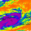
Looks like some more development happening to the west of here. It is so good seeing everything so green around town this time of year! Parks, nature strips and surrounding hills.
Last edited by Adam38 on Fri Feb 14, 2020 5:15 pm, edited 1 time in total.
-
hillybilly

- Site Admin/Moderator
- Reactions:
- Posts: 4980
- Joined: Thu Nov 26, 2009 7:26 am
- Location: Howden Tasmania, 25m above sea level
- Contact:
Re: Vic - Humid & Potential for Rain: Feb 5-20, 2020
Just passed 40mm. Wierd how it exploded on the convergence between the northeasterly and swly wind change, then collapsed into a broad rainband.
Locally there is a patch around Ringwood East to Bayswater which is showing a clustering of rainfall totals in the 60 to 90mm rain. One gauge is is showing 95mm. They were under the storm for longer than us - perhaps 20 minutes longers so doesn't surprise me It drops away quickly to my north with only ~10mm around Kalorama and less than 5mm around Monbulk. Some crazy gradients there...
MTD is about 90mm, YTD somewhere just south of 300mm. Awesome start to the year, and about 10 times wetter than this point last year
The main rainband for tonight is still out in west-central. Should be worth 10-20mm overnight into tomorrow.
Locally there is a patch around Ringwood East to Bayswater which is showing a clustering of rainfall totals in the 60 to 90mm rain. One gauge is is showing 95mm. They were under the storm for longer than us - perhaps 20 minutes longers so doesn't surprise me
MTD is about 90mm, YTD somewhere just south of 300mm. Awesome start to the year, and about 10 times wetter than this point last year
The main rainband for tonight is still out in west-central. Should be worth 10-20mm overnight into tomorrow.
- Tassiedave
- Supercell
- Reactions:
- Posts: 1098
- Joined: Thu Nov 11, 2010 11:09 am
- Location: Grindelwald Tasmania
Re: Vic - Humid & Potential for Rain: Feb 5-20, 2020
Tas temps today: Bushy Park 30.4, Campania 30.0, Strahan 28, Scottsdale 27.8, Launceston 27.1, Devonport 24.3, St Helens 23.3
- Sean
- Supercell
- Reactions:
- Posts: 1000
- Joined: Mon Feb 27, 2012 6:35 pm
- Location: Patterson Lakes - SE Melb
Re: Vic - Humid & Potential for Rain: Feb 5-20, 2020
The second band of what has been a two pronged system looks promising, but will it decay?
Don't want to be ungrateful but I'm pretty disappointed so far. I keep getting skirted. If you want good storms the bay is poison it seems, with the best storms happening over the western plains or further east away from the bay.
Don't want to be ungrateful but I'm pretty disappointed so far. I keep getting skirted. If you want good storms the bay is poison it seems, with the best storms happening over the western plains or further east away from the bay.
-
Tempest
- Cumulonimbus
- Reactions:
- Posts: 148
- Joined: Sat Aug 14, 2010 8:34 pm
- Location: Warragul North, Vic... 140m asl
Re: Vic - Humid & Potential for Rain: Feb 5-20, 2020
Plenty of flooding out on the roads around Warragul and we saw at least one business premises flooded out. Quite a few huge branches down around the place too. Half of my gravel driveway is now all over the pavers in the back yard. Looks like two rivers ran down there. Can't get to the gauge outside yet but there's about 20mm in each of the containers on the kitchen bench under the leaks. 
- Gordon
- Supercell
- Reactions:
- Posts: 2888
- Joined: Thu Jun 17, 2010 10:01 am
- Location: Near Gordon, Vic. 620 m asl
Re: Vic - Humid & Potential for Rain: Feb 5-20, 2020
Band B looks like it is going to catch up with Band A  .
.
Only 4mm here from Band A but spectacular shelf cloud incoming, so perhaps a bit more from Band B.
Only 4mm here from Band A but spectacular shelf cloud incoming, so perhaps a bit more from Band B.
- stevco123
- Supercell
- Reactions:
- Posts: 2936
- Joined: Sat Aug 07, 2010 7:42 pm
- Location: Cranbourne 78m asl
Re: Vic - Humid & Potential for Rain: Feb 5-20, 2020
Talk about hit and miss... The centre of Cranbourne is only 4km by road and the shopping centre car park got flooded. Yet i got 0mm from that cell
https://www.weatherlink.com/bulletin/53 ... 76dd68e8bc: for current weather updated every 2 minutes
-
Tempest
- Cumulonimbus
- Reactions:
- Posts: 148
- Joined: Sat Aug 14, 2010 8:34 pm
- Location: Warragul North, Vic... 140m asl
Re: Vic - Humid & Potential for Rain: Feb 5-20, 2020
Lightning tracker showing plenty of action in that second band too.
https://www.lightningmaps.org/?lang=en# ... ;dl=2;dc=0;
Re: Vic - Humid & Potential for Rain: Feb 5-20, 2020
Torrential rain again 

- Macedonian
- Supercell
- Reactions:
- Posts: 2330
- Joined: Mon Dec 21, 2009 10:44 pm
- Location: Mount Macedon Vic at 870m above sea level
Re: Vic - Humid & Potential for Rain: Feb 5-20, 2020
That does it. I'm moving to Bacchus Marsh!
Home- "Shepherd's Bush" at Mt Macedon. 870m
Work- "Bolobek" at Macedon. 430m
Work- "Bolobek" at Macedon. 430m
- snowfall
- Supercell
- Reactions:
- Posts: 1284
- Joined: Mon Mar 20, 2017 7:39 pm
- Location: Gisborne South (349m asl)
Re: Vic - Humid & Potential for Rain: Feb 5-20, 2020
Only 2mm here with the best of it sliding just to our south. Had some great thunder though. Amazing totals to the south and east, so it’s good to see the humidity is delivering. It got to 31c here today - our first day above 30c this month.
Re: Vic - Humid & Potential for Rain: Feb 5-20, 2020
Radar looking decent for some rain but storms died down. That being said some stormy looking buildup over the bay at the moment just off Sandringham and decent low level inflow from the north. Something may be about to pop.
Re: Vic - Humid & Potential for Rain: Feb 5-20, 2020
Very disappointed to have only scored 3mm from today but opportunities remain over the next 6 hours for some more development. We can always hope.
-
hillybilly
- Site Admin/Moderator
- Reactions:
- Posts: 4980
- Joined: Thu Nov 26, 2009 7:26 am
- Location: Howden Tasmania, 25m above sea level
- Contact:
Re: Vic - Humid & Potential for Rain: Feb 5-20, 2020
Rainband looks to be dying. Expected it to kick on into the night  Progs reckon showers will be widespread well into the arvo tomorrow, so perhaps something will redevelop. Proper wind change sits back west of Geelong so maybe that’s where the showers will eventually fire. Our hottest day in a while here with a max of 30C, followed by 44mm, fog, a bit of hail and countless crash bangs. Perfect day
More showers Sunday, Monday, storms and rain Tuesday and showers for the rest of the week. Humid and mild to warm right through. Feels like we live in Byron atm without the beach Love this weather.
More showers Sunday, Monday, storms and rain Tuesday and showers for the rest of the week. Humid and mild to warm right through. Feels like we live in Byron atm without the beach
-
hillybilly
- Site Admin/Moderator
- Reactions:
- Posts: 4980
- Joined: Thu Nov 26, 2009 7:26 am
- Location: Howden Tasmania, 25m above sea level
- Contact:
Re: Vic - Humid & Potential for Rain: Feb 5-20, 2020
Few gauges showing falls in the 90s mm. Looks to have peaked just south of the Princess Highway.Tempest wrote: ↑Fri Feb 14, 2020 5:39 pm Plenty of flooding out on the roads around Warragul and we saw at least one business premises flooded out. Quite a few huge branches down around the place too. Half of my gravel driveway is now all over the pavers in the back yard. Looks like two rivers ran down there. Can't get to the gauge outside yet but there's about 20mm in each of the containers on the kitchen bench under the leaks.
Just checked my numbers and our peak rainfall rate was 250mm/hr so ever minute at the peak was dropping 4mm. Adds up quick when it is that heavy.
- stevco123
- Supercell
- Reactions:
- Posts: 2936
- Joined: Sat Aug 07, 2010 7:42 pm
- Location: Cranbourne 78m asl
Re: Vic - Humid & Potential for Rain: Feb 5-20, 2020
Melbourne water rain stats show an area in a triangle between cranbourne central, officer and koo wee rup receving 55 to 65mm.
https://www.weatherlink.com/bulletin/53 ... 76dd68e8bc: for current weather updated every 2 minutes
- Tassiedave
- Supercell
- Reactions:
- Posts: 1098
- Joined: Thu Nov 11, 2010 11:09 am
- Location: Grindelwald Tasmania
Re: Vic - Humid & Potential for Rain: Feb 5-20, 2020
Launceston 10.30 pm temperatures last 4 nights
24.7, 18.0, 20.2, 21.4
24.7, 18.0, 20.2, 21.4
Re: Vic - Humid & Potential for Rain: Feb 5-20, 2020
I ended up with 35mm in the gauge today, the entire monthly average for the Marsh. I can hear happy frogs in the Werribee river down the bottom of the valley.
- snowfall
- Supercell
- Reactions:
- Posts: 1284
- Joined: Mon Mar 20, 2017 7:39 pm
- Location: Gisborne South (349m asl)
Re: Vic - Humid & Potential for Rain: Feb 5-20, 2020
9.6mm here, mostly arriving in that second band. Radar is looking a bit empty but maybe something overnight? Currently 18.6c and a DP of 18.1c.
-
hillybilly
- Site Admin/Moderator
- Reactions:
- Posts: 4980
- Joined: Thu Nov 26, 2009 7:26 am
- Location: Howden Tasmania, 25m above sea level
- Contact:
Re: Vic - Humid & Potential for Rain: Feb 5-20, 2020
Thick thick fog up here and drizzle. 2mm more so up to 47mm. Just missing the band of heavy shower going out through the eastern burbs. Few spots around 5-10km showing 5-15mm in the last two hours. Gotta be the odd spot down around Dandenong which is touching 100mm for the event. The amateur gauge network shows very strong rainfall gradients, which is consistent with the intensity of the showers and their slow movement.
Today sees the little low drift south and we got back into synoptic easterlies but Sunday morning. Trough reforms by tomorrow and Sunday and Monday are humid easterly dip weather again with instability so showers and storms, mainly near the ranges. Tuesday looks very unstable and muggy with widespread rain and storms ahead of a deepening slow moving low. Wouldn’t be surprised if parts of central Vic see 25 to locally 50mm plus out of that system, but does depend on the details. Looks like a cracker of a weather system, with instability indices diving to extreme values (GFS has LI to -7 ).
All this humidity has shorted my Davis thermometer. Need a dry spell to hopefully bring it back. Anyone else had this issue? Is the third time it’s happened in the past four years, and had to replace the temp/dewpoint sensor twice already. Each time has been during heavy rain and high humidity events.
Today sees the little low drift south and we got back into synoptic easterlies but Sunday morning. Trough reforms by tomorrow and Sunday and Monday are humid easterly dip weather again with instability so showers and storms, mainly near the ranges. Tuesday looks very unstable and muggy with widespread rain and storms ahead of a deepening slow moving low. Wouldn’t be surprised if parts of central Vic see 25 to locally 50mm plus out of that system, but does depend on the details. Looks like a cracker of a weather system, with instability indices diving to extreme values (GFS has LI to -7
All this humidity has shorted my Davis thermometer. Need a dry spell to hopefully bring it back. Anyone else had this issue? Is the third time it’s happened in the past four years, and had to replace the temp/dewpoint sensor twice already. Each time has been during heavy rain and high humidity events.