Welcome New Members! We want to hear from you. Register, stop lurking and start posting!
VIC - Warming trend with dangerous fire WX followed by rain - 27 Jan - 3 Feb 2020
- Tassiedave
- Supercell
- Reactions:
- Posts: 1098
- Joined: Thu Nov 11, 2010 11:09 am
- Location: Grindelwald Tasmania
Re: VIC - Warming trend with dangerous fire WX - 27 - 31 Jan 2020
Hobart nearly 30 degrees at 10.30 pm. Amazing!!
Re: VIC - Warming trend with dangerous fire WX - 27 - 31 Jan 2020
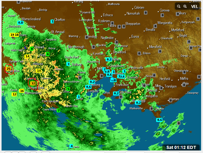
1mm on the board so far, looking pretty good for the west at this point
Re: VIC - Warming trend with dangerous fire WX - 27 - 31 Jan 2020
lightning seems to have all died, its very rare we have lightning at night these days!
- Jake Smethurst
- Supercell
- Reactions:
- Posts: 3583
- Joined: Mon Nov 23, 2009 8:49 pm
- Location: Cheltenham
Re: VIC - Warming trend with dangerous fire WX - 27 - 31 Jan 2020
Severe weather warning now current for parts of western and central Victoria. Can't say I've seen the "intense rainfall" or "dangerous and life-threatening flash flooding" tags many times before.
Severe Weather Warning
for HEAVY RAINFALL
For people in Central, South West, North Central, Wimmera and parts of West and South Gippsland Forecast Districts.
Issued at 10:47 pm Friday, 31 January 2020.
A very hot and extremely humid north to northwesterly airstream ahead a cool change moving through the State during Saturday.
INTENSE RAINFALL which may lead to dangerous and life-threatening flash flooding may develop over the western part of the warning area during tonight before extending eastwards on Saturday.
General rainfall totals of between 20mm and 40mm are expected with isolated falls to around 80mm possible.
Locations which may be affected include Horsham, Warrnambool, Seymour, Maryborough, Ballarat, Geelong and Melbourne.
Jake - Senior AWF Forecaster
Feel free to send me a private message if you have any questions.
Feel free to send me a private message if you have any questions.
- Sean
- Supercell
- Reactions:
- Posts: 1000
- Joined: Mon Feb 27, 2012 6:35 pm
- Location: Patterson Lakes - SE Melb
Re: VIC - Warming trend with dangerous fire WX - 27 - 31 Jan 2020
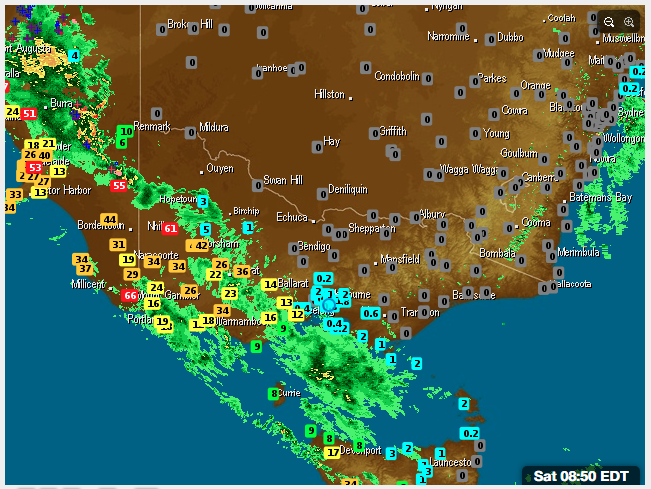
Incredible incursion of tropical moisture marching through SE oz right now. Precip values are almost topping the charts from Cape York to Tas.
- wolfcat
- Cumulonumbus Calvas
- Reactions:
- Posts: 562
- Joined: Sun Mar 07, 2010 12:14 pm
- Location: Bentleigh East
- Contact:
Re: VIC - Warming trend with dangerous fire WX - 27 - 31 Jan 2020
Some nice totals starting to build


other places you will find me...
My blog...http://www.wolfcat.com.au/randomrants/
Flickr .. http://www.flickr.com/photos/wolfcat_aus/
Twitter... http://twitter.com/wolfcat
Redbubble... http://www.redbubble.com/people/wolfcat
My blog...http://www.wolfcat.com.au/randomrants/
Flickr .. http://www.flickr.com/photos/wolfcat_aus/
Twitter... http://twitter.com/wolfcat
Redbubble... http://www.redbubble.com/people/wolfcat
- stevco123
- Supercell
- Reactions:
- Posts: 2936
- Joined: Sat Aug 07, 2010 7:42 pm
- Location: Cranbourne 78m asl
Re: VIC - Warming trend with dangerous fire WX - 27 - 31 Jan 2020
Looking like a mostly fine day today, until about mid afternoon when there is the chance of some showers or storms.
Not very excited yet for down here.
Not very excited yet for down here.
https://www.weatherlink.com/bulletin/53 ... 76dd68e8bc: for current weather updated every 2 minutes
- hillybilly
- Site Admin/Moderator
- Reactions:
- Posts: 4986
- Joined: Thu Nov 26, 2009 7:26 am
- Location: Howden Tasmania, 25m above sea level
- Contact:
Re: VIC - Warming trend with dangerous fire WX - 27 - 31 Jan 2020
Record humidity over Adelaide last night with a precipitable water value of 66mm. Is Melbournes turn today. Should be around 65mm just before noon. The record is 64.7mm back in 2011 and from memory there is nothing north of 60mm before that event. Peak values rise by about 8% for each degree warmer the oceans get, so about 10% of this value is a simple result that our oceans are hotter now. “Good news” for those who like storms, bad news if you are trying to sleep or flood prone. The dew point record for Melbourne is 24.0C and Victoria is 26.0C back in that December 2016 event. I’d be surprised if they don’t both fall today.
Nice upgrade across the models with EC, UK, GFS and CMC now all showing lots for central areas. Will be a bit thundery, but expecting this will broaden into rain so everywhere should get a decent drink. EC which I find is excellent has the first sparks around central just before 11am and then scattered activity well into the evening. The surface trough is now on the southwest coast so we should see the rainband creep east.
1.4mm here overnight, so Feb off to a start. Best in the state so far is Nhill with 58mm. Suspect a few spots will be near the ton by 9am
So many wierd records being set atm. Yesterday Melbourne saw a combination T/Td of 40C and 19C. That’s the first time we’ve had a dew point north of 18C with a temperature above 38C...
- StratoBendigo
- Supercell
- Reactions:
- Posts: 2809
- Joined: Fri Jan 02, 2015 2:18 pm
- Location: Kangaroo Flat
Re: VIC - Warming trend with dangerous fire WX - 27 - 31 Jan 2020
No rain here yet. Perhaps a couple of mm this afternoon. We've missed everything in the past month. Let's add a fourth failure in a row.
Re: VIC - Warming trend with dangerous fire WX - 27 - 31 Jan 2020
We were always borderline here Strato going by the models, just the way It happens, our time will come.
I don't know what to expect today.
By the way has it been noticed before that there is a link up for the new radar at Rainbow,( Mildura and Mnt gambier radars).
Meant to be operational by April
I don't know what to expect today.
By the way has it been noticed before that there is a link up for the new radar at Rainbow,( Mildura and Mnt gambier radars).
Meant to be operational by April
- wolfcat
- Cumulonumbus Calvas
- Reactions:
- Posts: 562
- Joined: Sun Mar 07, 2010 12:14 pm
- Location: Bentleigh East
- Contact:
Re: VIC - Warming trend with dangerous fire WX - 27 - 31 Jan 2020
Some really useful totals for part of Victoria over night.


other places you will find me...
My blog...http://www.wolfcat.com.au/randomrants/
Flickr .. http://www.flickr.com/photos/wolfcat_aus/
Twitter... http://twitter.com/wolfcat
Redbubble... http://www.redbubble.com/people/wolfcat
My blog...http://www.wolfcat.com.au/randomrants/
Flickr .. http://www.flickr.com/photos/wolfcat_aus/
Twitter... http://twitter.com/wolfcat
Redbubble... http://www.redbubble.com/people/wolfcat
- Horts
- Cumulonimbus
- Reactions:
- Posts: 238
- Joined: Mon Sep 26, 2016 12:25 pm
- Location: Safety Beach (Home) / Mount Waverley (Work) / Cowes (Beach House)
Re: VIC - Warming trend with dangerous fire WX - 27 - 31 Jan 2020
Nothing down here yet, just went for a dip in the bay. Awesome morning. Nice and humid.
Surprised though, thought it would be raining by now?
Surprised though, thought it would be raining by now?
- snowfall
- Supercell
- Reactions:
- Posts: 1286
- Joined: Mon Mar 20, 2017 7:39 pm
- Location: Gisborne South (349m asl)
Re: VIC - Warming trend with dangerous fire WX - 27 - 31 Jan 2020
3.4mm here so far, mostly from a couple of heavy showers yesterday afternoon and evening. Currently 25.7c and DP 20.9c, so there's plenty of moisture in the air! The DP down at Geelong is 24.4c, so it's getting up there.
- Jake Smethurst
- Supercell
- Reactions:
- Posts: 3583
- Joined: Mon Nov 23, 2009 8:49 pm
- Location: Cheltenham
Re: VIC - Warming trend with dangerous fire WX - 27 - 31 Jan 2020
Should see showers or rain develop late this morning and into the afternoon for central parts including Melbourne, including risk of storms. Not everybody will see the heavy falls though.
Here's what EC thinks for today, but any convective activity will result in higher falls. EC animation at 1hr intervals for today.
Here's what EC thinks for today, but any convective activity will result in higher falls. EC animation at 1hr intervals for today.
Jake - Senior AWF Forecaster
Feel free to send me a private message if you have any questions.
Feel free to send me a private message if you have any questions.
- Didjman
- Supercell
- Reactions:
- Posts: 2099
- Joined: Fri Sep 03, 2010 2:52 pm
- Location: Wallan, Vic 328m ASL
- Contact:
Re: VIC - Warming trend with dangerous fire WX - 27 - 31 Jan 2020
On the 1700Z sounding yesterday for Melbourne, it was at 50,000ft!hillybilly wrote: ↑Fri Jan 31, 2020 5:18 am
.... with the tropopause at levels usually only seen in the deep tropics. I’ve only seen this once before in the January 2011 event.
- stevco123
- Supercell
- Reactions:
- Posts: 2936
- Joined: Sat Aug 07, 2010 7:42 pm
- Location: Cranbourne 78m asl
Re: VIC - Warming trend with dangerous fire WX - 27 - 31 Jan 2020
A quick 5mm from that blob. Doesn't look promising on radar behind it, although the ridiculously humid air and an incoming trough makes ne confident we'll pull another 5mm from it
https://www.weatherlink.com/bulletin/53 ... 76dd68e8bc: for current weather updated every 2 minutes
- stevco123
- Supercell
- Reactions:
- Posts: 2936
- Joined: Sat Aug 07, 2010 7:42 pm
- Location: Cranbourne 78m asl
Re: VIC - Warming trend with dangerous fire WX - 27 - 31 Jan 2020
Tropical downpours from time to time now. Looks to be back building too

https://www.weatherlink.com/bulletin/53 ... 76dd68e8bc: for current weather updated every 2 minutes
- StratoBendigo
- Supercell
- Reactions:
- Posts: 2809
- Joined: Fri Jan 02, 2015 2:18 pm
- Location: Kangaroo Flat
Re: VIC - Warming trend with dangerous fire WX - 27 - 31 Jan 2020
Still nothing. All too South of here. Fail.
- weathergasm
- Cumulonimbus
- Reactions:
- Posts: 244
- Joined: Sun Feb 14, 2010 9:32 pm
- Location: Box Hill
Re: VIC - Warming trend with dangerous fire WX - 27 - 31 Jan 2020
If I had to guess at this stage, I’d be surprised if Melbourne got to 10mm today. The cold front is knocking on the city’s door right now and it’s hard to see how once the front passes much rain will will eventuate.
- Didjman
- Supercell
- Reactions:
- Posts: 2099
- Joined: Fri Sep 03, 2010 2:52 pm
- Location: Wallan, Vic 328m ASL
- Contact:
Re: VIC - Warming trend with dangerous fire WX - 27 - 31 Jan 2020
Not looking great here either atm. 0.4mm so far for the event.
2300z sounding has TT 42, PW 60.4mm, Li -1.4. There is an inversion between 4000ft & 5000ft. Above that, the atmosphere looks to be saturated to 22000ft.
2300z sounding has TT 42, PW 60.4mm, Li -1.4. There is an inversion between 4000ft & 5000ft. Above that, the atmosphere looks to be saturated to 22000ft.
