Mate that was epic, thanks heaps!
Now hoping it doesn't come to fruition, this side of the bay has copped it enough for this season.
Keeping a keen eye on this thread, thanks again for explaining mate, much appreciated!!

Welcome New Members! We want to hear from you. Register, stop lurking and start posting!
Climate Driver Discussion 2019 (Enso, IOD, PDO , SAM)
-
Didjman

- Supercell
- Reactions:
- Posts: 2100
- Joined: Fri Sep 03, 2010 2:52 pm
- Location: Wallan, Vic 328m ASL
- Contact:
Re: Climate Driver Discussion 2019 (Enso, IOD, PDO , SAM)
BTW, AWESOME questions; there must be others asking similar
Happy to help
-
Didjman
- Supercell
- Reactions:
- Posts: 2100
- Joined: Fri Sep 03, 2010 2:52 pm
- Location: Wallan, Vic 328m ASL
- Contact:
Re: Climate Driver Discussion 2019 (Enso, IOD, PDO , SAM)
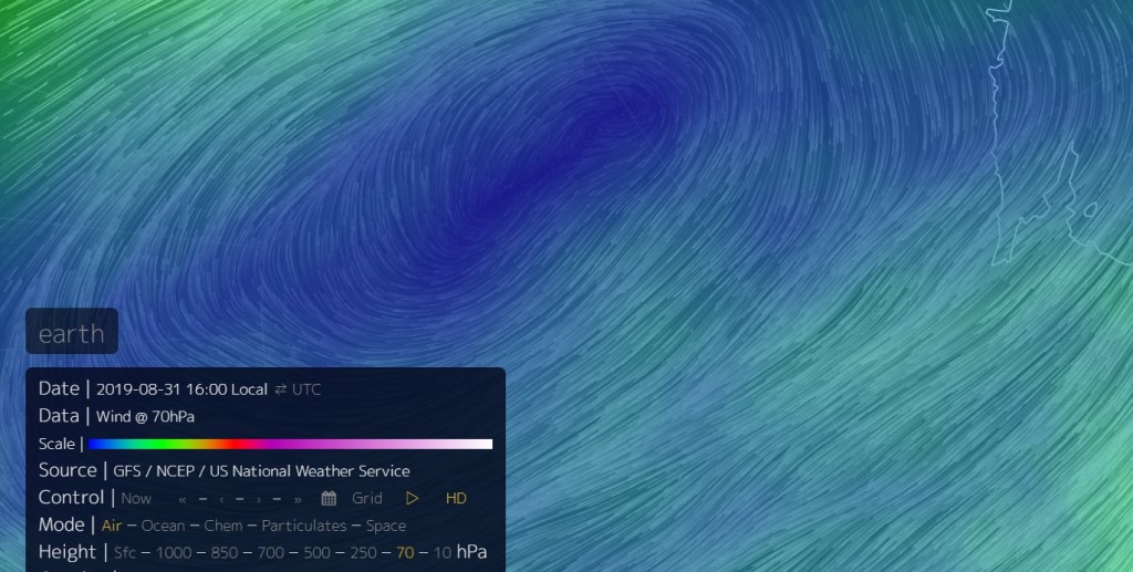
At 10 hpa, things are becoming interesting. The vortex is displaced from the Pole(has been for a couple of days), and has several convergence lines funneling in to a messy vortex - as of 2200 local time.
https://earth.nullschool.net/#current/w ... 98.03,1950
https://earth.nullschool.net/#current/w ... 98.03,1950
-
Didjman
- Supercell
- Reactions:
- Posts: 2100
- Joined: Fri Sep 03, 2010 2:52 pm
- Location: Wallan, Vic 328m ASL
- Contact:
Re: Climate Driver Discussion 2019 (Enso, IOD, PDO , SAM)
It has now dropped further sitting at around 24000 ft. Will be interesting to see the chart for 2300Z; is the lowering a trend (coupling)?
-
Didjman
- Supercell
- Reactions:
- Posts: 2100
- Joined: Fri Sep 03, 2010 2:52 pm
- Location: Wallan, Vic 328m ASL
- Contact:
Re: Climate Driver Discussion 2019 (Enso, IOD, PDO , SAM)
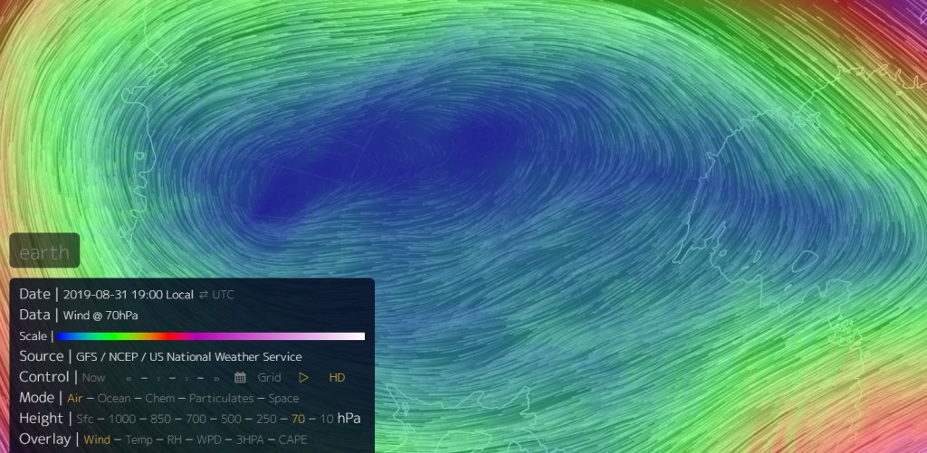
At 70hpa, the vortex is almost splitting again:
Re: Climate Driver Discussion 2019 (Enso, IOD, PDO , SAM)
Thanks Folks for showing us this and the explanations.
On the 10 hpa level it shows an extra circulation just to the south of Aus, which is
sort of showing in the 70 hpa level.
Does this mean anything?
Cheers
On the 10 hpa level it shows an extra circulation just to the south of Aus, which is
sort of showing in the 70 hpa level.
Does this mean anything?
Cheers
-
Didjman
- Supercell
- Reactions:
- Posts: 2100
- Joined: Fri Sep 03, 2010 2:52 pm
- Location: Wallan, Vic 328m ASL
- Contact:
Re: Climate Driver Discussion 2019 (Enso, IOD, PDO , SAM)
Hi Hawker,
that circulation you refer to is the anticyclone you can see pushing on the circulation around the polar vortex. This is altering the wind direction as you can see. Where the 2 systems are interacting is where the heating is occurring (see my post with graphic last night).
-
Didjman
- Supercell
- Reactions:
- Posts: 2100
- Joined: Fri Sep 03, 2010 2:52 pm
- Location: Wallan, Vic 328m ASL
- Contact:
Re: Climate Driver Discussion 2019 (Enso, IOD, PDO , SAM)
At 2300Z it appears the tropopause has shot back up to 35000ft.
-
Didjman
- Supercell
- Reactions:
- Posts: 2100
- Joined: Fri Sep 03, 2010 2:52 pm
- Location: Wallan, Vic 328m ASL
- Contact:
Re: Climate Driver Discussion 2019 (Enso, IOD, PDO , SAM)
Polar vortex under serious stress at 70hpa 0800Z. The core has been shoved well away from the pole in the last 3hrs!
-
Didjman
- Supercell
- Reactions:
- Posts: 2100
- Joined: Fri Sep 03, 2010 2:52 pm
- Location: Wallan, Vic 328m ASL
- Contact:
Re: Climate Driver Discussion 2019 (Enso, IOD, PDO , SAM)
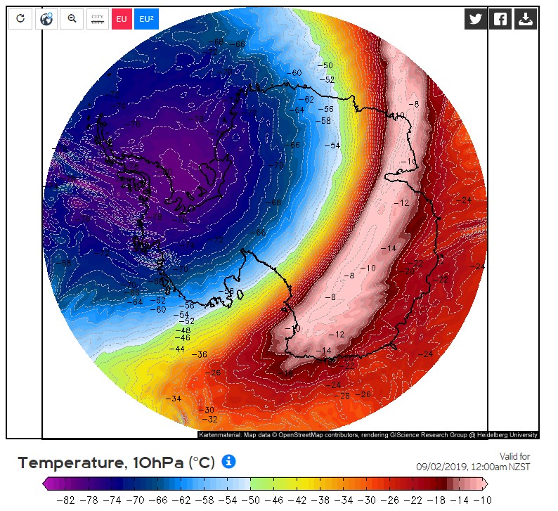
For now it looks like the SSW has passed its peak from this graphic for 10 hpa - fcast max temps are back below zero celsius:
- JasmineStorm
- Supercell
- Reactions:
- Posts: 1870
- Joined: Thu Sep 22, 2016 9:40 pm
- Location: Kyneton 527 ASL
Re: Climate Driver Discussion 2019 (Enso, IOD, PDO , SAM)
GFS showing a mini stratospheric vortex and an out of control polar jet cut loose within the tropospheric polar vortex towards the equinox. Big cracks are beginning to appear 
- Attachments
-
- GFS mid Sep PV structure.jpg (203.59 KiB) Viewed 8781 times
-
Didjman
- Supercell
- Reactions:
- Posts: 2100
- Joined: Fri Sep 03, 2010 2:52 pm
- Location: Wallan, Vic 328m ASL
- Contact:
Re: Climate Driver Discussion 2019 (Enso, IOD, PDO , SAM)
Hi JS, where do you see the polar jet in that graphic, or is that in something else?? Are you referring to the 2 lobes at the bottom??
- JasmineStorm
- Supercell
- Reactions:
- Posts: 1870
- Joined: Thu Sep 22, 2016 9:40 pm
- Location: Kyneton 527 ASL
Re: Climate Driver Discussion 2019 (Enso, IOD, PDO , SAM)
Yes, correct. You will see the polar jet start to jag out at the bottom in multiple locations as major propagating Rossby waves head equatorward. The stratospheric vortex is weakening and shrinking at this stage.
-
Didjman
- Supercell
- Reactions:
- Posts: 2100
- Joined: Fri Sep 03, 2010 2:52 pm
- Location: Wallan, Vic 328m ASL
- Contact:
Re: Climate Driver Discussion 2019 (Enso, IOD, PDO , SAM)
Thx for that JS, I have noticed the shrinking. That forecast graphic, is that freeware access??
I have started to include the SAM and 3d Vortex structure graphics in my blog to show the changes as the event unfolds.
I have started to include the SAM and 3d Vortex structure graphics in my blog to show the changes as the event unfolds.
- Rhys_34
- Cumulonimbus
- Reactions:
- Posts: 207
- Joined: Sat Jan 09, 2010 3:53 pm
- Location: Sheffield, Canterbury, New Zealand 300m asl
Re: Climate Driver Discussion 2019 (Enso, IOD, PDO , SAM)
Latest GFS analysis of the polar jet stream at 70hpa is showing an almighty distortion of the polar vortex turning the circulation into an almost oblong shape and a shift of the centre of the vortex to almost off the coast of Antarctica. You can also see a large bulge of the jetstream towards Chile, this combined with severely diminished wind values of 128kmh in the eastern flank compared with 270kmh for the rest of the jetstream equals to an almighty attack on the jetsream from the stratosphere above. This is just the beginning as well, we could well see a complete disintegration of the polar vortex in 2-3 weeks time at this rate. What this would mean for southern areas of Australia with the protection of the polar vortex gone and copious amounts of polar air spilling out into the southern ocean remains unseen but this combined with a negative AAO value, a solar minimum as well as the traditional spring volatility is anyone's guess but I think we can safely say we are about to see something that has never been seen before in modern times...
- Attachments
-
- 2.jpg (526.13 KiB) Viewed 8665 times
-
Didjman
- Supercell
- Reactions:
- Posts: 2100
- Joined: Fri Sep 03, 2010 2:52 pm
- Location: Wallan, Vic 328m ASL
- Contact:
Re: Climate Driver Discussion 2019 (Enso, IOD, PDO , SAM)
That possibility has crossed my mind also. The Polar Jet is really ramping up already.
-
Didjman
- Supercell
- Reactions:
- Posts: 2100
- Joined: Fri Sep 03, 2010 2:52 pm
- Location: Wallan, Vic 328m ASL
- Contact:
Re: Climate Driver Discussion 2019 (Enso, IOD, PDO , SAM)
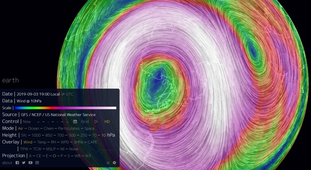
At 10hpa, the Polar Vortex is having the life squeezed out of it as it continues shrinking!
Look at the Polar Jetstream cut loose between Africa and Oz at 500hpa! This area between Africa and OZ is where the waves of heat erupting into the stratosphere originated:
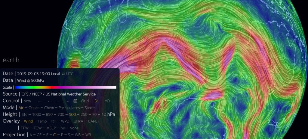
We have a drop in the Tropopause-7000ft in 12 hrs over Melbourne. No fronts have gone through.
Look at the Polar Jetstream cut loose between Africa and Oz at 500hpa! This area between Africa and OZ is where the waves of heat erupting into the stratosphere originated:
We have a drop in the Tropopause-7000ft in 12 hrs over Melbourne. No fronts have gone through.
-
Didjman
- Supercell
- Reactions:
- Posts: 2100
- Joined: Fri Sep 03, 2010 2:52 pm
- Location: Wallan, Vic 328m ASL
- Contact:
Re: Climate Driver Discussion 2019 (Enso, IOD, PDO , SAM)
We have 2 circulations at 70 hpa and as mentioned earlier the jet looks sick(ill)
- Rhys_34
- Cumulonimbus
- Reactions:
- Posts: 207
- Joined: Sat Jan 09, 2010 3:53 pm
- Location: Sheffield, Canterbury, New Zealand 300m asl
Re: Climate Driver Discussion 2019 (Enso, IOD, PDO , SAM)
The polar vortex has weakened another 20% on the eastern flank near the southern coast of Chile overnight with winds at 70hpa only registering 94kmh!! There is also an emergence of another secondary circulation above the primary, another sign of a weakening vortex. Things are really getting interesting now!
- Attachments
-
- 6.jpg (543.65 KiB) Viewed 8491 times
-
Didjman
- Supercell
- Reactions:
- Posts: 2100
- Joined: Fri Sep 03, 2010 2:52 pm
- Location: Wallan, Vic 328m ASL
- Contact:
Re: Climate Driver Discussion 2019 (Enso, IOD, PDO , SAM)
The last time the center split a couple of weeks ago, the outer winds remained firm and complete around both vortices