No worries. Gpm is geopotential metres

Welcome New Members! We want to hear from you. Register, stop lurking and start posting!
Climate Driver Discussion 2019 (Enso, IOD, PDO , SAM)
- JasmineStorm
- Supercell
- Reactions:
- Posts: 1870
- Joined: Thu Sep 22, 2016 9:40 pm
- Location: Kyneton 527 ASL
-
Didjman

- Supercell
- Reactions:
- Posts: 2099
- Joined: Fri Sep 03, 2010 2:52 pm
- Location: Wallan, Vic 328m ASL
- Contact:
Re: Climate Driver Discussion 2019 (Enso, IOD, PDO , SAM)
On lattest Melbourne sounding, tropopause has dropped nearly 2klm in 12hrs! After a smaller drop previous 12hrs
-
Didjman
- Supercell
- Reactions:
- Posts: 2099
- Joined: Fri Sep 03, 2010 2:52 pm
- Location: Wallan, Vic 328m ASL
- Contact:
Re: Climate Driver Discussion 2019 (Enso, IOD, PDO , SAM)
At 0900this morning the tropopause was at around 10klm. As the lower stratosphere warms up, it heats the upper levels of the troposphere causing the boundary between them (tropopause) to lower.
-
Didjman
- Supercell
- Reactions:
- Posts: 2099
- Joined: Fri Sep 03, 2010 2:52 pm
- Location: Wallan, Vic 328m ASL
- Contact:
Re: Climate Driver Discussion 2019 (Enso, IOD, PDO , SAM)
Again, the tropopause has dropped, albeit approx half a klm in last 12 hrs. That makes a dropping trend for at least the last 36hrs for Hobart, Melbourne and Sydney. Adelaides latest chart is incomplete.
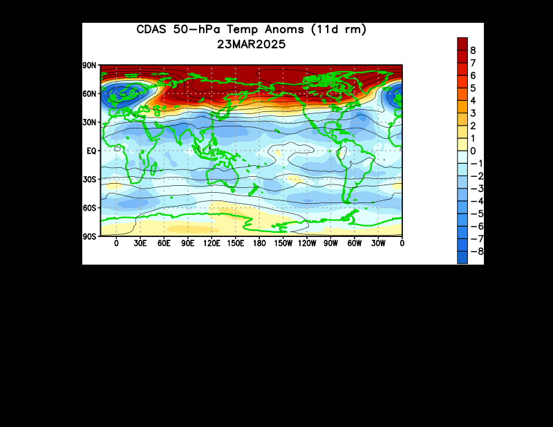
Also, the below link shows the warming anomoly has become stationary between Africa and OZ (prolonging the effects of stratospheric warming):
https://www.cpc.ncep.noaa.gov/products/ ... 50anim.gif
Also, the below link shows the warming anomoly has become stationary between Africa and OZ (prolonging the effects of stratospheric warming):
https://www.cpc.ncep.noaa.gov/products/ ... 50anim.gif
-
crikey

- Supercell
- Reactions:
- Posts: 1314
- Joined: Mon Feb 07, 2011 8:02 pm
- Location: tweed shire NSW and nDUNOLLY.. Nth Central district VIC
- Contact:
Re: Climate Driver Discussion 2019 (Enso, IOD, PDO , SAM)
Thanks for that observation re the stationary temp',anomaly at 50hpa. How curious.Didjman wrote: ↑Wed Jul 17, 2019 11:43 am Again, the tropopause has dropped, albeit approx half a klm in last 12 hrs. That makes a dropping trend for at least the last 36hrs for Hobart, Melbourne and Sydney. Adelaides latest chart is incomplete.
Also, the below link shows the warming anomoly has become stationary between Africa and OZ (prolonging the effects of stratospheric warming):
https://www.cpc.ncep.noaa.gov/products/ ... 50anim.gif
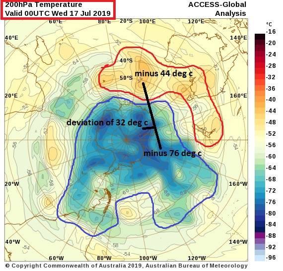
In return and my appreciation .,Here is the temps ,,current at 200hpa
It may be fair to say that those 50hpa anomalies extend down to the 200hpa layer.
-
Didjman
- Supercell
- Reactions:
- Posts: 2099
- Joined: Fri Sep 03, 2010 2:52 pm
- Location: Wallan, Vic 328m ASL
- Contact:
Re: Climate Driver Discussion 2019 (Enso, IOD, PDO , SAM)
And the Tropopause appears to be on a lowering trend! What will the Polar Vortex do? We should know in a week. If I have taken on board what JS has taught me (many thx JS!), it could split again, then real winter returns around end of the month!
JS, what are your thoughts??
-
crikey
- Supercell
- Reactions:
- Posts: 1314
- Joined: Mon Feb 07, 2011 8:02 pm
- Location: tweed shire NSW and nDUNOLLY.. Nth Central district VIC
- Contact:
Re: Climate Driver Discussion 2019 (Enso, IOD, PDO , SAM)
The last and only ever polar vortex split recorded in the SH was in september 2002.
There is documentary on www if you google.
.........
Here are dew points for our continent currently..WOW
Wide spread low dry values.. Even in the oceans!
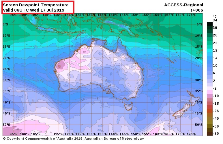
source
http://www.bom.gov.au/australia/charts/ ... fresh+View
There is documentary on www if you google.
.........
Here are dew points for our continent currently..WOW
Wide spread low dry values.. Even in the oceans!
source
http://www.bom.gov.au/australia/charts/ ... fresh+View
-
Didjman
- Supercell
- Reactions:
- Posts: 2099
- Joined: Fri Sep 03, 2010 2:52 pm
- Location: Wallan, Vic 328m ASL
- Contact:
Re: Climate Driver Discussion 2019 (Enso, IOD, PDO , SAM)
On the 1100Z 17 July melbourne sounding, the tropopause had dropped to 7klm or 23000ft - down from 10.5klm/34000ft -12hrs earlier.
JS, what is your take on this??
- JasmineStorm
- Supercell
- Reactions:
- Posts: 1870
- Joined: Thu Sep 22, 2016 9:40 pm
- Location: Kyneton 527 ASL
Re: Climate Driver Discussion 2019 (Enso, IOD, PDO , SAM)
Hi Criky, what is your definition of a vortex split? The 2002 event was a full vortex split. As posted at the beginning of the thread, this was a lower stratopsheric vortex split/separation as seen on the observations of 2 spinning vortices at 50 hPa, which lowered the tropopause and was the behind 3 foot snow dump into the Alps. A similar event triggered the once in 20 year snow event at the end of May.
@Didjman, I'm still reviewing this next event. Not all the pieces have come into place yet.
-
Didjman
- Supercell
- Reactions:
- Posts: 2099
- Joined: Fri Sep 03, 2010 2:52 pm
- Location: Wallan, Vic 328m ASL
- Contact:
Re: Climate Driver Discussion 2019 (Enso, IOD, PDO , SAM)
Hi JS,
Apart from the polar vortex being "whole" atm, what other pieces are missing? Loving this learning curve btw
Apart from the polar vortex being "whole" atm, what other pieces are missing? Loving this learning curve btw
- JasmineStorm
- Supercell
- Reactions:
- Posts: 1870
- Joined: Thu Sep 22, 2016 9:40 pm
- Location: Kyneton 527 ASL
Re: Climate Driver Discussion 2019 (Enso, IOD, PDO , SAM)
Hi Didjman, IMO, another crucial piece of the puzzle is the Rossby wave or commonly known as the long wave trough. It needs to propagate at the right time into SE OZ to deliver the cold snap. If the timing doesn't line up, it peaks east or west. The crucial level to look at is 500 hPa on the charts. Weatherzone have free polar charts they produce everyday which is a nice a quick way to see what might be in the pipeline
https://www.weatherzone.com.au/models/? ... here&lc=sh
Can't be taken too seriously until it gets within 120 hours imo.
-
Didjman
- Supercell
- Reactions:
- Posts: 2099
- Joined: Fri Sep 03, 2010 2:52 pm
- Location: Wallan, Vic 328m ASL
- Contact:
Re: Climate Driver Discussion 2019 (Enso, IOD, PDO , SAM)
The LWT, course. Had forgotten that  Makes sense.
-
crikey
- Supercell
- Reactions:
- Posts: 1314
- Joined: Mon Feb 07, 2011 8:02 pm
- Location: tweed shire NSW and nDUNOLLY.. Nth Central district VIC
- Contact:
Re: Climate Driver Discussion 2019 (Enso, IOD, PDO , SAM)
Is 50hpathe lower stratospher?JasmineStorm wrote: ↑Thu Jul 18, 2019 6:48 am
Hi Criky, what is your definition of a vortex split? The 2002 event was a full vortex split. As posted at the beginning of the thread, this was a lower stratopsheric vortex split/separation as seen on the observations of 2 spinning vortices at 50 hPa, which lowered the tropopause and was the behind 3 foot snow dump into the Alps. A similar event triggered the once in 20 year snow event at the end of May.
@Didjman, I'm still reviewing this next event. Not all the pieces have come into place yet.
My definition of a vortex split is the same as yours l,suspect.,The formation of 2 vortices. We saw that on the null,school wind streams
I have been documenting this event since your first observations Here
https://weathercycles.wordpress.com/201 ... nd-onward/
The research l read on the 2002 event Esler et al 2006 ,described a split at the uppers, if l remember.But would newe to read more widely l suspect to get a better handle on what went on back in 2002.
My take' or observations show evidence of split from top to bottom with a sort of bottle neck shape at around 200hpa
....
re.. " A similar event triggered the once in 20 year snow event at the end of May'
Was there.. another PV split...at 50hpa back in May 2019 as seen on null school windstreams?
- JasmineStorm
- Supercell
- Reactions:
- Posts: 1870
- Joined: Thu Sep 22, 2016 9:40 pm
- Location: Kyneton 527 ASL
Re: Climate Driver Discussion 2019 (Enso, IOD, PDO , SAM)
050 to 100 hPa is mid to lower strat. Strat heights varies between Poles and equator as well. Don't have a nullschool shot but here is the disturbance at 050 hPa from 11th May caught on GEFS ensemble. Flushed out in late May into the mid latitudes for the biggest Alps May snowfall since the year 2000.crikey wrote: ↑Thu Jul 18, 2019 9:04 amIs 50hpathe lower stratospher?JasmineStorm wrote: ↑Thu Jul 18, 2019 6:48 am
Hi Criky, what is your definition of a vortex split? The 2002 event was a full vortex split. As posted at the beginning of the thread, this was a lower stratopsheric vortex split/separation as seen on the observations of 2 spinning vortices at 50 hPa, which lowered the tropopause and was the behind 3 foot snow dump into the Alps. A similar event triggered the once in 20 year snow event at the end of May.
@Didjman, I'm still reviewing this next event. Not all the pieces have come into place yet.
My definition of a vortex split is the same as yours l,suspect.,The formation of 2 vortices. We saw that on the null,school wind streams
I have been documenting this event since your first observations Here
https://weathercycles.wordpress.com/201 ... nd-onward/
The research l read on the 2002 event Esler et al 2006 ,described a split at the uppers, if l remember.But would newe to read more widely l suspect to get a better handle on what went on back in 2002.
My take' or observations show evidence of split from top to bottom with a sort of bottle neck shape at around 200hpa
....
re.. " A similar event triggered the once in 20 year snow event at the end of May'
Was there.. another PV split...at 50hpa back in May 2019 as seen on null school windstreams?
- Attachments
-
- 050 hPa strat 11 May.jpg (316.99 KiB) Viewed 6405 times
-
Didjman
- Supercell
- Reactions:
- Posts: 2099
- Joined: Fri Sep 03, 2010 2:52 pm
- Location: Wallan, Vic 328m ASL
- Contact:
Re: Climate Driver Discussion 2019 (Enso, IOD, PDO , SAM)
Latest Melbourne sounding has tropopause back up to 11klms/36000ft as of 2300z
-
Didjman
- Supercell
- Reactions:
- Posts: 2099
- Joined: Fri Sep 03, 2010 2:52 pm
- Location: Wallan, Vic 328m ASL
- Contact:
Re: Climate Driver Discussion 2019 (Enso, IOD, PDO , SAM)
The Stratobserve site has not updated since 14 July
- JasmineStorm
- Supercell
- Reactions:
- Posts: 1870
- Joined: Thu Sep 22, 2016 9:40 pm
- Location: Kyneton 527 ASL
-
Didjman
- Supercell
- Reactions:
- Posts: 2099
- Joined: Fri Sep 03, 2010 2:52 pm
- Location: Wallan, Vic 328m ASL
- Contact:
Re: Climate Driver Discussion 2019 (Enso, IOD, PDO , SAM)
Thx for the update JSJasmineStorm wrote: ↑Thu Jul 18, 2019 5:04 pmThe scientist who runs the site is aware but is currently writing a paper and won't be able to fix the feed for a few more days.
-
crikey
- Supercell
- Reactions:
- Posts: 1314
- Joined: Mon Feb 07, 2011 8:02 pm
- Location: tweed shire NSW and nDUNOLLY.. Nth Central district VIC
- Contact:
Re: Climate Driver Discussion 2019 (Enso, IOD, PDO , SAM)
Yes 'JS'. I did notice some eye brow raising anomalies as early as April and May.
And , today l found some eye raising anomalies in the 'strat' as far back as January.2019
However at this stage l have not enough knowledge to assess how much of that is seasonal variation.
So l thought l would collect as much data as l could and then you have it for analysis later.
There is evidence of post split anomalies as well.
Maybe l post what l found tonight which l believe relates to what 'didjman' is watching.
The tropopause height over Melbourne.,10km..
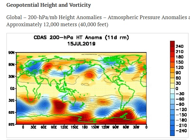
If that can be seen by the geopotential height maps, then this map below shows a wave like pattern is underway.
It is interesting to know that this anomaly.... started....from the 7th July , ( center of vortex split )
and is still underway.
The repurcussions????
Will be on the lookout..
And , today l found some eye raising anomalies in the 'strat' as far back as January.2019
However at this stage l have not enough knowledge to assess how much of that is seasonal variation.
So l thought l would collect as much data as l could and then you have it for analysis later.
There is evidence of post split anomalies as well.
Maybe l post what l found tonight which l believe relates to what 'didjman' is watching.
The tropopause height over Melbourne.,10km..
If that can be seen by the geopotential height maps, then this map below shows a wave like pattern is underway.
It is interesting to know that this anomaly.... started....from the 7th July , ( center of vortex split )
and is still underway.
The repurcussions????
Will be on the lookout..