Welcome New Members! We want to hear from you. Register, stop lurking and start posting!

Victoria: Significant rain event - November 4-10 2018

Archived Weather Events since 2009.
If you have any valuable content to add to any locked thread, please PM board moderator.
Locked
User avatar
hillybilly
Site Admin/Moderator
Reactions:
Posts: 4980
Joined: Thu Nov 26, 2009 7:26 am
Location: Howden Tasmania, 25m above sea level
Contact:

Victoria: Significant rain event - November 4-10 2018

Post by hillybilly »

Complex sequence coming up with a strong upper trough and low to our west throwing a series of moist troughs across Victoria with potential for a cold outbreak late in the week. Looks mostly fine on Sunday, though perhaps the odds shower then widespread rain, showers and storms for Monday and Tuesday. Rain looks quite heavy in the northeast, northern slopes and possibly east central. Still a few days out so may well change.

A showery few days to follow.

Should see widespread 20-50mm falls for the week, but after a year of fizzer's perhaps we should expect half that ;)
G
Gordon
Supercell
Reactions:
Posts: 2888
Joined: Thu Jun 17, 2010 10:01 am
Location: Near Gordon, Vic. 620 m asl

Re: Significant rain event: November 4-10

Post by Gordon »

Just enough to keep the grass green from today's falls so really hoping this one produces...
S
StratoBendigo
Supercell
Reactions:
Posts: 2809
Joined: Fri Jan 02, 2015 2:18 pm
Location: Kangaroo Flat

Re: Significant rain event: November 4-10

Post by StratoBendigo »

Incremental downgrades overnight - that's a worry.

Perhaps 20-30mm, but not surprised if ends up half that amount.
T
Tassiedave
Supercell
Reactions:
Posts: 1098
Joined: Thu Nov 11, 2010 11:09 am
Location: Grindelwald Tasmania

Re: Significant rain event: November 4-10

Post by Tassiedave »

How is the weather looking for the Melbourne Cup Tuesday afternoon?
S
Skywalker
Supercell
Reactions:
Posts: 1871
Joined: Sun Nov 29, 2009 10:03 am
Location: Burnside Heights/Cowes (Home) & Sunshine West (Work)

Re: Significant rain event: November 4-10

Post by Skywalker »

StratoBendigo wrote: Sat Nov 03, 2018 8:32 am Incremental downgrades overnight - that's a worry.

Perhaps 20-30mm, but not surprised if ends up half that amount.

Will no doubt be yet another fizzer. I have zero confidence in the weather atm. Only one thing will be guaranteed, more bloody wind! :x
Caroline Springs, Melbourne's meteorological boredom zone.
User avatar
hillybilly
Site Admin/Moderator
Reactions:
Posts: 4980
Joined: Thu Nov 26, 2009 7:26 am
Location: Howden Tasmania, 25m above sea level
Contact:

Re: Significant rain event: November 4-10

Post by hillybilly »

Progs doing there typically jumps and downgrades. Still looks big for northeast Vic, with EC showing widespread 50-100mm. Rest of us wait to see how the details pan out. CMC, GFS and EC al have somewhere between 20 and 40mm for most of central Vic, but tight gradients so could be a good event or dribbles which save watering for a week.

Focus has shifted more towards Monday with showers on Tuesday tending to be more in the east, but guess that could change.

Currently got mizzle here in Walkerville with humid conditions. Bit of rain approaching the far west.
J
JasmineStorm
Supercell
Reactions:
Posts: 1870
Joined: Thu Sep 22, 2016 9:40 pm
Location: Kyneton 527 ASL

Re: Significant rain event: November 4-10

Post by JasmineStorm »

Hard to keep up with the constant changes in the models. EC sending a water bomb to the North East but EC has been ordinary of late for Vic. I thought this was interesting, Access R in the last 6 hours did a large shift westward for rain and storms up until Wednesday.
Attachments
Access R 0311 18Z.jpg
Access R 0311 18Z.jpg (367.76 KiB) Viewed 8473 times
G
Gordon
Supercell
Reactions:
Posts: 2888
Joined: Thu Jun 17, 2010 10:01 am
Location: Near Gordon, Vic. 620 m asl

Re: Significant rain event: November 4-10

Post by Gordon »

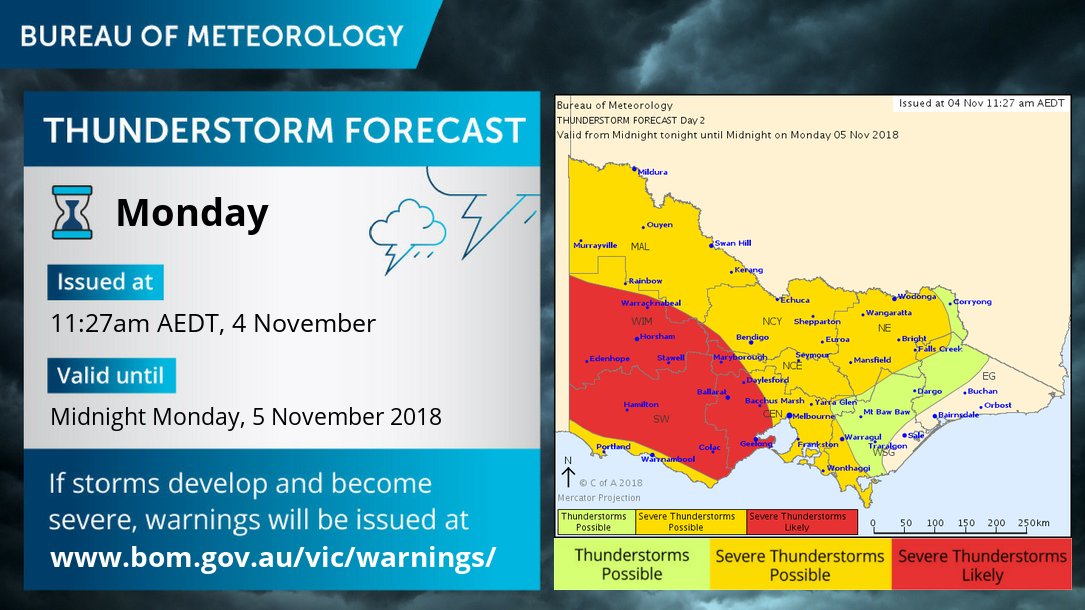
The thunderstorm forecast issued about midday today looks okay?

Image
User avatar
hillybilly
Site Admin/Moderator
Reactions:
Posts: 4980
Joined: Thu Nov 26, 2009 7:26 am
Location: Howden Tasmania, 25m above sea level
Contact:

Re: Significant rain event: November 4-10

Post by hillybilly »

Progs have come back quite well with solid 20 to 50mm for most areas. Looks best in the northeast, with central areas also looking to do well. Should see about 40mm in the Dandenongs looking at the latest Progs, but could do better if we get lucky with storms. Only need 600mm to our annual average so the more it rains the better :o

Storms look promising tomorrow. Excellent tropical indeed, decent convergence into the slow moving trough and good instability. Think any storms should be wet ones... so some potential for locally heavy falls tomorrow.

Solids falls just across the border now, so starting to take shape.
S
StratoBendigo
Supercell
Reactions:
Posts: 2809
Joined: Fri Jan 02, 2015 2:18 pm
Location: Kangaroo Flat

Re: Significant rain event: November 4-10

Post by StratoBendigo »

Storms are arcing up over South Australia atm. Lots of the right ingredients are there for us tomorrow, except that it's 2018 and it doesn't rain much...

That said, 20mm looks to be about on the money for us over the next two days. If it was most other years - double or triple it.
s
snowfall
Supercell
Reactions:
Posts: 1284
Joined: Mon Mar 20, 2017 7:39 pm
Location: Gisborne South (349m asl)

Re: Significant rain event: November 4-10

Post by snowfall »

Top of 22c here today and barely a breath of wind. Showers are now moving into central areas from the west. Really hoping we all get something decent over the next couple of days.
User avatar
hillybilly
Site Admin/Moderator
Reactions:
Posts: 4980
Joined: Thu Nov 26, 2009 7:26 am
Location: Howden Tasmania, 25m above sea level
Contact:

Re: Significant rain event: November 4-10

Post by hillybilly »

Nearing 4mm in FC and about the same at Walkerville. Looks like a rainy few days. Should add up nicely. Not huge but very welcome. Would like 50mm which is a chance but looks more like 30-40mm.
S
StratoBendigo
Supercell
Reactions:
Posts: 2809
Joined: Fri Jan 02, 2015 2:18 pm
Location: Kangaroo Flat

Re: Significant rain event: November 4-10

Post by StratoBendigo »

EC says 'fizzer' and just has 6mm for us now.

But there is light rain right now.
H
Hawker
Cumulonimbus
Reactions:
Posts: 410
Joined: Tue Jul 10, 2012 7:49 pm
Location: Castlemaine

Re: Significant rain event: November 4-10

Post by Hawker »

Hhmmm doesn't look that convincing, though I think the better rain is meant to be later or overnight.
Ended up with 8 from the last bit, if we get the same with this one I will be surprised.
J
JasmineStorm
Supercell
Reactions:
Posts: 1870
Joined: Thu Sep 22, 2016 9:40 pm
Location: Kyneton 527 ASL

Re: Significant rain event: November 4-10

Post by JasmineStorm »

Latest BoM high resolution model Access C showing a good event in the next 36 hours for a large part of Vic. 1 mm to start things off here overnight.
Attachments
Access C 0411 18Z.jpg
Access C 0411 18Z.jpg (602.59 KiB) Viewed 8000 times
S
StratoBendigo
Supercell
Reactions:
Posts: 2809
Joined: Fri Jan 02, 2015 2:18 pm
Location: Kangaroo Flat

Re: Significant rain event: November 4-10

Post by StratoBendigo »

BOM WATL only has 10-15mm in this morning's run. Sounds about right.

Access-C is well and truly on its own.

It is 2018, not 2010, so we shouldn't expect much really.
S
Skywalker
Supercell
Reactions:
Posts: 1871
Joined: Sun Nov 29, 2009 10:03 am
Location: Burnside Heights/Cowes (Home) & Sunshine West (Work)

Re: Significant rain event: November 4-10

Post by Skywalker »

Going to be a wet one down here on the Island going by the radar. We are being lined up beautifully. :D

Meanwhile back in the pathetic western desert.....NOTHING!!!! :cussing:
Caroline Springs, Melbourne's meteorological boredom zone.
A
Adam38
Cumulonimbus
Reactions:
Posts: 486
Joined: Tue Jul 31, 2018 1:57 pm
Location: Bacchus Marsh

Re: Significant rain event: November 4-10

Post by Adam38 »

A SWW has been issued for heavy rain.

http://www.bom.gov.au/products/IDV21037.shtml
J
JasmineStorm
Supercell
Reactions:
Posts: 1870
Joined: Thu Sep 22, 2016 9:40 pm
Location: Kyneton 527 ASL

Re: Significant rain event: November 4-10

Post by JasmineStorm »

I think that SWW tells you that the BoM rate there high resolution model Access C ahead of the global models :)

Having a closer look at the latest observations from the surface to upper levels of the troposphere, dew points in the Wimmera and South West have increased this morning, which should slowly creep eastward during today. Big plumes of moisture are now being detected on water vapour images in the mid levels before the trough in S.A, which is slowly moving eastward. Gravity wave clouds now appearing aloft in S.A signalling upper instability with the jet stream dipping down. Certainly has a look of localised downpours as the trough moves east

Model wise, the differences between the BoM access models 18z run and the global models 12z runs is moisture levels at 700 hPa later tonight and tomorrow morning. Access C and R are tapping into more moisture, elevating projected rainfall totals. Time will tell I suppose :)


Currently 19c with a 13c DP here.
W
Wilko
Supercell
Reactions:
Posts: 1492
Joined: Wed Aug 11, 2010 12:08 pm
Location: Moorabbin & Highett, Vic

Re: Significant rain event: November 4-10

Post by Wilko »

JasmineStorm wrote: Mon Nov 05, 2018 11:50 am I think that SWW tells you that the BoM rate there high resolution model Access C ahead of the global models :)

Having a closer look at the latest observations from the surface to upper levels of the troposphere, dew points in the Wimmera and South West have increased this morning, which should slowly creep eastward during today. Big plumes of moisture are now being detected on water vapour images in the mid levels before the trough in S.A, which is slowly moving eastward. Gravity wave clouds now appearing aloft in S.A signalling upper instability with the jet stream dipping down. Certainly has a look of localised downpours as the trough moves east

Model wise, the differences between the BoM access models 18z run and the global models 12z runs is moisture levels at 700 hPa later tonight and tomorrow morning. Access C and R are tapping into more moisture, elevating projected rainfall totals. Time will tell I suppose :)


Currently 19c with a 13c DP here.
Awesome Jasmine
Session guessing very warm and humid here
Locked