Good to see quite a few gauges around Melbourne got into double figures this morning.

Welcome New Members! We want to hear from you. Register, stop lurking and start posting!
VIC - Sequence of fronts (Part 1): August 3-13 2018
- JasmineStorm
- Supercell
- Reactions:
- Posts: 1870
- Joined: Thu Sep 22, 2016 9:40 pm
- Location: Kyneton 527 ASL
Re: Sequence of fronts: August 3-13
3mm overnight to keep things ticking over. Up to 58mm now for August on the 11th day  100 year August ave is 84mm. I have a feeling August has plenty more to come. Haven't had pressure over 1030 hPa since the change in weather pattern in early July. Only 4 frosts since.....quite unusual but that is what negative SAM's do up here.
Good to see quite a few gauges around Melbourne got into double figures this morning.
Good to see quite a few gauges around Melbourne got into double figures this morning.
- StratoBendigo
- Supercell
- Reactions:
- Posts: 2818
- Joined: Fri Jan 02, 2015 2:18 pm
- Location: Kangaroo Flat
Re: Sequence of fronts: August 3-13
Not really cold here yet. Already hit our expected Max temp. Too dry too.
- stevco123
- Supercell
- Reactions:
- Posts: 2937
- Joined: Sat Aug 07, 2010 7:42 pm
- Location: Cranbourne 78m asl
Re: Sequence of fronts: August 3-13
Slow news day at the Herald Sun. Record rain? Hahaha
https://www.heraldsun.com.au/news/victo ... 97185a5dd9
https://www.heraldsun.com.au/news/victo ... 97185a5dd9
https://www.weatherlink.com/bulletin/53 ... 76dd68e8bc: for current weather updated every 2 minutes
Re: Sequence of fronts: August 3-13
After 4mm overnight a few showers are moving through. the last
one had some small soft hail, maybe bigger showers later.
one had some small soft hail, maybe bigger showers later.
Re: Sequence of fronts: August 3-13
where is all this rain? Nothing remarkable about today, its actually quite warm out in the sun and enjoyable!
- StratoBendigo
- Supercell
- Reactions:
- Posts: 2818
- Joined: Fri Jan 02, 2015 2:18 pm
- Location: Kangaroo Flat
Re: Sequence of fronts: August 3-13
Temp dropped from 12 to 8c this afternoon. A lot colder now.
Looks like 15cm so far at Falls Creek.
Looks like 15cm so far at Falls Creek.
- Sean
- Supercell
- Reactions:
- Posts: 1000
- Joined: Mon Feb 27, 2012 6:35 pm
- Location: Patterson Lakes - SE Melb
Re: Sequence of fronts: August 3-13
Another disappointing result. The fronts seem to be skint by the time they reach this area.
YTD even lower than last year, and by a wide margin. Hoping for a turnaround
YTD even lower than last year, and by a wide margin. Hoping for a turnaround
- stevco123
- Supercell
- Reactions:
- Posts: 2937
- Joined: Sat Aug 07, 2010 7:42 pm
- Location: Cranbourne 78m asl
Re: Sequence of fronts: August 3-13
How much rain you get this morning? I drove to Carrum Downs about 8am where it didn't seem that wet, and then back at Cranbourne West it was still coming down pretty hard.
https://www.weatherlink.com/bulletin/53 ... 76dd68e8bc: for current weather updated every 2 minutes
-
Australis(Shell3155)

- Supercell
- Reactions:
- Posts: 3147
- Joined: Mon Nov 30, 2009 8:05 pm
- Location: FTG
- Contact:
Re: Sequence of fronts: August 3-13
Some hail in Ringwood, about 1.45.
Was incredibley black over MT D, looking back @ around 4pm.
Was incredibley black over MT D, looking back @ around 4pm.
-
hillybilly

- Site Admin/Moderator
- Reactions:
- Posts: 5003
- Joined: Thu Nov 26, 2009 7:26 am
- Location: Howden Tasmania, 25m above sea level
- Contact:
Re: Sequence of fronts: August 3-13
12mm here overnight and this morning and about 3mm today. Had lots of rumbles, from cells all around including a couple overhead, but cells are mostly small and sparse so rainfall hasn’t lasted long. Had plenty of small hail.
Looks like the wind change of sorts is pushing through the city. Nice band on it, but slipping away a bit.
Temperature here is down to 4.4C so about a degree off snow weather here now
Looks like the wind change of sorts is pushing through the city. Nice band on it, but slipping away a bit.
Temperature here is down to 4.4C so about a degree off snow weather here now
- stevco123
- Supercell
- Reactions:
- Posts: 2937
- Joined: Sat Aug 07, 2010 7:42 pm
- Location: Cranbourne 78m asl
Re: Sequence of fronts: August 3-13
Looks like something went wrong at BoM, with a forecast of 14 tomorrow for the city and 13 for Mount Dandenong?
Surely not in this setup.
Surely not in this setup.
https://www.weatherlink.com/bulletin/53 ... 76dd68e8bc: for current weather updated every 2 minutes
- Macedonian
- Supercell
- Reactions:
- Posts: 2330
- Joined: Mon Dec 21, 2009 10:44 pm
- Location: Mount Macedon Vic at 870m above sea level
Re: Sequence of fronts: August 3-13
Had another 20minute snowfall about an hour ago, caught me by surprise out in the garden. It was still about 4.5C but managed to snow. Gone now.
Home- "Shepherd's Bush" at Mt Macedon. 870m
Work- "Bolobek" at Macedon. 430m
Work- "Bolobek" at Macedon. 430m
- snowfall
- Supercell
- Reactions:
- Posts: 1290
- Joined: Mon Mar 20, 2017 7:39 pm
- Location: Gisborne South (349m asl)
Re: Sequence of fronts: August 3-13
7mm overnight and today here. Might get a little bit more. The temperature has been dropping quite steadily in the last hour or so - currently 5.9c.
-
hillybilly
- Site Admin/Moderator
- Reactions:
- Posts: 5003
- Joined: Thu Nov 26, 2009 7:26 am
- Location: Howden Tasmania, 25m above sea level
- Contact:
Re: Sequence of fronts: August 3-13
Temperature hovering in the 3s here with bit of hail, rain and sleet. Still a degree or so too warm for snow.
Radar looks ok atm, and scored 18mm here today. Showers quite frequent atm. Tending to think we should get the odd flurry tonight, but it’s pretty marginal with the freezing level dropping to about 850m and 850Ts just touching on -4C.
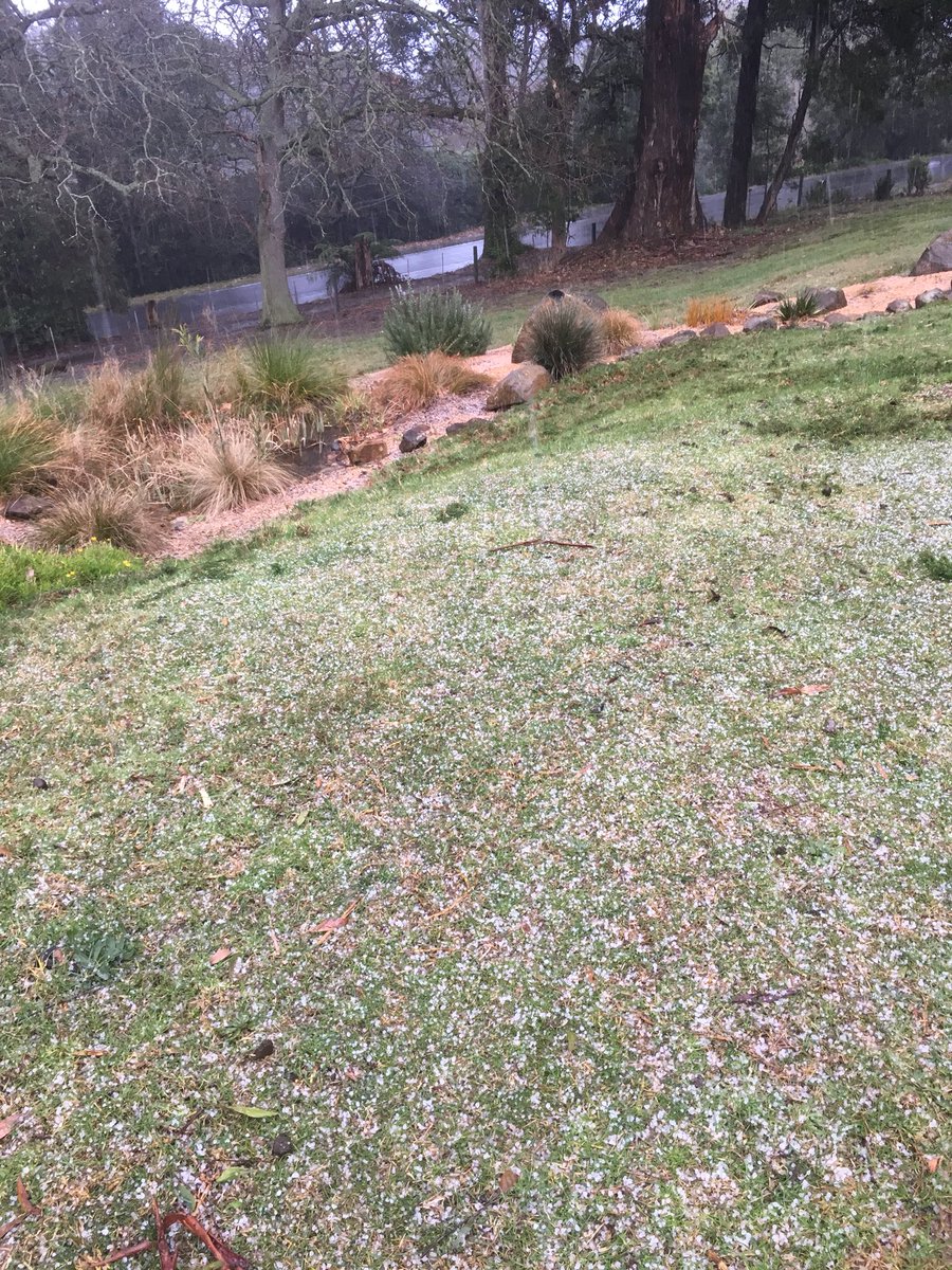
Here’s a photo of hail here earlier. Got a similar cover on about four occasions under different hail showers.
Radar looks ok atm, and scored 18mm here today. Showers quite frequent atm. Tending to think we should get the odd flurry tonight, but it’s pretty marginal with the freezing level dropping to about 850m and 850Ts just touching on -4C.
Here’s a photo of hail here earlier. Got a similar cover on about four occasions under different hail showers.
- Macedonian
- Supercell
- Reactions:
- Posts: 2330
- Joined: Mon Dec 21, 2009 10:44 pm
- Location: Mount Macedon Vic at 870m above sea level
Re: Sequence of fronts: August 3-13
Just had some more snow, quite heavy for a while, everything started to turn white but then it stopped. Grrr. The mountain looks like its splitting the showers on the radar. Frustrating because its down to 1.2C now.
Home- "Shepherd's Bush" at Mt Macedon. 870m
Work- "Bolobek" at Macedon. 430m
Work- "Bolobek" at Macedon. 430m
- stevco123
- Supercell
- Reactions:
- Posts: 2937
- Joined: Sat Aug 07, 2010 7:42 pm
- Location: Cranbourne 78m asl
Re: Sequence of fronts: August 3-13
Otways doing their thing and shredding everything to bits coming this way
https://www.weatherlink.com/bulletin/53 ... 76dd68e8bc: for current weather updated every 2 minutes
- Gordon
- Supercell
- Reactions:
- Posts: 2896
- Joined: Thu Jun 17, 2010 10:01 am
- Location: Near Gordon, Vic. 620 m asl
Re: Sequence of fronts: August 3-13
A couple of pics as promised from a few days ago in the Snowys:
Road near Adaminaby (about 1100m asl)

And roadside drifts about 20km from Cooma (about 1200m asl)

Hope your place looks a bit like this by morning HB.
Road near Adaminaby (about 1100m asl)
And roadside drifts about 20km from Cooma (about 1200m asl)
Hope your place looks a bit like this by morning HB
- Macedonian
- Supercell
- Reactions:
- Posts: 2330
- Joined: Mon Dec 21, 2009 10:44 pm
- Location: Mount Macedon Vic at 870m above sea level
Re: Sequence of fronts: August 3-13
Nice pics Gordon!
Home- "Shepherd's Bush" at Mt Macedon. 870m
Work- "Bolobek" at Macedon. 430m
Work- "Bolobek" at Macedon. 430m
- stevco123
- Supercell
- Reactions:
- Posts: 2937
- Joined: Sat Aug 07, 2010 7:42 pm
- Location: Cranbourne 78m asl
Re: Sequence of fronts: August 3-13
Looking at the radar, you're looking good for some snow cover by morning it seems.
Flow gone more southerly so precipitation should now penetrate through the metro area and beyond
https://www.weatherlink.com/bulletin/53 ... 76dd68e8bc: for current weather updated every 2 minutes
-
hillybilly
- Site Admin/Moderator
- Reactions:
- Posts: 5003
- Joined: Thu Nov 26, 2009 7:26 am
- Location: Howden Tasmania, 25m above sea level
- Contact:
Re: Sequence of fronts: August 3-13
Coldest night for the year here with 1C but no snow. We had a shower about 4am and I woke up but no sign of anything frozen and the precip I did see falling was slight rain. Possible there was a flurry. I did see a little sleet about 6pm and again about 8pm, but nothing I would quite call snow. About 19mm for the last day and a bit so a handy fall. MTD close to 50mm here so running close to average
Warm air advection kicking in now so will get drizzle later today.
These westerlies and frequent fronts go the whole week ahead. Possibility of a strong cold outbreak next weekend
New thread or just extend this one for another week?
Warm air advection kicking in now so will get drizzle later today.
These westerlies and frequent fronts go the whole week ahead. Possibility of a strong cold outbreak next weekend
New thread or just extend this one for another week?