Let's see if I can break the curse! Ridiculous differences for this period in the models over the last week, but now that the system is starting to show on WATL 4 days out, maybe it's got something after all?
EC has us down for about 60mm (after having 0.5mm three days ago!). GFS about 20mm after bidding as high as 75mm. ACCESS has remained keen throughout (it will get my gold star if this comes off). WATL going for 25-50mm for a fair bit of VIc.
GFS is remaining somewhat conservative at present. 12Z EC was spectacular (100mm+), and the 00Z run will be interesting. Either way, the warm weather will come to a grinding halt in a couple of days....
Not just us who are uncertain what this system will bring... 4.32pm and BOM is yet to issue it's brief towns forecasts (due 4.05pm) or district forecasts (due 4.15pm), never mind the long versions.
I think this event has 2 parts at least
The 2nd part is more interesting at the trough taps into a Huge amount of tropical moisture from Central Australia and streams into northwest Victoria during Monday and Southern Vic Tuesday
Mike wrote: ↑Thu Mar 18, 2021 7:25 pm
EC has continued with its eastward trend, each of the last few runs it moved a little east.
At this rate by Saturday it will be progging rain in NZ from this system
EC also has a more northern focus on its latest run, but it will likely change again. Meanwhile, GFS extends rain to the west and ACCESS has decent rain over almost all of Vic. There’s clearly still some uncertainty, but not surprising even a few days out with these kinds of set-ups where minor changes in the positioning of the upper low and associated troughs makes a huge difference. Would be great if it comes off, but I suspect this one will go down to the wire with the models.
Thick fog here this morning, which hung around until the late morning. A sign of the moisture coming in from the east.
Really noticing the shorter days and weaker sun now. Leaves are also slowly switching to their autumn colours - love this time of year.
Bit worried when EC went off last night, but is back on with the 12Z run. Remarkable consistency across the progs with most areas showing 20-80mm for the sequence, tending to be lightest on the southwest coast. Heaviest falls tending to focus on the northern slopes. EC now forming quite an intense low in the trough that tacks southeast across Victoria so could see a wrap around into central and eastern areas.
Timing is a bit unclear, but broadly rain and storms spread south on Sunday, and should be in Melbourne late on the weekend. Widespread rain Monday clearing slowly on Tuesday and Wednesday. Great event if that all happens.
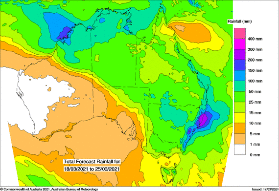
Further northern NSW in from a deluge. Progs showing that locally could top 200 to 500mm
GFS remains stubborn against all other models again today. It moves a LLC early next week down from Swan Hill over Melb to Tassie, the rest seem keen on a Corowa-Bairnsdale track. Time will tell. No matter what, its rain at the right time for a large region of Vic.
Models still holding, but timing and how far south and west the heavy falls extend is still a bit unclear. What’s clear is north central looks to be in the direct path with heavy falls spilling south through Sunday.
Looks like central starts to get showers and possible storms later Sunday and then rain slowly clears east as a low forms near the Gippsland Coast and southern NSW coast around Tuesday.
Torrential rain to the north. All the major models showing huge falls through western parts of Sydney and much of the coastal strip. EC suggesting multi day totals could well pass 400mm TBH this looks very damaging. Would not be surprised if this leaves a very bad flood situation up there, with a lot of flooding already and so much more on the forecasts
The last few model runs (GFS in particular) have been pushing the rain more out East. A smell a fizzer coming, especially for Western Vic/Mallee. ICON and EC still look good for 40mm+, but none of the 60mm+ silliness anymore.
its been a never ending pattern of "cry wolf" groundhog day with the weather for many months, to be honest I can't see that pattern changing or why I should take any notice of it this time around.
This weather event is still pretty hard to tell if it will affect Melbourne badly or not. I guess we'll have to wait and see. I somewhat feel NSW is sucking majority of the moisture out of it.
GFS has gone rogue, upgrades when the other models downgrade and jumps off when they all jump on. Its a rebel without a clue (or not) , most models seemed to have upgraded from the point of view of totals and westward extent of decent rain on the 00z run (GFS the opposite). Time will tell, great satellite and good to see all those sparks in SA in the last hour or so as well.