
Welcome New Members! We want to hear from you. Register, stop lurking and start posting!
Becoming windy with a strong change: May 7-11
Re: Becoming windy with a strong change: May 7-11
Worrying storm surge there indeed. 6c and frequent wet hail with showers here this evening.
-
hillybilly

- Site Admin/Moderator
- Reactions:
- Posts: 4979
- Joined: Thu Nov 26, 2009 7:26 am
- Location: Howden Tasmania, 25m above sea level
- Contact:
Re: Becoming windy with a strong change: May 7-11
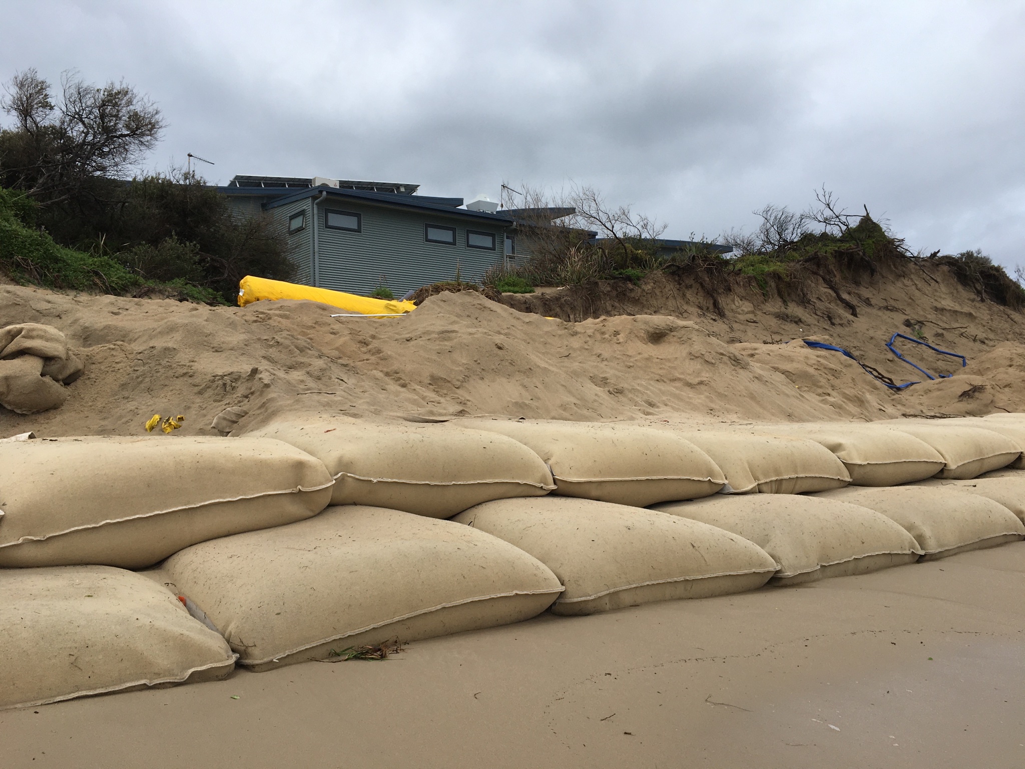
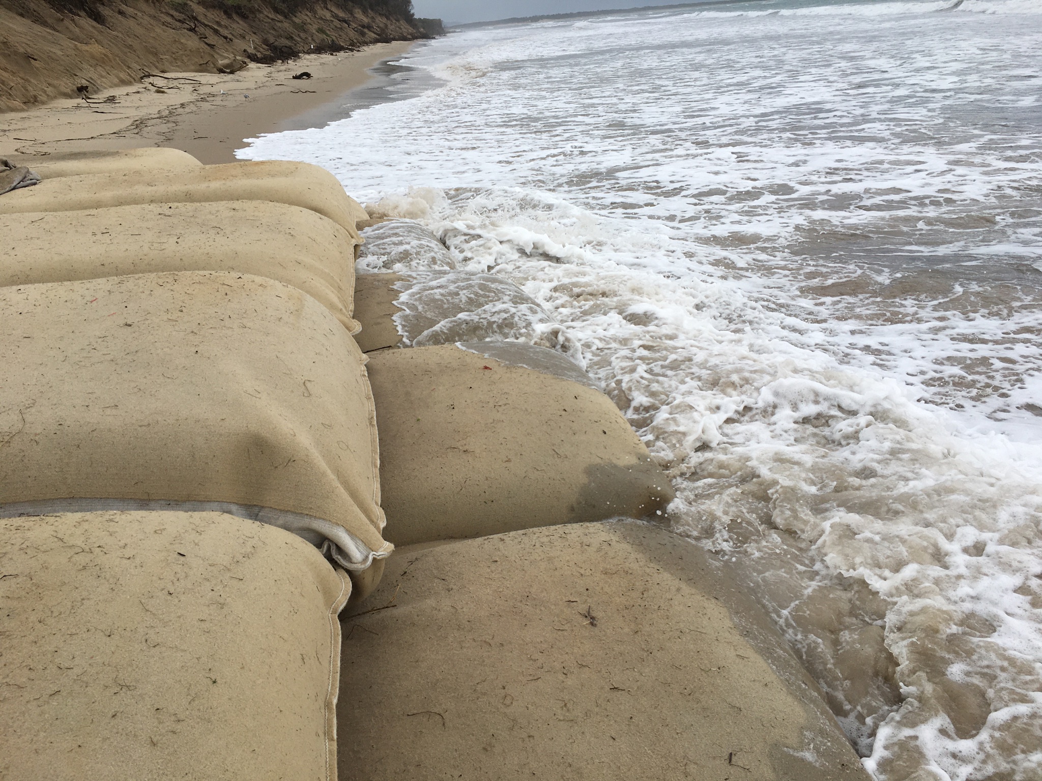
Just wait to you see the photos from Inverloch Beach. Will put them up later. These events are getting more frequent and worse. I could not believe how high the water was today. It wasn’t a particularly deep low, but timed on one of the highest tides and that trend just keeps going one way. Imagine what that looks like with another 10-20cm which is what it would have been with a pressure of 990hPa.
You can see the water is calm (flowing inland) and clear with no evidence of flood waters.
Had a couple of booming rumbles this evening. Big band of coldies just north of us.
-
hillybilly
- Site Admin/Moderator
- Reactions:
- Posts: 4979
- Joined: Thu Nov 26, 2009 7:26 am
- Location: Howden Tasmania, 25m above sea level
- Contact:
Re: Becoming windy with a strong change: May 7-11
Cold one in the Nongs this morning with a min of 2C. Almost snow weather 
At Walkerville about 5C. 19mm in the gauge. Got one torrrential coldie during the night with a barrage of hail. Nothing more in the gauge in FC so still on 12mm.
Here are some photos of the storm surge at Inverloch.
First from the local paper (the road is closed west bound now).

And shots I took on my beach walk.
At Walkerville about 5C. 19mm in the gauge. Got one torrrential coldie during the night with a barrage of hail. Nothing more in the gauge in FC so still on 12mm.
Here are some photos of the storm surge at Inverloch.
First from the local paper (the road is closed west bound now).
And shots I took on my beach walk.
- Gordon
- Supercell
- Reactions:
- Posts: 2888
- Joined: Thu Jun 17, 2010 10:01 am
- Location: Near Gordon, Vic. 620 m asl
Re: Becoming windy with a strong change: May 7-11
Wow! I know both those areas well - the Tarwin 'flood' probably won't do any major damage, but the Inverloch foreshore is going to be seriously rearranged  .
.
Another 4.5mm to 9am today, so 11.5mm all up. Very cold night, fluctuating between 1.5-3C. Probably some late night snow flurries in the moonlight!
Another 4.5mm to 9am today, so 11.5mm all up. Very cold night, fluctuating between 1.5-3C. Probably some late night snow flurries in the moonlight!
- StratoBendigo
- Supercell
- Reactions:
- Posts: 2809
- Joined: Fri Jan 02, 2015 2:18 pm
- Location: Kangaroo Flat
Re: Becoming windy with a strong change: May 7-11
6mm yesterday and a light frost this morning. Feels like mid-winter.
- Macedonian
- Supercell
- Reactions:
- Posts: 2330
- Joined: Mon Dec 21, 2009 10:44 pm
- Location: Mount Macedon Vic at 870m above sea level
Re: Becoming windy with a strong change: May 7-11
We had some good snow showers last night around 7pm. Min temp was 0.7C and a cold breezy 5C now.
Home- "Shepherd's Bush" at Mt Macedon. 870m
Work- "Bolobek" at Macedon. 430m
Work- "Bolobek" at Macedon. 430m
-
hillybilly
- Site Admin/Moderator
- Reactions:
- Posts: 4979
- Joined: Thu Nov 26, 2009 7:26 am
- Location: Howden Tasmania, 25m above sea level
- Contact:
Re: Becoming windy with a strong change: May 7-11
It’s getting crazy on the coast. This isn’t an isolated event, though some places are doing worse. I saw some photos from Sandy Point the other day which showed the water broke though in multiple locations to Shallow Inlet.
We actually dodged what could have been a really nasty outcome. Today’s tide at Inverloch is about 15cm higher, but the storm surge is less. Another 10-20cm or water on those waves and it would have got even nastier. Driving through Tarwin today, was clear the water had got about 5cm higher than in my photos looking at bark and grass lines. Down this morning despite heavy rain there overnight, and not much in the paddocks so reinforces it was the storm surge coming into the estuary.
- QldTwister
- Cumulonimbus
- Reactions:
- Posts: 432
- Joined: Tue May 22, 2012 7:56 pm
- Location: Ashwood Vic
Re: Becoming windy with a strong change: May 7-11
Nice pics there that road will be gone in a few years with many more big winter stroms and fronts to come
11mm here from the front over the weekend.
On this mornings walk everything is so green, but all the parks and ovals are so wet and muddy with water laying around everywhere things are def saturated out there and going to be a big old mud pits come end of winter.
Few weak fronts over the next 7 to 10 days but generally quite, think things will pick up come June and go really big Aug to Dec
Couple of nice sunny days coming up to so thats always nice this time of year.
Bring on the heat and stroms
-
hillybilly
- Site Admin/Moderator
- Reactions:
- Posts: 4979
- Joined: Thu Nov 26, 2009 7:26 am
- Location: Howden Tasmania, 25m above sea level
- Contact:
Re: Becoming windy with a strong change: May 7-11
Chilly one here in the Nongs with max of just 8.8C. Few showers, but just 0.4mm in the gauge.
Nice Monday coming up, with another front approaching later on Tuesday. Quite a chilly system again, though not a big rain producers.
Nice Monday coming up, with another front approaching later on Tuesday. Quite a chilly system again, though not a big rain producers.
-
Didjman

- Supercell
- Reactions:
- Posts: 2099
- Joined: Fri Sep 03, 2010 2:52 pm
- Location: Wallan, Vic 328m ASL
- Contact:
Re: Becoming windy with a strong change: May 7-11
Hoping for a cracker of a storm season with no fires!QldTwister wrote: ↑Sun May 10, 2020 5:39 pm think things will pick up come June and go really big Aug to Dec
-
hillybilly
- Site Admin/Moderator
- Reactions:
- Posts: 4979
- Joined: Thu Nov 26, 2009 7:26 am
- Location: Howden Tasmania, 25m above sea level
- Contact:
Re: Becoming windy with a strong change: May 7-11
Another quiet autumn day. Mix of cloud and sun.
Front for tomorrow with some showers, mostly in south. Looks like the next proper system is about ten days out.
Front for tomorrow with some showers, mostly in south. Looks like the next proper system is about ten days out.
- StratoBendigo
- Supercell
- Reactions:
- Posts: 2809
- Joined: Fri Jan 02, 2015 2:18 pm
- Location: Kangaroo Flat
Re: Becoming windy with a strong change: May 7-11
Yep, cold and mostly dry for a while, and there are some indications of a conveyor belt of tropical moisture later this month.

-
hillybilly
- Site Admin/Moderator
- Reactions:
- Posts: 4979
- Joined: Thu Nov 26, 2009 7:26 am
- Location: Howden Tasmania, 25m above sea level
- Contact:
Re: Becoming windy with a strong change: May 7-11
Max of 9.9C here under a cloudy sky with a biting wind. Quite unpleasant out to be honest. Front pushing through tonight. Maybe 10mm locally, but most will mainly see dribbles. Long mild for May spell to follow. Maybe some proper weather again in about ten days.
-
hillybilly
- Site Admin/Moderator
- Reactions:
- Posts: 4979
- Joined: Thu Nov 26, 2009 7:26 am
- Location: Howden Tasmania, 25m above sea level
- Contact:
Re: Becoming windy with a strong change: May 7-11
Stuck between a slow moving area of rain to our north and another to our south. 1mm in the gauge. Doesn’t look too impressive atm. Dull day coming up with with rain slowly clearing.
Looks like a long mild and dry spell ahead. Could even see temps pop into the low to mid 20s next week on the flats before something in about ten days.
Looks like a long mild and dry spell ahead. Could even see temps pop into the low to mid 20s next week on the flats before something in about ten days.
-
hillybilly
- Site Admin/Moderator
- Reactions:
- Posts: 4979
- Joined: Thu Nov 26, 2009 7:26 am
- Location: Howden Tasmania, 25m above sea level
- Contact:
Re: Becoming windy with a strong change: May 7-11
Turning into a rainy and foggy morning. Just on 5mm in the gauge so far. Bit more to come going by the radar.
A couple of photos from the dogless morning walk (the dog refused to get off the couch ).

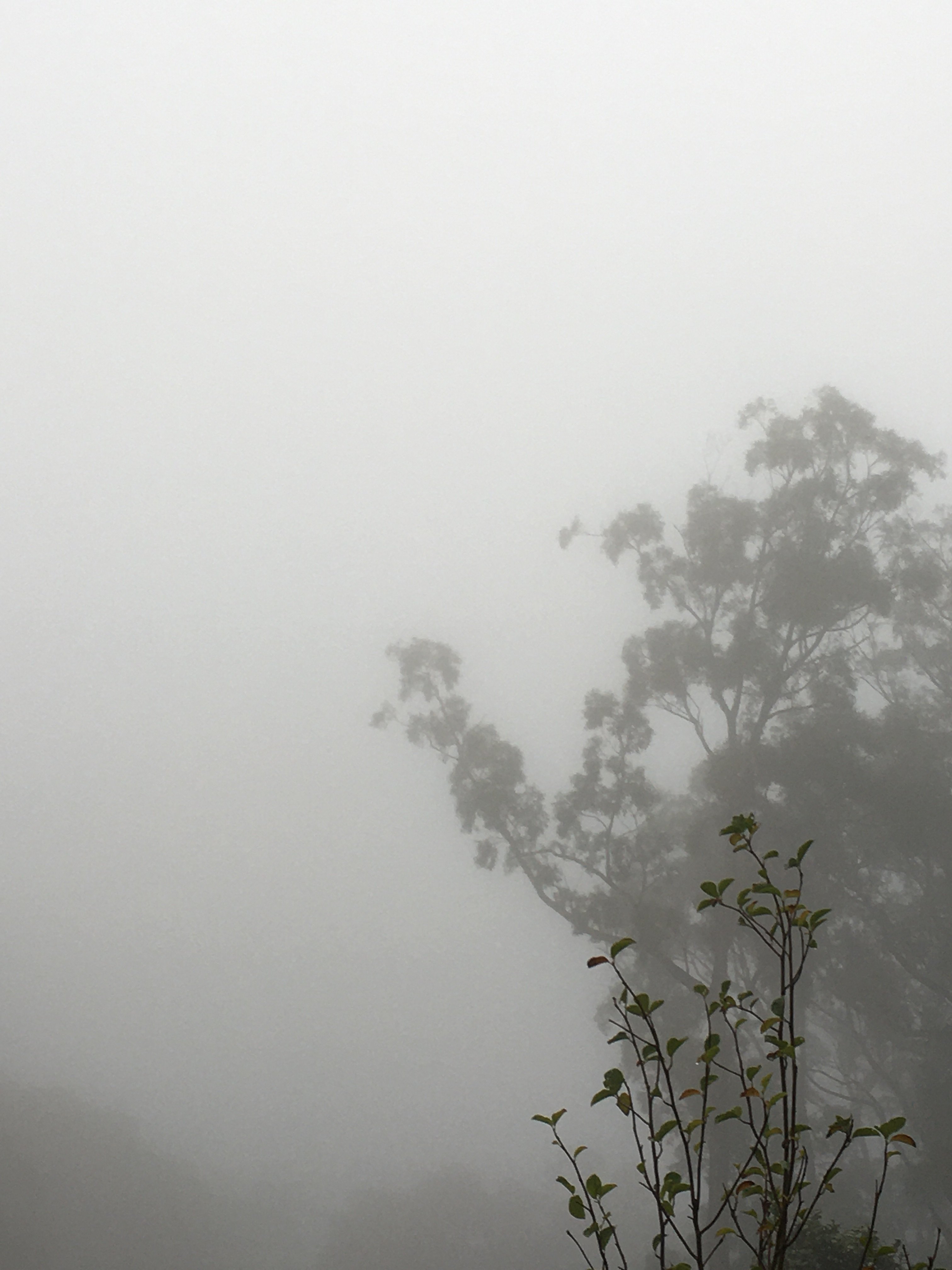
A couple of photos from the dogless morning walk (the dog refused to get off the couch
- StratoBendigo
- Supercell
- Reactions:
- Posts: 2809
- Joined: Fri Jan 02, 2015 2:18 pm
- Location: Kangaroo Flat
Re: Becoming windy with a strong change: May 7-11
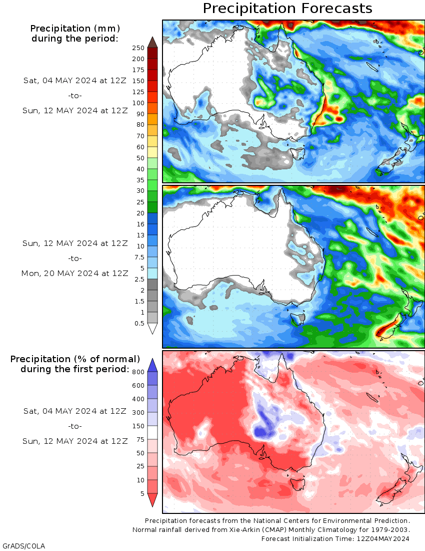
Early indications of a significant deluge in much of Eastern Australia around May 22-25 is appearing in the GFS forecast charts. That'll get the rivers flowing hard if it comes off.
- QldTwister
- Cumulonimbus
- Reactions:
- Posts: 432
- Joined: Tue May 22, 2012 7:56 pm
- Location: Ashwood Vic
Re: Becoming windy with a strong change: May 7-11
5mm today with front
Nice cool to mild and SUNNY week coming up happy about that
Yeah GFS has had that epic cut off for days and days now with widespread heavy rain it would be the pefect start to winter for cropping areas
BUT EC and ACCESS have nothing and havent for days just High pressure and maybe strong front and cold outbreak for the SE hope they flip soon
PRAYING GFS comes off 5 days now every run it has had it heres hoping
Bring on the heat and stroms
-
hillybilly
- Site Admin/Moderator
- Reactions:
- Posts: 4979
- Joined: Thu Nov 26, 2009 7:26 am
- Location: Howden Tasmania, 25m above sea level
- Contact:
Re: Becoming windy with a strong change: May 7-11
Finished just shy of 7mm in the end. Chilly max of 8.6C. Now a long dry and mild spell. Need to stack some fire wood, so Saturday is sorted 
MTD is about 60mm in the Nongs so tracking on about average, while Walkerville is on about 100mm so off to a good start. Not expecting anything now til about this time next week.
MTD is about 60mm in the Nongs so tracking on about average, while Walkerville is on about 100mm so off to a good start. Not expecting anything now til about this time next week.
- snowfall
- Supercell
- Reactions:
- Posts: 1283
- Joined: Mon Mar 20, 2017 7:39 pm
- Location: Gisborne South (349m asl)
Re: Becoming windy with a strong change: May 7-11
5.4mm here today and a max of 11.9c. Currently 6.9c, so a fairly chilly evening considering the cloud cover.
Not much rain again for a while. We’re only on 22mm for the month so far, so we may need a fairly big rain event later in the month to catch-up with the average. Hopefully GFS is right with it’s current projections!
Not much rain again for a while. We’re only on 22mm for the month so far, so we may need a fairly big rain event later in the month to catch-up with the average. Hopefully GFS is right with it’s current projections!