Second hottest summer on record for Australia. Would have been hottest, but 2018/19 was extraordinary hot, and thankfully we didn’t beat it. Melbourne was a bit above average, due to a very hot December, and very mild nights with all the humidity. Yet to see numbers for Vic, but expect it to be a bit above average. It was about the weirdest summer I’ve seen in the Nong, cold early, then stinking hot (about 4 weeks), then humid and smoky (2 weeks), then very humid and wet (6 weeks). It each of the periods it barely bucked the trend and stays stuck.
This is not the place to discuss climate change, btw.

Welcome New Members! We want to hear from you. Register, stop lurking and start posting!
1-7 March: Cold front then ex TC or trough?
-
hillybilly

- Site Admin/Moderator
- Reactions:
- Posts: 4980
- Joined: Thu Nov 26, 2009 7:26 am
- Location: Howden Tasmania, 25m above sea level
- Contact:
-
hillybilly
- Site Admin/Moderator
- Reactions:
- Posts: 4980
- Joined: Thu Nov 26, 2009 7:26 am
- Location: Howden Tasmania, 25m above sea level
- Contact:
Re: 1-7 March: Cold front then ex TC or trough?
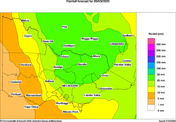
Struggling to keep up with the progs with a really complex set up. Next 24 hours is easy. Beaut day today, but change approaching late. Solid front tomorrow early with widespread showers and perhaps the odd rumble, mainly south and ranges. Locally up to 15mm. Could just about see a flurry around Baw Baw and Lake Mt.
Then deep upper trough builds through Tuesday and Wednesday dragging down tropical moisture. Looks like a low will develop near Victoria late Wednesday and Thursday. This isn’t the ex-TC, but it does tap the moisture. Heavy falls in the east and probably central areas. Boundary looks a bit unclear, but EC, CMC and UK currently put good falls as far west as west central and the Wimmera. Could be very heavy around the northeast slopes Not confident on details, but currently looks like 20-50mm central, and 50mm plus for east. More like 5-20mm western areas.
Then deep upper trough builds through Tuesday and Wednesday dragging down tropical moisture. Looks like a low will develop near Victoria late Wednesday and Thursday. This isn’t the ex-TC, but it does tap the moisture. Heavy falls in the east and probably central areas. Boundary looks a bit unclear, but EC, CMC and UK currently put good falls as far west as west central and the Wimmera. Could be very heavy around the northeast slopes
- StratoBendigo
- Supercell
- Reactions:
- Posts: 2809
- Joined: Fri Jan 02, 2015 2:18 pm
- Location: Kangaroo Flat
Re: 1-7 March: Cold front then ex TC or trough?
Certainly an upgrade overnight for us. We're still "on-the-edge" of the system this Thursday-Friday.
Re: 1-7 March: Cold front then ex TC or trough?
I am currently camping up past Albury on Lake Hume, I’ve never seen the lake so low!! 16% capacity... The hills have a tinge of green due to recent thunderstorms but the area around Benalla and Wangaratta is incredibly dry 

- snowfall
- Supercell
- Reactions:
- Posts: 1284
- Joined: Mon Mar 20, 2017 7:39 pm
- Location: Gisborne South (349m asl)
Re: 1-7 March: Cold front then ex TC or trough?
Yes there's still a bit of uncertainty in the models, especially for central areas, although they've been consistently showing good falls in the north-east and across the border for a large part of NSW. Hopefully it will become clearer by tomorrow and point to something decent in central areas.
Really enjoyed the summer this year, apart from the wretched heat and dry of December. And it's good to see we overturned the pattern of the previous two summers that had a wet December but transitioned into a flash drought for the rest of the season.
We've landed well below average for temps in February:
Average maximum was 22.3c (about 3 degrees below the long-term average)
Average minimum was 12.1c (about half a degree below the long-term average)
Overall average temperature was 16.5c.
Had 72mm of rain, which is comfortably above average.
Had 11 days where the maximum temperature was in the teens and only two days above 30 (both 31c).
Coldest maximum was 15.4c recorded on the 3rd and the 20th.
Coldest morning was 5.9c on the 27th.
It sure was humid - average humidity for the month was 82.9%.
YTD rainfall is currently 219m. The summer total came in at 228mm.
If only every Feb could be wet, humid, and mild!
- Dane
- Supercell
- Reactions:
- Posts: 1661
- Joined: Thu Nov 26, 2009 9:51 am
- Location: Sebastopol 420m ASL
- Contact:
Re: 1-7 March: Cold front then ex TC or trough?
February was slightly wetter than normal here.
45.6mm's at the Airport - Ave is 43.4mm's.
Did considerably better here in Sebastopol with 68.8mm's.
Over the Summer slightly below average with 127.9mm's in Sebastopol and 121.0mm's at the airport.
Summer average is 132.9mm's.
February daytime temps were 1.7c below average at the Airport. Night time mins were 1.0c above average.
Only 1 day above 30c at the Airport I had 2 - average is 7.
Started of Autumn with a 30 plus though 31.3c at the Airport I had 30.7c
Looks like a few mm's overnight and early tomorrow with that front.
System later in the week not sure of, we may be too far West to get much from it.
- StratoBendigo
- Supercell
- Reactions:
- Posts: 2809
- Joined: Fri Jan 02, 2015 2:18 pm
- Location: Kangaroo Flat
Re: 1-7 March: Cold front then ex TC or trough?
00Z EC - Wow!
Re: 1-7 March: Cold front then ex TC or trough?
EC where I look went away from it for us, can you put up a link?
thank you
thank you
-
hillybilly
- Site Admin/Moderator
- Reactions:
- Posts: 4980
- Joined: Thu Nov 26, 2009 7:26 am
- Location: Howden Tasmania, 25m above sea level
- Contact:
Re: 1-7 March: Cold front then ex TC or trough?
Spend an awesome day in the Peninsula under a warm humid sun. Surprised how warm the water at Flinders was. It touched 26C here up in the Nongs but heading down now. Should pick up 5-10mm overnight.
EC, GFS and CMC showing big upgrades. EC is type forecast with the tropical low diving south and bombing in Bass Strait. Looks really nasty for 36 hours.
EC, GFS and CMC showing big upgrades. EC is
- Gordon
- Supercell
- Reactions:
- Posts: 2888
- Joined: Thu Jun 17, 2010 10:01 am
- Location: Near Gordon, Vic. 620 m asl
Re: 1-7 March: Cold front then ex TC or trough?
WATL (average of most models) at 8pm this evening looks interesting for Thursday.
Still not sure what to expect on what days, but at least the trend to push most of the rain east out through NSW and into the Tasman, seems to have reversed.
Still not sure what to expect on what days, but at least the trend to push most of the rain east out through NSW and into the Tasman, seems to have reversed.
- Tassiedave
- Supercell
- Reactions:
- Posts: 1098
- Joined: Thu Nov 11, 2010 11:09 am
- Location: Grindelwald Tasmania
Re: 1-7 March: Cold front then ex TC or trough?
Tas rainfall: Mount Read 30mm, Mt Barrow 28mm, Tea Tree 26mm, Nunamara 21mm, Meander 21mm, Hobart 17mm, Launceston 14mm
- StratoBendigo
- Supercell
- Reactions:
- Posts: 2809
- Joined: Fri Jan 02, 2015 2:18 pm
- Location: Kangaroo Flat
Re: 1-7 March: Cold front then ex TC or trough?
This morning's forecast models have wobbled back East. On the edge of nothing or 80mm.
I'm back to watering the plants again...
I'm back to watering the plants again...
-
hillybilly
- Site Admin/Moderator
- Reactions:
- Posts: 4980
- Joined: Thu Nov 26, 2009 7:26 am
- Location: Howden Tasmania, 25m above sea level
- Contact:
Re: 1-7 March: Cold front then ex TC or trough?
Welcome 10mm overnight for us getting autumn off to a start. Was cold, wet, windy and foggy when I got up this morning - about the opposite weather to Sunday 
Progs continue to wiggle. Shifting more northeast overnight. Boundary for heavy rain/light rain sits somewhere within about 100km of a line from Bendigo to about Melbourne. Could get 10mm or 100mm in Ferny Creek based on the scenarios being thrown up.
These systems tend to land in the middle of the model range, so should see 20-50mm, but not entirely confident.
- Wilko
- Supercell
- Reactions:
- Posts: 1492
- Joined: Wed Aug 11, 2010 12:08 pm
- Location: Moorabbin & Highett, Vic
Re: 1-7 March: Cold front then ex TC or trough?
I really hope the updates shift the rain more westward
It would be a real shame if it drifted into coastal NSW
The BOM 4 day charts look ok but the devil is in the detail
Updated EC will be. Interesting
Very complex with the positioning of the surface trough and low from. Ex tropical cyclone
It would be a real shame if it drifted into coastal NSW
The BOM 4 day charts look ok but the devil is in the detail
Updated EC will be. Interesting
Very complex with the positioning of the surface trough and low from. Ex tropical cyclone
- Sean
- Supercell
- Reactions:
- Posts: 1000
- Joined: Mon Feb 27, 2012 6:35 pm
- Location: Patterson Lakes - SE Melb
Re: 1-7 March: Cold front then ex TC or trough?
Metro still on the edge. Thursday morning is tipped to see the bulk of what does fall.
Would like to see it edge west, as we'd probably see our monthly average in a single day, but it wants to favour the NE, as it's been creeping that way on the charts for days now.
Would like to see it edge west, as we'd probably see our monthly average in a single day, but it wants to favour the NE, as it's been creeping that way on the charts for days now.
- stevco123
- Supercell
- Reactions:
- Posts: 2936
- Joined: Sat Aug 07, 2010 7:42 pm
- Location: Cranbourne 78m asl
Re: 1-7 March: Cold front then ex TC or trough?
I'm telling ya, these things always end up between Sydney and Mallacoota, at some unheard of place. That was my prediction last week and it's looking that way, so I'm sticking to it (reverse psychology start now...)Sean wrote: ↑Mon Mar 02, 2020 8:43 pm Metro still on the edge. Thursday morning is tipped to see the bulk of what does fall.
Would like to see it edge west, as we'd probably see our monthly average in a single day, but it wants to favour the NE, as it's been creeping that way on the charts for days now.
https://www.weatherlink.com/bulletin/53 ... 76dd68e8bc: for current weather updated every 2 minutes
-
hillybilly
- Site Admin/Moderator
- Reactions:
- Posts: 4980
- Joined: Thu Nov 26, 2009 7:26 am
- Location: Howden Tasmania, 25m above sea level
- Contact:
Re: 1-7 March: Cold front then ex TC or trough?
All moving southwest on the progs again. UK moved a good 200km, while other models more like 100km. North central and central now on the edge or within the area of heavy falls. Northeast looks big. Progs pretty consistent in putting falls around 200mm in the foothills of the alps. With local variations due to favourable topography, convection etc you would tend to expect some spots could see double that.
- StratoBendigo
- Supercell
- Reactions:
- Posts: 2809
- Joined: Fri Jan 02, 2015 2:18 pm
- Location: Kangaroo Flat
Re: 1-7 March: Cold front then ex TC or trough?
Yes, EC for the win. Still anything from 2 to 100mm is possible.
- Dane
- Supercell
- Reactions:
- Posts: 1661
- Joined: Thu Nov 26, 2009 9:51 am
- Location: Sebastopol 420m ASL
- Contact:
Re: 1-7 March: Cold front then ex TC or trough?
Too far west here in Ballarat to get much from this system it seems.
BOM going for 2 to 12mm's here over the next 3 days.
BOM going for 2 to 12mm's here over the next 3 days.
-
hillybilly
- Site Admin/Moderator
- Reactions:
- Posts: 4980
- Joined: Thu Nov 26, 2009 7:26 am
- Location: Howden Tasmania, 25m above sea level
- Contact:
Re: 1-7 March: Cold front then ex TC or trough?
Melbourne to Bendigo seems to be the line dividing light falls and heavy falls, but could fall 100km either side. Could get 5 or 50mm here. Dangerous rainfall amounts showing up for the northeast with progs topping out around 200 to 300mm. Those falls are grid cell averages, so spot fall could easily go 50 to 100mm above that. I’m not sure I’ve seen such high falls before for a ~36 hour period in Vic