Welcome New Members! We want to hear from you. Register, stop lurking and start posting!

VIC - Warming trend with dangerous fire WX followed by rain - 27 Jan - 3 Feb 2020

Archived topics from the General Weather Discussion board.
S
Sean
Supercell
Reactions:
Posts: 1000
Joined: Mon Feb 27, 2012 6:35 pm
Location: Patterson Lakes - SE Melb

Re: VIC - Warming trend with dangerous fire WX - 27 - 31 Jan 2020

Post by Sean »

StratoBendigo wrote: Wed Jan 29, 2020 3:48 pm Still a whiff of hope in the GFS forecasts which pushes a fair bit of rain into Vic. I'm not that optimistic though.
I don't blame you! :)

I'm still fairly optimistic at this stage however. The synoptics are holding and there's still a lot of moisture persisting over QLD and NT
User avatar
hillybilly
Site Admin/Moderator
Reactions:
Posts: 4978
Joined: Thu Nov 26, 2009 7:26 am
Location: Howden Tasmania, 25m above sea level
Contact:

Re: VIC - Warming trend with dangerous fire WX - 27 - 31 Jan 2020

Post by hillybilly »

Max of 26C here today so starting to warm up. Hot tomorrow, hotter Friday.

Humidity is going to be a real feature with dew point raising into the mid teens Friday and locally to the mid 20s Saturday. EC has spot values of 26C which would challenge the Victorian record of ~26C at Geelong on 29 December 2016 (pretty sure that’s the date).

Substantial rain in western areas. Progs also increasing falls into central areas. Hoping for an inch here on the weekend, but could land anywhere between 10 and 50mm.
User avatar
hillybilly
Site Admin/Moderator
Reactions:
Posts: 4978
Joined: Thu Nov 26, 2009 7:26 am
Location: Howden Tasmania, 25m above sea level
Contact:

Re: VIC - Warming trend with dangerous fire WX - 27 - 31 Jan 2020

Post by hillybilly »

Progs upping rainfall. Looking very wet in west and central areas now :D

Hot one today. Already 25C here this morning.
T
Tassiedave
Supercell
Reactions:
Posts: 1098
Joined: Thu Nov 11, 2010 11:09 am
Location: Grindelwald Tasmania

Re: VIC - Warming trend with dangerous fire WX - 27 - 31 Jan 2020

Post by Tassiedave »

At 6 am it is 25 degrees in Hobart!!
s
stevco123
Supercell
Reactions:
Posts: 2936
Joined: Sat Aug 07, 2010 7:42 pm
Location: Cranbourne 78m asl

Re: VIC - Warming trend with dangerous fire WX - 27 - 31 Jan 2020

Post by stevco123 »

Most likely 43 will be forecast for Melbourne tomorrow...
https://www.weatherlink.com/bulletin/53 ... 76dd68e8bc: for current weather updated every 2 minutes
s
stevco123
Supercell
Reactions:
Posts: 2936
Joined: Sat Aug 07, 2010 7:42 pm
Location: Cranbourne 78m asl

Re: VIC - Warming trend with dangerous fire WX - 27 - 31 Jan 2020

Post by stevco123 »

... and there it is. 43
https://www.weatherlink.com/bulletin/53 ... 76dd68e8bc: for current weather updated every 2 minutes
T
Tassiedave
Supercell
Reactions:
Posts: 1098
Joined: Thu Nov 11, 2010 11:09 am
Location: Grindelwald Tasmania

Re: VIC - Warming trend with dangerous fire WX - 27 - 31 Jan 2020

Post by Tassiedave »

Tas temps today: Friendly Beaches 38.5, Fingal 36.5, Hobart 36.2, St Helens 35.8, Cressy 34.5, Launceston 32.5, Devonport 20.6.
Hobart is forecast to be 40 degrees tomorrow. Highest recorded is 41.8 4th January 2013
User avatar
Australis(Shell3155)
Supercell
Reactions:
Posts: 3145
Joined: Mon Nov 30, 2009 8:05 pm
Location: FTG
Contact:

Re: VIC - Warming trend with dangerous fire WX - 27 - 31 Jan 2020

Post by Australis(Shell3155) »

Scoresby Sat
WZ 20 to 40mm
BOM 10 to20mm
Happy either way..
w
wolfcat
Cumulonumbus Calvas
Reactions:
Posts: 562
Joined: Sun Mar 07, 2010 12:14 pm
Location: Bentleigh East
Contact:

Re: VIC - Warming trend with dangerous fire WX - 27 - 31 Jan 2020

Post by wolfcat »

Update forecast for Melbourne tomorrow....

Good news bad news kind of thing...

Good news not 41c in the city.
Bad news 43c in the city

Image
S
StratoBendigo
Supercell
Reactions:
Posts: 2809
Joined: Fri Jan 02, 2015 2:18 pm
Location: Kangaroo Flat

Re: VIC - Warming trend with dangerous fire WX - 27 - 31 Jan 2020

Post by StratoBendigo »

BOM only has 3-5mm on Saturday and 0-4mm on Sunday here.

I'm barracking for GFS to come to fruition - it reckons 30mm....
User avatar
Australis(Shell3155)
Supercell
Reactions:
Posts: 3145
Joined: Mon Nov 30, 2009 8:05 pm
Location: FTG
Contact:

Re: VIC - Warming trend with dangerous fire WX - 27 - 31 Jan 2020

Post by Australis(Shell3155) »

Wipe Friday off the calendar and we all will be happy..
S
Sean
Supercell
Reactions:
Posts: 1000
Joined: Mon Feb 27, 2012 6:35 pm
Location: Patterson Lakes - SE Melb

Re: VIC - Warming trend with dangerous fire WX - 27 - 31 Jan 2020

Post by Sean »

It’s looking more and more interesting by the day.

The dip and front look to link up nicely, with a big reservoir of moisture to infeed. It’s going to be the best rain in a long time for some people.
User avatar
hillybilly
Site Admin/Moderator
Reactions:
Posts: 4978
Joined: Thu Nov 26, 2009 7:26 am
Location: Howden Tasmania, 25m above sea level
Contact:

Re: VIC - Warming trend with dangerous fire WX - 27 - 31 Jan 2020

Post by hillybilly »

34C up here in the Nongs. Currently 30C and not expecting it to get a lot cooler.

Putrid day tomorrow, though thankfully it’s lush green here and wind and humidity aren’t too bad.

Record humidity for Saturday a good chance (so many records nowadays :roll: ). The Melbourne DP record is 24.0C from December 29 2016 (same day Geelong set a record for Vic of 26.0C, and we got those freak rain storms). Rain will enter the state early and storms explode over central and east around middle of the day. Trough is a bit too early for my liking, though still looks like a very thundery change middle of the day with rain to follow into the evening. With the dew points forecasts to be into the mid 20s near the trough, any cells will be dumpers :o
s
snowfall
Supercell
Reactions:
Posts: 1283
Joined: Mon Mar 20, 2017 7:39 pm
Location: Gisborne South (349m asl)

Re: VIC - Warming trend with dangerous fire WX - 27 - 31 Jan 2020

Post by snowfall »

37c here today and currently 31.7c. Very warm night ahead. Not looking forward to tomorrow, but Saturday is looking interesting. Humidity is still on the low side currently, with a 7c DP, but I expect that will change sometime around the morning.
Q
QldTwister
Cumulonimbus
Reactions:
Posts: 432
Joined: Tue May 22, 2012 7:56 pm
Location: Ashwood Vic

Re: VIC - Warming trend with dangerous fire WX - 27 - 31 Jan 2020

Post by QldTwister »

Isnt the Melb DP record from like Feb 5th 2011 or something when the city had 80mm and east burbs over 200mm all from TC Yasi moisture.
Swear the Dp got to like 25.6c or something that day in the city. ?

Watching the Dps rocket from 3 to 5c to 21-24c in N SA today was awesome and in peak heating to strong WAA and moisture transport going on, as rich deep mostiure moves south should be teen Dps in the Nw by mornig and only increase state wide coming 36 hours.

SA is just going to flood, in some spots with lots of 50-100mm falls and some totals over 100mm easy.
SW Vic could also see the 50-80mm totals amazing system shame once again along the murray and gippy will miss out just never ends.

In Mildura atm and everything is by far the dryest i have ever seen, not even stubble in the paddocks just dirt no grass everything stressed if ot dead so sad and everything just COVERED in mud way worst than Melb last week they would kill for 20mm here if not 10mm
Back to back years of 110mm or less when should be almost 300mm

Also once get past Mount Macdeon its just DRY DRY DRY worst than a normal Jan.

Intresting 48 hours ahead
Bring on the heat and stroms
S
Sean
Supercell
Reactions:
Posts: 1000
Joined: Mon Feb 27, 2012 6:35 pm
Location: Patterson Lakes - SE Melb

Re: VIC - Warming trend with dangerous fire WX - 27 - 31 Jan 2020

Post by Sean »

Must be uncomfortable across SA right now! The atmosphere is a warm and sultry soup - and building. It’s hard to believe the monsoon isn’t even official yet given how persistently moist the skies have been lately.

Hopefully things come together and SA cops a good soaking. They’re second only to Strato in terms of deserving a drink :)
User avatar
hillybilly
Site Admin/Moderator
Reactions:
Posts: 4978
Joined: Thu Nov 26, 2009 7:26 am
Location: Howden Tasmania, 25m above sea level
Contact:

Re: VIC - Warming trend with dangerous fire WX - 27 - 31 Jan 2020

Post by hillybilly »

QldTwister wrote: Thu Jan 30, 2020 9:45 pm Isnt the Melb DP record from like Feb 5th 2011 or something when the city had 80mm and east burbs over 200mm all from TC Yasi moisture.
Swear the Dp got to like 25.6c or something that day in the city. ?
That event was very humid, but the record comes from the December 2016 event (see http://www.bom.gov.au/climate/current/s ... /scs59.pdf ). You are probably thinking of precipitable water values which did set a record by a mile during that event, but not dew points.

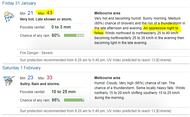
Latest progs have astonishing moisture levels. GFS has values of 60 to 65mm over Melbourne tomorrow morning, and locally over 75mm on northwest Victoria. Will check but think they are the highest humidity values by some margin. In other words in decades of data we’ve never had a tropical moisture infeed as wet as that forecasts for tomorrow. If storms fire, they will be tropical scale dumpers :o I suspect we are going to see Melbourne sample true tropical air tomorrow, with the tropopause a levels usually only seen in the deep tropics. I’ve only seen this once before in the January 2011 event.

GFS, CMC, UK, ACCESS all showing widespread 20-60mm falls apart from eastern of Gippsland and parts of northern Victoria. Given the lumpiness of the rain, would be surprised if we don’t see local spot falls north of the ton :? EC has falls which are patchier - heavy west, but thinning into central areas and not much east. You’d generally back the consensus, but clearly some uncertainty.

Absolute stinker today. Already 28C here at 560m. Looks like quite a lot of thunder through the west, with the odd cell creeping into central areas. This will be Melbourne’s fifth 40C day this “summer”... the average used to be less than one per year :(
G
Gordon
Supercell
Reactions:
Posts: 2887
Joined: Thu Jun 17, 2010 10:01 am
Location: Near Gordon, Vic. 620 m asl

Re: VIC - Warming trend with dangerous fire WX - 27 - 31 Jan 2020

Post by Gordon »

Yesterday was just a 'regular' hot day here, with a slow start building to 35C late afternoon, then a nice cool down to low 20s by 9pm.

Today is already shaping up as a pig of a day though, 26C at 6am and 28C now. I don't know how often we get 28C at 8am at 600m, but it would be very rare. DP still low at 5C so the evaporative cooler is having some effect... but not for long judging by the forecast.

No doubt very handy to have the high humidity coming in to offset fire danger and reduce evaporation, but not great for getting work done!

PS: I've just noticed a first: BOM's Ballarat forecast for Saturday has actually updated this morning, with 'possible heavy falls' added, and rainfall totals going from 15-25mm in yesterday's 4.30pm forecast, to 15-50mm in today's 5.51am forecast. Usually (in fact always until now?), the morning forecast only updates that day's forecast, with the other 6 days identical to the previous 4.30pm forecast. Hope it's a permanent change!
s
snowfall
Supercell
Reactions:
Posts: 1283
Joined: Mon Mar 20, 2017 7:39 pm
Location: Gisborne South (349m asl)

Re: VIC - Warming trend with dangerous fire WX - 27 - 31 Jan 2020

Post by snowfall »

Only got down to 25.2c overnight. That makes it our warmest night of this summer. Currently 31c and DP 9.5c. The wind is also picking up from the NNE.
s
stevco123
Supercell
Reactions:
Posts: 2936
Joined: Sat Aug 07, 2010 7:42 pm
Location: Cranbourne 78m asl

Re: VIC - Warming trend with dangerous fire WX - 27 - 31 Jan 2020

Post by stevco123 »

I looked at the temp at 10 o'clock and it was 30 degrees. Within 20 minutes it shot up to 38 :o
https://www.weatherlink.com/bulletin/53 ... 76dd68e8bc: for current weather updated every 2 minutes
Locked