As an Entrée, I'm issuing a thunderstorm watch for this area

Welcome New Members! We want to hear from you. Register, stop lurking and start posting!
Victoria: Major upper and surface lows - 12–16 Dec 2018
- JasmineStorm
- Supercell
- Reactions:
- Posts: 1870
- Joined: Thu Sep 22, 2016 9:40 pm
- Location: Kyneton 527 ASL
Re: Major upper and surface lows 12–16 Dec
25c and a 17c Dew point here. Longerenong in the Wimmera now has a DP of 21c.
As an Entrée, I'm issuing a thunderstorm watch for this area
As an Entrée, I'm issuing a thunderstorm watch for this area
- Attachments
-
- Storms 1212.jpg (278.26 KiB) Viewed 6709 times
- Jake Smethurst
- Supercell
- Reactions:
- Posts: 3583
- Joined: Mon Nov 23, 2009 8:49 pm
- Location: Cheltenham
Re: Major upper and surface lows 12–16 Dec
The Australian Weather Forum
Thunderstorm Forecast - Day 1
Very unstable atmospheric conditions exist across Victoria today ahead of a trough of low pressure that will extend into the west of the state this afternoon and evening. Isolated thunderstorms are already occurring over parts of the northwest and southwest of the state. Elsewhere, thunderstorms are considered likely during this afternoon and evening as the atmospheric environment becomes more unstable coupled with an increasing moisture profile and the trough moving closer to the state. A focus on activity is likely during the afternoon and evening thanks to maximum surface heating opportunities and also about the west, closest to the trigger point where convective potential can be more fully realised. The eastern ranges may also provide additional forcing for a focus area of development this afternoon. The biggest threat in today's thunderstorms is likely damaging winds and heavy rainfall, although large hail is certainly possible. There is a smaller risk (around 10%) of more organised thunderstorms (i.e. supercells) in the west this afternoon.
- Thunderstorm Forecast Day 1 121218.png (47.23 KiB) Viewed 6695 times
Jake - Senior AWF Forecaster
Feel free to send me a private message if you have any questions.
Feel free to send me a private message if you have any questions.
- Gordon
- Supercell
- Reactions:
- Posts: 2887
- Joined: Thu Jun 17, 2010 10:01 am
- Location: Near Gordon, Vic. 620 m asl
Re: Major upper and surface lows 12–16 Dec
Jake and Jasmine, you're not helping my efforts to focus on work this morning .
.
That strategy has worked very well for Stratobendigo the last two events
- Skywalker
- Supercell
- Reactions:
- Posts: 1871
- Joined: Sun Nov 29, 2009 10:03 am
- Location: Burnside Heights/Cowes (Home) & Sunshine West (Work)
Re: Major upper and surface lows 12–16 Dec
Fingers crossed hey Gordon.
Caroline Springs, Melbourne's meteorological boredom zone.
- Jake Smethurst
- Supercell
- Reactions:
- Posts: 3583
- Joined: Mon Nov 23, 2009 8:49 pm
- Location: Cheltenham
Re: Major upper and surface lows 12–16 Dec
I'm not sure how I'm going to focus for my 1pm-9pm shift either
By the way, here is the 12z EC rainfall scenario from 12am Thursday to 11:59pm Thursday, indicates rain beginning morning hours before increasing late morning, click on the link below to view.
https://twitter.com/AusWeatherForum/sta ... 6144808960
Jake - Senior AWF Forecaster
Feel free to send me a private message if you have any questions.
Feel free to send me a private message if you have any questions.
- Gordon
- Supercell
- Reactions:
- Posts: 2887
- Joined: Thu Jun 17, 2010 10:01 am
- Location: Near Gordon, Vic. 620 m asl
Re: Major upper and surface lows 12–16 Dec
Interesting animation Jake!
And BOM have just posted a SWW:
Severe Weather Warning
for HEAVY RAINFALL
For people in Central, South West, Northern Country, North Central, North East and parts of Mallee, West and South Gippsland and Wimmera Forecast Districts.
Issued at 11:27 am Wednesday, 12 December 2018.
Heavy rainfall and thunderstorms developing Thursday morning - flash flooding may result.
Edit: Now joined by a Flood Watch for or Greater Melbourne, Goulburn, Barwon and parts of West Gippsland.
Last edited by Gordon on Wed Dec 12, 2018 12:22 pm, edited 1 time in total.
- Skywalker
- Supercell
- Reactions:
- Posts: 1871
- Joined: Sun Nov 29, 2009 10:03 am
- Location: Burnside Heights/Cowes (Home) & Sunshine West (Work)
Re: Major upper and surface lows 12–16 Dec
Looks like some development might be starting to take place looking out my south west facing window here at work.
Caroline Springs, Melbourne's meteorological boredom zone.
-
Didjman

- Supercell
- Reactions:
- Posts: 2099
- Joined: Fri Sep 03, 2010 2:52 pm
- Location: Wallan, Vic 328m ASL
- Contact:
Re: Major upper and surface lows 12–16 Dec
CirroCu and gravity waves over tulla - bring it on!!
Re: Major upper and surface lows 12–16 Dec
Storms are building up in the Wimmera with a few sparks around Nhill.
- Luken
- Cumulus
- Reactions:
- Posts: 92
- Joined: Thu Nov 26, 2009 7:35 am
- Location: Belgrave South, 250m ASL
Re: Major upper and surface lows 12–16 Dec
Hi all, looking forward to the next few days, looks like a ripper!
In case you haven't seen this - https://mthotham.panomax.com/#
Great view the high plains and toward Feathertop. Scoll back a few shots to see a nice storm blowing through there ATM.
In case you haven't seen this - https://mthotham.panomax.com/#
Great view the high plains and toward Feathertop. Scoll back a few shots to see a nice storm blowing through there ATM.
-
Didjman
- Supercell
- Reactions:
- Posts: 2099
- Joined: Fri Sep 03, 2010 2:52 pm
- Location: Wallan, Vic 328m ASL
- Contact:
Re: Major upper and surface lows 12–16 Dec
From the live tracker, those storms out west appear to be pulsing.
- JasmineStorm
- Supercell
- Reactions:
- Posts: 1870
- Joined: Thu Sep 22, 2016 9:40 pm
- Location: Kyneton 527 ASL
Re: Major upper and surface lows 12–16 Dec
BoM have just had their big press conference about TC Owen and Hell's mouth from the south. Media headlines are lighting up
A few cells across the state ticking along nicely.
TC Owen now Cat 2 and has dropped 13 hPa in 12 hours.
A few cells across the state ticking along nicely.
TC Owen now Cat 2 and has dropped 13 hPa in 12 hours.
- stevco123
- Supercell
- Reactions:
- Posts: 2936
- Joined: Sat Aug 07, 2010 7:42 pm
- Location: Cranbourne 78m asl
Re: Major upper and surface lows 12–16 Dec
This is definitely a huge event for the eastern half of Australia. Ofcourse it will be hit and miss as to who gets the most severe rain, but I'm promising myself right now to not whinge if my area ends up on the lower end of the spectrum.
Overall it is huge!
Overall it is huge!
https://www.weatherlink.com/bulletin/53 ... 76dd68e8bc: for current weather updated every 2 minutes
- Wilko
- Supercell
- Reactions:
- Posts: 1492
- Joined: Wed Aug 11, 2010 12:08 pm
- Location: Moorabbin & Highett, Vic
Re: Major upper and surface lows 12–16 Dec
BOM 4 day synoptic is out and well how should I say !
Holy Hell !
Our Low doesn’t go anywhere and taps into the TC right up to Saturday
Might check my flood insurance
Holy Hell !
Our Low doesn’t go anywhere and taps into the TC right up to Saturday
Might check my flood insurance

- JasmineStorm
- Supercell
- Reactions:
- Posts: 1870
- Joined: Thu Sep 22, 2016 9:40 pm
- Location: Kyneton 527 ASL
Re: Major upper and surface lows 12–16 Dec
Interesting to see the latest high res Access C run 00Z is painting a 100 to 200mm waterbomb target on the Wimmera in the next 36 hours. Model volatility going through the roof from one run to the next
-
occluded

- Cumulonumbus Calvas
- Reactions:
- Posts: 611
- Joined: Tue May 04, 2010 3:26 pm
- Location: Mooroolbark 130m asl
Re: Major upper and surface lows 12–16 Dec
Wow. Must've been some time since the entire 4-day outlook has shown a Low either over us/to the south and forecast rain?
- StratoBendigo
- Supercell
- Reactions:
- Posts: 2809
- Joined: Fri Jan 02, 2015 2:18 pm
- Location: Kangaroo Flat
Re: Major upper and surface lows 12–16 Dec
It's reflected in 00Z GFS too. 178mm over Dimboola - ouch if that happens.JasmineStorm wrote: ↑Wed Dec 12, 2018 3:46 pm Interesting to see the latest high res Access C run 00Z is painting a 100 to 200mm waterbomb target on the Wimmera in the next 36 hours. Model volatility going through the roof from one run to the next
Re: Major upper and surface lows 12–16 Dec
GFS has all that rain (100mm+) tonight near Horsham. Its convective and never going to be perfect with placement of rain - storms are dropping rain further east and south of 00z GFS. Models generally agreeing that morning - afternoon Thursday in Melbourne and Central is going to be wet with 30-60mm. Thats big, I'm excited!
Go the bombersss!
- wolfcat
- Cumulonumbus Calvas
- Reactions:
- Posts: 562
- Joined: Sun Mar 07, 2010 12:14 pm
- Location: Bentleigh East
- Contact:
Re: Major upper and surface lows 12–16 Dec
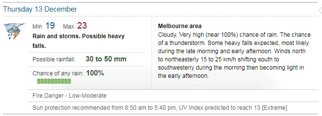
BOM just updated.
other places you will find me...
My blog...http://www.wolfcat.com.au/randomrants/
Flickr .. http://www.flickr.com/photos/wolfcat_aus/
Twitter... http://twitter.com/wolfcat
Redbubble... http://www.redbubble.com/people/wolfcat
My blog...http://www.wolfcat.com.au/randomrants/
Flickr .. http://www.flickr.com/photos/wolfcat_aus/
Twitter... http://twitter.com/wolfcat
Redbubble... http://www.redbubble.com/people/wolfcat