Yes heavy rain and one clap of thunder too here in the last hour.
Just over 10mm's so far takes me above the monthly average.

Welcome New Members! We want to hear from you. Register, stop lurking and start posting!
VIC - Front with gales and showers: July 23-26 2018
-
occluded

- Cumulonumbus Calvas
- Reactions:
- Posts: 611
- Joined: Tue May 04, 2010 3:26 pm
- Location: Mooroolbark 130m asl
Re: VIC - Front with gales and showers: July 23-26 2018
Feral disgusting wind yesterday - wind chill was quite something.
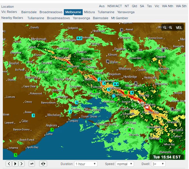
Ramping up nicely now with sheets of rain
Ramping up nicely now with sheets of rain
-
hillybilly

- Site Admin/Moderator
- Reactions:
- Posts: 4978
- Joined: Thu Nov 26, 2009 7:26 am
- Location: Howden Tasmania, 25m above sea level
- Contact:
Re: VIC - Front with gales and showers: July 23-26 2018
Like a summer deluge here. Insane rainfall rate - peaked at 160mm/hr  Gutters all overflowing in sheets. Not seen anything like this in winter before.
Winds are feral and now getting small hail.
Couple of photos. 14mm and counting. May it keep coming


Winds are feral and now getting small hail.
Couple of photos. 14mm and counting. May it keep coming
- wolfcat
- Cumulonumbus Calvas
- Reactions:
- Posts: 562
- Joined: Sun Mar 07, 2010 12:14 pm
- Location: Bentleigh East
- Contact:
Re: VIC - Front with gales and showers: July 23-26 2018
And boom, suddenly a thunderstorm pops up in that band.
other places you will find me...
My blog...http://www.wolfcat.com.au/randomrants/
Flickr .. http://www.flickr.com/photos/wolfcat_aus/
Twitter... http://twitter.com/wolfcat
Redbubble... http://www.redbubble.com/people/wolfcat
My blog...http://www.wolfcat.com.au/randomrants/
Flickr .. http://www.flickr.com/photos/wolfcat_aus/
Twitter... http://twitter.com/wolfcat
Redbubble... http://www.redbubble.com/people/wolfcat
- tonycynic
- Cumulonimbus
- Reactions:
- Posts: 494
- Joined: Tue Feb 15, 2011 5:57 pm
- Location: Mount Evelyn (h),Donvale (w)
Re: VIC - Front with gales and showers: July 23-26 2018
Well that was fun, drove under the downpour from Dandenong to Lilydale. Carnage out there, somany people without lights on. Lots of driveways are now on the road.
- JasmineStorm
- Supercell
- Reactions:
- Posts: 1870
- Joined: Thu Sep 22, 2016 9:40 pm
- Location: Kyneton 527 ASL
Re: VIC - Front with gales and showers: July 23-26 2018
9mm so far for part 2. 19mm for the thread so far. Light rain now.
Looks like you were in the sweet spot HB.
Looks like you were in the sweet spot HB.
-
hillybilly
- Site Admin/Moderator
- Reactions:
- Posts: 4978
- Joined: Thu Nov 26, 2009 7:26 am
- Location: Howden Tasmania, 25m above sea level
- Contact:
Re: VIC - Front with gales and showers: July 23-26 2018
16.6mm at home and 16.2mm at the local AWS so a good match. Much cooler now and foggy.
One more front of types to come tomorrow, before the next bubble high (and then a return of westerly gales). Be good to crack 20mm for this mini event, which has to be a chance.
One more front of types to come tomorrow, before the next bubble high (and then a return of westerly gales). Be good to crack 20mm for this mini event, which has to be a chance.
- Tassiedave
- Supercell
- Reactions:
- Posts: 1098
- Joined: Thu Nov 11, 2010 11:09 am
- Location: Grindelwald Tasmania
Re: VIC - Front with gales and showers: July 23-26 2018
Rainfall in Tas since 9 am: Mt Victoria 29mm, Sheffield 25mm, Mt Barrow 25mm, Nunamara 22mm, Scottsdale 13mm, Wynyard 11mm, Launceston 9.2mm
- StratoBendigo
- Supercell
- Reactions:
- Posts: 2809
- Joined: Fri Jan 02, 2015 2:18 pm
- Location: Kangaroo Flat
Re: VIC - Front with gales and showers: July 23-26 2018
Another 5mm this evening. That's 17mm this week 
-
Onetahuti

- Supercell
- Reactions:
- Posts: 2790
- Joined: Thu Mar 25, 2010 9:37 pm
- Location: Dandenong Nth.
Re: VIC - Front with gales and showers: July 23-26 2018
Finished up with 12.0mm, on the topside of the Melbourne Water Rowville site but have no reason to suspect the total, just a minute or two in rainfall intensity would do it.
- Macedonian
- Supercell
- Reactions:
- Posts: 2330
- Joined: Mon Dec 21, 2009 10:44 pm
- Location: Mount Macedon Vic at 870m above sea level
Re: VIC - Front with gales and showers: July 23-26 2018
24mm here since 5pm yesterday.
Few snowflakes and sleet last night and splattery icy rain on the way home this afternoon.
I drove out to Maldon this afternoon, fairly green but low dams and tiny creek flows.
We need so much more rain before summer hits. Hope it happens.
Few snowflakes and sleet last night and splattery icy rain on the way home this afternoon.
I drove out to Maldon this afternoon, fairly green but low dams and tiny creek flows.
We need so much more rain before summer hits. Hope it happens.
Home- "Shepherd's Bush" at Mt Macedon. 870m
Work- "Bolobek" at Macedon. 430m
Work- "Bolobek" at Macedon. 430m
- StratoBendigo
- Supercell
- Reactions:
- Posts: 2809
- Joined: Fri Jan 02, 2015 2:18 pm
- Location: Kangaroo Flat
Re: VIC - Front with gales and showers: July 23-26 2018
Our dry start to the year hasn't helped. We're in catch-up mode at present, but the next 2 weeks look quite good IMO.Macedonian wrote: ↑Tue Jul 24, 2018 6:50 pm 24mm here since 5pm yesterday.
Few snowflakes and sleet last night and splattery icy rain on the way home this afternoon.
I drove out to Maldon this afternoon, fairly green but low dams and tiny creek flows.
We need so much more rain before summer hits. Hope it happens.
- snowfall
- Supercell
- Reactions:
- Posts: 1283
- Joined: Mon Mar 20, 2017 7:39 pm
- Location: Gisborne South (349m asl)
Re: VIC - Front with gales and showers: July 23-26 2018
8mm here today and 12mm for the past 24 hours. We were just outside the heaviest rain last night by only a few kms, so missed out a bit, but it’s a good top up nonetheless. Wind has calmed right down thankfully.
- Gordon
- Supercell
- Reactions:
- Posts: 2887
- Joined: Thu Jun 17, 2010 10:01 am
- Location: Near Gordon, Vic. 620 m asl
Re: VIC - Front with gales and showers: July 23-26 2018
12mm from that lot, brings us to 64mm mtd vs our longterm average for July of 81mm. Looks like we'll be a chance to make it.
-
hillybilly
- Site Admin/Moderator
- Reactions:
- Posts: 4978
- Joined: Thu Nov 26, 2009 7:26 am
- Location: Howden Tasmania, 25m above sea level
- Contact:
Re: VIC - Front with gales and showers: July 23-26 2018
It’s been really noticeable here. We had about average when you combine May and June, but things are really dry. Creek flows are low, and the forests have almost no standing water. It needs to keep rain, otherwise summer could get nasty fast.Our dry start to the year hasn't helped. We're in catch-up mode at present, but the next 2 weeks look quite good IMO.
The further north you go the worse, with NSW parched. There are a lot of bushfires already up there.
Btw strangely mild post this front. Nearly 11C in the city and been raining across the alps this arvo. Slowly cooling off, but odd gettting such mild air following such a cracker of a frontal passage.
- StratoBendigo
- Supercell
- Reactions:
- Posts: 2809
- Joined: Fri Jan 02, 2015 2:18 pm
- Location: Kangaroo Flat
Re: VIC - Front with gales and showers: July 23-26 2018
A pea-souper fog this morning.
It'll be interesting to see the wind anomalies for July. Anecdotally lots of wild westerlies.
It'll be interesting to see the wind anomalies for July. Anecdotally lots of wild westerlies.
- JasmineStorm
- Supercell
- Reactions:
- Posts: 1870
- Joined: Thu Sep 22, 2016 9:40 pm
- Location: Kyneton 527 ASL
Re: VIC - Front with gales and showers: July 23-26 2018
Atmospheric Indicators are going rogue on todays latest projections and observations ..... http://www.theaustralianweatherforum.co ... 04#p105904
- StratoBendigo
- Supercell
- Reactions:
- Posts: 2809
- Joined: Fri Jan 02, 2015 2:18 pm
- Location: Kangaroo Flat
Re: VIC - Front with gales and showers: July 23-26 2018
Fun times ahead next week. GFS seems to responding to it and this could mean 1m+ of snow dumped on the Alps...JasmineStorm wrote: ↑Wed Jul 25, 2018 11:12 am Atmospheric Indicators are going rogue on todays latest projections and observations ..... http://www.theaustralianweatherforum.co ... 04#p105904
- Dane
- Supercell
- Reactions:
- Posts: 1661
- Joined: Thu Nov 26, 2009 9:51 am
- Location: Sebastopol 420m ASL
- Contact:
Re: VIC - Front with gales and showers: July 23-26 2018
11.2mm's in the 24 hours to 9am taking the MTD to 80.6mm's (Ave 72mm's).
YTD is 350mm's yearly average is 772mm's.
YTD is 350mm's yearly average is 772mm's.
- flyfisher
- Cumulonimbus
- Reactions:
- Posts: 250
- Joined: Wed Jul 18, 2012 1:39 pm
- Location: Belgrave
- Contact:
Re: VIC - Front with gales and showers: July 23-26 2018
Looks amazing on GFS run. It still won't connect to the tropics so it's moisture starved, particularly NSW and Qld. I can see some of the biggest dust storms in history if those predicted charts become reality. The westerly belt high over NSW. Could also cause bushfires.
Looking at the Indian ocean, it's warmed a little but generally cool overall. Looking at the currents, the developing El Nino in the Pacific is assisting the current to deflect around the Philippines and head back east into the Pacific. It's stopping any warm water coming through Indonesia. So we are relying on local solar heating in that important area and reduced trades. Low-level air flow which is Nino influenced is dry and so that has been undercutting the little mid-level moisture we are getting.
Except for last night which was a beauty. First time in a long while I watched a squall line actually strengthen as it headed east to give 10mm of welcome rain.