
Yeah, there is some mighty impressive numbers right through southern NSW and east SA. Severe storms look a certainty over that area. Why oh why can't it be further south though? Couple of 100k's further south and I would be chasing without a doubt. What direction do you think these storms will move in John? Think some intercepts are the best I can hope for based on the current outlook, tho very tempted to just say screw it and drive up in to NSW to get a fix, hehe.
Edit: Interesting to note and I think you already made mention of it already...if you go back a few runs, there is basically no storm potential in NSW, so a lot to change in terms of location over the next few days...

Welcome New Members! We want to hear from you. Register, stop lurking and start posting!
Storms SA, NSW, VIC 3-5 Sept. Inc Broadford Tornado
Re: Convective Forecast: 3-5 September 2010
Last edited by Meso on Tue Aug 31, 2010 5:09 pm, edited 1 time in total.
-
Karl Lijnders

- Tornadic Supercell
- Reactions:
- Posts: 5771
- Joined: Sun Nov 22, 2009 11:17 pm
- Location: Knoxfield, Victoria
Re: Convective Forecast: 3-5 September 2010
This area of thunderstorms will flatten out to thundery rain and affect VIC Saturday and Saturday night. Could be a noisy and sparky rainband but mainly embedded stuff in the south and more singular cell likelyhood in the north.
Good times and good forecast John!!
Good times and good forecast John!!
Former Owner - The Australian Weather Forum. Email me anytime - weatherman1000@hotmail.com
-
Anthony Violi

- Supercell
- Reactions:
- Posts: 2652
- Joined: Mon Nov 23, 2009 9:03 pm
- Location: Lilydale
- Contact:
Re: Convective Forecast: 3-5 September 2010
Very good forecast, will literally be one that needs to be watched as development position is still just hinting at being pushed East with every run fractionally.
Griffith is usually a hot spot too so with EC tonight could see a very large band of thunderstorms move in from the N or NW Fri/Sat. The potential is there for some huge storms, another 5 degrees at the surface would have been nice!
BTW John, flash flooding the main concern for severe criteria?
Griffith is usually a hot spot too so with EC tonight could see a very large band of thunderstorms move in from the N or NW Fri/Sat. The potential is there for some huge storms, another 5 degrees at the surface would have been nice!
BTW John, flash flooding the main concern for severe criteria?
http://www.therealworldweatherforum.com" onclick="window.open(this.href);return false;
avweatherforecasts.com
avweatherforecasts.com
- Jake Smethurst
- Supercell
- Reactions:
- Posts: 3583
- Joined: Mon Nov 23, 2009 8:49 pm
- Location: Cheltenham
Re: Convective Forecast: 3-5 September 2010
Beautiful forecast John. Hopeing to contribute later Friday after school/milking and on the weekend. My storm charts are getting a revamp at the moment.
Some very healthy numbers being popped out by GFS at the moment (cannot wait till ACCESS get's CAPE and LI values) and some very big thunderstorms are on the way. Will check models out more closely closer to the event, I don't have time now (have two exams in the next 2-days!).
Keep the great forecasts up John.
Jake - Senior AWF Forecaster
Feel free to send me a private message if you have any questions.
Feel free to send me a private message if you have any questions.
Re: Convective Forecast: 3-5 September 2010
This is a very interesting system indeed. I'm keeping an open mind about any tornadic potential for SE Oz in general until about a day or two out and models firm up, given the belt of strong low-level shear progged around the low (e.g. 20kt NNE'lies at the surface backing around to 60kt by 900hpa/1km in some places ahead of the low), vertical stretching and vorticity from the tight cyclonic curvature near the low, etc. But from the quick glance I had today, it looked like most areas of sufficient CAPE weren't co-inciding too well with the strongest low level shear/helicity. In any case, will have a closer look at all this as well as the hail-CAPE amounts in a day or two.
- Twister
- Cumulonumbus Calvas
- Reactions:
- Posts: 914
- Joined: Sun Nov 29, 2009 10:47 pm
- Location: Brisbane Qld
Re: Convective Forecast: 3-5 September 2010
Yes i can see what you mean TU about NSW looking quite interesting Thursday and Friday looks very interesting and with the QLD and NT moisture moving S SW quite quickly things look like picking up a bit for NSW on Thursday now interesting times, but will have to have another 24 hours to have a better idea
Great looking system Storms in SA and NSW should be quite impressive Saturday looking quite good Saturday to
Like the steepish lapse rates to quite nice not huge but nice
Great looking system Storms in SA and NSW should be quite impressive Saturday looking quite good Saturday to
Like the steepish lapse rates to quite nice not huge but nice
Now Living in Wet QLD
Re: Convective Forecast: 3-5 September 2010
Latest run is inching further south. Few more runs and the greatest area of instability may well be in northen Vic. Lets just hope it doesn't push too far east.
Re: Convective Forecast: 3-5 September 2010
Somewhat of a downgrade in the 00z run. Pretty similar to last run with CAPE peaking in SA early in the afternoon, but the area I see a downgrade now is S NSW with CAPE only hitting 800 back up around Griffith again (there was values up to 1400 near Hay in the last run) and a similar downgrade of the Lifted Index with only a small area around Griffith getting to down to -4.
NE/E SA still looks to be very unstable though so I'm not entirely sure what these minor downgrades in NSW mean. Shorter life-cycle maybe? With the environment the storms will be moving in to being a little more stable then was previously predicted? Or am I way off?
NE/E SA still looks to be very unstable though so I'm not entirely sure what these minor downgrades in NSW mean. Shorter life-cycle maybe? With the environment the storms will be moving in to being a little more stable then was previously predicted? Or am I way off?
Re: Convective Forecast: 3-5 September 2010
What do you mean? All of it's probably worth taking with a grain of salt until tomorrow night really.
-
Blackee

- Site Admin/Moderator
- Reactions:
- Posts: 3857
- Joined: Tue Nov 24, 2009 8:57 pm
- Location: Elwood and Mansfield 370m
Re: Convective Forecast: 3-5 September 2010
Good luck with the chase John (and I presume Brad as well!)
Latest stormcast makes interesting reading for Saturday in VIC.
Below is link to 1400hr chart on Saturday.
http://forecasts.bsch.au.com/stormcast. ... #stormcast
Latest stormcast makes interesting reading for Saturday in VIC.
Below is link to 1400hr chart on Saturday.
http://forecasts.bsch.au.com/stormcast. ... #stormcast
Mansfield 370m and Elwood
Re: Convective Forecast: 3-5 September 2010
Yeah, count me out for tomorrow. Shame, it was looking really good for a while there with stormcast spitting out some impressive numbers, but it's simply too far for me to go, especially when the days still aren't very long.
Saturday on the other hand is looking very interesting now, hopefully the forecast can hold or even improve a little and a trip up to the north east will definitely be on the cards!
Questions for those with more understanding of the models then me...are those numbers it's giving for 2 and 5pm across NE Vic good enough for supercells (they seem roughly the same as the storms a couple of weeks ago)? Or are we just looking at run of the mill storms? And does the smaller area of instability (when compared with Friday) mean we are more likely to see isolated cells?
Re: Convective Forecast: 3-5 September 2010
One other question...with all this rain forecast for Friday/Saturday is it gonna clear behind the main rain areas before storms kick off or are we talking embedded storms, which obviously wouldn't be ideal for chasing?
Re: Convective Forecast: 3-5 September 2010
Latest run not looking quite as good for southern areas, but pretty much the same for the N/NE. Keen to hear your take on it John.
-
brayden

- Cumulonimbus
- Reactions:
- Posts: 225
- Joined: Thu Dec 31, 2009 9:54 am
- Location: Perth. Originally Wodonga, Vic
Re: Convective Forecast: 3-5 September 2010
Good to see some proper cells firing around central Aus atm. Hopefully some of you SA people go for a chase tommorow 
"I'm in with the sane, does that make me Insane?"
"I lycra like that"
"I lycra like that"
- Twister
- Cumulonumbus Calvas
- Reactions:
- Posts: 914
- Joined: Sun Nov 29, 2009 10:47 pm
- Location: Brisbane Qld
Re: Convective Forecast: 3-5 September 2010
HUGE Storms N NW of Adel and continuing to build, should see an even bigger explosion in N NE SA later today looking unreal what a system looking to be a huge day of storms in SA lucky buggers.
Very lightening active, very wet, and the northern cell near Woomera is looking quite severe
Very lightening active, very wet, and the northern cell near Woomera is looking quite severe
Now Living in Wet QLD
- Hamlan
- Storm Chaser
- Reactions:
- Posts: 449
- Joined: Tue Dec 22, 2009 11:05 pm
- Location: Northern suburbs
Re: Convective Forecast: 3-5 September 2010
Awesome radar and lightning returns already! that is a barrage of sparkies. Squall line moving SE from east of Woomera with a very intense cell attached to its southern end although it looks to me that there will be further development to the south of this intense cell and the squall will grow in length with Port Augusta in its sights.
-
Blackee
- Site Admin/Moderator
- Reactions:
- Posts: 3857
- Joined: Tue Nov 24, 2009 8:57 pm
- Location: Elwood and Mansfield 370m
Re: Convective Forecast: 3-5 September 2010
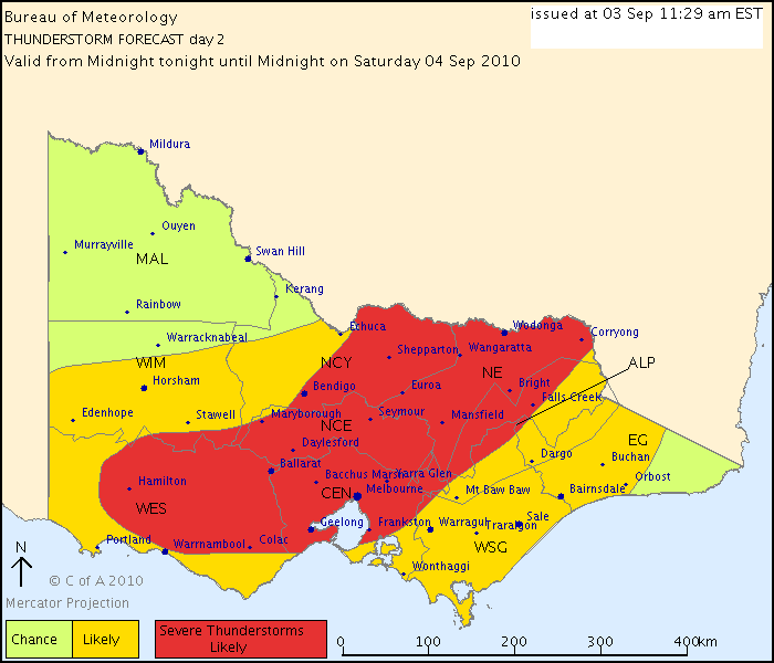
THUNDERSTORM FORECAST
Issued at 11:13 am Friday, 3 September 2010,
Valid until midnight on Friday, 3 September 2010.
A low pressure system continues to develop over South Australia and is expected
to be centred near Adelaide by this evening. As the low develops, warm and moist
air will advecting southwards over northern Victoria. Isolated thunderstorms are
a slight risk in the northwest this evening.
DAY 2 THUNDERSTORM FORECAST
Issued at 11:29 am Friday, 3 September 2010,
Valid from midnight tonight until midnight on Saturday, 4 September 2010.
On Saturday the low near Adelaide will intensify as it moves southeastwards
across southwestern Victoria to be near Tasmania Saturday night. Heavy rain,
thunderstorms and gale force winds are likely over much of the State with the
area of the most intense thunderstorm activity expected to extend from the
northeast towards the Western district.
Mansfield 370m and Elwood
- Harley34
- Cumulonumbus Calvas
- Reactions:
- Posts: 580
- Joined: Sat Mar 06, 2010 1:08 pm
- Location: Ringwood East, Melbourne
Re: Convective Forecast: 3-5 September 2010
So Melbourne is on the firing line for severe thunderstorms tomorrow afternoon? What sort of thunderstorms (Supercells, mulitcells, squall lines, etc)?
That thunderstorm chart has definately lifted my optimism for tomorrow. Cheers Snipes.
That thunderstorm chart has definately lifted my optimism for tomorrow. Cheers Snipes.
- Petethemoskeet
- Cumulonimbus
- Reactions:
- Posts: 272
- Joined: Mon Mar 08, 2010 1:06 pm
- Location: Toowoomba
Re: Convective Forecast: 3-5 September 2010
Camera is at the ready for the weekend so lets hope it pans out as forecast.
- Harley34
- Cumulonumbus Calvas
- Reactions:
- Posts: 580
- Joined: Sat Mar 06, 2010 1:08 pm
- Location: Ringwood East, Melbourne
Re: Convective Forecast: 3-5 September 2010
Updraft, how are diagnostics for Melbourne in terms of tstorms?