http://baliset.blogspot.com.au/2011/01/ ... od-in.html" onclick="window.open(this.href);return false;
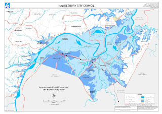
The map below shows the extent of the largest historical flood experienced in the Hawkesbury, in 1867. If you live around the Hawkesbury, there are two markers you need to visit. One is a nail in the outside wall of the Macquarie Arms pub at Windsor. A second is in the grounds of Windsor Public School. If you cast your eyes across from either of those points and use your imagination, you may get a sense of the scale of a major flood. The water reached that level in 1867. Now look at that map again. If you live in the Hawkesbury, there's a better than even chance that your home lays in that blue area, since our population is densest around Windsor, South Windsor, Bligh Park, Richmond and so on. And any flood will not have to be of the scale of the 1867 event to be catastrophic.
He provides a map showing the area that was impacted by the 1867 floods and discussion on a future scenario