That's right Andrew...the heavy falls happened but further East from here...same deal this time, they will occur just a matter of where.
12z GFS has bought the rain back, with interest. I still feel the band will tilt and begin to wrap in response to the upper low, hence EC should come back on either this morning or tonight for the double dip scenario.

Welcome New Members! We want to hear from you. Register, stop lurking and start posting!
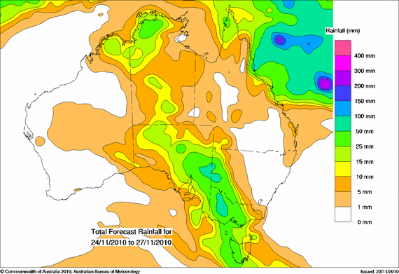
Victoria: Rain/Storm Event (Analysis) November 22-28 2010
-
Anthony Violi

- Supercell
- Reactions:
- Posts: 2652
- Joined: Mon Nov 23, 2009 9:03 pm
- Location: Lilydale
- Contact:
Re: Victoria: Rain/Storm Event (Analysis) November 22-28 20
http://www.therealworldweatherforum.com" onclick="window.open(this.href);return false;
avweatherforecasts.com
avweatherforecasts.com
-
Blackee

- Site Admin/Moderator
- Reactions:
- Posts: 3857
- Joined: Tue Nov 24, 2009 8:57 pm
- Location: Elwood and Mansfield 370m
Re: Victoria: Rain/Storm Event (Analysis) November 22-28 20
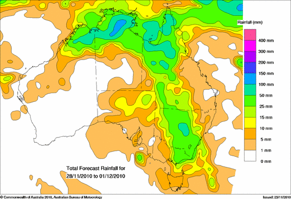
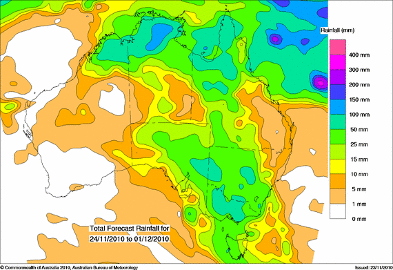
Access has good falls developing in Western districts early this afternoon before extending east by 1800rs.
At this stage, it appears that the key part of this system in terms of rainfall is late Saturday & Sunday
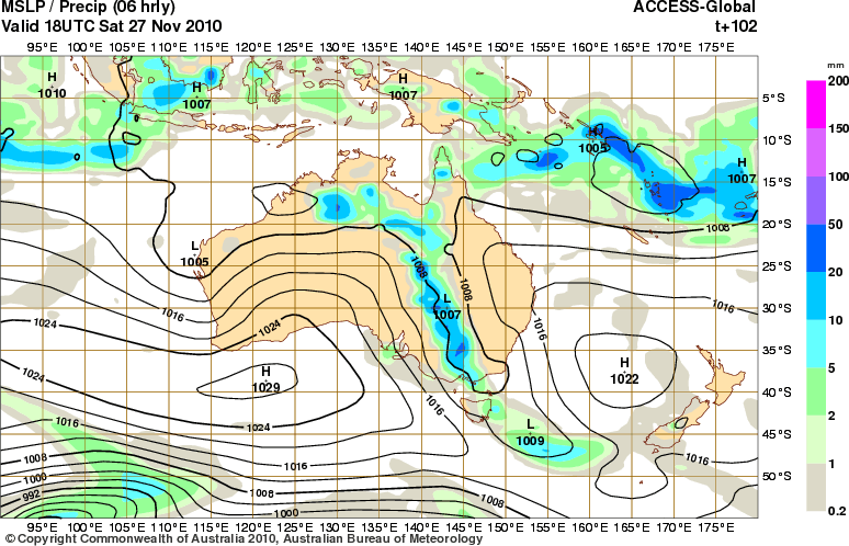
EC yet to get completely onboard with the high totals.
At this stage, it appears that the key part of this system in terms of rainfall is late Saturday & Sunday
EC yet to get completely onboard with the high totals.
Mansfield 370m and Elwood
-
Blackee
- Site Admin/Moderator
- Reactions:
- Posts: 3857
- Joined: Tue Nov 24, 2009 8:57 pm
- Location: Elwood and Mansfield 370m
Re: Victoria: Rain/Storm Event (Analysis) November 22-28 20
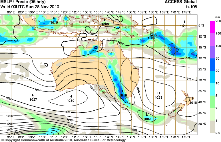
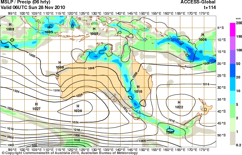
This mornings WATL charts.
Mansfield 370m and Elwood
-
Karl Lijnders

- Tornadic Supercell
- Reactions:
- Posts: 5771
- Joined: Sun Nov 22, 2009 11:17 pm
- Location: Knoxfield, Victoria
Re: Victoria: Rain/Storm Event (Analysis) November 22-28 20
Yeah I think 20-50mm is a good bet for Melbourne at this time. Cannot see much more than that. Mainly dry next week IMO, humid, but isolated showers and storms likely from Wednesday again.
Former Owner - The Australian Weather Forum. Email me anytime - weatherman1000@hotmail.com
- HarleyB
- Cumulonumbus Calvas
- Reactions:
- Posts: 839
- Joined: Sun Oct 10, 2010 9:39 pm
- Location: Wangaratta
Re: Victoria: Rain/Storm Event (Analysis) November 22-28 20
Gee wizz, the models came back this morning, big time. Will say 25mm for here still at this stage, erring on the side of caution, and wishful thinking because we have only played 2 games out of 6 in cricket this season so far. Some places will get upwards of 100mm though outside of the usual north east.
-
Karl Lijnders
- Tornadic Supercell
- Reactions:
- Posts: 5771
- Joined: Sun Nov 22, 2009 11:17 pm
- Location: Knoxfield, Victoria
Re: Victoria: Rain/Storm Event (Analysis) November 22-28 20
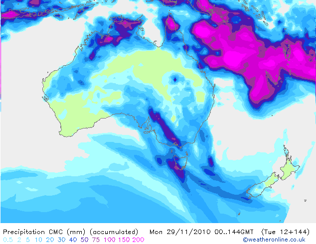
Latest CMC (Canadian Weather Model) Rainfall the next week.
Former Owner - The Australian Weather Forum. Email me anytime - weatherman1000@hotmail.com
Re: Victoria: Rain/Storm Event (Analysis) November 22-28 20
I am unsure how long this event will play out i think the blocking high will move in pretty fast and clear it out, I think its safe to say that there will be good rain untill Sat but after that i think it will dry up with the Big H's.
I could be wrong.
I could be wrong.
- I_Love_Storms
- Supercell
- Reactions:
- Posts: 2812
- Joined: Wed Dec 02, 2009 2:01 pm
- Location: Hawthorn
Re: Victoria: Rain/Storm Event (Analysis) November 22-28 20
Sounds like a pretty big downgrade from the majority is this right? GFS still holding for a BIG scenario.
-
Blackee
- Site Admin/Moderator
- Reactions:
- Posts: 3857
- Joined: Tue Nov 24, 2009 8:57 pm
- Location: Elwood and Mansfield 370m
Re: Victoria: Rain/Storm Event (Analysis) November 22-28 20
I expect the main area of instability (and storm activity) around Ballarat/ Beaufort/Mortlake/Colac and sliding SE thru the Bellarine Peninsula.
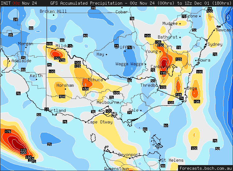
GFS 18z maintains good falls over the next 96hrs.
EDIT: 180hr chart attached.
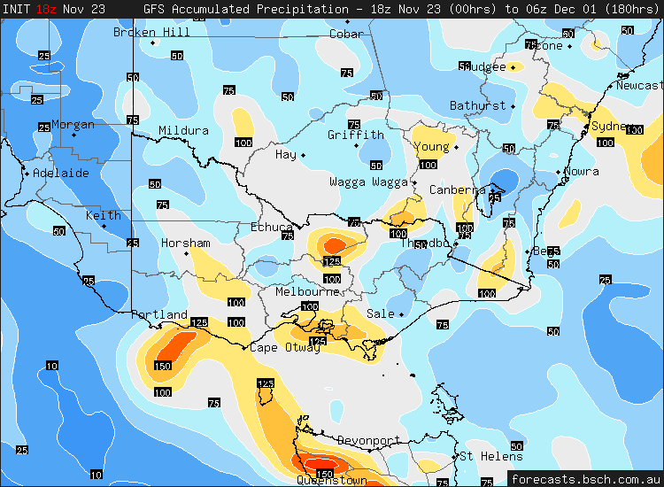
GFS 18z maintains good falls over the next 96hrs.
EDIT: 180hr chart attached.
Mansfield 370m and Elwood
-
Blackee
- Site Admin/Moderator
- Reactions:
- Posts: 3857
- Joined: Tue Nov 24, 2009 8:57 pm
- Location: Elwood and Mansfield 370m
Re: Victoria: Rain/Storm Event (Analysis) November 22-28 20
Herald Sun has latched onto the upcoming event!
VICTORIA'S warm spell will end tonight as thunderstorms sweep through the state, bringing rain that is expected to last for several days.
Melbourne is forecast to reach 31 degrees today before heavy rain dumps on peak-hour commuters, along with possible thunder and lightning, anytime after 5pm, the Bureau of Meteorology's Rod Dickson said.
Regular rainfall will continue throughout the week, with the wettest weather likely to come on Saturday.
"This trough that's around is going to linger over the state well into the weekend," Mr Dickson said.
"Cumulatively, we could see 30-50mm of rain in Melbourne to this time next week."
The change will also deliver cooler temperatures after two successive days over 32 degrees.
However, despite another drenching on the way, Victoria is still at least three years away from recovering from drought.
Climate meteorologist Dr Harvey Stern said recent wet weather had done little to repair damage from more than 14 years of dry conditions.
"There's a pretty large area of central Victoria that has had the driest period on record over the last 14 years," Dr Stern said.
"One wet year won't eliminate all the deficiencies."
Most of Victoria is classed as being under exceptional drought circumstances by the federal Department of Agriculture, Fisheries and Forestry.
Dr Stern said while this year's above-average rainfall was a bonus, another three years or more of similar conditions was needed before the state would fully recover.
"Over the last 14-15 years we've missed out on the equivalent of two years' rainfall over much of Victoria so it will take a while to make up for that," he said.
Weather bureau duty forecaster Stuart Coombs said the drought had caused so much damage, it was difficult to predict how quickly Victoria could recover.
"We'd need several years like this one to recharge ground moisture for a start," Mr Coombs said.
"You'd need significant rainfall over a period of time to repair the damage."
Mansfield 370m and Elwood
-
Blackee
- Site Admin/Moderator
- Reactions:
- Posts: 3857
- Joined: Tue Nov 24, 2009 8:57 pm
- Location: Elwood and Mansfield 370m
Re: Victoria: Rain/Storm Event (Analysis) November 22-28 20
Fire Weather Briefing for Victoria
Issued at 10:41 am EDT on Wednesday 24 November 2010.
Weather Situation:
An near stationary high pressure system is over the Tasman Sea. A trough of low
pressure over the Bight will reach western Victoria late Wednesday then will
slow to remain over western and central Victoria from Thursday right through
until Saturday.
24 Hour Rainfall to 9am:
Isolated convective showers across elevated areas producing less then 2mm.
Weather Today:
Scattered showers and isolated thunderstorms developing over the western areas
of the State in the afternoon to reach central parts in the evening. Remaining
dry over eastern districts. A warm to hot, humid day with cloud increasing from
the west. Generally moderate to fresh northerly winds, although a cooler west
to southwest change developing over the southwest in the afternoon.
Mansfield 370m and Elwood
-
Blackee
- Site Admin/Moderator
- Reactions:
- Posts: 3857
- Joined: Tue Nov 24, 2009 8:57 pm
- Location: Elwood and Mansfield 370m
Re: Victoria: Rain/Storm Event (Analysis) November 22-28 20
Soundings are out, and Central areas need to reach a minimum 31/14 (perhaps even 32/14) to get things going. Cloud cover may inhibit temps, but an increase in DP's may provide a strong enough trigger.
Now we await the BOM TS chart.
Now we await the BOM TS chart.
Mansfield 370m and Elwood
-
Blackee
- Site Admin/Moderator
- Reactions:
- Posts: 3857
- Joined: Tue Nov 24, 2009 8:57 pm
- Location: Elwood and Mansfield 370m
Re: Victoria: Rain/Storm Event (Analysis) November 22-28 20
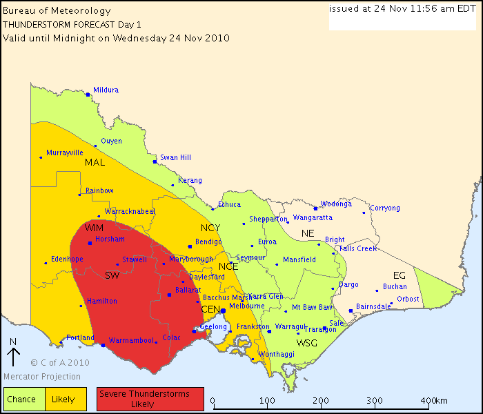
THUNDERSTORM FORECAST
Issued at 11:56 am Wednesday, 24 November 2010,
Valid until midnight on Wednesday, 24 November 2010.
There is a significant risk of thunderstorms over central and western Victoria this afternoon and evening with high moisture levels and the passage of a low pressure trough. There is the low risk of afternoon thunderstorms about the eastern ranges and far east Gippsland. Due to moisture levels increasing from the west, there is quite a high chance of severe thunderstorms developing over central or western parts, most likely in the area indicated. Bursts of heavy rainfall leading to flash flooding or large hail are the most likely severe phenomena, but damaging wind gusts are also a risk.
Mansfield 370m and Elwood
Re: Victoria: Rain/Storm Event (Analysis) November 22-28 20
BOM's forecast  seriously have not seen them forecast nearly a week of weather like this!
Forecast for Thursday
Cloudy. Areas of rain. Isolated thunderstorms from the late morning. Winds mainly northwesterly averaging up to 20 km/h tending southwesterly and light by early evening.
Forecast for Friday
Cloudy. Areas of rain. Isolated thunderstorms possible from midday. Light winds.
Forecast for Saturday
Cloudy. Patchy rain, increasing around midday. Isolated thunderstorms possible. Winds northeasterly averaging up to 20 km/h tending north to northeasterly up to 30 km/h during the afternoon.
Forecast for Sunday
Cloudy. Areas of rain and the chance of isolated thunderstorms. Winds north to northeasterly averaging up to 20 km/h.
Forecast for Monday
Cloudy. Areas of rain and the chance of isolated thunderstorms. Winds east to southeasterly averaging up to 20 km/h.
Forecast for Tuesday
Cloudy. Areas of rain. Isolated thunderstorms possible later in the day. Winds northeasterly and light tending north to northeasterly up to 30 km/h during the morning.
- Lily
- Supercell
- Reactions:
- Posts: 4014
- Joined: Wed Nov 25, 2009 10:29 pm
- Location: Rowville/Lysterfield
Re: Victoria: Rain/Storm Event (Analysis) November 22-28 20
And yet the BOM were on 3AW this morning (I think it was Dean at around 11am?) stating that beyond the weekend, they were unsure of what the conditions would be as the models were confusing them too!
- Jake Smethurst
- Supercell
- Reactions:
- Posts: 3583
- Joined: Mon Nov 23, 2009 8:49 pm
- Location: Cheltenham
Re: Victoria: Rain/Storm Event (Analysis) November 22-28 20
Good to see the pro's confused by the models. The BoM mentioned this on our local radio this morning too.
Otherwise, conditons generally playing out as expected. Here is my latest thunderstorm details, unfortunatley, due to being at school, I cannot update the map that goes with it.
Thunderstorm Forecast - Day 1 (Wednesday) Issued 2:03 PM EDT 24/11/2010
Isolated thunderstorm activity is possible over the western districts during Wednesday as a trough of low pressure approaches this region. The 'chance' area will extend into parts of the Central districts including Melbourne late on Wednesday. Thunderstorm activity is more likely over the Southwest and Wimmera districts where instability is stronger and 0-6 KM shear is better; 0-1 KM shear remains marginal. Moisture levels across the state are expected to be prime for development, with DP's in the teens across all of the state. Another area to watch is the far northeast where there is a slim chance that lift from the ranges may cause deep enough convection to cause an isolated thunderstorm. Severe activity is possible on Wednesday afternoon and is more likely over the Southwest district, particularly east of Portland. Flash flooding and large hail is the biggest concern, however damaging winds also are a risk. It should be mentioned that there is a small chance for a supercell over the southwest in the shear environment in that area.
Jake - Senior AWF Forecaster
Feel free to send me a private message if you have any questions.
Feel free to send me a private message if you have any questions.
-
Blackee
- Site Admin/Moderator
- Reactions:
- Posts: 3857
- Joined: Tue Nov 24, 2009 8:57 pm
- Location: Elwood and Mansfield 370m
Re: Victoria: Rain/Storm Event (Analysis) November 22-28 20
I can't really add too much more to this image!
Mansfield 370m and Elwood
-
Blackee
- Site Admin/Moderator
- Reactions:
- Posts: 3857
- Joined: Tue Nov 24, 2009 8:57 pm
- Location: Elwood and Mansfield 370m
Re: Victoria: Rain/Storm Event (Analysis) November 22-28 20
Looking at the 1615 forecasts, BOM going much more conservative.
Few showers forecast for Fri/Mon/Tues. Rain on Saturday, Shower or two on Sunday.
Obviously taking GFS run with a grain of salt!
Few showers forecast for Fri/Mon/Tues. Rain on Saturday, Shower or two on Sunday.
Obviously taking GFS run with a grain of salt!
Mansfield 370m and Elwood
Re: Victoria: Rain/Storm Event (Analysis) November 22-28 20
And rain Tomorrow, storms still a chance Tomorrow, Friday, Saturday, heavy falls have been added in Tonights forecast and Saturdays forecast, rain still Sunday morning so not much of a downgrade really but more a realistic forecast as far as I'm concerned Wes.
Actually just seen GFS and falls more into line with EC with a deepening low SW of Vic later Saturday moveing SE Sunday then clearing before slowly becoming unstable again next week but mostly NE/E of the state so the BOM forecast is good at this stage.
The bulk of that rain is now Tonight/Tomorrow and Saturday/Early Sunday. Was/is never going to happen were going to get 6 days of rain periods in a row.
Interesting though Latest UKMET still doesn't have a low in the trough Saturday just more a deep broad trough but its an outliner at this stage
- Jake Smethurst
- Supercell
- Reactions:
- Posts: 3583
- Joined: Mon Nov 23, 2009 8:49 pm
- Location: Cheltenham
Re: Victoria: Rain/Storm Event (Analysis) November 22-28 20
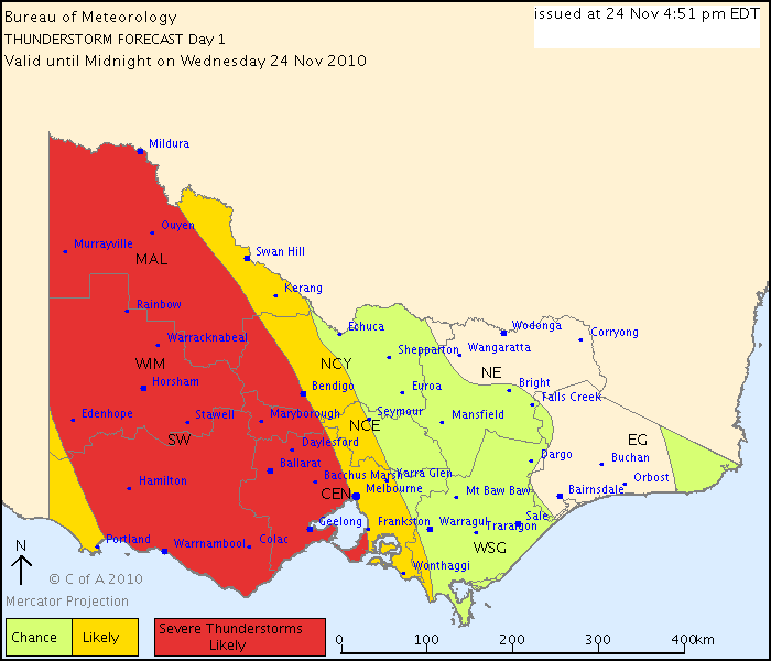
Updated Official Storm Chart from the BoM:
Australian Government Bureau of Meteorology
Victoria Regional Office
THUNDERSTORM FORECAST
Issued at 4:51 pm Wednesday, 24 November 2010,
Valid until midnight on Wednesday, 24 November 2010.
Thunderstorms have developed over western Victoria, with 15mm reported in a short period just north of Casterton at 2pm. Further thunderstorms are likely over central and western parts during the afternoon and evening, with the significant risk of these thunderstorms becoming severe. Bursts of heavy rainfall leading to flash flooding or large hail are the most likely severe phenomena, but damaging wind gusts are also a risk. There is the low risk of thunderstorms about the eastern ranges and far east Gippsland.
Jake - Senior AWF Forecaster
Feel free to send me a private message if you have any questions.
Feel free to send me a private message if you have any questions.