Almost balmy atm, and it's 7pm. Made doing the outside chores easier but had to do a bit of watering. Fingers crossed that band makes it into metro areas.
Sadly, this winter is almost feeling like a Millennium Drought winter, kind of like the last one. Freezing nights, sunny days.
Not liking this trend. This is an inland, subtropic winter, not a temperate one.

Welcome New Members! We want to hear from you. Register, stop lurking and start posting!
VIC - Series of fronts ending with cold outbreak: July 3-15 2018
-
hillybilly

- Site Admin/Moderator
- Reactions:
- Posts: 4980
- Joined: Thu Nov 26, 2009 7:26 am
- Location: Howden Tasmania, 25m above sea level
- Contact:
Re: Series of fronts ending with cold outbreak: July 3-12
Dismal watching that huge rainband pass too our south  in a normal year that would be draped over us, but not this one
Not feeling very positive about this system to be honest. Latest Progs all dropped rain totals and then got a thumping high again next week. Thinking maybe 25mm here, but our average is about 30mm per week.
No significant records broken for heat today that I can tell, but lots of places close to early season records.
- Gordon
- Supercell
- Reactions:
- Posts: 2888
- Joined: Thu Jun 17, 2010 10:01 am
- Location: Near Gordon, Vic. 620 m asl
Re: Series of fronts ending with cold outbreak: July 3-12
Yes a frustrating rainband literally sliding past our doorstep.
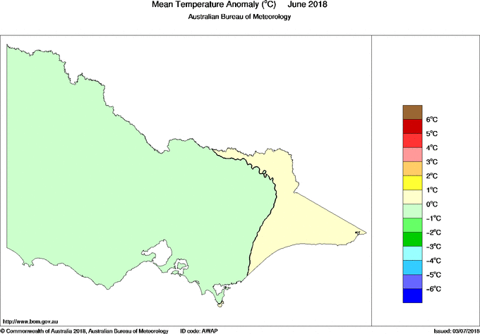
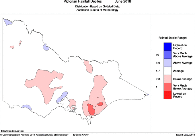
A bit early to be writing off winter though? June was slightly below average for temps across most of Victoria, and most of Victoria had average to above average rainfall. Fits with what 'feels' like a normal winter to me. Today was mild (relatively speaking) but we get a pre frontal day like this at least a couple of times each winter. And we are only 5 days in to July?
A bit early to be writing off winter though? June was slightly below average for temps across most of Victoria, and most of Victoria had average to above average rainfall. Fits with what 'feels' like a normal winter to me. Today was mild (relatively speaking) but we get a pre frontal day like this at least a couple of times each winter. And we are only 5 days in to July?
- Sean
- Supercell
- Reactions:
- Posts: 1000
- Joined: Mon Feb 27, 2012 6:35 pm
- Location: Patterson Lakes - SE Melb
Re: Series of fronts ending with cold outbreak: July 3-12
Gordon wrote: ↑Thu Jul 05, 2018 7:49 pm Yes a frustrating rainband literally sliding past our doorstep.
A bit early to be writing off winter though? June was slightly below average for temps across most of Victoria, and most of Victoria had average to above average rainfall. Fits with what 'feels' like a normal winter to me. Today was mild (relatively speaking) but we get a pre frontal day like this at least a couple of times each winter. And we are only 5 days in to July?
It's the freezing nights and sunny days that are making it odd. Winter rain is generally a succession of fronts that reduce freezing nights. Instead of dribs and drabs, we've had a few systems that helped us scrape by rain-wise, but allowing for all these freezing nights.
I won't write off winter just yet, but the possible El Nino might (rain-wise, at least).
All this has been good for the snow pack, but these high pressure systems are suppressing frontal systems, causing them to just scrape southern Victoria. But while Vic has managed to scrape by, and see average rain in places, NSW is doing it tough. Cold fronts just aren't reaching them. Western and southern areas of NSW should be plains of green right now instead of bare dirt.
-
hillybilly
- Site Admin/Moderator
- Reactions:
- Posts: 4980
- Joined: Thu Nov 26, 2009 7:26 am
- Location: Howden Tasmania, 25m above sea level
- Contact:
Re: Series of fronts ending with cold outbreak: July 3-12
Just don’t like the look of the progs. Looks and feels really El Niño like atm. Reminds me a lot of years like 2002, 2006 and 2009. In many of these spring hits with a bang in August. June was basically one rain event. Gut feeling is that we’ve got only another month before spring hits with a bangA bit early to be writing off winter though? June was slightly below average for temps across most of Victoria, and most of Victoria had average to above average rainfall. Fits with what 'feels' like a normal winter to me. Today was mild (relatively speaking) but we get a pre frontal day like this at least a couple of times each winter. And we are only 5 days in to July
- StratoBendigo
- Supercell
- Reactions:
- Posts: 2809
- Joined: Fri Jan 02, 2015 2:18 pm
- Location: Kangaroo Flat
Re: Series of fronts ending with cold outbreak: July 3-12
Or we could end up with another 1994 (which was an ElNino year). Similar feel to this year - good snow in June, lean July, then perhaps a cold and damp August-September?
Anyway, the weekend's cold front is looking to be reasonably cold, albeit short-lived.
Anyway, the weekend's cold front is looking to be reasonably cold, albeit short-lived.
- jimmyay
- Cumulonimbus
- Reactions:
- Posts: 163
- Joined: Thu Dec 13, 2012 2:33 pm
- Location: Port Melbourne
Re: Series of fronts ending with cold outbreak: July 3-12
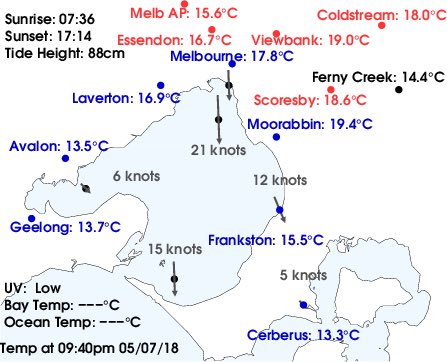
Bizarre. 19.4 degrees in Moorabbin Airport at the moment. It’s been warming up all evening. Will it crack 20.....
-
hillybilly
- Site Admin/Moderator
- Reactions:
- Posts: 4980
- Joined: Thu Nov 26, 2009 7:26 am
- Location: Howden Tasmania, 25m above sea level
- Contact:
Re: Series of fronts ending with cold outbreak: July 3-12
Not quiteBizarre. 19.4 degrees in Moorabbin Airport at the moment. It’s been warming up all evening. Will it crack 20.....
The one record that did fall was Sydney which had its warmest day for first week of July.
Some showers today and windy. Continuing quite mild but slowly cooling. Raining in the alps currently, but looks like snow levels will soon start to drop
Here’s Janes screen shot from 9.40.
- Tassiedave
- Supercell
- Reactions:
- Posts: 1098
- Joined: Thu Nov 11, 2010 11:09 am
- Location: Grindelwald Tasmania
Re: Series of fronts ending with cold outbreak: July 3-12
Rainfall since 9am Thurs: Pine Tree Rivulet 74mm, Mt Victoria 37mm, Sheffield 33mm, Deloraine 29mm, Cressy 28mm, Launceston 25mm, St Helens 7.2 mm, Hobart 5mm
- Gordon
- Supercell
- Reactions:
- Posts: 2888
- Joined: Thu Jun 17, 2010 10:01 am
- Location: Near Gordon, Vic. 620 m asl
Re: Series of fronts ending with cold outbreak: July 3-12
Finally raining properly here after several false starts! Temp 6C.
Some good falls out west; e.g. Mt William on 20mm.
Some good falls out west; e.g. Mt William on 20mm.
- Macedonian
- Supercell
- Reactions:
- Posts: 2330
- Joined: Mon Dec 21, 2009 10:44 pm
- Location: Mount Macedon Vic at 870m above sea level
Re: Series of fronts ending with cold outbreak: July 3-12
Temp dipped to 3.6C at mine around 11am. Nice to feel the chill again after yesterdays warmth. I recorded a 10.1C max yesterday. I usually never see a double digit temp at all in July. Doubly odd that yesterdays 10.1 was at 9.30pm
Home- "Shepherd's Bush" at Mt Macedon. 870m
Work- "Bolobek" at Macedon. 430m
Work- "Bolobek" at Macedon. 430m
- StratoBendigo
- Supercell
- Reactions:
- Posts: 2809
- Joined: Fri Jan 02, 2015 2:18 pm
- Location: Kangaroo Flat
Re: Series of fronts ending with cold outbreak: July 3-12
No rain today. Just dry dry dry. I reckon we might get nothing tomorrow too.
-
Didjman

- Supercell
- Reactions:
- Posts: 2099
- Joined: Fri Sep 03, 2010 2:52 pm
- Location: Wallan, Vic 328m ASL
- Contact:
Re: Series of fronts ending with cold outbreak: July 3-12
That Southerly Buster is just appearing on Mt Gambier radar 200klms to the SW. Looks good on satpic.
It is fair hiking!! Was deep in Southern Ocean this morning
It is fair hiking!! Was deep in Southern Ocean this morning
-
hillybilly
- Site Admin/Moderator
- Reactions:
- Posts: 4980
- Joined: Thu Nov 26, 2009 7:26 am
- Location: Howden Tasmania, 25m above sea level
- Contact:
Re: Series of fronts ending with cold outbreak: July 3-12
Another 0.8mm here today, so had 4.2mm for the date range. But, suspect we've had that evaporate plus more 
Hoping for tomorrow to surprise. It looks showery, but we need about 50mm in the next week just to keep with the average. Be mighty surprised if that happens
Lots of near misses on record heat to our north. Sydney Ap almost broke it's July record set just last year. Quite a few small fires in NSW with the gusty winds and warmth.
Snow starting to pile up in the alps now as the colder air moves in.
Awesome to see those totals Dave. Shame most of Vic missed this one. Classic winter rainband which really fills the soils, creeks and dams.Rainfall since 9am Thurs: Pine Tree Rivulet 74mm, Mt Victoria 37mm, Sheffield 33mm, Deloraine 29mm, Cressy 28mm, Launceston 25mm, St Helens 7.2 mm, Hobart 5mm
-
hillybilly
- Site Admin/Moderator
- Reactions:
- Posts: 4980
- Joined: Thu Nov 26, 2009 7:26 am
- Location: Howden Tasmania, 25m above sea level
- Contact:
Re: Series of fronts ending with cold outbreak: July 3-12
Zilch here overnight. Unbelievable. Cracking front moving up on Mt Gambier overnight died somewhere west of us slipping south.
Cold dry gusty nwly winds outside.
Cold dry gusty nwly winds outside.
- Skywalker
- Supercell
- Reactions:
- Posts: 1871
- Joined: Sun Nov 29, 2009 10:03 am
- Location: Burnside Heights/Cowes (Home) & Sunshine West (Work)
Re: Series of fronts ending with cold outbreak: July 3-12
Classic winter's morning here with the arriving of the front. Wet, windy & currently sitting on 8C with just over 1mm falling so far.
Caroline Springs, Melbourne's meteorological boredom zone.
- snowfall
- Supercell
- Reactions:
- Posts: 1284
- Joined: Mon Mar 20, 2017 7:39 pm
- Location: Gisborne South (349m asl)
Re: Series of fronts ending with cold outbreak: July 3-12
Sitting on 3.5mm for the thread. A few showers about this morning, but I doubt we'll see big totals. Quite cold though - we're on 6c and feeling very brisk with the wind.
-
hillybilly
- Site Admin/Moderator
- Reactions:
- Posts: 4980
- Joined: Thu Nov 26, 2009 7:26 am
- Location: Howden Tasmania, 25m above sea level
- Contact:
Re: Series of fronts ending with cold outbreak: July 3-12
Reports of snow in Trentham. Must be snow about top of Macedon. Dry air below showers will allow snow to fall to about 3C, maybe locally 4C. Lots of bright banding on radar which highlight snow flakes and also inflates the rain echoes.
5C here with a few spots. Some showers look to be lining us up over the Bay.
5C here with a few spots. Some showers look to be lining us up over the Bay.
- Tassiedave
- Supercell
- Reactions:
- Posts: 1098
- Joined: Thu Nov 11, 2010 11:09 am
- Location: Grindelwald Tasmania
Re: Series of fronts ending with cold outbreak: July 3-12
Rain from 9am Fri: Cradle Mt 48mm, Strathgordon 39mm, Mt Victoria 31mm, Mt Barrow 17mm, Smithton 16mm, Scottsdale 15mm, Devonport 12mm, Launceston 7.6mm, Hobart 5.8mm
- Macedonian
- Supercell
- Reactions:
- Posts: 2330
- Joined: Mon Dec 21, 2009 10:44 pm
- Location: Mount Macedon Vic at 870m above sea level
Re: Series of fronts ending with cold outbreak: July 3-12
Nice to see some snow falling here. First time this winter. 1.8C now.
Home- "Shepherd's Bush" at Mt Macedon. 870m
Work- "Bolobek" at Macedon. 430m
Work- "Bolobek" at Macedon. 430m