We are currently getting smashed by that same cell. Backyard path is flooded. Will check gauge soon.

Welcome New Members! We want to hear from you. Register, stop lurking and start posting!
VIC: Summery & unstable (Part 1) - November 9-19 2017
- Skywalker
- Supercell
- Reactions:
- Posts: 1871
- Joined: Sun Nov 29, 2009 10:03 am
- Location: Burnside Heights/Cowes (Home) & Sunshine West (Work)
Re: VIC: Summery & unstable weather - November 9-??? 2017
Caroline Springs, Melbourne's meteorological boredom zone.
-
mick

- Supercell
- Reactions:
- Posts: 1453
- Joined: Mon Nov 30, 2009 6:45 pm
- Location: Mid North SA Baaaaaaaaaaaaaaa
Re: VIC: Summery & unstable weather - November 9-??? 2017
Its because I moved, you all owe me thanks for taking one for the team.Hunter1890 wrote: ↑Sat Nov 18, 2017 4:31 pm Absolutely teeming down here in the north east. Haven't seen anything quite like it for some time. Keeps developing too. This is a BIG arvo for Melbourne
- stevco123
- Supercell
- Reactions:
- Posts: 2936
- Joined: Sat Aug 07, 2010 7:42 pm
- Location: Cranbourne 78m asl
Re: VIC: Summery & unstable weather - November 9-??? 2017
We have a storm now down here. Lightning and then half a second later...BAAANNGGGG!! Loudest thunder in a while.
https://www.weatherlink.com/bulletin/53 ... 76dd68e8bc: for current weather updated every 2 minutes
- Dane
- Supercell
- Reactions:
- Posts: 1661
- Joined: Thu Nov 26, 2009 9:51 am
- Location: Sebastopol 420m ASL
- Contact:
Re: VIC: Summery & unstable weather - November 9-??? 2017
Out of the Blue a small cell developed right over Cranny. We have rain and we have Thunder. 
Re: VIC: Summery & unstable weather - November 9-??? 2017
Unreal event for the CBD my wife is spending the weekend shopping with friends and just called me for some information!
Might be a bit far south in Geelong but this one is not failing to surprise. Still a seabreaze here which I must admit has died in the last 15 mins..... Might get to Lara. Last few frames has the main activity slightly swinging south again from what I can see.
Good read everyone Stay safe! - My wife tells me the CBD is a mess but don't know much more. I'm sure the news services will be taking care of that....... This time they probably CAN talk it up!
- Skywalker
- Supercell
- Reactions:
- Posts: 1871
- Joined: Sun Nov 29, 2009 10:03 am
- Location: Burnside Heights/Cowes (Home) & Sunshine West (Work)
Re: VIC: Summery & unstable weather - November 9-??? 2017
13mm here from that cell, rain still falling although it has eased right off.
Caroline Springs, Melbourne's meteorological boredom zone.
- Dane
- Supercell
- Reactions:
- Posts: 1661
- Joined: Thu Nov 26, 2009 9:51 am
- Location: Sebastopol 420m ASL
- Contact:
Re: VIC: Summery & unstable weather - November 9-??? 2017
Got a whopping half a mm from that cell before it moved away to the west and developed a bit more.
Thunder on 4 of the last 5 days here but not very much rain. MTD now 16.4 mm's
Thunder on 4 of the last 5 days here but not very much rain. MTD now 16.4 mm's
-
hillybilly

- Site Admin/Moderator
- Reactions:
- Posts: 4980
- Joined: Thu Nov 26, 2009 7:26 am
- Location: Howden Tasmania, 25m above sea level
- Contact:
Re: VIC: Summery & unstable weather - November 9-??? 2017
23mm in FC. Torrential. Cluster of 15 to 30mm falls locally. Local aws is blocked, so will take a while to catch up.
Down at Mornington watching it. Stunned by structure. Will upload photo. Lots of sparks here and brief heavy rain.
Down at Mornington watching it. Stunned by structure. Will upload photo. Lots of sparks here and brief heavy rain.
-
typhoon29

- Cumulonumbus Calvas
- Reactions:
- Posts: 510
- Joined: Fri Jan 01, 2010 11:05 pm
- Location: Ballarat (Mitchell Park)
- Contact:
Re: VIC: Summery & unstable weather - November 9-??? 2017
storms are all around us here but no hits. We won our cricket just before it all came in but yeah dry, windy
Ballarat, Home of the Anti-Thunderstorm Shield!
- Gordon
- Supercell
- Reactions:
- Posts: 2888
- Joined: Thu Jun 17, 2010 10:01 am
- Location: Near Gordon, Vic. 620 m asl
Re: VIC: Summery & unstable weather - November 9-??? 2017
15mm here from the storm just finishing now, so 45mm for thread to date which is great.
Locally lots of 15-30mm falls from that storm alone - we were at the lower end!
Locally lots of 15-30mm falls from that storm alone - we were at the lower end!
- snowfall
- Supercell
- Reactions:
- Posts: 1284
- Joined: Mon Mar 20, 2017 7:39 pm
- Location: Gisborne South (349m asl)
Re: VIC: Summery & unstable weather - November 9-??? 2017
Picked up 8mm from two storms, but looks like there much heavier falls not too far down the road. That takes us up to 39mm for the thread.
-
hillybilly
- Site Admin/Moderator
- Reactions:
- Posts: 4980
- Joined: Thu Nov 26, 2009 7:26 am
- Location: Howden Tasmania, 25m above sea level
- Contact:
Re: VIC: Summery & unstable weather - November 9-??? 2017
24mm in the manual gauge so event on 43mm. That's above what I expected so a good result. MTD is nearly 70mm so tracking ok.
Very patchy falls locally. Spots about 5km south only got a mm or two, while the area just east of us got smashed with big washouts and the local creek flowing a torrent. Looks like 40mm or more out there.
This warm humid weather just rolls on. Tomorrow is touch and go. It is most likely we will miss out on central areas with the instability confined to the southwest and northeast, with a weak inversion pushing in, but a chance. Similar on Monday. Showers and storms a bit more widespead from Tuesday.
Do we keep this thread going or start again??
Btw got a couple of photos. Will link later.
- Gordon
- Supercell
- Reactions:
- Posts: 2888
- Joined: Thu Jun 17, 2010 10:01 am
- Location: Near Gordon, Vic. 620 m asl
Re: VIC: Summery & unstable weather - November 9-??? 2017
Probably time for a new thread I think? Looks like a slight break for few days for western and central. 9th to 18th is quite a thread and it's gone out with a bang!
- Tassiedave
- Supercell
- Reactions:
- Posts: 1098
- Joined: Thu Nov 11, 2010 11:09 am
- Location: Grindelwald Tasmania
Re: VIC: Summery & unstable weather - November 9-??? 2017
Maximum temperatures yesterday Hobart 29.8 Melbourne 28.1 Perth 24.1 Adelaide 23.0 Sydney 22.6 Brisbane 20.4 Canberra 19.0. Not for the first time recently Hobart was the warmest non Darwin capital!
-
hillybilly
- Site Admin/Moderator
- Reactions:
- Posts: 4980
- Joined: Thu Nov 26, 2009 7:26 am
- Location: Howden Tasmania, 25m above sea level
- Contact:
Re: VIC: Summery & unstable weather - November 9-??? 2017
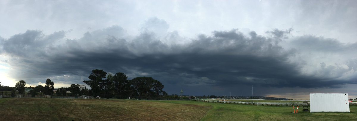
Photo from yesterday looking north form Mornington Race Course. Was throwing out lots of sparks. Rain drops under it we're huge, but looks to have missed the gauge network.
Isolated shower and storms today, mainly northeast ranges and southwest Victoria.
Isolated shower and storms today, mainly northeast ranges and southwest Victoria.
- StratoBendigo
- Supercell
- Reactions:
- Posts: 2809
- Joined: Fri Jan 02, 2015 2:18 pm
- Location: Kangaroo Flat
Re: VIC: Summery & unstable weather - November 9-??? 2017
We've missed out since Thursday AM. But hints of some more rain this coming Friday+Saturday. And potentially quite a bit too.
Unrelenting warmth and humidity in the lead up. Sydney weather in Vic....
Unrelenting warmth and humidity in the lead up. Sydney weather in Vic....
- Jake Smethurst
- Supercell
- Reactions:
- Posts: 3583
- Joined: Mon Nov 23, 2009 8:49 pm
- Location: Cheltenham
Re: VIC: Summery & unstable weather - November 9-??? 2017
We’re going to keep this thread open and running. It’s quite a unique period with humid and unstable conditions across the state so it’ll be good to collate everything in one place.
Left the city at 3pm yesterday after work, very much regretted that decision not long later as we had hardly anything in Cheltenham. Managed to see a few CGs, but the entire afternoon we spent quite literally on the edge of everything. A little disappointing but it was great to see plenty of storm action on radar and the severe weather it produced elsewhere.
As for today, risk diminishes somewhat, but focus will be about the southwest (mainly otways), extending across southern parts of the central district and into the Gippsland ranges area.
Jake - Senior AWF Forecaster
Feel free to send me a private message if you have any questions.
Feel free to send me a private message if you have any questions.
- Jake Smethurst
- Supercell
- Reactions:
- Posts: 3583
- Joined: Mon Nov 23, 2009 8:49 pm
- Location: Cheltenham
Re: VIC: Summery & unstable weather - November 9-??? 2017
VICTORIA THUNDERSTORM FORECAST - DAY 1
Sunday 19th November 2017
No proper graphic again today, further improvisation by using radar map. Much more stable conditions across the state today compared to yesterday due to warming uppers and a weakening trigger. Despite this, marginal instability exists across the southwest and parts of southern central districts, extending across the eastern ranges. If there is enough surface heating or convergence/forcing within these areas (“green” boundary region), then a few isolated thunderstorms may develop this afternoon and early evening. Due to enhanced moisture levels, any thunderstorm that does develop is likely to produce heavy rainfall. Large hail and damaging winds are less likely. For Melbourne, there is a risk, although only very small (less than 5%).
- B4290230-6ECB-4ACD-8811-A9E0B8B7D737.jpeg (841.13 KiB) Viewed 8491 times
Jake - Senior AWF Forecaster
Feel free to send me a private message if you have any questions.
Feel free to send me a private message if you have any questions.
-
typhoon29
- Cumulonumbus Calvas
- Reactions:
- Posts: 510
- Joined: Fri Jan 01, 2010 11:05 pm
- Location: Ballarat (Mitchell Park)
- Contact:
Re: VIC: Summery & unstable weather - November 9-??? 2017
Zero chance here too nice a day.
Ballarat, Home of the Anti-Thunderstorm Shield!
- Tassiedave
- Supercell
- Reactions:
- Posts: 1098
- Joined: Thu Nov 11, 2010 11:09 am
- Location: Grindelwald Tasmania
Re: VIC: Summery & unstable weather - November 9-??? 2017
The forecast maximum temperatures for Launceston over the next 7 days are all 27 and above. If this comes off we will smash our November Mean temperature record. Record is 22.5 way back in 2007 ( we are already 22.3).