
Welcome New Members! We want to hear from you. Register, stop lurking and start posting!
VIC: Low Pressure System: 3rd-10th September 2017
-
Rivergirl

- Memorial
- Reactions:
- Posts: 3674
- Joined: Sun Nov 22, 2009 6:04 pm
- Location: Ferny Creek VIC
- Contact:
Re: Low Pressure System: 3rd September -
I was in Upper Ferntree Gully at 2.10pm with blobs of frozen snow on my windscreen
-
dagget

- Cumulonimbus
- Reactions:
- Posts: 480
- Joined: Sun Nov 29, 2009 10:35 pm
- Location: Trentham (705m ASL)
Re: Low Pressure System: 3rd September -
More snow here and 3.7C, would be nice if it wasn't for that wind
- Skywalker
- Supercell
- Reactions:
- Posts: 1871
- Joined: Sun Nov 29, 2009 10:03 am
- Location: Burnside Heights/Cowes (Home) & Sunshine West (Work)
Re: Low Pressure System: 3rd September -
Obviously sweet bugger all happening here in the boredom zone. 
Caroline Springs, Melbourne's meteorological boredom zone.
- stevco123
- Supercell
- Reactions:
- Posts: 2936
- Joined: Sat Aug 07, 2010 7:42 pm
- Location: Cranbourne 78m asl
Re: Low Pressure System: 3rd September -
You're not the only one. Had two massive blobs of rain on the radar coming for a direct hit, only for them to dissipate whilst crossing the bay
https://www.weatherlink.com/bulletin/53 ... 76dd68e8bc: for current weather updated every 2 minutes
- BringOnTheCoolChange
- Cumulonimbus
- Reactions:
- Posts: 216
- Joined: Fri Jul 18, 2014 9:27 pm
- Location: East Warburton, Victoria, asl 232m
Re: Low Pressure System: 3rd September -
Anyone ever recall of much snow down here near Tremont? I have only been living here a few years. And can say at times Upwey has been more luckier than here. 
- Macedonian
- Supercell
- Reactions:
- Posts: 2330
- Joined: Mon Dec 21, 2009 10:44 pm
- Location: Mount Macedon Vic at 870m above sea level
Re: Low Pressure System: 3rd September -
Blizzarding down up here 
Home- "Shepherd's Bush" at Mt Macedon. 870m
Work- "Bolobek" at Macedon. 430m
Work- "Bolobek" at Macedon. 430m
- BringOnTheCoolChange
- Cumulonimbus
- Reactions:
- Posts: 216
- Joined: Fri Jul 18, 2014 9:27 pm
- Location: East Warburton, Victoria, asl 232m
Re: Low Pressure System: 3rd September -
3c here now, just need some precipitation, grrr 
- stevco123
- Supercell
- Reactions:
- Posts: 2936
- Joined: Sat Aug 07, 2010 7:42 pm
- Location: Cranbourne 78m asl
Re: Low Pressure System: 3rd September -
So what time is the coldest air supposed to come through?
Jane Bunn was saying on TV there are credible reports of it snowing at Rye.
Jane Bunn was saying on TV there are credible reports of it snowing at Rye.
https://www.weatherlink.com/bulletin/53 ... 76dd68e8bc: for current weather updated every 2 minutes
- BringOnTheCoolChange
- Cumulonimbus
- Reactions:
- Posts: 216
- Joined: Fri Jul 18, 2014 9:27 pm
- Location: East Warburton, Victoria, asl 232m
Re: Low Pressure System: 3rd September -
Which is hard to believe, when there still isn't any snow here. Just unlucky i guess. Looking at the Bom snow map, it looks like the coldest air is at 10pm - 1am
- stevco123
- Supercell
- Reactions:
- Posts: 2936
- Joined: Sat Aug 07, 2010 7:42 pm
- Location: Cranbourne 78m asl
Re: Low Pressure System: 3rd September -
Why is it that literally ALL the showers die before crossing over from geelong?
It is really starting to pee me off.
It is really starting to pee me off.
https://www.weatherlink.com/bulletin/53 ... 76dd68e8bc: for current weather updated every 2 minutes
- BringOnTheCoolChange
- Cumulonimbus
- Reactions:
- Posts: 216
- Joined: Fri Jul 18, 2014 9:27 pm
- Location: East Warburton, Victoria, asl 232m
Re: Low Pressure System: 3rd September -
stevco i reckon the weather just doesn't like you or me haha, there is rain on the radar directly above me atm, nothing is falling out of the sky, and any thing that falls should fall as snow from now around Tremont, maybe even Upwey.
- Sean
- Supercell
- Reactions:
- Posts: 1000
- Joined: Mon Feb 27, 2012 6:35 pm
- Location: Patterson Lakes - SE Melb
Re: Low Pressure System: 3rd September -
I think they're literally exhausting themselves, there's just not much moisture to go around.
The BOM were right on the money down this way, shower or two and 12c... Have had two showers and it reached 12c.
Last edited by Sean on Mon Sep 04, 2017 6:52 pm, edited 1 time in total.
- stevco123
- Supercell
- Reactions:
- Posts: 2936
- Joined: Sat Aug 07, 2010 7:42 pm
- Location: Cranbourne 78m asl
Re: Low Pressure System: 3rd September -
I always think there is some negative energy around me when it comes to weather. It just seems to avoid me.BringOnTheCoolChange wrote: ↑Mon Sep 04, 2017 6:43 pm stevco i reckon the weather just doesn't like you or me haha, there is rain on the radar directly above me atm, nothing is falling out of the sky, and any thing that falls should fall as snow from now around Tremont, maybe even Upwey.
https://www.weatherlink.com/bulletin/53 ... 76dd68e8bc: for current weather updated every 2 minutes
- BringOnTheCoolChange
- Cumulonimbus
- Reactions:
- Posts: 216
- Joined: Fri Jul 18, 2014 9:27 pm
- Location: East Warburton, Victoria, asl 232m
Re: Low Pressure System: 3rd September -
stevco123 wrote: ↑Mon Sep 04, 2017 6:50 pmI always think there is some negative energy around me when it comes to weather. It just seems to avoid me.BringOnTheCoolChange wrote: ↑Mon Sep 04, 2017 6:43 pm stevco i reckon the weather just doesn't like you or me haha, there is rain on the radar directly above me atm, nothing is falling out of the sky, and any thing that falls should fall as snow from now around Tremont, maybe even Upwey.
We should both move to Canada and we wouldn't have this problem haha.
- snowfall
- Supercell
- Reactions:
- Posts: 1283
- Joined: Mon Mar 20, 2017 7:39 pm
- Location: Gisborne South (349m asl)
Re: Low Pressure System: 3rd September -
I wasn't here today, so may have missed a few flurries. Currently 4c, so not really cold enough, unless the shower is heavy or low humidity, as appears to have been the case today in the Dandenongs. Not much showing up on the radar at the moment, but hoping something will turn up later tonight. Had 1.9mm of rain today.
- Macedonian
- Supercell
- Reactions:
- Posts: 2330
- Joined: Mon Dec 21, 2009 10:44 pm
- Location: Mount Macedon Vic at 870m above sea level
Re: Low Pressure System: 3rd September -
- 20170904_164315.jpg (1.21 MiB) Viewed 9897 times
Home- "Shepherd's Bush" at Mt Macedon. 870m
Work- "Bolobek" at Macedon. 430m
Work- "Bolobek" at Macedon. 430m
-
Didjman

- Supercell
- Reactions:
- Posts: 2099
- Joined: Fri Sep 03, 2010 2:52 pm
- Location: Wallan, Vic 328m ASL
- Contact:
Re: Low Pressure System: 3rd September -
Kewl pic Macedonian! 2C here now - oh for some precip!
Peter
Peter
-
hillybilly

- Site Admin/Moderator
- Reactions:
- Posts: 4979
- Joined: Thu Nov 26, 2009 7:26 am
- Location: Howden Tasmania, 25m above sea level
- Contact:
Re: Low Pressure System: 3rd September -
2.9C in FC and slowly dropping. Looks like a frustrating night. Showers mainly hugging the coast.
Dry air and westerlies are all too common with the coldest airmass in Melbourne. Seen so many low level snow events go like this (including the cracking events in 2014, 2005 and 1997 which were each cold enough for snow to sea level). Wouldn't write tonight off yet, but just too westerly ATM. It should slowly turn more southerly through the night, but showers look like mainly staying near the coast until morning.
Solid front tomorrow arvo will kick of lots of showers, but by then the snow level will be pushing up towards 800m.
- Gordon
- Supercell
- Reactions:
- Posts: 2888
- Joined: Thu Jun 17, 2010 10:01 am
- Location: Near Gordon, Vic. 620 m asl
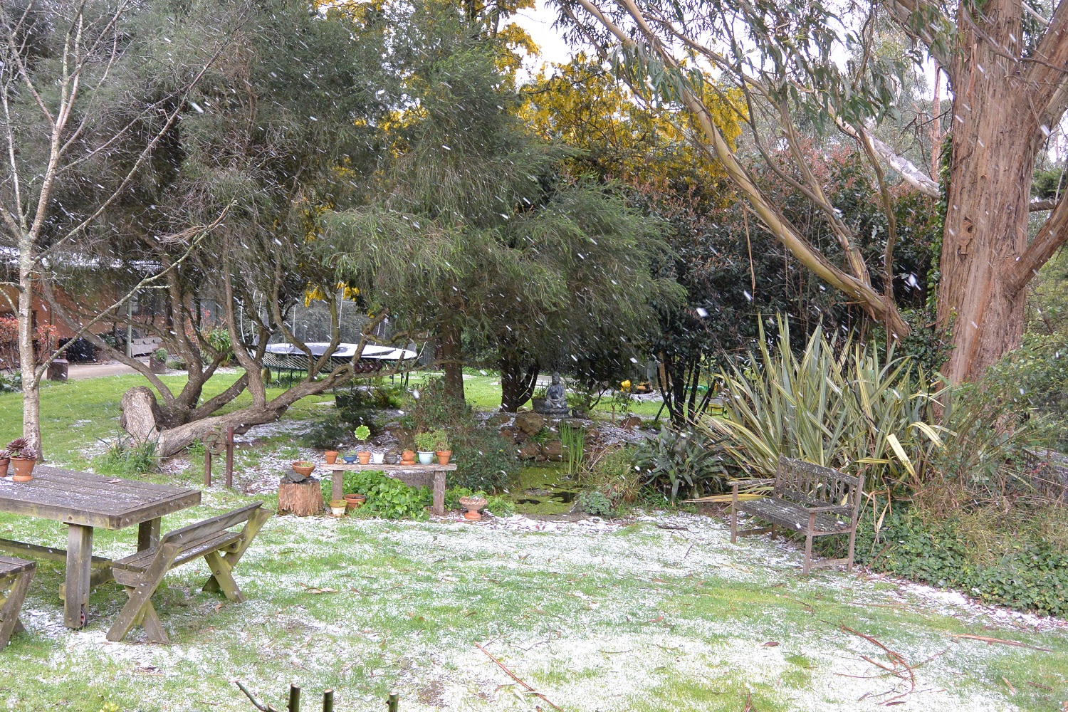
Re: Low Pressure System: 3rd September -
Today's snow - it settled for half an hour or so around mid afternoon. Unfortunately the wind was blowing so hard, it only accumulated in spots. Still, it means we can at least put down 2017 as another settled snow year - so we haven't missed for a long time.
-
dagget
- Cumulonimbus
- Reactions:
- Posts: 480
- Joined: Sun Nov 29, 2009 10:35 pm
- Location: Trentham (705m ASL)
Re: Low Pressure System: 3rd September -
2.5c and snowing again, should have a bit of a chance to settle.