Happy New Year !
Just putting in a thread to get the year started. Fairly mild start to the thread with a little easterly dip around Thursday that might give some convective showers across Vic, then some good summer heat to finish. Monsoonal activity is currently gathering pace again with a strong north to north western burst coming into the northern tropics from Indo..... one to watch closely.

Welcome New Members! We want to hear from you. Register, stop lurking and start posting!
Vic - Jan 1 to 8th - mild start, mid week easterly dip, hot finish
- JasmineStorm
- Supercell
- Reactions:
- Posts: 1870
- Joined: Thu Sep 22, 2016 9:40 pm
- Location: Kyneton 527 ASL
- JasmineStorm
- Supercell
- Reactions:
- Posts: 1870
- Joined: Thu Sep 22, 2016 9:40 pm
- Location: Kyneton 527 ASL
Re: Vic - Jan 1 to 8th - mild start, mid week easterly dip, hot finish
23c here today, I see down south the southerly is bringing in some light wet stuff.
The monsoon low lottery draw is about to get underway again with a low starting to crank in the N.T. Models have it moving SW towards the Kimberley by Monday and menacingly close to the coast like the last one. So its seems like another Landphoon and not a cyclone but who knows really. Again, it could drive our weather towards the end of this week with some good heat coming down. After that is a guess at the moment. Here is latest snap 850 hPa shot.... https://earth.nullschool.net/#current/w ... 889,-8.775
The monsoon low lottery draw is about to get underway again with a low starting to crank in the N.T. Models have it moving SW towards the Kimberley by Monday and menacingly close to the coast like the last one. So its seems like another Landphoon and not a cyclone but who knows really. Again, it could drive our weather towards the end of this week with some good heat coming down. After that is a guess at the moment. Here is latest snap 850 hPa shot.... https://earth.nullschool.net/#current/w ... 889,-8.775
- I_Love_Storms
- Supercell
- Reactions:
- Posts: 2812
- Joined: Wed Dec 02, 2009 2:01 pm
- Location: Hawthorn
Re: Vic - Jan 1 to 8th - mild start, mid week easterly dip, hot finish
Latest GFS has PW values around 60mm in SA and 45mm in Vic at the end of the run. A repeat of what we just had. EC has nothing at the moment
- Sean
- Supercell
- Reactions:
- Posts: 1000
- Joined: Mon Feb 27, 2012 6:35 pm
- Location: Patterson Lakes - SE Melb
Re: Vic - Jan 1 to 8th - mild start, mid week easterly dip, hot finish
Things tend to come in threes...I_Love_Storms wrote:Latest GFS has PW values around 60mm in SA and 45mm in Vic at the end of the run. A repeat of what we just had. EC has nothing at the moment
-
hillybilly

- Site Admin/Moderator
- Reactions:
- Posts: 4980
- Joined: Thu Nov 26, 2009 7:26 am
- Location: Howden Tasmania, 25m above sea level
- Contact:
Re: Vic - Jan 1 to 8th - mild start, mid week easterly dip, hot finish
EC gone from big falls to zilch  ACCESS and GFS both have some showers and storms around Thursday and with the front late Saturday/early Sunday. All agree on seasonally warm to hot conditions. Suspect more wiggles in the models with type troughs not particularly strong, but ok moisture.
- Tassiedave
- Supercell
- Reactions:
- Posts: 1098
- Joined: Thu Nov 11, 2010 11:09 am
- Location: Grindelwald Tasmania
Re: Vic - Jan 1 to 8th - mild start, mid week easterly dip, hot finish
Hobart has received 34.8 mm of rain since 9 am yesterday. Including 33 mm between 400 and 730. Campania in the South East has had 58 mm with 50 mm falling between 530 and 930.
- Gordon
- Supercell
- Reactions:
- Posts: 2888
- Joined: Thu Jun 17, 2010 10:01 am
- Location: Near Gordon, Vic. 620 m asl
Re: Vic - Jan 1 to 8th - mild start, mid week easterly dip, hot finish
Wow, those are big totals/rain rates for Hobart.
2mm here to start 2017 and surprisingly cool: just 9C at 10 am.
2mm here to start 2017 and surprisingly cool: just 9C at 10 am.
- Geoff
- Supercell
- Reactions:
- Posts: 2538
- Joined: Tue Jul 05, 2011 9:46 pm
- Location: Olinda VIC (470m ASL)
Re: Vic - Jan 1 to 8th - mild start, mid week easterly dip, hot finish
Not only wet with several thunderstorms but blowing a gale too. I spent last night near Port Arthur with my tent collapsed on top of me flapping about like a flag.
Vast improvement today at Bruny Island.
Vast improvement today at Bruny Island.
AWF Rainfall Details - Monthly rainfall stats. Please post your totals here at the end of each month, thank you –
http://www.theaustralianweatherforum.co ... &start=180
http://www.theaustralianweatherforum.co ... &start=180
- JasmineStorm
- Supercell
- Reactions:
- Posts: 1870
- Joined: Thu Sep 22, 2016 9:40 pm
- Location: Kyneton 527 ASL
Re: Vic - Jan 1 to 8th - mild start, mid week easterly dip, hot finish
A sunny but an unsummer like 19c here today. Looks grey south of the divide. Nice little upper trough for Tassie yesterday indeed.
Here’s what I can currently see on the latest models – The monsoon low in the N.T is off and running with some big rain totals around Darwin. It’s modelled by all models to track a similar path to the last landphoon at Christmas…..but let’s wait and see on that topic as those beasts have a mind of their own. If it’s moves slightly west, it’s a totally different cyclonic ball game. The easterly dip still looks likely on Thursday for some bubbling clouds / showers. In a nutshell, ATM it seems like 30+ for most of Vic from Wednesday to Sunday with a dry-ish front around Sunday lunchtime in central parts. Monsoon low is still an unknown x factor though.
Other notable longer term off topic mentions –
1. Volatile southern front Jan 15th meets tropical moisture over Vic.
2. CFS has modelled a heatwave for the 1st week of the Oz tennis open. You can also see this appearing on GFS with a monster high coming in.
3. CFS model still thinks a long fire season with less rain.
http://www.tropicaltidbits.com/analysis ... 0&ypos=432
http://www.tropicaltidbits.com/analysis ... 0&ypos=475
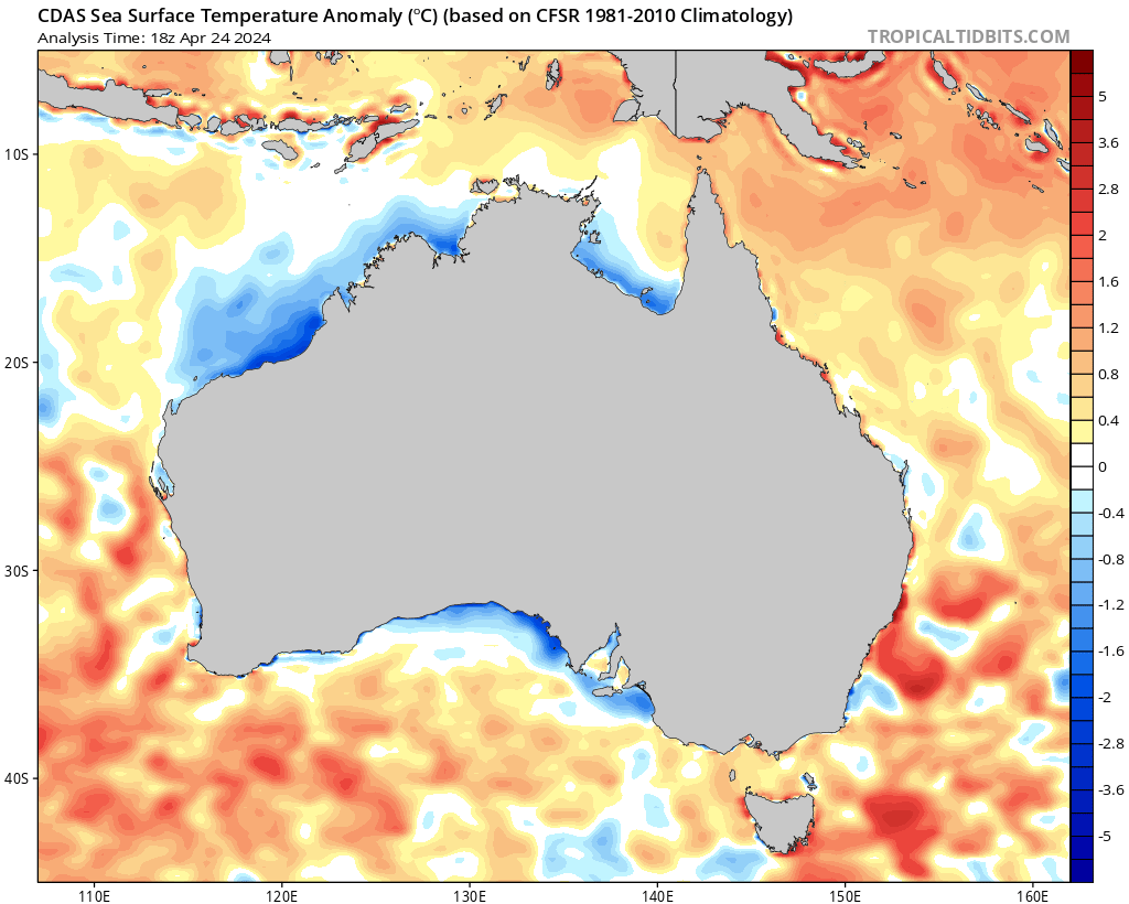
4. SE OZ water temps are nice and warm ATM. http://www.tropicaltidbits.com/analysis ... _aus_1.png
Here’s what I can currently see on the latest models – The monsoon low in the N.T is off and running with some big rain totals around Darwin. It’s modelled by all models to track a similar path to the last landphoon at Christmas…..but let’s wait and see on that topic as those beasts have a mind of their own. If it’s moves slightly west, it’s a totally different cyclonic ball game. The easterly dip still looks likely on Thursday for some bubbling clouds / showers. In a nutshell, ATM it seems like 30+ for most of Vic from Wednesday to Sunday with a dry-ish front around Sunday lunchtime in central parts. Monsoon low is still an unknown x factor though.
Other notable longer term off topic mentions –
1. Volatile southern front Jan 15th meets tropical moisture over Vic.
2. CFS has modelled a heatwave for the 1st week of the Oz tennis open. You can also see this appearing on GFS with a monster high coming in.
3. CFS model still thinks a long fire season with less rain.
http://www.tropicaltidbits.com/analysis ... 0&ypos=432
http://www.tropicaltidbits.com/analysis ... 0&ypos=475
4. SE OZ water temps are nice and warm ATM. http://www.tropicaltidbits.com/analysis ... _aus_1.png
- JasmineStorm
- Supercell
- Reactions:
- Posts: 1870
- Joined: Thu Sep 22, 2016 9:40 pm
- Location: Kyneton 527 ASL
Re: Vic - Jan 1 to 8th - mild start, mid week easterly dip, hot finish
Looks like the easterly dip will certainly get the clouds bubbling on Thursday afternoon according to GFS.
https://www.ventusky.com/?p=-37.23;144. ... 5/06&w=off
https://www.ventusky.com/?p=-37.23;144. ... 5/06&w=off
- JasmineStorm
- Supercell
- Reactions:
- Posts: 1870
- Joined: Thu Sep 22, 2016 9:40 pm
- Location: Kyneton 527 ASL
Re: Vic - Jan 1 to 8th - mild start, mid week easterly dip, hot finish
GFS thinks a moderate little heat wave from tomorrow. Chance of convective showers / storms still on the radar for Thursday. The remains of the landphoon to drift down into Vic by mid next week but a lot of water to go under the bridge before you can take that too serious IMO.
http://stormcast.com.au/stormcast.html? ... :null:0#sc
http://stormcast.com.au/stormcast.html? ... :null:0#sc
- Attachments
-
- GFS 030117 00z temps.jpg (43.8 KiB) Viewed 9664 times
Re: Vic - Jan 1 to 8th - mild start, mid week easterly dip, hot finish
Yes JS it looks to be typical, boring, average summer weather up ahead.
At least there are no extreme temps coming.
At least there are no extreme temps coming.
-
hillybilly
- Site Admin/Moderator
- Reactions:
- Posts: 4980
- Joined: Thu Nov 26, 2009 7:26 am
- Location: Howden Tasmania, 25m above sea level
- Contact:
Re: Vic - Jan 1 to 8th - mild start, mid week easterly dip, hot finish
Nice thick fog up here so a bit of moisture in the air.
GFS and ACCESS got a bit the next three days, having both upped totals. Chance of a shower for central and eastern areas today, spreading overnight. More showers tomorrow arvo and decent chance for a storm. Slight chance then on Friday. The instability indices look ok and the humidity is respectable with PW values around thirty to forty mm.
GFS and ACCESS got a bit the next three days, having both upped totals. Chance of a shower for central and eastern areas today, spreading overnight. More showers tomorrow arvo and decent chance for a storm. Slight chance then on Friday. The instability indices look ok and the humidity is respectable with PW values around thirty to forty mm.
- StratoBendigo
- Supercell
- Reactions:
- Posts: 2809
- Joined: Fri Jan 02, 2015 2:18 pm
- Location: Kangaroo Flat
Re: Vic - Jan 1 to 8th - mild start, mid week easterly dip, hot finish
The last couple of days and nights have been very comfortable. Wind now NE and humidity on the rise. But I don't think we'll see much rain in the coming days, especially after last week's non-event here.
But it's all happening across Northern Australia!
But it's all happening across Northern Australia!
- JasmineStorm
- Supercell
- Reactions:
- Posts: 1870
- Joined: Thu Sep 22, 2016 9:40 pm
- Location: Kyneton 527 ASL
Re: Vic - Jan 1 to 8th - mild start, mid week easterly dip, hot finish
Just doing an afternoon check of all the vitals
- Currently 31c and rising up here, Baro has slowly dropped 4 today. Dew Point up 6c now around 16c and Humidity 40% .
- Clouds are starting to bubble up here in the hills.
- The old seabreeze vs northerly battle is on again in Melbourne.
- Monsoon trough bombing the tropics. A lovely 300mm + in Mackay to water the gardens.
As HB mentioned, models keep lifting instability for today and tomorrow especially. Very good chance for sparks east of Melbourne this afternoon. I’ve got a feeling that mother nature might start a few fires tomorrow.
https://www.ventusky.com/?p=-37.51;144. ... 0170105/06
- JasmineStorm
- Supercell
- Reactions:
- Posts: 1870
- Joined: Thu Sep 22, 2016 9:40 pm
- Location: Kyneton 527 ASL
Re: Vic - Jan 1 to 8th - mild start, mid week easterly dip, hot finish
MetEye now on board for tomorrows possible storms / hail.
- Attachments
-
- MetEye 050117 2pm.jpg (135.57 KiB) Viewed 9320 times
- weathergasm
- Cumulonimbus
- Reactions:
- Posts: 244
- Joined: Sun Feb 14, 2010 9:32 pm
- Location: Box Hill
Re: Vic - Jan 1 to 8th - mild start, mid week easterly dip, hot finish
I am really surprised that tomorrow's forecast isn't generating more interest here. It's pretty rare for the BOM to forecast hail with a summer thunderstorm. Doesn't that indicate rather deep atmospheric instability?
-
typhoon29

- Cumulonumbus Calvas
- Reactions:
- Posts: 510
- Joined: Fri Jan 01, 2010 11:05 pm
- Location: Ballarat (Mitchell Park)
- Contact:
Re: Vic - Jan 1 to 8th - mild start, mid week easterly dip, hot finish
I saw that!!!weathergasm wrote:I am really surprised that tomorrow's forecast isn't generating more interest here. It's pretty rare for the BOM to forecast hail with a summer thunderstorm. Doesn't that indicate rather deep atmospheric instability?
wow if it comes off! Car yards lock your cars away!!! Must be a typo!
this is for Ballarat:
Thursday 5 January
Summary
Min 15
Max 30
Showers. Possible storm.
Possible rainfall: 1 to 4 mm
Chance of any rain: 80%
Partly cloudy. High (80%) chance of showers in the morning and afternoon. The chance of a thunderstorm, with possible hail in the afternoon and early evening. Winds northerly 25 to 40 km/h becoming light in the late afternoon then becoming east to southeasterly 15 to 20 km/h in the late evening.
Fire Danger - High
Ballarat, Home of the Anti-Thunderstorm Shield!
- JasmineStorm
- Supercell
- Reactions:
- Posts: 1870
- Joined: Thu Sep 22, 2016 9:40 pm
- Location: Kyneton 527 ASL
Re: Vic - Jan 1 to 8th - mild start, mid week easterly dip, hot finish
Nice little multicell cluster with CG's and anvil crawlers heading into the Ballarat area in the next hour 
- Dane
- Supercell
- Reactions:
- Posts: 1661
- Joined: Thu Nov 26, 2009 9:51 am
- Location: Sebastopol 420m ASL
- Contact:
Re: Vic - Jan 1 to 8th - mild start, mid week easterly dip, hot finish
Steering's not so good with those cells, they are mostly drifting to the NE so little chance of any
action in the southern suburbs where I live.
action in the southern suburbs where I live.