
Welcome New Members! We want to hear from you. Register, stop lurking and start posting!
Stretch of troughs with showers: October 25 to November 5?
- I_Love_Storms
- Supercell
- Reactions:
- Posts: 2812
- Joined: Wed Dec 02, 2009 2:01 pm
- Location: Hawthorn
Re: Stretch of troughs with showers: October 25 to November
Whiteout in Flemington
- I_Love_Storms
- Supercell
- Reactions:
- Posts: 2812
- Joined: Wed Dec 02, 2009 2:01 pm
- Location: Hawthorn
Re: Stretch of troughs with showers: October 25 to November
TOP PRIORITY FOR IMMEDIATE BROADCAST
SEVERE THUNDERSTORM WARNING - MELBOURNE AREA
for DESTRUCTIVE WIND, HEAVY RAINFALL, LARGE HAILSTONES and TORNADOES
For people in the Port Phillip, Inner East, Inner, South East, Western and parts of the Mornington Peninsula, Northern, Outer East and Geelong and Bellarine Peninsula Local Warning Areas.
Issued at 2:01 pm Thursday, 5 November 2015.
THIS INCLUDES A TORNADO WARNING.
The Bureau of Meteorology warns that, at 1:50 pm, very dangerous thunderstorms were detected on weather radar near Bulla. These thunderstorms are moving towards the south. Very dangerous thunderstorms are forecast to affect Melbourne Airport, St Albans, Sydenham and Williamstown by 2:20 pm and northern Port Phillip Bay, waters off Brighton beach, waters off Pt Cook and waters off Sandringham by 2:50 pm.
Destructive winds, heavy rainfall that may lead to flash flooding, large hailstones and tornadoes are likely.
Several reports of Tornadoes from Craigeburn, Campbellfied and Tullamarine area.
The State Emergency Service advises that people should:
* Keep clear of fallen power lines.
* secure any loose objects in the vicinity of your home.
* keep away from creeks and drains.
* do not drive vehicles through flooded areas.
* stay indoors if possible.
* Avoid using the phone during the storm.
* if you are outside, avoid sheltering under trees
* listen to the radio for storm updates
* switch off your computer and electrical appliances
The next warning is due to be issued by 3:05 pm.
A more general severe thunderstorm warning is also current for the Central, Northern Country, North Central, North East and parts of the Mallee, South West, West and South Gippsland and Wimmera districts.
Warnings are also available through TV and Radio broadcasts, the Bureau's website at http://www.bom.gov.au" onclick="window.open(this.href);return false; or call 1300 659 217. The Bureau and State Emergency Service would appreciate warnings being broadcast regularly.
- Jake Smethurst
- Supercell
- Reactions:
- Posts: 3583
- Joined: Mon Nov 23, 2009 8:49 pm
- Location: Cheltenham
Re: Stretch of troughs with showers: October 25 to November
Looking nice! Another unstable day out there, convection all over the place!
Unless there's development to the eastern side of these cells, then most of the eastern suburbs will miss this blob, but it should still move over bayside suburbs on the eastern side of the bay. I'm in the firing line
Unless there's development to the eastern side of these cells, then most of the eastern suburbs will miss this blob, but it should still move over bayside suburbs on the eastern side of the bay. I'm in the firing line
Jake - Senior AWF Forecaster
Feel free to send me a private message if you have any questions.
Feel free to send me a private message if you have any questions.
- WeatherViewer
- Cumulonimbus
- Reactions:
- Posts: 388
- Joined: Fri Oct 19, 2012 5:57 pm
- Location: Truganina
Re: Stretch of troughs with showers: October 25 to November
According to my station at home, it was right in the direct firing line again with those heavy cells out towards Werribee way.
Accumulated another 5mm, sitting at around 33mm for the day.
Accumulated another 5mm, sitting at around 33mm for the day.
- Lily
- Supercell
- Reactions:
- Posts: 4014
- Joined: Wed Nov 25, 2009 10:29 pm
- Location: Rowville/Lysterfield
Re: Stretch of troughs with showers: October 25 to November
Hello my lovelies
Trying to vacuum and in puddles of sweat, so giving up and coming online to watch the fun instead. Just over 16mm here so far since last night, sun is currently out with a few patches of blue even showing from a high, unstable overhead cloud base. Looks much more interesting to our NW horizon!
There really can be nothing more frustrating for a weather watcher than to watch storms just skim you by. Enjoy everyone who gets under it, look forward to your updates
- Jake Smethurst
- Supercell
- Reactions:
- Posts: 3583
- Joined: Mon Nov 23, 2009 8:49 pm
- Location: Cheltenham
Re: Stretch of troughs with showers: October 25 to November
VERY rare to see a tornado including in the warning! Will be interesting to watch this system.
I have to drive from Parkdale to Caulfield. This should be interesting.
I have to drive from Parkdale to Caulfield. This should be interesting.
Jake - Senior AWF Forecaster
Feel free to send me a private message if you have any questions.
Feel free to send me a private message if you have any questions.
- Skywalker
- Supercell
- Reactions:
- Posts: 1871
- Joined: Sun Nov 29, 2009 10:03 am
- Location: Burnside Heights/Cowes (Home) & Sunshine West (Work)
Re: Stretch of troughs with showers: October 25 to November
BANG!! Direct hit here at work. Complete white out. Looks like home has copped it as well.
Caroline Springs, Melbourne's meteorological boredom zone.
- stevco123
- Supercell
- Reactions:
- Posts: 2936
- Joined: Sat Aug 07, 2010 7:42 pm
- Location: Cranbourne 78m asl
Re: Stretch of troughs with showers: October 25 to November
I just read that warning again.
It actually says there have been several reports of tornados from Craigeburn, Campbellfied and Tullamarine area.
What the???
EDIT>>> The eastern metro has just exploded too.
Hold On!!
It actually says there have been several reports of tornados from Craigeburn, Campbellfied and Tullamarine area.
What the???
EDIT>>> The eastern metro has just exploded too.
Hold On!!
https://www.weatherlink.com/bulletin/53 ... 76dd68e8bc: for current weather updated every 2 minutes
-
occluded

- Cumulonumbus Calvas
- Reactions:
- Posts: 611
- Joined: Tue May 04, 2010 3:26 pm
- Location: Mooroolbark 130m asl
Re: Stretch of troughs with showers: October 25 to November
Whitehout and sheets of rain now in the CBD.
EDIT: water running in sheets down the office windows. Haven't seen that in quite a while.
Wall of rain seems to have appeared in the east now. West getting hammered againstevco123 » Thu Nov 05, 2015 1:00 pm wrote:stevco123 wrote:Hmmm, at this stage a bit touch and go on whether anything decent falls in the majority of the eastern 'burbs.
EDIT: water running in sheets down the office windows. Haven't seen that in quite a while.
- stevco123
- Supercell
- Reactions:
- Posts: 2936
- Joined: Sat Aug 07, 2010 7:42 pm
- Location: Cranbourne 78m asl
Re: Stretch of troughs with showers: October 25 to November
Currently in Scoresby, sky is BLACK to the north and northwest
https://www.weatherlink.com/bulletin/53 ... 76dd68e8bc: for current weather updated every 2 minutes
-
hillybilly

- Site Admin/Moderator
- Reactions:
- Posts: 4979
- Joined: Thu Nov 26, 2009 7:26 am
- Location: Howden Tasmania, 25m above sea level
- Contact:
Re: Stretch of troughs with showers: October 25 to November
Torrential in the city - flooding rain.
Here's a screen shot of the warning and a photo just before it hit.


EDIT> 59mm in Docklands, with about 45mm of that falling in about 20 minutes.
Here's a screen shot of the warning and a photo just before it hit.
EDIT> 59mm in Docklands, with about 45mm of that falling in about 20 minutes.
- Wilko
- Supercell
- Reactions:
- Posts: 1492
- Joined: Wed Aug 11, 2010 12:08 pm
- Location: Moorabbin & Highett, Vic
ReS: Stretch of troughs with showers: October 25 to November
about to smash us here in Moorabbin
Will report in about 20 minutes
Will report in about 20 minutes
Re: Stretch of troughs with showers: October 25 to November
More focused on this weather than my maths exam now!! Tornado reports!!
Go the bombersss!
- stevco123
- Supercell
- Reactions:
- Posts: 2936
- Joined: Sat Aug 07, 2010 7:42 pm
- Location: Cranbourne 78m asl
Re: Stretch of troughs with showers: October 25 to November
Nothing tooo dramatic here in Scoresby. Just heavy rain. Was kind of expecting more, but still happy with rain
https://www.weatherlink.com/bulletin/53 ... 76dd68e8bc: for current weather updated every 2 minutes
- Geoff
- Supercell
- Reactions:
- Posts: 2538
- Joined: Tue Jul 05, 2011 9:46 pm
- Location: Olinda VIC (470m ASL)
Re: Stretch of troughs with showers: October 25 to November
In Wantirna at the moment, just had a good old fashioned dumper here with a flanf thrown in too. Clearing now.
AWF Rainfall Details - Monthly rainfall stats. Please post your totals here at the end of each month, thank you –
http://www.theaustralianweatherforum.co ... &start=180
http://www.theaustralianweatherforum.co ... &start=180
- I_Love_Storms
- Supercell
- Reactions:
- Posts: 2812
- Joined: Wed Dec 02, 2009 2:01 pm
- Location: Hawthorn
Re: Stretch of troughs with showers: October 25 to November
The entire 512 radar is erupting north of the city, maybe round 3 later
- stevco123
- Supercell
- Reactions:
- Posts: 2936
- Joined: Sat Aug 07, 2010 7:42 pm
- Location: Cranbourne 78m asl
Re: Stretch of troughs with showers: October 25 to November
Scoresby had 5mm out of that, the site reckons. I could ahve sworn it was more the way it was coming down
This system is now heading for home (Cranbourne West), so I'll love to compare when it hits there.
Also, pics have surfaced of that tornado near tullamarine:
http://www.heraldsun.com.au/features/sp ... aed0d75a96" onclick="window.open(this.href);return false;
source herald sun
This system is now heading for home (Cranbourne West), so I'll love to compare when it hits there.
Also, pics have surfaced of that tornado near tullamarine:
http://www.heraldsun.com.au/features/sp ... aed0d75a96" onclick="window.open(this.href);return false;
source herald sun
https://www.weatherlink.com/bulletin/53 ... 76dd68e8bc: for current weather updated every 2 minutes
- Skywalker
- Supercell
- Reactions:
- Posts: 1871
- Joined: Sun Nov 29, 2009 10:03 am
- Location: Burnside Heights/Cowes (Home) & Sunshine West (Work)
Re: Stretch of troughs with showers: October 25 to November
Well that was fun. Heavy rain, flangs, thunder and the internet going down (Yes old copper technology will suit us just fine Mr Turnbull). 
Caroline Springs, Melbourne's meteorological boredom zone.
-
hillybilly
- Site Admin/Moderator
- Reactions:
- Posts: 4979
- Joined: Thu Nov 26, 2009 7:26 am
- Location: Howden Tasmania, 25m above sea level
- Contact:
Re: Stretch of troughs with showers: October 25 to November
14mm from that band in FC. Event up to 42mm (plus 21mm from the weekend).
- wolfcat
- Cumulonumbus Calvas
- Reactions:
- Posts: 562
- Joined: Sun Mar 07, 2010 12:14 pm
- Location: Bentleigh East
- Contact:
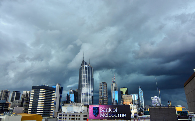
Re: Stretch of troughs with showers: October 25 to November
Just before it hit the city...
other places you will find me...
My blog...http://www.wolfcat.com.au/randomrants/
Flickr .. http://www.flickr.com/photos/wolfcat_aus/
Twitter... http://twitter.com/wolfcat
Redbubble... http://www.redbubble.com/people/wolfcat
My blog...http://www.wolfcat.com.au/randomrants/
Flickr .. http://www.flickr.com/photos/wolfcat_aus/
Twitter... http://twitter.com/wolfcat
Redbubble... http://www.redbubble.com/people/wolfcat