Ignoring anything useful from the cool change to sweep by on the weekend coming if I may.... the "out there" progs for GFS and EC next week have both played with the birth of a major inland low system. Born in N WA this potential inland system slowly gravitates SE'ward towards the Vic area mid week in a track that should advect plenty of moisture inland to Vic from the NE on its way.
What becomes of this moisture is too far out to determine, but plenty of it should be around!!
A more saner person than myself would think we would be due for a return to extended summer heat conditions.
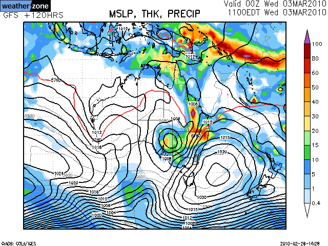
The high late this week is my worry, but hoping it forms further south like below tassie or east of tassie this will allow the monsoon low and trough to move Se in to SE Aus bringing great rain and storms to much of SE Aus which would be just great.
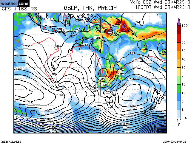
The Monsoon low and Trough in N Aus atm is huge, and looks great lots of rain and storms going on, and already into parts NE SA, and should hang there for the next 48 hours before moving south from Friday into our area by Saturday and Sunday
Lets just hope this high that is looking quite strong develops further south and gets to the tasmen quickly then stall that would be great for us
Man it would be great if that low could move down this way bringing with it rain and storms
What would be good though, is a Big thick heavy RAINBAND we haven't had one of those in ages be great if this system could do it but its ages away
Can't see this one coming off with poor timing in the LWT to the south if a developing ridge keeping things inland. The centre of AUS is going underwater.
Looks dry here pretty much the whole run with the blocking pattern. Nothing hot though.
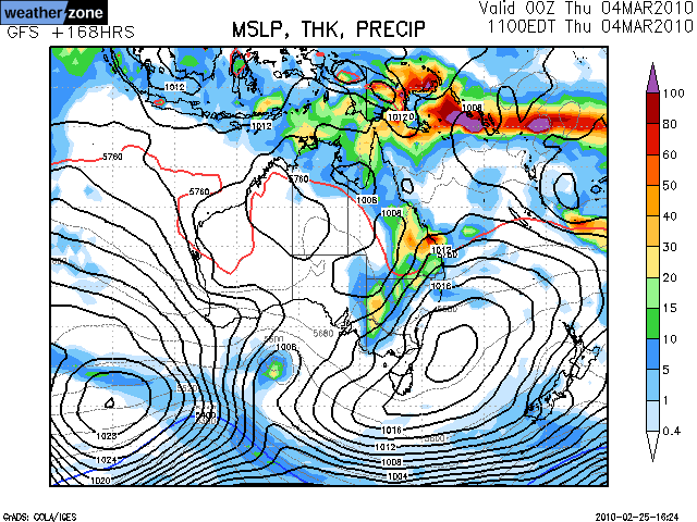
I like it next week even though models chop and change with this one the general consenus is that tropical low will develop and move into SE Australia and that should deposit enormous amount of moisture through NW of the Country and Central parts of the Country eventually sliding SE towards us as it hooks into the next Major Long Wave trough that comes in from the Bight later next week.
I know it's a fair way out, but I am starting to like this particular system as well. GFS showing the low to push south towards Victoria from Queensland in the latter part of it's model run as we have a large high slow-moving in the Tasman Sea. It is also good to see EC having a similar scenario in tonight's run for around next Wednesday/Thursday though. Expect some rather big falls if this system was to come off. Just a wait and see game at the moment considering it's so far out, but I have a good feeling about it at this stage.
Jake - Senior AWF Forecaster
Feel free to send me a private message if you have any questions.
Well US has developed the rainfall more broadly along a trough through our neck of the woods, extending into the low pressure system over the interior. Still has 300-500mm through C Australia. This is very similar to the path of Olga. And looking at the satellite, it does appear to have similar qualities.
At this stage it is still fairly marginal for VIC but we need a miracle run in the models to bring the low back and then down through our region.
I still think this event is likely to occur, but the general pattern is models chopping and changing and shifting the event to the last couple of days in the model runs. Mostly GFS at this stage on board, will have to keep an eye on the situation; I think the event will happen, just when is the question.
Jake - Senior AWF Forecaster
Feel free to send me a private message if you have any questions.
What gets more interest for next week is BOM rainfall land map continues to show good widespread rainfall across the state 20-50mm in most parts for the bulk of Victoria.. Now the fact EC isn't still onboard yet and GFS has the good falls mainly NE over Victoria and NSW makes me look inbetween the lines that other models must be still right onboard with this system and havent backed off hence the good widespread rainfall for Victoria which perhaps means EC may come back.. Seen this before if EC backs away but the BOM rainfall land water map remains high then EC generally comes back.
Perhaps DJ if you can you can shed some light on which models are right onboard with this system next week demonstrated by the BOM water land map?
EC semi commits, and starts to bring the low down just like GFS...the difference is GFS brings in the mother of all upper troughs on Friday, which would mean massive falls in excess of 100mm statewide. EC slides the low away to the SE and keep the upper trough further South. But slowly, EC coming around to the idea of the other models.
Something potentially brewing. All we can do is play the waiting game and see how it evolves. Would be a fantastic early Autumn system if it were to come off.
I am not sure on this system, however if we end up getting a cold front by the end of next week, the timing and northerly winds could mean we see some showers and thunderstorms with humid air arriving from due north for a couple of days then resolving into a rainband. Interest still remains.
Petros wrote:Dont ignore this one.... big potential to provide 15mm of rain over MOST of Vic if it comes off. And it currently is tracking as per models - watch for warnings about the Todd river!
15mm or isnt a droughtbreaker, but on top of tommorow nights progged rain and and recent rain events - we would be "fixed" in N central Gippy!!!