

Welcome New Members! We want to hear from you. Register, stop lurking and start posting!
Hot and thundery - Tropical moisture feed - Jan 4 to 14 2015
- WeatherViewer
- Cumulonimbus
- Reactions:
- Posts: 388
- Joined: Fri Oct 19, 2012 5:57 pm
- Location: Truganina
Re: Hot and thundery - Tropical moisture feed - Jan 4 to 13
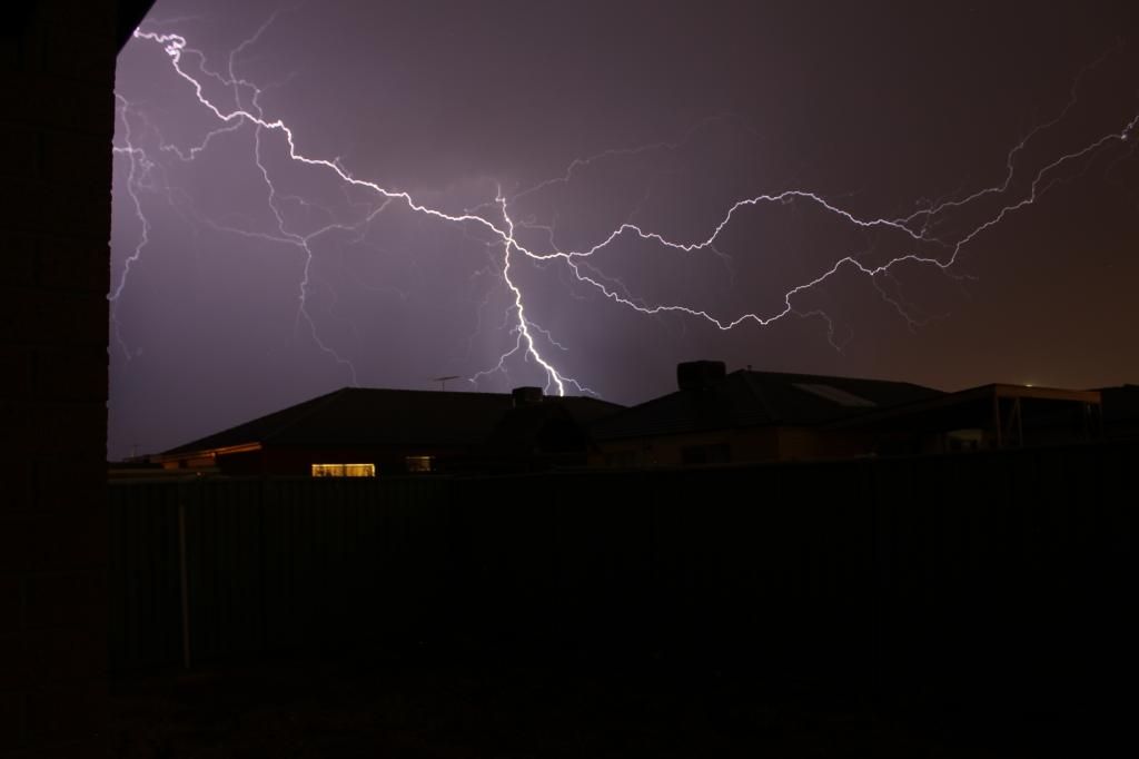
Captured this from my yard as the rain band moved through Wyndham Vale 15 minutes ago. Bring on tomorrow I say!
-
Supercellimpact

- Supercell
- Reactions:
- Posts: 1237
- Joined: Thu Oct 07, 2010 8:39 pm
- Location: Bendigo
Re: Hot and thundery - Tropical moisture feed - Jan 4 to 13
Nice shot weatherviewer !
We have picked up 12mm from a storm about 40mins ago here in Bendigo yet the gauge at airport shows 0.6. Another one about to go overhead, not as strong though. Keen for Tomoz, hopefully some beastly storms
We have picked up 12mm from a storm about 40mins ago here in Bendigo yet the gauge at airport shows 0.6. Another one about to go overhead, not as strong though. Keen for Tomoz, hopefully some beastly storms
-
Australis(Shell3155)

- Supercell
- Reactions:
- Posts: 3146
- Joined: Mon Nov 30, 2009 8:05 pm
- Location: FTG
- Contact:
Re: Hot and thundery - Tropical moisture feed - Jan 4 to 13
Woken by some decent rumbles lights and nice heavy rain,
Darn the outside blinds are down. !
Setting off the outside light.
Darn the outside blinds are down. !
Setting off the outside light.
- wolfcat
- Cumulonumbus Calvas
- Reactions:
- Posts: 562
- Joined: Sun Mar 07, 2010 12:14 pm
- Location: Bentleigh East
- Contact:
Re: Hot and thundery - Tropical moisture feed - Jan 4 to 13
From North Road, Brighton.
To quote Babe "That 'ill do Pig, that 'ill do"
Strike 1
Strike 2
To quote Babe "That 'ill do Pig, that 'ill do"
Strike 1
Strike 2
other places you will find me...
My blog...http://www.wolfcat.com.au/randomrants/
Flickr .. http://www.flickr.com/photos/wolfcat_aus/
Twitter... http://twitter.com/wolfcat
Redbubble... http://www.redbubble.com/people/wolfcat
My blog...http://www.wolfcat.com.au/randomrants/
Flickr .. http://www.flickr.com/photos/wolfcat_aus/
Twitter... http://twitter.com/wolfcat
Redbubble... http://www.redbubble.com/people/wolfcat
- MasterOfRoc
- Cumulus
- Reactions:
- Posts: 58
- Joined: Fri Sep 03, 2010 4:47 pm
- Location: St Arnaud, VIC
Re: Hot and thundery - Tropical moisture feed - Jan 4 to 13
So, We lost the roof from our Hay shed today
A decent enough Sound and light show, and enough rain to settle the dust...
Hopefully a warm up for things to come... Not liking my chances of getting any Cricket in Saturday arvo
A decent enough Sound and light show, and enough rain to settle the dust...
Hopefully a warm up for things to come... Not liking my chances of getting any Cricket in Saturday arvo
-
Onetahuti

- Supercell
- Reactions:
- Posts: 2790
- Joined: Thu Mar 25, 2010 9:37 pm
- Location: Dandenong Nth.
Re: Hot and thundery - Tropical moisture feed - Jan 4 to 13
Slept through the night so do not know about any storm but have 7 mm in the gauge.
The BOM written forecast is at odds with the forecast chart they have put out this morning, Take Sunday, they have a 80% chance of rain in the written forecast but the rainfall forecast chart has no rain.
The BOM written forecast is at odds with the forecast chart they have put out this morning, Take Sunday, they have a 80% chance of rain in the written forecast but the rainfall forecast chart has no rain.
-
mad*moo73

- Cumulonumbus Calvas
- Reactions:
- Posts: 637
- Joined: Mon Mar 08, 2010 2:11 pm
- Location: Keysborough
Re: Hot and thundery - Tropical moisture feed - Jan 4 to 13
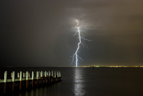
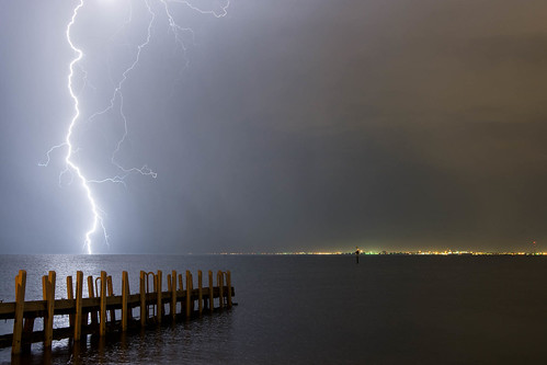
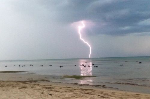
A few pics my daughter took from near Rye beach last evening -
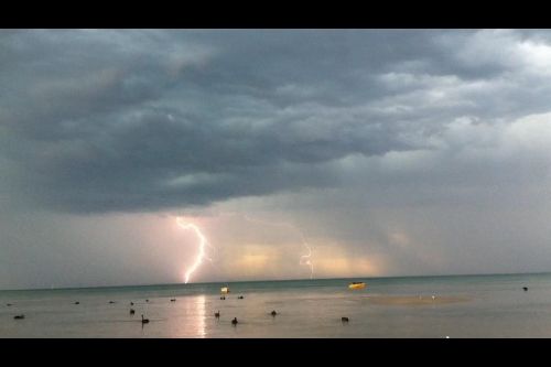
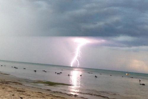
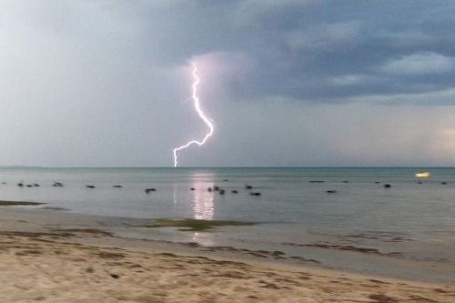


Double Whopper award winning footy tipper!!!!!!!!!!!!!!
-
Rivergirl

- Memorial
- Reactions:
- Posts: 3674
- Joined: Sun Nov 22, 2009 6:04 pm
- Location: Ferny Creek VIC
- Contact:
Re: Hot and thundery - Tropical moisture feed - Jan 4 to 13
Love all the photos. There was also an amazing aurora happening last night but of course you couldn't see it from Victoria with all the cloud cover. I have even seen photos taken from Eden on the NSW coast
- stevco123
- Supercell
- Reactions:
- Posts: 2936
- Joined: Sat Aug 07, 2010 7:42 pm
- Location: Cranbourne 78m asl
Re: Hot and thundery - Tropical moisture feed - Jan 4 to 13
Onetahuti » Thu Jan 08, 2015 5:52 am wrote:Onetahuti wrote:Slept through the night so do not know about any storm but have 7 mm in the gauge.
The BOM written forecast is at odds with the forecast chart they have put out this morning, Take Sunday, they have a 80% chance of rain in the written forecast but the rainfall forecast chart has no rain.
I have no idea how you slept through that with several overhead storms shaking the house.
https://www.weatherlink.com/bulletin/53 ... 76dd68e8bc: for current weather updated every 2 minutes
- BringOnTheCoolChange
- Cumulonimbus
- Reactions:
- Posts: 216
- Joined: Fri Jul 18, 2014 9:27 pm
- Location: East Warburton, Victoria, asl 232m
Re: Hot and thundery - Tropical moisture feed - Jan 4 to 13
Interesting, i never knew you could see an Aurora from NSW, i never have seen any from Victoria lol.Rivergirl » Thu Jan 08, 2015 7:32 am wrote:Rivergirl wrote:Love all the photos. There was also an amazing aurora happening last night but of course you couldn't see it from Victoria with all the cloud cover. I have even seen photos taken from Eden on the NSW coast
And there was a storm overnight? I always sleep through storms.
- I_Love_Storms
- Supercell
- Reactions:
- Posts: 2812
- Joined: Wed Dec 02, 2009 2:01 pm
- Location: Hawthorn
Re: Hot and thundery - Tropical moisture feed - Jan 4 to 13
All models still look good for at least 50mm from here on I think...potentially for higher falls if get under storms and also in country parts of Vic depending on where the low winds up.
-
Rivergirl
- Memorial
- Reactions:
- Posts: 3674
- Joined: Sun Nov 22, 2009 6:04 pm
- Location: Ferny Creek VIC
- Contact:
Re: Hot and thundery - Tropical moisture feed - Jan 4 to 13
Hi BringOnTheCoolChange Yes you can see auroras from Victoria. Here is the one from Eden on the NSW coast taken last night by KJ Janelle

- Gordon
- Supercell
- Reactions:
- Posts: 2888
- Joined: Thu Jun 17, 2010 10:01 am
- Location: Near Gordon, Vic. 620 m asl
Re: Hot and thundery - Tropical moisture feed - Jan 4 to 13
Great photo! The various lightning shots are fantastic too.
- I_Love_Storms
- Supercell
- Reactions:
- Posts: 2812
- Joined: Wed Dec 02, 2009 2:01 pm
- Location: Hawthorn
Re: Hot and thundery - Tropical moisture feed - Jan 4 to 13
Watch back end of rainband near Mt Gambier, will slam us later!
- stevco123
- Supercell
- Reactions:
- Posts: 2936
- Joined: Sat Aug 07, 2010 7:42 pm
- Location: Cranbourne 78m asl
Re: Hot and thundery - Tropical moisture feed - Jan 4 to 13
Nothing so far. THe odd shower passing by giving us 1.2mm so far today (after 9am that is).
Radar looks boring. Trying to develop but no go so far
Radar looks boring. Trying to develop but no go so far
https://www.weatherlink.com/bulletin/53 ... 76dd68e8bc: for current weather updated every 2 minutes
-
Rivergirl
- Memorial
- Reactions:
- Posts: 3674
- Joined: Sun Nov 22, 2009 6:04 pm
- Location: Ferny Creek VIC
- Contact:
Re: Hot and thundery - Tropical moisture feed - Jan 4 to 13
TOP PRIORITY FOR IMMEDIATE BROADCAST
SEVERE THUNDERSTORM WARNING
for DAMAGING WIND, HEAVY RAINFALL and LARGE HAILSTONES
For people in the
East Gippsland,
North East and parts of the
Northern Country and
West and South Gippsland Forecast Districts.
Issued at 1:51 pm Thursday, 8 January 2015.
Severe thunderstorms are likely to produce damaging winds, heavy rainfall that may lead to flash flooding and large hailstones in the warning area over the next several hours. Locations which may be affected include Wodonga, Wangaratta, Sale, Bairnsdale, Orbost and Falls Creek.
The State Emergency Service advises that people should:
* Keep clear of fallen power lines.
* secure any loose objects in the vicinity of your home.
* keep away from creeks and drains.
* do not drive vehicles through flooded areas.
* stay indoors if possible.
* Avoid using the phone during the storm.
* if you are outside, avoid sheltering under trees
* listen to the radio for storm updates
* switch off your computer and electrical appliances
- I_Love_Storms
- Supercell
- Reactions:
- Posts: 2812
- Joined: Wed Dec 02, 2009 2:01 pm
- Location: Hawthorn
Re: Hot and thundery - Tropical moisture feed - Jan 4 to 13
SEVERE THUNDERSTORM WARNING - MELBOURNE AREA
for DAMAGING WIND, HEAVY RAINFALL and LARGE HAILSTONES
For people in the
Geelong and Bellarine Peninsula Local Warning Area.
Issued at 3:08 pm Thursday, 8 January 2015.
The Bureau of Meteorology warns that, at 3:05 pm, severe thunderstorms were detected on weather radar near the area southeast of Colac, the area southwest of Lorne and the area north of Forrest. These thunderstorms are moving towards the east. They are forecast to affect Bass Strait by 3:35 pm and Geelong City, Lara and Torquay by 4:05 pm.
Damaging winds, heavy rainfall that may lead to flash flooding and large hailstones are likely.
The State Emergency Service advises that people should:
* Keep clear of fallen power lines.
* secure any loose objects in the vicinity of your home.
* keep away from creeks and drains.
* do not drive vehicles through flooded areas.
* stay indoors if possible.
* Avoid using the phone during the storm.
* if you are outside, avoid sheltering under trees
* listen to the radio for storm updates
* switch off your computer and electrical appliances
The next warning is due to be issued by 4:10 pm.
A more general severe thunderstorm warning is also current for the East Gippsland, Mallee, Northern Country, North East and parts of the Central, South West, North Central, West and South Gippsland and Wimmera districts.
Warnings are also available through TV and Radio broadcasts, the Bureau's website at http://www.bom.gov.au" onclick="window.open(this.href);return false; or call 1300 659 217. The Bureau and State Emergency Service would appreciate warnings being broadcast regularly.
- Gordon
- Supercell
- Reactions:
- Posts: 2888
- Joined: Thu Jun 17, 2010 10:01 am
- Location: Near Gordon, Vic. 620 m asl
Re: Hot and thundery - Tropical moisture feed - Jan 4 to 13
Severe Weather Warning
for heavy rainfall
for people in the Mallee, Wimmera, Northern Country, North Central, North East, Central, West and South Gippsland and East Gippsland forecast districts
Issued at 3:21 pm EDT on Thursday 8 January 2015.
Weather Situation
A low pressure trough over central Victoria will stall over the northeast of the State tonight, as a cold front moves across Tasmania. The trough will linger near the NSW border on Friday with warm, humid and unstable conditions continuing across the State. A rainband with embedded thunderstorms is likely to extend from the northwest through central areas to Gippsland on Friday. The system is only likely to contract slowly to the northeast during the Friday, producing local heavy falls, particularly about the ranges and in the northwest.
A rainband with embedded thunderstorms and heavy rain may lead to FLASH FLOODING on Friday over inland regions in the west and along the ranges and slopes. The severe weather warning includes the Wimmera, Mallee and Northern Central forecast districts, and parts of the Northern Country, North East, Central, West and South Gippsland and East Gippsland forecast districts.
The State Emergency Service advises that people should:
Don't drive, ride or walk through flood water.
Keep clear of creeks and storm drains.
For emergency help in floods and storms, ring your local SES Unit on 132 500.
The next warning will be issued by 11:00 pm EDT Thursday.
- stevco123
- Supercell
- Reactions:
- Posts: 2936
- Joined: Sat Aug 07, 2010 7:42 pm
- Location: Cranbourne 78m asl
Re: Hot and thundery - Tropical moisture feed - Jan 4 to 13
SO going by the bureau, the heaviest rain will be in a line northeast of mildura, melbourne and wonthaggi. anything to the east of this will see heavy rain whilst west of it will be "less rainy".
At least that's how I interpret it going by their Severe weather warning
At least that's how I interpret it going by their Severe weather warning
https://www.weatherlink.com/bulletin/53 ... 76dd68e8bc: for current weather updated every 2 minutes
- Sean
- Supercell
- Reactions:
- Posts: 1000
- Joined: Mon Feb 27, 2012 6:35 pm
- Location: Patterson Lakes - SE Melb
Re: Hot and thundery - Tropical moisture feed - Jan 4 to 13
Not sure how this is going to play out. Was expecting more by now, but just copping a light sprinkle.
Stayed relatively cool today, which I knew was bound to happen when waking up to that overcast sky. Not sure that's ideal when it comes to storms.
Hoping, anyway.
Stayed relatively cool today, which I knew was bound to happen when waking up to that overcast sky. Not sure that's ideal when it comes to storms.
Hoping, anyway.