
Welcome New Members! We want to hear from you. Register, stop lurking and start posting!
Hot and thundery - Tropical moisture feed - Jan 4 to 14 2015
-
mick

- Supercell
- Reactions:
- Posts: 1453
- Joined: Mon Nov 30, 2009 6:45 pm
- Location: Mid North SA Baaaaaaaaaaaaaaa
Re: Warm/hot and thundery: Jan 4 to 10
Spare a thought for those in SA, the lightning strikes are about to go off the scale.
- Dane
- Supercell
- Reactions:
- Posts: 1661
- Joined: Thu Nov 26, 2009 9:51 am
- Location: Sebastopol 420m ASL
- Contact:
Re: Warm/hot and thundery: Jan 4 to 10
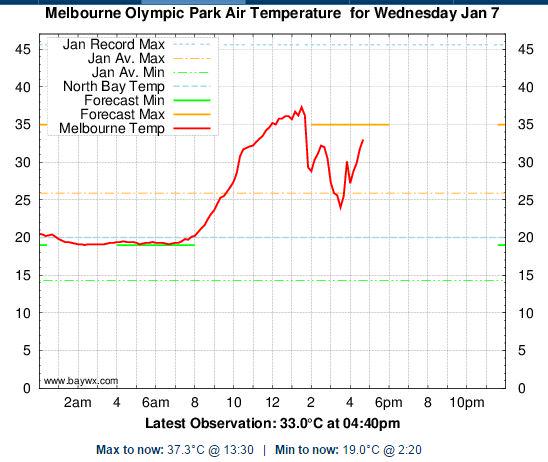
Wow plenty of activity around the City and the inner eastern suburbs, Olympic park has had 18.8mm's (pity they closed the old Latrobe st site yesterday would have made a good comparison). 29mm's has fallen at Gardiners Ck Kinkora rd - not sure exactly where that is and 21mm's ay the Yarra river Burnley.
By comparison I have had no rain or any thunder here in Cranbourne
At least the temp has fallen a bit from 38.2 at 2.51pm to 34.0 now.
Looking at the sky and radar i don't think we will get anything here - not in the next 3 hours anyway.
By comparison I have had no rain or any thunder here in Cranbourne
At least the temp has fallen a bit from 38.2 at 2.51pm to 34.0 now.
Looking at the sky and radar i don't think we will get anything here - not in the next 3 hours anyway.
- Jake Smethurst
- Supercell
- Reactions:
- Posts: 3583
- Joined: Mon Nov 23, 2009 8:49 pm
- Location: Cheltenham
Re: Warm/hot and thundery: Jan 4 to 10
That lightning tracker looks beautiful! Development as expected, though it was strange to see some of the first of it over the city! Driving back from work not long ago, managed to see a couple of CG's, no thunder. I'm in Brighton and generally has missed us, hopefully we can get something later. Development will be possible overnight I'd imagine with nocturnal cooling though it will be more elevated, so the risk of storms stays with us all the way until after the change tomorrow afternoon. There's some pretty strong winds in these too ... 98 km/h gust at St Kilda at 3.11pm. And lots of call outs for damage over Doncaster region.
Tomorrow's action will be way more active. Lots of severe storms likely (and I'm working, indoors with no windows haha).
Tomorrow's action will be way more active. Lots of severe storms likely (and I'm working, indoors with no windows haha).
Jake - Senior AWF Forecaster
Feel free to send me a private message if you have any questions.
Feel free to send me a private message if you have any questions.
- Gordon
- Supercell
- Reactions:
- Posts: 2888
- Joined: Thu Jun 17, 2010 10:01 am
- Location: Near Gordon, Vic. 620 m asl
Re: Warm/hot and thundery: Jan 4 to 10
A long time since I've seen a Ballarat forecast like this one - if ever!
http://www.bom.gov.au/vic/forecasts/ballarat.shtml" onclick="window.open(this.href);return false;
http://www.bom.gov.au/vic/forecasts/ballarat.shtml" onclick="window.open(this.href);return false;
Re: Warm/hot and thundery: Jan 4 to 10
same forecast in Melbourne could be a major storm outbreak makes me think back xmas 2011
- SC.
- Cumulonimbus
- Reactions:
- Posts: 346
- Joined: Wed Nov 25, 2009 5:57 pm
- Location: Wheelers Hill
- Contact:
Re: Warm/hot and thundery: Jan 4 to 10
I've been working on the HMAS Adelaide for the past month, one of best views in Melbourne. I watched that first cloud explode over the bay. It was getting fed rapidly by a large column of steam stretching from the Hotties outside the Newport Power Station to the mouth of the Yarra river. Sadly no cameras allowed on board the ship. 
-
Duckey

- Cumulonimbus
- Reactions:
- Posts: 283
- Joined: Sun Mar 07, 2010 3:39 pm
- Location: Live: Croydon Work: Burwood
Re: Warm/hot and thundery: Jan 4 to 10
Lots of storm damage along station st between Nunawading and Mitcham! Must have been strong winds, just went past on the train and there are trees snapped in half and roofing ripped off the brick place! Winds must have been strong! 
Storm Nerd!!
- wolfcat
- Cumulonumbus Calvas
- Reactions:
- Posts: 562
- Joined: Sun Mar 07, 2010 12:14 pm
- Location: Bentleigh East
- Contact:
Re: Warm/hot and thundery: Jan 4 to 10
Go Home Melbourne Weather, you are drunk...
Last edited by wolfcat on Wed Jan 07, 2015 5:15 pm, edited 1 time in total.
other places you will find me...
My blog...http://www.wolfcat.com.au/randomrants/
Flickr .. http://www.flickr.com/photos/wolfcat_aus/
Twitter... http://twitter.com/wolfcat
Redbubble... http://www.redbubble.com/people/wolfcat
My blog...http://www.wolfcat.com.au/randomrants/
Flickr .. http://www.flickr.com/photos/wolfcat_aus/
Twitter... http://twitter.com/wolfcat
Redbubble... http://www.redbubble.com/people/wolfcat
- Gordon
- Supercell
- Reactions:
- Posts: 2888
- Joined: Thu Jun 17, 2010 10:01 am
- Location: Near Gordon, Vic. 620 m asl
Re: Warm/hot and thundery: Jan 4 to 10
The standout features of the Ballarat forecast are this for Thursday ' A thunderstorm likely, possibly severe with damaging winds, heavy rain and large hail in the afternoon.' ; and ' Heavy falls exceeding 50 mm possible.' for both Saturday & Sunday. Can't recall ever seeing three days of potentially severe weather in one Ballarat 7 day forecastcuz » Wed Jan 07, 2015 3:48 pm wrote:cuz wrote:same forecast in Melbourne could be a major storm outbreak makes me think back xmas 2011
-
mick
- Supercell
- Reactions:
- Posts: 1453
- Joined: Mon Nov 30, 2009 6:45 pm
- Location: Mid North SA Baaaaaaaaaaaaaaa
Re: Warm/hot and thundery: Jan 4 to 10
All calm down the bay, hoping for a sea breeze around dusk, tiopped 40 here, I see plenty of 38s in official stations. anyways, 35 got SMASHED.
Tonight, hard to call, could drop to 22, could hover around 30 till 4am.
WE MUST stop building urban dog boxes that rely on aircon. There is not a house in Pakenham with decent eaves, it was always mildish, the temps have gone up 4 degrees since the housing went in, cheek to jowl, no room for a tree, a set back of a metre to more concrete.
Also time for the state govt to step in and declare nature strips suitable for planting of things not grass. You cant now because it stops people openingcar doors, might be a trip hazard etc if you have a tomato on the nature strip. Anyways, grass in melb on a ns, the n.e etc, just dies and the ground bakes.
Overall tho, a mild summer so far.
-
mad*moo73

- Cumulonumbus Calvas
- Reactions:
- Posts: 637
- Joined: Mon Mar 08, 2010 2:11 pm
- Location: Keysborough
Re: Warm/hot and thundery: Jan 4 to 10
I work in Prahran so got to see the action! Yep that first storm came from nowhere - one minute bright sunshine the next torrential rain. The second storm - wow! Lots of thunder & nearby flangs, the rain well if this is what it's going to be like the next few days we are going to be smashed!
Double Whopper award winning footy tipper!!!!!!!!!!!!!!
- droughtbreaker
- Supercell
- Reactions:
- Posts: 2844
- Joined: Wed Nov 25, 2009 7:50 pm
- Location: Mount Macedon, VIC, 520m asl
Re: Warm/hot and thundery: Jan 4 to 10
Much hotter day than forecast today.
In the last hour or so Cu has broken through the cap and taking off. Small line approaching here on radar, very slow moving with very heavy rain in it judging by radar (dark red core on radar display). Touch and go if it survives intact to here after crossing the mountain but it would be decent to be under IMO.
In the last hour or so Cu has broken through the cap and taking off. Small line approaching here on radar, very slow moving with very heavy rain in it judging by radar (dark red core on radar display). Touch and go if it survives intact to here after crossing the mountain but it would be decent to be under IMO.
- Gordon
- Supercell
- Reactions:
- Posts: 2888
- Joined: Thu Jun 17, 2010 10:01 am
- Location: Near Gordon, Vic. 620 m asl
Re: Warm/hot and thundery: Jan 4 to 10
First rain for the dates (which are going to need extending BTW please mods) has started falling here. A mm or two of gentle thundery rain with more to come. Nice start!
- StratoBendigo
- Supercell
- Reactions:
- Posts: 2809
- Joined: Fri Jan 02, 2015 2:18 pm
- Location: Kangaroo Flat
Re: Warm/hot and thundery: Jan 4 to 10
Which is why we decided to live in an affordable property in Bendigo with a decent backyard, eaves etc instead of a new housing estate/brick desert on the outskirts of Melb.mick wrote: WE MUST stop building urban dog boxes that rely on aircon. There is not a house in Pakenham with decent eaves, it was always mildish, the temps have gone up 4 degrees since the housing went in, cheek to jowl, no room for a tree, a set back of a metre to more concrete.
Also time for the state govt to step in and declare nature strips suitable for planting of things not grass. You cant now because it stops people openingcar doors, might be a trip hazard etc if you have a tomato on the nature strip. Anyways, grass in melb on a ns, the n.e etc, just dies and the ground bakes.
Overall tho, a mild summer so far.
This summer has been quite hot North of the Divide. No rain for weeks. Lawn has turned to dust. Looking forward to seeing some precipitation. IMO we should see over 50mm here. Big letdown if we miss out.
- Jake Smethurst
- Supercell
- Reactions:
- Posts: 3583
- Joined: Mon Nov 23, 2009 8:49 pm
- Location: Cheltenham
Re: Warm/hot and thundery: Jan 4 to 10
Quite a fair bit more development in the last thirty minutes or so. Storms near Geelong and Avalon increasing as well as in the southwest of the state. Also a fairly big complex south of Traralgon, lots of rainfall under that one and flash flooding no doubt.
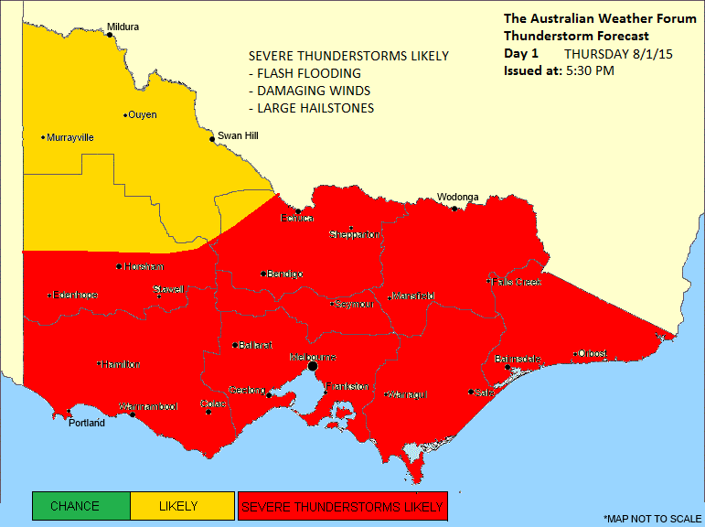
Here's our storm forecast for tomorrow ... and I'll extend the threads date.
Thunderstorm Forecast - Day 1
Issued at 5:30pm Wednesday 7th January 2015
Discussion for Thursday
Very unstable conditions expected Thursday. Moisture levels are expected to be very high across Victoria, with warm to hot surface temperatures and high instability through all areas. This is ahead of a trough of low pressure which will begin moving eastwards across the state during the day, reaching Melbourne at during the middle to latter part of the afternoon. Due to the combination of these variables, scattered thunderstorm activity is likely across all areas of the state, but particularly near the trough of low pressure itself. Flash flooding is again the highest threat regarding severe phenomena, though organized cells are also possible meaning damaging winds and large hail are more likely to occur compared to Wednesday. There is also the small chance of supercell thunderstorms forming, mainly in the south. Isolated thunderstorms are also possible early in the morning due to the quite unstable atmospheric environment.
Jake - Senior AWF Forecaster
Feel free to send me a private message if you have any questions.
Feel free to send me a private message if you have any questions.
-
mick
- Supercell
- Reactions:
- Posts: 1453
- Joined: Mon Nov 30, 2009 6:45 pm
- Location: Mid North SA Baaaaaaaaaaaaaaa
Re: Hot and thundery - Tropical moisture feed - Jan 4 to 13
Theres a mini tornado on the way, wait and see.
- StratoBendigo
- Supercell
- Reactions:
- Posts: 2809
- Joined: Fri Jan 02, 2015 2:18 pm
- Location: Kangaroo Flat
Re: Hot and thundery - Tropical moisture feed - Jan 4 to 13
Lightning strikes are causing problems South of here. Bad grassfire just East of Kyneton.
I'm starting to think that Saturday and Sunday will be the big rain days here with a Northeasterly wind.
I'm starting to think that Saturday and Sunday will be the big rain days here with a Northeasterly wind.
Re: Hot and thundery - Tropical moisture feed - Jan 4 to 13
cells certainly picking up intensity over melb airport can here thunder from it now
- snowshow
- Cumulus
- Reactions:
- Posts: 64
- Joined: Tue Jun 07, 2011 11:42 am
- Location: Boolarra South/Mirboo North
Re: Hot and thundery - Tropical moisture feed - Jan 4 to 13
We just had an incredible storm here at Boolarra, we had torrential rain, largest hail I have ever seen in South Gippsland! Trees down everywhere!! One missed the house by 1/2 and inch 19 mils in the gauge in 10mins I can't believe it! And thats what went in the gauge as the hail was coming in sideways from one direction and then switched and came in the other way!!!
-
mick
- Supercell
- Reactions:
- Posts: 1453
- Joined: Mon Nov 30, 2009 6:45 pm
- Location: Mid North SA Baaaaaaaaaaaaaaa
Re: Hot and thundery - Tropical moisture feed - Jan 4 to 13
Looking at radar, clear anticlockwise direction now over melb, centered un Nerrandera way.
http://realtime2.bsch.au.com/vis_sat2.h ... &stop=#nav" onclick="window.open(this.href);return false;
Also, cells popping up more to the west than earlier on but more of them.
http://realtime2.bsch.au.com/vis_sat2.h ... &stop=#nav" onclick="window.open(this.href);return false;
Also, cells popping up more to the west than earlier on but more of them.