
Welcome New Members! We want to hear from you. Register, stop lurking and start posting!
Victoria: Sequence of spring fronts: 7-15 September
- I_Love_Storms
- Supercell
- Reactions:
- Posts: 2812
- Joined: Wed Dec 02, 2009 2:01 pm
- Location: Hawthorn
Re: Sequence of spring fronts: 7-15 September
Tuesday afternoon is looking interesting for potential storms. Something to keep an eye on.
-
Australis(Shell3155)

- Supercell
- Reactions:
- Posts: 3146
- Joined: Mon Nov 30, 2009 8:05 pm
- Location: FTG
- Contact:
Re: Sequence of spring fronts: 7-15 September
Whens the rain.. ?
I need to MOW....
I need to MOW....
- Jake Smethurst
- Supercell
- Reactions:
- Posts: 3583
- Joined: Mon Nov 23, 2009 8:49 pm
- Location: Cheltenham
Re: Sequence of spring fronts: 7-15 September
Website and forum back up and running! 
Will comment further on tomorrow's activity, but storm likelihood is good!
Will comment further on tomorrow's activity, but storm likelihood is good!
Jake - Senior AWF Forecaster
Feel free to send me a private message if you have any questions.
Feel free to send me a private message if you have any questions.
- Jake Smethurst
- Supercell
- Reactions:
- Posts: 3583
- Joined: Mon Nov 23, 2009 8:49 pm
- Location: Cheltenham
Re: Sequence of spring fronts: 7-15 September
Sure looks like the winds tonight will strengthen a little ahead of the front and trough due tomorrow. Speaking of tomorrow, and I don't think things look too bad. Areas of patchy rain will extend from the west and become more extensive over the northeast later in the day. Timing of the trough looks relatively good for central areas in-terms of thunderstorm development. Models certainly showing quite unstable conditions around that time with strong convergence and shear! Wouldn't be surprised to see some thunderstorms go up over central and eastern parts during the afternoon ... and also in the southwest at night with colder air. Rainfall wise looking like general 10-30mm, less in the west and northwest, much more in the northeast where heavier falls likely to develop at night.
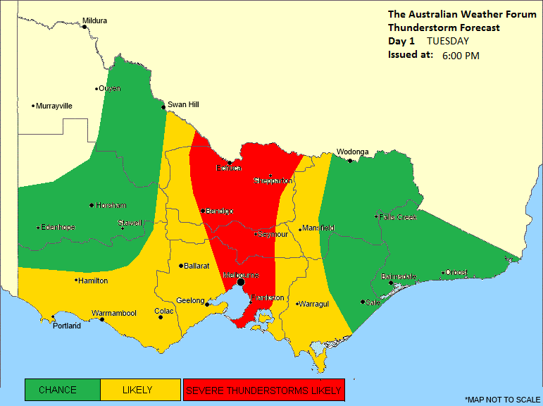
Here is our thunderstorm forecast for tomorrow, and can be found here: http://theaustralianweatherforum.com/vi ... ecast.html
Victoria Thunderstorm Forecast
Thunderstorm Forecast - Day 1
Issued at 6:00pm Monday 8th September 2014
Discussion for Tuesday:
A front and trough will cross Victoria during Tuesday. The system is expected over the southwest during the morning, central parts during the mid to late afternoon and eastern districts at night. At this stage there does appear to be a significant risk for thunderstorm development, particularly over parts of central and eastern districts due to timing of the trough. There is also strong convergence and high wind shear, which means a risk of severe thunderstorms also through central parts of the state, where damaging winds and large hailstones are possible. A second risk area will be in the southwest and coastal parts at night, with cold-air thunderstorms possible (15% risk). The far northwest should remain reasonably stable.
Jake - Senior AWF Forecaster
Feel free to send me a private message if you have any questions.
Feel free to send me a private message if you have any questions.
-
Didjman

- Supercell
- Reactions:
- Posts: 2099
- Joined: Fri Sep 03, 2010 2:52 pm
- Location: Wallan, Vic 328m ASL
- Contact:
Re: Sequence of spring fronts: 7-15 September
Wind here to 48klm/hr and building. Ten minute ave 23. Baro plummetting thru 1007.9. Going to Frankston tomorrow(have camera and trigger packed).
Peter
Peter
- aussiestormfreak
- Cumulonumbus Calvas
- Reactions:
- Posts: 534
- Joined: Thu Feb 03, 2011 9:52 am
- Location: Melbourne, Corryong, Merimbula, and Fiji
- Contact:
Re: Sequence of spring fronts: 7-15 September
Hey guys!! 
Sorry for my prolonged absence, I haven't had much to post in recent months, but I do come here often to get more weather information but that chart that Jake put up REALLY grabbed my attention and I couldn't resist! I'm placing my bets on that chart for severe thunderstorms here in Melbourne tomorrow afternoon!
Very gusty weather at my end near the Dandenongs, and mild too with the temperature at around 18C and winds reaching up to around 35km/h.
- I_Love_Storms
- Supercell
- Reactions:
- Posts: 2812
- Joined: Wed Dec 02, 2009 2:01 pm
- Location: Hawthorn
Re: Sequence of spring fronts: 7-15 September
Looks on to me. EC has 20mm for Rowville tomorrow. Expect at least one storm tomorrow afternoon with heavy rain at the very least. Maybe a few lines will come through as the trough approaches with gusty winds. Should make for some good photos!
- Wilko
- Supercell
- Reactions:
- Posts: 1492
- Joined: Wed Aug 11, 2010 12:08 pm
- Location: Moorabbin & Highett, Vic
Re: Sequence of spring fronts: 7-15 September
Wind getting very squally. Nothing then really strong gust
Last one just clocked at 78km
Last one just clocked at 78km
-
93ben
- Site Admin
- Reactions:
- Posts: 603
- Joined: Tue Dec 27, 2011 12:28 am
- Location: Templestowe, Victoria
- Contact:

Re: Sequence of spring fronts: 7-15 September
Really windy in Templestowe atm. Haven't been on this site for a long time but when there's severe weather like this I get excited. Hopefully it's not too bad tomorrow since I work outdoors in the gardens at the freeway golf course.
- I_Love_Storms
- Supercell
- Reactions:
- Posts: 2812
- Joined: Wed Dec 02, 2009 2:01 pm
- Location: Hawthorn
Re: Sequence of spring fronts: 7-15 September
The temperature just jumped to 21c in the city!!
- Wilko
- Supercell
- Reactions:
- Posts: 1492
- Joined: Wed Aug 11, 2010 12:08 pm
- Location: Moorabbin & Highett, Vic
Re: Sequence of spring fronts: 7-15 September
Wind is going nuts in last Hour
At this rate there's going be some damage
TEMP on rise as well
At this rate there's going be some damage
TEMP on rise as well
- SC.
- Cumulonimbus
- Reactions:
- Posts: 346
- Joined: Wed Nov 25, 2009 5:57 pm
- Location: Wheelers Hill
- Contact:
Re: Sequence of spring fronts: 7-15 September
Blowing a gale here. Got wind speeds up to 49km/h WS doesn't give me wind gusts. 
- I_Love_Storms
- Supercell
- Reactions:
- Posts: 2812
- Joined: Wed Dec 02, 2009 2:01 pm
- Location: Hawthorn
Re: Sequence of spring fronts: 7-15 September
EC has halved the rain for Rowville this afternoon but still has about 10mm. Will just be a bit of luck with timing I think.
- Skywalker
- Supercell
- Reactions:
- Posts: 1871
- Joined: Sun Nov 29, 2009 10:03 am
- Location: Burnside Heights/Cowes (Home) & Sunshine West (Work)
Re: Sequence of spring fronts: 7-15 September
Think I qualified for next years tour de france with the ride into work this morning. That wind was right behind me for most of the trip in. I must of been doing at least 80 km/h. 

Unfortunately no rain yet, need it after the damage this wind is causing to the plants.
Unfortunately no rain yet, need it after the damage this wind is causing to the plants.
Caroline Springs, Melbourne's meteorological boredom zone.
- Dane
- Supercell
- Reactions:
- Posts: 1661
- Joined: Thu Nov 26, 2009 9:51 am
- Location: Sebastopol 420m ASL
- Contact:
Re: Sequence of spring fronts: 7-15 September
Very Mild and windy last night, unfortunately very little rain so far, just 1mm here.
Hopefully we got some good showers maybe a storm this afternoon.
Hopefully we got some good showers maybe a storm this afternoon.
Re: Sequence of spring fronts: 7-15 September
Wind starting to increase again here in West Gippy....gusting to 42.6kmh and temp sitting on a mild 17.2.....only 1.0mm rain thus far which is similar to the SE suburbs.
- I_Love_Storms
- Supercell
- Reactions:
- Posts: 2812
- Joined: Wed Dec 02, 2009 2:01 pm
- Location: Hawthorn
Re: Sequence of spring fronts: 7-15 September
Very deep low pressure centre south of Tassie at 963 linking into our trough! Think the radar will go a bit crazy this arvo
- aussiestormfreak
- Cumulonumbus Calvas
- Reactions:
- Posts: 534
- Joined: Thu Feb 03, 2011 9:52 am
- Location: Melbourne, Corryong, Merimbula, and Fiji
- Contact:
Re: Sequence of spring fronts: 7-15 September
Definitely a potential for storm development here in Melbourne! I can sense it! I hope I'm right!!
Crazy night with wind gusts to 48km/h, 1.1mm of rain, and a low of 14.2°C. It stayed around 18°C for most of the night. Currently 16°C.
Hope the trough can work its magic in the next 6 hours or so!!
Crazy night with wind gusts to 48km/h, 1.1mm of rain, and a low of 14.2°C. It stayed around 18°C for most of the night. Currently 16°C.
Hope the trough can work its magic in the next 6 hours or so!!
- I_Love_Storms
- Supercell
- Reactions:
- Posts: 2812
- Joined: Wed Dec 02, 2009 2:01 pm
- Location: Hawthorn
Re: Sequence of spring fronts: 7-15 September
Going off in the bay nowaussiestormfreak » Tue Sep 09, 2014 10:46 am wrote:aussiestormfreak wrote:Definitely a potential for storm development here in Melbourne! I can sense it! I hope I'm right!!
Crazy night with wind gusts to 48km/h, 1.1mm of rain, and a low of 14.2°C. It stayed around 18°C for most of the night. Currently 16°C.
Hope the trough can work its magic in the next 6 hours or so!!
Re: Sequence of spring fronts: 7-15 September
hillybilly » Tue Sep 09, 2014 7:16 am wrote:hillybilly wrote:Outdoor furniture was blown around the back garden last night and heard one crash-boom so something fell in the garden
Really feels like an El Niño front out there currently, with dry and mild air and gales. 0.6mm so far.
Today's looks promising, but point where development fires will be near Melbourne so hopefully to our west and not east. LI to drop into negative values mid arvo so some reasonable instability. Little front back in the bight will be the focus.
Do we need an El Nino for this?
Anyway hoping to get 5mm here but we shall see how it pans out.