
Welcome New Members! We want to hear from you. Register, stop lurking and start posting!
Extended Hot Spell Vic Jan 27th 2014 onward
-
dagget

- Cumulonimbus
- Reactions:
- Posts: 480
- Joined: Sun Nov 29, 2009 10:35 pm
- Location: Trentham (705m ASL)
Re: Extended Hot Spell Vic Jan 27th 2014 onward
Horribly windy up here yesterday and today, trees down, power out, trains disrupted, dont know which I like less this or the heat
-
stratospear

- Supercell
- Reactions:
- Posts: 1261
- Joined: Sat Dec 19, 2009 9:38 am
- Location: Usually Bendigo
Re: Extended Hot Spell Vic Jan 27th 2014 onward
Today's wind set off some aggressive grass fires - the one at Malmsbury was fortunately stopped in good time.
Sunday looks like it could be a bit nasty.
Sunday looks like it could be a bit nasty.
- wolfcat
- Cumulonumbus Calvas
- Reactions:
- Posts: 562
- Joined: Sun Mar 07, 2010 12:14 pm
- Location: Bentleigh East
- Contact:
Re: Extended Hot Spell Vic Jan 27th 2014 onward
A touch on the windy side out there at the moment ( Yes that is a technical term I think BoM should use )
other places you will find me...
My blog...http://www.wolfcat.com.au/randomrants/
Flickr .. http://www.flickr.com/photos/wolfcat_aus/
Twitter... http://twitter.com/wolfcat
Redbubble... http://www.redbubble.com/people/wolfcat
My blog...http://www.wolfcat.com.au/randomrants/
Flickr .. http://www.flickr.com/photos/wolfcat_aus/
Twitter... http://twitter.com/wolfcat
Redbubble... http://www.redbubble.com/people/wolfcat
- Geoff
- Supercell
- Reactions:
- Posts: 2538
- Joined: Tue Jul 05, 2011 9:46 pm
- Location: Olinda VIC (470m ASL)
Re: Extended Hot Spell Vic Jan 27th 2014 onward
Desperate, desperate, desperate, another 10 days of the same old pattern, including a dangerous windy change on Sunday. However... EC and GFS both showing a possible rain event around the 14th-15th Feb, could it be the St.Valentines Day deluge??? A lot of gardens will be dead by then, but we'll take anything we can get now.
AWF Rainfall Details - Monthly rainfall stats. Please post your totals here at the end of each month, thank you –
http://www.theaustralianweatherforum.co ... &start=180
http://www.theaustralianweatherforum.co ... &start=180
- I_Love_Storms
- Supercell
- Reactions:
- Posts: 2812
- Joined: Wed Dec 02, 2009 2:01 pm
- Location: Hawthorn
Re: Extended Hot Spell Vic Jan 27th 2014 onward
It looks pretty much the same for at least the next week or so - dry and hot. Awaiting 18z GFS. Latest EC has slowed the change down Sunday so that is a good sign. Hopefully some moisture can find its way down soon!!!!
- norwester
- Cumulonimbus
- Reactions:
- Posts: 105
- Joined: Sat Feb 05, 2011 9:54 am
- Location: Merbein, Vic
Re: Extended Hot Spell Vic Jan 27th 2014 onward
Yesterdays "chilly" 33C was lovely - got the lawns mowed (I mean the dead brown stuff), thousands of dead leaves raked, outside of house ready for open inspection on Saturday. Lots of trees with burnt bits, everything looking rather unappealing really. Now back to the heat!
Dry, dusty and hot - usually!
- wolfcat
- Cumulonumbus Calvas
- Reactions:
- Posts: 562
- Joined: Sun Mar 07, 2010 12:14 pm
- Location: Bentleigh East
- Contact:
Re: Extended Hot Spell Vic Jan 27th 2014 onward
Extreme Fire Danger now predicted for Sat and Sun for Central Region.
Hope there are not even any small fires in the hills on this Sunday Feb 9, the trauma for surviours of Black Saturday would be unimaginable.
Hope there are not even any small fires in the hills on this Sunday Feb 9, the trauma for surviours of Black Saturday would be unimaginable.
other places you will find me...
My blog...http://www.wolfcat.com.au/randomrants/
Flickr .. http://www.flickr.com/photos/wolfcat_aus/
Twitter... http://twitter.com/wolfcat
Redbubble... http://www.redbubble.com/people/wolfcat
My blog...http://www.wolfcat.com.au/randomrants/
Flickr .. http://www.flickr.com/photos/wolfcat_aus/
Twitter... http://twitter.com/wolfcat
Redbubble... http://www.redbubble.com/people/wolfcat
- Nick Sykes
- Cumulonimbus
- Reactions:
- Posts: 353
- Joined: Wed Nov 25, 2009 6:16 pm
- Location: Gungahlin, ACT
Re: Extended Hot Spell Vic Jan 27th 2014 onward
Yeah this coming weekend looks pretty bad for fire conditions, the only bright spot is that some models have the change on Sunday through Melbourne late morning/lunchtime, which will mean the worst possible conditions should miss the Melbourne area (note - some models have the change later).
Leading up to the change winds look like reaching severe levels overnight sat, sunday morning, 850 winds are predicted around 50-60knots with 850 temps around 24-25C, will result in a well mixed atmosphere and allow winds to gust to around 90km/h. This will result in a near record minimum, 30C minimum predicted for Saturday night for Melbourne, would have to be the highest min temp I've seen forecast.
Nick
- Wilko
- Supercell
- Reactions:
- Posts: 1492
- Joined: Wed Aug 11, 2010 12:08 pm
- Location: Moorabbin & Highett, Vic
Re: Extended Hot Spell Vic Jan 27th 2014 onward
That's it
I'm sleeping in the bath Sat night
Currently doing the pros and cons of getting Evaporative cooling
vs Split system A/C for next summer !!!
I'm sleeping in the bath Sat night
Currently doing the pros and cons of getting Evaporative cooling
vs Split system A/C for next summer !!!
- wolfcat
- Cumulonumbus Calvas
- Reactions:
- Posts: 562
- Joined: Sun Mar 07, 2010 12:14 pm
- Location: Bentleigh East
- Contact:
Re: Extended Hot Spell Vic Jan 27th 2014 onward
so from what I can tell the record overnight low for Melbourne is 30.6 degrees recorded on February 1, 1902 and Jan 12, 2010.
The updated forecast is still 30c for Saturday night... could be a close thing.
The updated forecast is still 30c for Saturday night... could be a close thing.
other places you will find me...
My blog...http://www.wolfcat.com.au/randomrants/
Flickr .. http://www.flickr.com/photos/wolfcat_aus/
Twitter... http://twitter.com/wolfcat
Redbubble... http://www.redbubble.com/people/wolfcat
My blog...http://www.wolfcat.com.au/randomrants/
Flickr .. http://www.flickr.com/photos/wolfcat_aus/
Twitter... http://twitter.com/wolfcat
Redbubble... http://www.redbubble.com/people/wolfcat
- Geoff
- Supercell
- Reactions:
- Posts: 2538
- Joined: Tue Jul 05, 2011 9:46 pm
- Location: Olinda VIC (470m ASL)
Re: Extended Hot Spell Vic Jan 27th 2014 onward
Yes, it's been there for a few runs now so starting to get just a little bit excited, but as you rightly say it is a long way off and things could change.hillybilly wrote: Progs still showing a break in the dry pattern late next week. Long way off - so low confidence - but all models agree that the current rainless pattern may ease.
It's looking like the change on Sunday will reach central districts early rather than late in the day (for once), so we may well dodge another bullet then, here's hoping, a late change could've been very worrying.
AWF Rainfall Details - Monthly rainfall stats. Please post your totals here at the end of each month, thank you –
http://www.theaustralianweatherforum.co ... &start=180
http://www.theaustralianweatherforum.co ... &start=180
- norwester
- Cumulonimbus
- Reactions:
- Posts: 105
- Joined: Sat Feb 05, 2011 9:54 am
- Location: Merbein, Vic
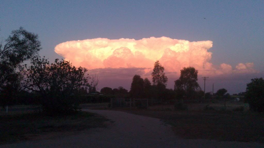
Re: Extended Hot Spell Vic Jan 27th 2014 onward
This was dominating an otherwise clear blue sky just on sunset as I walked the dogs. Apologies for awful quality I had to use my phone.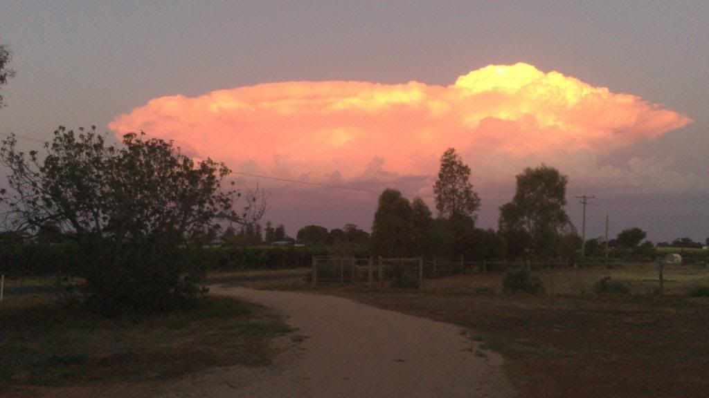


Dry, dusty and hot - usually!
- Geoff
- Supercell
- Reactions:
- Posts: 2538
- Joined: Tue Jul 05, 2011 9:46 pm
- Location: Olinda VIC (470m ASL)
Re: Extended Hot Spell Vic Jan 27th 2014 onward
Oooooh norwester, that is the most beautiful, wonderful thing I've seen this year, thanks for sharing! 
(p.s. send some down here please).
(p.s. send some down here please).
AWF Rainfall Details - Monthly rainfall stats. Please post your totals here at the end of each month, thank you –
http://www.theaustralianweatherforum.co ... &start=180
http://www.theaustralianweatherforum.co ... &start=180
- droughtbreaker
- Supercell
- Reactions:
- Posts: 2844
- Joined: Wed Nov 25, 2009 7:50 pm
- Location: Mount Macedon, VIC, 520m asl
Re: Extended Hot Spell Vic Jan 27th 2014 onward
Is it just me, or are models starting to fizz Sunday's system out a bit with each run. I notice BOM has knocked off about 5km/hr off the wind forecasts and the latest GFS is showing the low sliding south over Tas a bit more with a much vaguer, later and weaker change than in previous runs, and generally light winds inland right through the weekend. A fair bit of wind near the coast though but nothing significant.
Of course I am commenting on just one run, and it's the less reliable 06z run.
Chances firming for a thundery change on Friday with the potential for some half decent rain on and south of the ranges. We need this to continue to firm as 5-10mm of rain, if it miraculously came off, would be handy coming into the severe weekend weather.
- norwester
- Cumulonimbus
- Reactions:
- Posts: 105
- Joined: Sat Feb 05, 2011 9:54 am
- Location: Merbein, Vic
Re: Extended Hot Spell Vic Jan 27th 2014 onward
Sorry, it seems to have remained absolutely stationary about 50km west of us Geoff - radar has it dropping some rain so hopefully no fires being sparked by lightening.
Dry, dusty and hot - usually!
- Jake Smethurst
- Supercell
- Reactions:
- Posts: 3583
- Joined: Mon Nov 23, 2009 8:49 pm
- Location: Cheltenham
Re: Extended Hot Spell Vic Jan 27th 2014 onward
Latest guidance does seem to have pushed the low further south on Sunday Andrew compared to previous days, and the change appears to be weaker due to that. As a result we could say that the southwesterly may be delayed by a few more hours and come through during the early afternoon for central areas (Melbourne about 1pm/2pm compared to previously 11am/12pm). GFS is also now suggesting that it will struggle to push inland during the afternoon and won't really push through until night time for eastern and northern parts. The winds as well don't look to be as strong but something to keep an eye on. Will be a critical fire weather day nonetheless and future model runs will determine change timing more accurately.
As for today looking hot throughout, although parts of the coast may escape the worst with a seabreeze this afternoon. A trough extending down from the northwest coupled with slightly elevated moisture levels and high temperatures may mean that isolated thundery showers are a risk across much of western and central Victoria this afternoon, and then similarly over central and eastern areas Friday afternoon as the trough moves through.
Otherwise, enjoy the heat and more of it with models increasing temperatures next week a little but the majority still indicate a potential break in the 'rainless' pattern later next week. Something to watch.
Jake - Senior AWF Forecaster
Feel free to send me a private message if you have any questions.
Feel free to send me a private message if you have any questions.
- Nick Sykes
- Cumulonimbus
- Reactions:
- Posts: 353
- Joined: Wed Nov 25, 2009 6:16 pm
- Location: Gungahlin, ACT
Re: Extended Hot Spell Vic Jan 27th 2014 onward
OK bit of a broken record but looks like 2 more heatwaves for Vic in the near term, today will get 35 plus in most of Vic, similar Fri, then a scorcher Sat with 40-42 in Melbourne, which will be the 6th 40 of the summer.
Cool change sun after oppressive near record overnight min of 30, brief cool change Mon, back over 30 Tues, then another heatwave starts, temps rising to mid high 30's from Weds with 40 possible again. Thank God in Tassie next week.
P.S another heatwave on horizon for following week, interesting to see what the av max this Feb will be, on track for 30 plus.
- Wilko
- Supercell
- Reactions:
- Posts: 1492
- Joined: Wed Aug 11, 2010 12:08 pm
- Location: Moorabbin & Highett, Vic
Re: Extended Hot Spell Vic Jan 27th 2014 onward
Watching the monsoon trough lots of Lows spinning up along the trough line up north
Some of the models indicated some rain late next week but that seems to be dissipating
Originally indicated some moisture feeding down all the way thru SA into Victoria
now most of that moisture is progged going South thru WA and will only bring more heatwave conditions argh !
Could be a repeated dry heatwaves especially if the northwesterlies kick in
Today and tomorrow are manageable with the southerlies near the bay
- I_Love_Storms
- Supercell
- Reactions:
- Posts: 2812
- Joined: Wed Dec 02, 2009 2:01 pm
- Location: Hawthorn
Re: Extended Hot Spell Vic Jan 27th 2014 onward
Latest GFS just looks hot and dry. Saturday probably 41-42. Sunday probably an early spike up to mid to high 30s with windy conditions. Then mid next week the hot stuff comes back, with potentially a couple more days around 40, depending on southerlies...
- droughtbreaker
- Supercell
- Reactions:
- Posts: 2844
- Joined: Wed Nov 25, 2009 7:50 pm
- Location: Mount Macedon, VIC, 520m asl
Re: Extended Hot Spell Vic Jan 27th 2014 onward
This is basically 1980/1981 all over again, but with a background of at least 1 degree global warming since then.
Back in March 2008 during that perverse heatwave that went on for about a decade, a few of us were pondering what could possibly happen if the same setup occurred during the hottest part of summer rather than early Autumn as it did then. Well the last month gives some sort of idea.
This sort of summer taken in isolation doesn't concern me all that much. The fact that we have had back to back summers with similar conditions (this year is even worse for us), and so many analogous events from just the past 5 years, really does concern me.