
Welcome New Members! We want to hear from you. Register, stop lurking and start posting!
Search found 182 matches
- Wed Jan 30, 2019 4:28 pm
- Forum: Australian Weather Archives
- Topic: VIC - Hot and humid with showers and storms: Last week of January 2019
- Replies: 145
- Views: 59917
Re: VIC - Hot and humid with showers and storms: Last week of January 2019
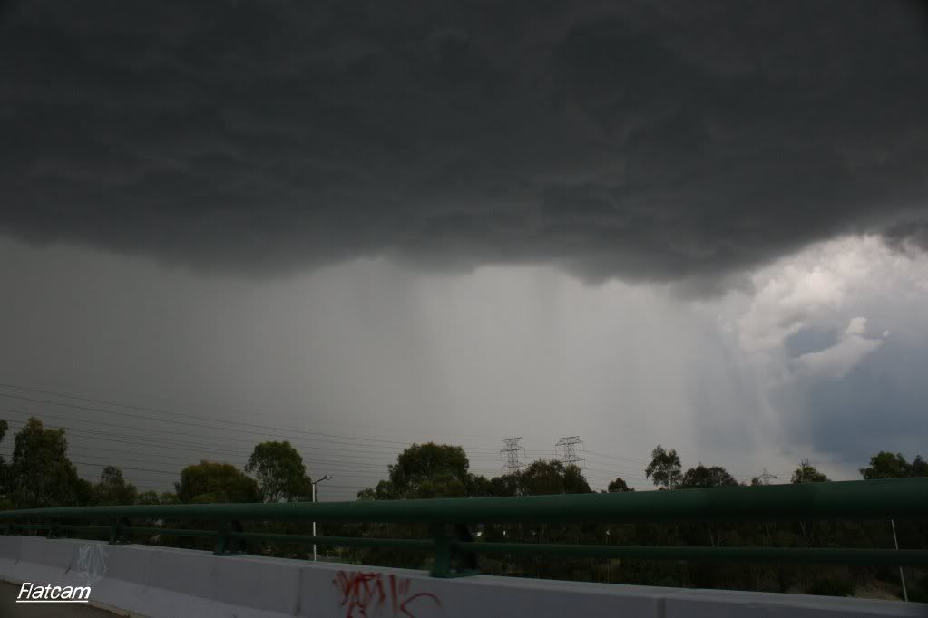
The cell near Wallan has some amazing structure and looks very nasty. There were some lowerings along the rain-free base on the southern edge, and it has a very turbulent-looking base.
- Sat Dec 15, 2018 3:02 pm
- Forum: Australian Weather Archives
- Topic: Victoria: Major upper and surface lows - 12–16 Dec 2018
- Replies: 444
- Views: 167477
Re: Major upper and surface lows 12–16 Dec
Great photos SC. 
Round 2 may be forming to the NE. Hopefully the cells continue to grow and merge. Had some great thunder earlier, but the main cell moved southeastwards into the eastern suburbs, and we just got the messy stuff around it.
Round 2 may be forming to the NE. Hopefully the cells continue to grow and merge. Had some great thunder earlier, but the main cell moved southeastwards into the eastern suburbs, and we just got the messy stuff around it.
- Tue Nov 20, 2018 4:09 pm
- Forum: Australian Weather Archives
- Topic: Victoria: Low & Cold Front - 20-24 November 2018
- Replies: 268
- Views: 92944
Re: Low & Cold Front 20-24 November
Super strong winds ahead of the storm east of Melbourne Airport! The wind was blowing lots of tree debris across the Craigieburn Bypass.
- Mon Jan 29, 2018 5:14 pm
- Forum: Australian Weather Archives
- Topic: VIC: Hot and humid with some storms - January 24 to 31 2018
- Replies: 510
- Views: 215527
Re: Hot, humid with some storms: January 24-31
Managed to get a glimpse of some of the storms near Gisbourne and Melton before the low misty cloud blew in from the south. Definitely a lot of rain in them, and some nice healthy inflow bands were present. Plenty of scud was being generated in front of the storms too and being sucked in. Definitely...
- Sun Jan 28, 2018 12:06 pm
- Forum: Australian Weather Archives
- Topic: VIC: Hot and humid with some storms - January 24 to 31 2018
- Replies: 510
- Views: 215527
Re: Hot, humid with some storms: January 24-31
Radar shows a big blob of rain moving in but all i see is clear skies. I would be asking questions to the developers of this radar if this is interference in the system. I was wondering if the radar was picking up moisture developing as temperatures dropped closer to the dew point in some areas? I ...
- Fri Jan 26, 2018 6:47 pm
- Forum: Australian Weather Archives
- Topic: VIC: Hot and humid with some storms - January 24 to 31 2018
- Replies: 510
- Views: 215527
Re: Hot, humid with some storms: January 24-31
The cell north of Kilmore has been going crazy with lightning over the last 30 mins 
We are getting occasional rolling thunder here in Craigieburn. Hope it sustains until after sunset so we can witness another great lightning show.
We are getting occasional rolling thunder here in Craigieburn. Hope it sustains until after sunset so we can witness another great lightning show.
- Thu Jan 25, 2018 11:07 pm
- Forum: Australian Weather Archives
- Topic: VIC: Hot and humid with some storms - January 24 to 31 2018
- Replies: 510
- Views: 215527
Re: Hot, humid with some storms: January 24-31
Incredible lightning show over the last hour or so looking south from Craigieburn. Some beautiful forked lightning moving across the sky, with some of the closer ones being almost blinding at times. The action has slowed here now, but hope people to the south get to watch this awesome display from a...
- Sat Dec 30, 2017 11:29 am
- Forum: Australian Weather Archives
- Topic: VIC - Becoming hot with showers and storms: December 27-30 2017
- Replies: 89
- Views: 45100
Re: VIC - Becoming hot with showers and storms: December 27-30 2017
60mm here in about 18 minutes. I have never ever experienced anything like it in my life. Roofs collapsed, shops and houses that have never had water in them were flooded (we were at work). Roads closed galore and an idiot that went through the road closed barrier and hit a car at a roundabout. The...
- Fri Dec 29, 2017 2:34 am
- Forum: Australian Weather Archives
- Topic: VIC - Becoming hot with showers and storms: December 27-30 2017
- Replies: 89
- Views: 45100
Re: VIC - Becoming hot with showers and storms: December 27-30 2017
Thanks Snowfall. Shell, yes we are here (Mansfield, Lake Eildon) and were on the boat when this surprise package revealed itself. 22mm in about 30mins. Totally caught in the middle of it as were several others. Power out for 3 hours. Jasmine, what does the v notch represent? Here's a few seconds of...
- Wed Dec 20, 2017 2:36 pm
- Forum: Australian Weather Archives
- Topic: Victoria - Becoming hot with a thunder change: Dec 16-19
- Replies: 160
- Views: 78794
Re: Becoming hot with a thunder change: Dec 16-19
Here is a picture of the cell with a green core from earlier yesterday afternoon which intensified around Donnybrook and headed SE towards Lilydale. Unfortunately, I was in an absolutely terrible position to view the storm, as you can see from the picture haha. http://i1123.photobucket.com/albums/l5...
- Wed Dec 20, 2017 11:48 am
- Forum: Australian Weather Archives
- Topic: Victoria - Becoming hot with a thunder change: Dec 16-19
- Replies: 160
- Views: 78794
Re: Becoming hot with a thunder change: Dec 16-19
Goes to show how storm deprived some people have become going by the posts from yesterday's events. ;) From the reports I've read both through the media & on here nothing that occurred yesterday even comes close to the magical events of early 2010 when we were smashed by two severe storms insid...
- Tue Dec 19, 2017 9:43 pm
- Forum: Australian Weather Archives
- Topic: Victoria - Becoming hot with a thunder change: Dec 16-19
- Replies: 160
- Views: 78794
Re: Becoming hot with a thunder change: Dec 16-19
Extensive mammatus on the underside of the anvil after the storm moved through. Looks beautiful :) Whiteout in Elwood. Would love to see a pic flatcam. No worries. Here's a picture from Mount Ridley looking south towards the CBD: http://i1123.photobucket.com/albums/l551/flatcam/Mammatus%20-%201.jpg
- Tue Dec 19, 2017 8:00 pm
- Forum: Australian Weather Archives
- Topic: Victoria - Becoming hot with a thunder change: Dec 16-19
- Replies: 160
- Views: 78794
Re: Becoming hot with a thunder change: Dec 16-19
Extensive mammatus on the underside of the anvil after the storm moved through. Looks beautiful 
- Tue Dec 19, 2017 7:52 pm
- Forum: Australian Weather Archives
- Topic: Victoria - Becoming hot with a thunder change: Dec 16-19
- Replies: 160
- Views: 78794
Re: Becoming hot with a thunder change: Dec 16-19
That thunderstorm heading towards the CBD was just insane. Day turned to night almost here in Craigieburn, and the sky had a distinctive green tinge. Constant lightning every few seconds! Just insane.
- Tue Mar 21, 2017 9:49 am
- Forum: Australian Weather Archives
- Topic: Victoria: Tropical rain event - March 19 to 23 2017
- Replies: 297
- Views: 120016
Re: Victoria: Tropical rain event - March 19 to 23 2017
Here's some rushed iPhone photos through the car window of the storm just north of Sunbury yesterday as my Dad was driving. The storm dissipated by the time we stopped and were able to get an SLR out :( http://i1123.photobucket.com/albums/l551/flatcam/IMG_4690.jpg http://i1123.photobucket.com/albums...
- Thu Dec 29, 2016 3:56 pm
- Forum: Australian Weather Archives
- Topic: Vic: Long warm/hot spell, unsettled end - December 24-31 2016
- Replies: 531
- Views: 197753
Re: Vic: Long warm/hot spell, unsettled end - December 24-
That storm heading towards Melbourne (just east of Melbourne) dumped some of the heaviest rain I've seen! Drains easily overflowing.
- Sun Feb 26, 2012 8:44 pm
- Forum: Australian Weather Archives
- Topic: High Temperatures, High Humidity and Storms 26 Feb - Mar 3
- Replies: 657
- Views: 221451
Re: High Temperatures, High Humidity and Storms 26 Feb - Mar
That storm was mental! The lightning, the thunder... everything! Watch out if you're going to be under that cell soon! Flash flooding almost certain! I was surprised to see a fully developed storm near Macedon earlier even though it looked to be weakening? I saw some mammatus under the anvil and a p...
- Thu Dec 29, 2011 12:21 am
- Forum: Australia Storm Chasing Archives
- Topic: December 24th to 26th Reports and Pictures
- Replies: 25
- Views: 27358
Re: December 24th to 26th Reports and Pictures
Well, that was a Christmas to remember! The storms I saw that day were some of the biggest I have ever seen. My father and I headed out when we noticed quite a nice anvil forming to our West. This cell was an absolute beast, anviling out within 10 minutes! Here's a picture of what we saw. http://i11...
- Sun Dec 25, 2011 5:39 pm
- Forum: Australian Weather Archives
- Topic: Vic - Potential showers/storms - 21st Dec to Boxing Day 2011
- Replies: 604
- Views: 209534
Re: Vic - Potential showers/storms - 21st Dec to Boxing Day
Here's what confronted us on our chase earlier today - the first severe cell of the day.
That's primarily hail and only half of the actual shaft is pictured!
Good lord just looked outside! ABSOLUTE BEAST!!!
That's primarily hail and only half of the actual shaft is pictured!
Good lord just looked outside! ABSOLUTE BEAST!!!
- Sun Dec 25, 2011 4:30 pm
- Forum: Australian Weather Archives
- Topic: Vic - Potential showers/storms - 21st Dec to Boxing Day 2011
- Replies: 604
- Views: 209534
Re: Vic - Potential showers/storms - 21st Dec to Boxing Day
Oh wow! Another black cell has just popped up in front of me. This time, there's GREEN directly overhead!
Cheers, Cam
Cheers, Cam